How to measure distance in Google Maps on any device to help you create a personal route
- You can measure distance on Google Maps to give you the approximate mileage between any two points (or more) that you place on the map.
- When using Google Maps on a computer, right-click a spot on the map and choose Measure distance, then just click to add more points to measure the distance.
- On a mobile device, you can drop a pin by tapping the screen and use the pop-up window for the pin to measure distances.
You may know Google Maps as the ubiquitous turn-by-turn navigation software on your phone, but it's surprising how much else you can do with the mapping software.
One handy feature is the ability to measure the real-world distance between any number of selected points. This way, you can quickly find the straight-line distance between two cities, or the approximate distance along an irregular path by placing multiple points like breadcrumbs.

How to measure distance in Google Maps on a computer
1. Open Google Maps in a web browser.
2. Right-click anywhere on the map that you want to set as a starting point. In the dropdown menu, choose Measure distance .
3. Click a second location on the map to find the distance to that point. At the bottom of the page, you'll see a pop-up window display the total distance so far.
4. If you want to measure a more complicated path, you can continue laying down additional points by clicking. After each new point, you will see the distance at the bottom of the page update.
5. When you're done, click the X to close the pop-up window at the bottom of the page.
How to measure distance in Google Maps on an iPhone or Android
1. Start the Google Maps app on your mobile device.
2. Tap and hold a position on the map where you'd like to start measuring. A red pin will drop.
3. Tap the pop-up at the bottom of the screen for the dropped pin.
4. Tap Measure distance .
5. When the pop-up disappears, move the map until the target is positioned over the new location where you want to measure. (Note that you're moving the map, not the point.) Then, at the bottom of the screen, tap Add point . You should see the distance in the lower left of the screen.
6. If you want to measure a longer or more complex path, you can continue adding points. To do that, move the map again and you'll see that a new line segment appears with a new target. When it's where you like, tap Add point again. After each new point, you should see the distance update.
7. When you're done, tap the Back arrow at the top left of the screen.
- Main content
How to measure distance on Google Maps on any device
How to measure distance with Google Maps on PC and mobile
- Quick steps
Tools and requirements
Step by step guide on pc, step by step guide on mobile, final thoughts.
We all know how to use Google Maps to take us from A to B, but do you know how to measure distance with Google Maps ? This hidden feature is a super handy tool for finding out the general distance between any two spots on earth, and you can even measure the distance you'd travel along a path with several stops along the way.
To get started you first need to download the mobile app for Google Maps, or open up the desktop version on your PC.
Steps for how to measure distance on Google Maps
- Open Google Maps on a PC or smartphone
- Choose a starting location and place a pin
- Click on the pin and choose 'Measure distance'
- Place a path of points to measure the distance between various locations
- Google Maps on a PC or smartphone
1. Open up the Google Maps web page
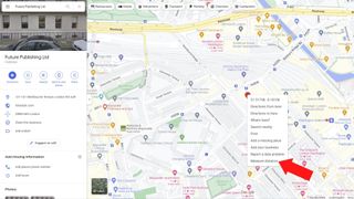
If you’re on a PC, you’ll first need to open up the Google Maps web page and use the search bar to look for your starting location. You can start from literally any point on the map you want.
Once you’ve found the right place, right-click on it on the map and a drop-down menu should appear. At the bottom of this menu, you’ll see an option for Measure distance; select it
2. Find the point you to measure to
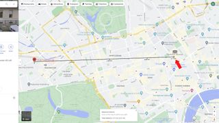
Once you've selected Measure distance , you'll then need to move the cursor until you find a second point you want to measure the distance to from your first marker.
After you've placed the second marker a small box should appear at the bottom of your screen that tells you the distance between the points. In our case, it tells us there’s 3.71km, or 2.31 miles, between our London office and the British Museum if you travel between them in a straight line.
3. Want to choose a different point to measure to?
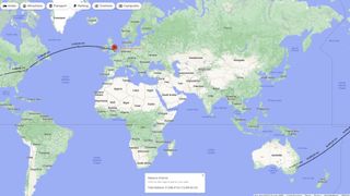
If you want to readjust the points you’re measuring, c lick and hold the white dot on either end of the line and drag it to a new location . Alternatively, you can click on another point and create a path that travels between multiple locations. Here we’ve measured the distance between our London, New York, and Sydney offices.
1. Open the Google Maps app and find your start point
On an iPhone or Android smartphone , open the Google Maps app (or download it from the App Store or Play Store if you don’t have it installed). Touch and hold on any point that isn’t a place name or location icon and a red pin will appear named 'Dropped pin'. Tap on it and a menu should appear with Measure distance near the top. Select this option.
2. Find your second point to measure to
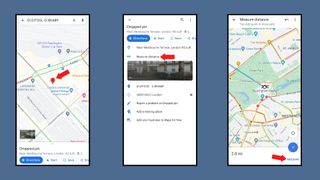
After selecting Measure distance an icon and a dotted blue line will appear. By dragging the map around you can place this icon at a second location to find out the distance between the two points on your map. Much like on a PC you can add more points on your journey to create a path that measures the distance between multiple locations.
To remove an erroneously placed point tap the Undo button . Pressing the three vertical dots to bring up the More menu and choosing Clear will get rid of all the points you've placed .
Unless you can phase through walls or take to the skies like Kitty Pryde and Angel from the X-Men , then measuring the direct distance between locations likely won’t tell you how far you’ll actually have to travel.
Case in point, traveling between our London office and the Britsh Museum would actually be a 2.7-mile (4.35km) journey on foot according to Google, rather than the 2.3 miles it gave us for the direct distance between them.
If you’re planning to walk or drive between the locations then the Google Maps directions tool on PC and smartphones is a much better choice for seeing how far you’ll have to travel. Much like the regular distance tool you can easily add locations to travel between and can add several destinations to create a route with multiple stops.
Want to find out about other cool Google Maps tricks? We have a guide that’ll teach you about 10 things you didn't know Google Maps could do , or check out our guide for how to download Google Maps.
- Looking for more great apps? Check out the best Android apps we've tested
Get daily insight, inspiration and deals in your inbox
Get the hottest deals available in your inbox plus news, reviews, opinion, analysis and more from the TechRadar team.

Hamish is a Senior Staff Writer for TechRadar and you’ll see his name appearing on articles across nearly every topic on the site from smart home deals to speaker reviews to graphics card news and everything in between. He uses his broad range of knowledge to help explain the latest gadgets and if they’re a must-buy or a fad fueled by hype. Though his specialty is writing about everything going on in the world of virtual reality and augmented reality.
NYT Strands today — hints, answers and spangram for Sunday, May 19 (game #77)
Track and share your activities like an absolute boss with this free app
Quordle today – hints and answers for Sunday, May 19 (game #846)
Explore and navigate your world
Discover new experiences across the world or around the corner.
Explore your world
With the redesigned Explore tab, find places to eat and things to do around you or when you travel
Just for you
See recommendations for new and trending places based on your interests
Create lists
Easily create lists of places you want to go, and add notes to the places you’ve saved. You can keep these lists private, share them with close friends, or share them publicly. You can also browse through lists created by publishers, Local Guides or Google
Make your plans happen by connecting with the places you’re interested in
Follow your favorites.
Stay on top of offers, updates and more when you follow your favorite businesses
Make a reservation, book an appointment, or get tickets with just a few taps
Get answers fast
Message a business right on Google Maps to find out information
Navigate the world around you
Real time traffic updates.
Find the best route when driving, with real-time updates on traffic jams, accidents, road closures and speed traps. You can also keep fellow drivers in the know by reporting incidents yourself
Hands-free help with the Google Assistant
Your Google Assistant is now integrated into Google Maps so you can message, call, listen to music and get hands-free help while driving. Say “Hey Google” to get started
Real-time updates for public transportation
Get up-to-the-minute updates on busses and trains, like departure times and how crowded the bus is. You can also see where on the map your bus is so you know if you need to walk a little faster to the bus stop
Explore new places confidently
With Live View in Google Maps, see the way you need to go with arrows and directions placed right on top of your world. There’s less second guessing and missing turns
Control your data with confidence
Industry-leading data protection.
Every day you’re Safer with Google. We use the most advanced technology like differential privacy to protect your data and build helpful features - like seeing how busy a place is so you can avoid the crowd.
Easy-to-use privacy controls
You’re in control. With Your data in Maps , you can easily view and manage your Location History and other account settings. Location History is off by default. When you turn on Location History, it can help you with real-time traffic predictions for your commute or reminisce about places you’ve been.
Search with Incognito mode
When you want additional privacy, use Incognito mode in Google Maps. When it’s turned on, you can navigate, search for places, and find business information from your device - all without searches or directions being saved in account.
See how people are using Google Maps to explore what’s around them, put their communities on the map, and help others
Why we map the world.
Map making is an ancient human endeavor, and one that those of us working on Google Maps are honored to continue to pursue
Mountain View, California
More stories
Melbourne, Australia
Mums who map
A group of Local Guides, Mums who Map, dedicated their time to help parents find kid-friendly places in Melbourne, Australia.
Nuku’alofa, Tonga
Mapping Tonga
Tania Wolfgramm and Wikuki Kingi set out to bring Tonga to Street View for all the world to see.
Devon Island, Canada
Together with the Mars Institute and NASA, Google Maps documented the research that goes on Devon Island, the most Mars-like place on Earth.
Norcia, Italy
Mapping Italy’s Recovery
One Local Guide records the aftermath of Italy’s earthquakes to show the world that they still need help recovering.
Kerala, India
Kerala Flood Rescue
Bobby Kurian used Google Maps to tag her parents’ location to help rescue them in the Kerala floods.
Supporting Women’s Rights
With the help of Local Guides and Google Maps, Princess Ilonze got hospitals and police stations on the map to help save lives.
Kids in India
The India Literacy Project teamed up with Google to help students explore the world through photos uploaded by Local Guide.
Bozeman, Montana
Connecting to Bozeman
One Local Guide was inspired to celebrate and show off her hometown in a unique way.
Sao Paulo, Brazil
Mapping Blood Donation Sites
Local Guide Adriano Anjos in Brazil mapped Sao Paulo’s blood donation centers on Google Maps.
London, England
Wheelchair Accessible Routes
Wheelchair-accessible routes on Google Maps has made getting around easier for Meridtyh, Omari, Adam, and Lucy.
Kolkata, India
Plus Codes creates geographical coordinates that provide an address to those who previously had none.
Grand Canyon National Park
Vets Kayak The Grand Canyon
Five blind veterans kayaked through the Grand Canyon and documented their journey on Street View.
Google Maps Blog
Read articles, interviews, and more to learn what’s new on Google Maps

Want the best prices for your trip? Google can help.
Take off to your next destination with Google Maps

Hip-hop dancers show Paris in a new light on Street View
There's more we can help you with.
Check out some related products below
Street View
Explore world landmarks, discover natural wonders, and step inside places with Street View on Google Maps
Google Earth
Explore worldwide satellite imagery, 3D buildings, and terrain for hundreds of cities with Google Earth
Local Guides
Become a Local Guide to help people everywhere find the places worth seeing and things worth doing
Google My Business
Stand out to people searching on Google, and connect with customers with a free business profile
Get Google Maps
- Coordinates
- Language (EN)
Map Distance Calculator
You can draw multiple circles, distances, areas or elevations, import/export data save and edit them later with a larger map! Try Calcmaps PRO
Note: To measure the distance on the google maps distance calculator tool. First zoom in, or enter the address of your starting point. Then draw a route by clicking on the starting point, followed by all the subsequent points you want to measure. You can calculate the length of a path, running route, fence, border, or the perimeter of any object that appears on a google map. The distance calculator will then display a measurement of the length in feet, meters, miles and kilometers.
Share using this link
Distance Converters
There’s a lot your users can figure out about a place just by exploring your map–what’s nearby, whether the locations are relatively close to each other, and even roughly how far a place is based on the map’s scale. With Google Maps Platform you can take some of the guesswork out of the picture by quantifying distances via straight line distance and route distance . Each uses a different approach and solves for different user problems or actions. So today we’re explaining what each is, when to use one over the other, and how to get started.
To make these points, we’ll plot some distances on a map with some handy JavaScript. And because to calculate any sort of distance requires point A and point B, we’ll start by adding two markers to a basic Google Map:
Here we can see Central Park, as well as two nearby landmarks. The Dakota, perhaps most famous as John Lennon’s home. And The Frick Collection, an art gallery.
Suppose these were both on a New York City tour. You might be interested to know how far it is from one to the other. We’ll answer that question with some 200 year-old number crunching.
**Calculate the straight line distance from latitude and longitude**The simplest method of calculating distance relies on some advanced-looking math. Known as the Haversine formula, it uses spherical trigonometry to determine the great circle distance between two points. Wikipedia has more on the formulation of this popular straight line distance approximation.
To visualize the calculation, we can draw a Polyline between the two markers. Add the following lines after the markers in the JavaScript:
Reload the map and you should see a dark, diagonal line connecting the two markers, from one side of Central Park to the other. Using the JavaScript equivalent of the Haversine formula, we can determine the length of the Polyline, the straight distance between our two markers.
Add this function to your JavaScript, before the initMap function:
The function accepts two marker objects and returns the distance between them in miles. To use kilometers, set R = 6371.0710 . Before applying the Haversine formula, the function converts each marker’s latitude and longitude points into radians.
To call the function and report the distance below the map, add this code below your Polyline in the initMap function:
Load the map and you’ll see the following:
Now we know the straight line distance between The Dakota and The Frick Collection is 0.60 miles (rounded to two decimal places using the JavaScript toFixed function).
Of course, unless you’re a pigeon, your jaunt between the two locations is likely to be longer. A quick glance at the map shows there is no road or even pathway straight across Central Park. The Haversine formula is useful for basic proximity, but is insufficient for many use cases, especially within cities. For a more accurate travel distance, we’ll need to use another feature of the Maps JavaScript API.
**Get Directions with the Maps JavaScript API**When the straight line distance is not adequate, you’ll need more than a formula to determine the travel distance. Driving directions are one of the most popular features in Google Maps, so it’s unsurprising that it’s also made available via an API. You can use the Directions API for server-side requests, or the Directions Service in the Maps JavaScript API for client-side requests on the web.
Since our JavaScript map is already set, we’ll continue by using the Directions Service. Paste the following at the end of your initMap function:
After a successful call to the directions service, you’ll have the route added to the map. The message below the map is also extended to include the distance.
With a quick visual inspection, it’s clear that driving directions are much farther than the straight line distance. We can dig into the data that comes back in the response to find driving distance (1.6 miles, two and a half times farther), as well as the estimated duration. Here’s a JSON representation of the relevant section from the response:
While our example used driving directions, you can also pass other values to the travelMode field in your route object. The directions service can also accept BICYCLING , TRANSIT , and WALKING values. Try adjusting the mode and running the code again to see how the directions result changes.
Which distance should I use? The two distance types in this post are useful in different scenarios. To give your users the best experience, you should use each in the appropriate situation.
You can use straight line distance to make quick calculations without a call to an external service. You’ll need to include the Haversine function used in this tutorial, but all you need are map coordinates to get an accurate result within the browser. However, as the name suggests, the distance will be a simple straight line. Roads, obstructions, and traffic are not factored into straight line distance.
Route distance, on the other hand, will return the distance along a route, including necessary turns and an understanding of the area’s traffic patterns. Due to the complexity of these calculations, route distance requires a call to the Directions Service, which will also return the duration of the route and even the path to plot visually on a map.
Whether you’re measuring distances around the globe or across town, use one of these approaches to help your users better understand their surroundings and make decisions. To explore even more tools for helping users get from here to there, check out the Google Maps Platform Routes APIs . And for more information on Google Maps Platform, visit our website .

Quick Links
Who uses travelmath.
Companies like United Airlines, Southwest Airlines, and Ryanair use Travelmath to re-route passengers and plan new flight paths.
Celebrities love Travelmath!
"Travelmath is the one app I couldn't live without - it calculates all your journey timings and because I travel a lot, it's essential. Whoever invented Travelmath, I love you! " – Drew Barrymore
"There's a website called Travelmath, it's really good if you're into flight times. " – Blake Griffin
Dirtiest Public Transit
See the research from our Travelmath study on public transportation hygiene. How does the New York subway rank against Chicago, DC, SF, and Boston? Read the full study!

Germiest Hotel Rooms
See even more research from our Travelmath study on hotel hygiene. Spoiler alert: Don't turn on the TV... Read the full study!
Travel Tools
What is travelmath.
Travelmath is an online trip calculator that helps you find answers quickly. If you're planning a trip, you can measure things like travel distance and travel time . To keep your budget under control, use the travel cost tools.
You can also browse information on flights including the distance and flight time. Or use the section on driving to compare the distance by car, or the length of your road trip.
Type in any location to search for your exact destination .
Quick Calculator
How do i search.
To get started, enter your starting point and destination into the boxes above. If you want an airport , it's best to enter the 3-letter IATA code if you know it. For cities , include the state or country if possible.
You can also enter more general locations like a state or province , country, island , zip code, or even some landmarks by name.
Check Prices
Home · About · Terms · Privacy
Mileage Calculator
Use the following mileage calculator to determine the travel distance, in terms of miles, and time taken by car to travel between two locations in the United States, disregarding traffic conditions.
Flight search
- Adults Remove adult 1 Add adult
- Children Aged 2-11 Aged 2 to 11 Remove child 0 Add child
- Infants In seat Remove infant in seat 0 Add infant in seat
- Infants On lap Remove infant on lap 0 Add infant on lap
- Premium economy
Find cheap flights from Russia to anywhere Close dialog These suggestions are based on the cheapest fares to popular destinations in the next six months. Prices include required taxes + fees for 1 adult. Optional charges and bag fees may apply.
- Saint Petersburg
Useful tools to help you find the best deals
Popular destinations from russia.
Frequently asked questions
- Help Center
- Google Maps
- Privacy Policy
- Terms of Service
- Submit feedback
Get directions and show routes
You can get directions for driving, public transport, walking, ride sharing, cycling, flights or motorcycling on Google Maps. If there are multiple routes, the best route to your destination is blue, all other routes are grey. Some directions in Google Maps are in development and may have limited availability.
Important: Stay alert when you use directions on Google Maps. Always be aware of your surroundings to ensure the safety of yourself and others. When in doubt, follow actual traffic regulations and confirm signage from the road or path that you’re on.
- On your computer, open Google Maps .
- Click points on the map, type an address or add a place name.
- Choose your mode of transportation.
Tip: To choose another route in any transportation mode, select it on the map. Each route shows the estimated travel time on the map.
Google Maps transportation modes
You can get directions for different modes of transportation in Google Maps. Learn about the differences in features and availability between each mode:
- If you want to change a driving route, click and hold a spot on the route and drag it to a new spot on the map.
- Not all cities have public transport directions in Google Maps. Before you can get public transport directions, your local transport operator needs to add their route info to Google Maps.
- If you want directions in an area with ride or taxi services, you can compare ride services with public transport and walking directions. Find out how to request a ride .
- Directions to multiple destinations, or waypoints, aren’t available for public transport or flight searches.
- Learn more about how to search for flights .
- Learn how to get directions for motorcycles .
Add multiple destinations
You can get directions to multiple destinations for all modes of transportation except public transport or flight.
- Add a starting point and a destination.
- You can add up to nine stops.
- Click on a route to get the directions.
Tip : You can search for places along your route.
To change the order of your stops:
- Find the destination that you want to move.
- Drag the destination.
Preview directions in Street View
- On your computer, under the route you want, click Details.
- Point to a step in the directions. If Street View is available, you get a preview photo.
- To get Street View for other steps in the route, in the bottom-left box, click Previous step or Next step.
Customise your route
- Choose Options .
- Tick the box next to 'Tolls' or 'Motorways'.
- Get directions.
- After you get your directions, click Leave now .
- To change your travel dates or times, select Depart at or Arrive by .
When you enter a destination in Google Maps, we show you how to get there using different travel modes, like driving, cycling or walking.
Sometimes, the transport options that we show you are ranked according to a combination of objective factors designed to help you find relevant and useful information. These factors can include duration, distance, price, your mode preference or the relevance of a mode to your query. Generally, the most important factors are your mode preference, trip durations and sometimes price.
Where available, we also show you other mobility services like public transport, scooter or bicycle rentals and vehicle ride services. These mobility services are provided by third parties who have made their transport data publicly available or who have a partner agreement with us. Any partnerships or business relationships that we may have with any transport service providers do not influence the ranking of these services.
Related resources
- Get traffic or search for places along the way
- Plan your commute or trip
Was this helpful?
Need more help, try these next steps:.
Download Now
- Google Maps Platform
- Español – América Latina
- Português – Brasil
- Tiếng Việt
- Web Services
- Distance Matrix API
- Documentation
Distance Matrix API overview
Why use the distance matrix api.
You can use the Distance Matrix API to help determine the most efficient travel routes between multiple possible origins and destinations. For example, which workers to send to job sites, or from which warehouses to send packages.
What can you do with the Distance Matrix API
With the Distance Matrix API, you can provide travel distance and time for a matrix of origins and destinations. You can specify several options, including mode of transportation, such as driving, biking, transit or walking, as well as transit modes, such as bus, subway, train, tram, or rail.
The Distance Matrix API provides information based on the recommended route between start and end points. You can request these kinds of distance data:
- Distance for a selected travel mode
- Distance in kilometers or miles
- Estimated travel time in traffic
How the Distance Matrix API works
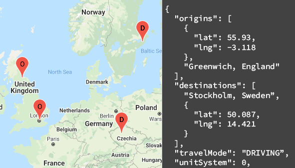
The Distance Matrix API uses any number of origins (starting points) and destinations, and returns the distance and travel time between each origin and all requested destinations, starting with the first origin in the request and proceeding step-wise to the next.
For example, if your request specifies A and B as origins, and C and D as destinations, it returns distances and travel time in this order:
The following example shows a request for two origins: Washington, DC and Boston, with a single destination, New York City, NY, in JSON format:
The following table summarizes the resources available through the Distance Matrix API along with the data it returns.
How to use the Distance Matrix API
Available client libraries.
Call this API in the language of your choice through one of the following client libraries:
- Java Client for Google Maps Services
- Python Client for Google Maps Services
- Go Client for Google Maps Services
- Node.js Client for Google Maps Services
The Java Client, Python Client, Go Client and Node.js Client for Google Maps Services are community-supported client libraries, open sourced under the Apache 2.0 License . Download them from GitHub, where you can also find installation instructions and sample code.
What's next
- Start using the Distance Matrix : Go to Get Started .
- Get started with sample requests and responses : Go to Distance Matrix request and response
- Follow best practices : Go to Web Service Best Practices .
Except as otherwise noted, the content of this page is licensed under the Creative Commons Attribution 4.0 License , and code samples are licensed under the Apache 2.0 License . For details, see the Google Developers Site Policies . Java is a registered trademark of Oracle and/or its affiliates.
Last updated 2024-05-15 UTC.
Google Maps Formulas for Google Sheets

Use Google Maps formulas inside Google Sheets to calculate distances, travel time, get driving directions, look up postal codes with reverse geocoding and more!
You can bring the power of Google Maps to your Google Sheets using simple formulas with no coding. You don’t need to sign-up for the Google Maps API and all results from Google Maps are cached in the sheet so you are unlikely to hit any quota limits.
To give you a quick example, if you have the starting address in column A and the destination address in column B, a formula like =GOOGLEMAPS_DISTANCE(A1, B1, "driving") will quickly calculate the distance between the two points.
Or modify the formula slightly =GOOGLEMAPS_TIME(A1, B1, "walking") to know how long it will take for a person to walk from one point to another.
If you would like to try the Google Maps formulas without getting into the technical details, just make a copy of this Google Sheet and you are all set.
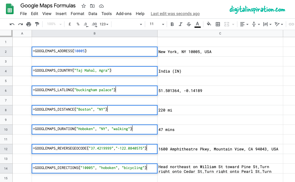
Using Google Maps inside Google Sheets
This tutorial explains how you can easily write custom Google Maps functions inside Google Sheets that will help you:
- Calculate distances between two cities or any addresses.
- Calculate the travel time (walking, driving or biking) between two points.
- Get the latitude and longitude co-ordinates of any address on Google Maps.
- Use reverse geocoding to find the postal address from GPS co-ordinates.
- Print driving directions between any points on earth.
- Get the address from the zip code itself.
1. Calculate Distances in Google Sheets
Specify the origin, the destination, the travel mode (walking or driving) and the function will return the distance between the two points in miles.
=GOOGLEMAPS_DISTANCE("NY 10005", "Hoboken NJ", "walking")
2. Reverse Geocoding in Google Sheets
Specify the latitude and longitude and get the full address of the point through reverse geocoding of coordinates.
3. Get the GPS coordinates of an address
Get the latitude and longitude of any address on Google Maps.
=GOOGLEMAPS_LATLONG("10 Hanover Square, NY")
4. Print the driving directions between addresses
Specify the origin address, the destination address, the travel mode and the function will use the Google Maps API to print step-by-step driving directions.
=GOOGLEMAPS_DIRECTIONS("NY 10005", "Hoboken NJ", "walking")
5. Measure the trip time with Google Maps
Specify the origin address, the destination address, the travel mode and the function will measure your approximate trip time between the specified addresses, provided a route exists.
=GOOGLEMAPS_DURATION("NY 10005", "Hoboken NJ", "walking")
Tip: Improve Formula Performance by Caching
The Google Sheets functions internally use the Google Maps API to calculate routes, distances and travel time. Google offers a limited quota for Maps operations and if your sheet performs too many queries in a short duration, you are likely to see errors like ""Service invoked too many times for one day” or something similar.
To get around the quota issue, it is recommended that you use Apps Script’s built-in cache to store results and, if the results of a function already exist in the case, you’ll make one less request to Google Maps.
The Maps functions inside this Google Sheet also use caching and here’s how you can implement it.
Also see: Embed Google Maps in Emails and Documents
Amit Agarwal
Google Developer Expert, Google Cloud Champion
Amit Agarwal is a Google Developer Expert in Google Workspace and Google Apps Script. He holds an engineering degree in Computer Science (I.I.T.) and is the first professional blogger in India.
Amit has developed several popular Google add-ons including Mail Merge for Gmail and Document Studio . Read more on Lifehacker and YourStory
Awards & Titles
Digital Inspiration has won several awards since it's launch in 2004.
Google Developer Expert
Google awarded us the Google Developer Expert award recogizing our work in Google Workspace.
ProductHunt Golden Kitty
Our Gmail tool won the Lifehack of the Year award at ProductHunt Golden Kitty Awards in 2017.
Microsoft MVP Alumni
Microsoft awarded us the Most Valuable Professional (MVP) title for 5 years in a row.
Google Cloud Champion
Google awarded us the Champion Innovator title recognizing our technical skill and expertise.
Video Tutorials
Subscribe to our YouTube channel and get notified whenever we upload a new video tutorial.

Google Add-ons
We build bespoke solutions that use the capabilities and the features of Google Workspace for automating business processes and driving work productivity.
Mail Merge with Attachments
Send personalized email to your contacts with Google Sheets & Gmail

Document Studio
Create pixel perfect documents from Google Sheets and Google Forms

Save Emails and Attachments
Download emails and attachments from Gmail to your Google Drive

Google Forms Email Notifications
Send email to respondents when they submit your Google Forms

Email Google Spreadsheets
Email entire spreadsheets, selected cell ranges or send dynamic charts on schedule.

Creator Studio for Google Slides
Turn your Google Slides presentations into animated GIF images and videos

Email Newsletter
Sign up for our email newsletter to stay up to date.
We will never send any spam emails. Promise.
Google Takes Next Step in AI Trip Planning
Justin Dawes , Skift
May 14th, 2024 at 4:57 PM EDT
Google is fully in its Gemini era. That’s what executives repeated as they showcased how AI pulls information from across its products to create detailed trip plans and more.
Justin Dawes
Google is diving head first into AI-powered trip planning.
Gemini Advanced , the paid version of the Gemini generative AI chatbot, will soon be able to build travel itineraries with a simple prompt in easy-to-understand language.
It’s also strengthening trip-planning options for AI Overviews, the AI feature it released this year for a traditional Google search. AI Overviews has been available only to U.S. users that opt in, but it’s being released to all U.S. users this week and more countries soon.
The search giant revealed the plans on Tuesday at its annual developer conference, Google I/O. Or, as Google CEO Sundar Pichai called it: “Google’s version of The Eras Tour with fewer costume changes.”
To try early versions of these new tools, opt in to AI experiments with Google Search Labs .
Skift will perform its own tests of the updated tools as soon as they are available.
Itinerary Building in Gemini Advanced
Sissie Hsiao, vice president of Google and general manager for Gemini experiences, used a travel example to illustrate how the chatbot is taking a step closer toward the goal of being a “true AI assistant.”
The example started with a prompt: “My family and I are going to Miami for Labor Day. My son loves art and my husband really wants fresh seafood. Can you pull my flight and hotel information from Gmail and help me plan the weekend?”
In the background, the AI creates potential travel options from multiple sources of information. “The result is a personalized vacation plan,” Hsiao said.
Looking at the flight itinerary, the AI knows it needs to create a plan within the length of the trip and allow time before and after each flight.
The flight in the example lands at 4:28 p.m., so the AI doesn’t recommend a big activity but rather three fresh seafood restaurants for 7:30 p.m. It estimates a 20-minute drive from the airport, an hour to drop off bags and freshen up, and 15 minutes to walk to dinner.
The next day is full of proposed activities. Make an adjustment, such as changing the start time, and the AI automatically repopulates its plan.
The trip-planning capability is coming to Gemini Advanced this summer.
Google released Gemini Advanced in February with its most up-to-date AI model at the time. The platform is now getting an upgrade with Google’s latest AI model, Gemini 1.5 Pro, available in 35 languages.
Travel Recommendations in Google Search
Google showed how users can get upgraded tourism recommendations through the traditional search bar.
The upgraded tech is better at answering multi-faceted questions, said Liz Reid, vice president of Search, during the conference.
A prompt that Google used as an example: “What are good options for a day out in Dallas with the kids? Recommend some ice cream shops near each option.”
The first option was the Dallas Zoo, and it listed three ice cream shops nearby.
The other options were Dallas Arboretum and the Perot Museum of Nature and Science, along with three ice cream shop options for each. There was also a map below the results that showed each of their locations.
“Research that might have taken you minutes or even hours, Google can now do on your behalf in just seconds,” Reid said.
Reid demonstrated the capability during the conference with an example of searching for a yoga studio in Boston .
There was a video later with a quick clip showing the above example.
Travel Inspiration in Google Search
Google is also upgrading Search to respond with fuller recommendations during the brainstorming stage, when the prompts are typically less specific. The response includes groups of suggestions organized by the AI.
“What you get here breaks AI out of the box, and it brings it to the whole page,” Reid said.
The example prompt: “Anniversary celebration dinner places Dallas.”
The AI responded with several groups of restaurants based on themes it created: Anniversary-worthy restaurants, restaurants with live music and intimate settings, and historic charm and elegance.
The model also uses contextual factors, like time of the year, Reid said. Since it’s warm now in Dallas, it included a group of options for “romantic” rooftop dining dates.
These AI-organized results pages for brainstorming searches are coming soon for dining and recipes, then expanding to later to include hotels and more.

Have a confidential tip for Skift? Get in touch
Tags: artificial intelligence , google , google gemini , online travel , the prompt , trip planning
Photo credit: Google is releasing more trip planning capabilities power by its Gemini generative AI model. Google
Driving Distance Calculator and Driving Directions Canada

Canada Distance Calculator and Driving Distance Between Cities
- Enter the "Distance From" city, village, town, airport or place name from Canada in the first text box.
- Enter the "Distance To" city, village, town, airport or place name from Canada in the second text box.
- You can also enter airport name or code from Canada in above fields.
- This will display the dropdown with suggested places in Canada; Select the desired Address /Place /City /Village /Town /Airport from both the dropdown lists.
- Click the "Get Distance & Directions" button to get the distance between the selected addresses /places /cities /towns /villages /airports in Canada.
- British Columbia
- New Brunswick
- Northwest Territories
- Nova Scotia
- Prince Edward Island
- Saskatchewan
- Yukon Territory
- Newfoundland and Labrador

IMAGES
VIDEO
COMMENTS
Find local businesses, view maps and get driving directions in Google Maps.
On your computer, open Google Maps. Click Directions . Add a starting point and a destination. On the left, below the destinations you entered, click Add . To add a stop, choose another destination. You can add up to 9 stops. Click on a route to get the directions. Tip: You can search for places along your route.
Use the distance calculator map to find the distance between multiple points along a line. To measure the distance on the google maps distance calculator tool. First zoom in, or enter the address of your starting point. Then draw a route by clicking on the starting point, followed by all the subsequent points you want to measure.
1. Open Google Maps in a web browser. 2. Right-click anywhere on the map that you want to set as a starting point. In the dropdown menu, choose Measure distance. Right-click on the map and choose ...
On your computer, open Google Maps. Make sure you're signed in. On the left, choose an option: Get directions to relevant places: Click a place in the list. You'll get places based on your Gmail, Calendar, and recent travel history. Get directions to saved places: If you saved your work or home address in your Google Account, click Home or ...
At the bottom, tap Go . Search for your destination in the search bar at the top. At the bottom, tap on "Directions.". At the top, select your transportation mode. Select your preferred route. At the bottom, tap Pin . You can pin your trip and find it back in the Go tab next time you need it. Tip: Pinning only works with "Driving" and ...
On your Android phone or tablet, open the Google Maps app . Open Google Maps. If you don't yet have the app, download it from the Play Store. Search for your destination or tap it on the map. In the bottom left, tap Directions . Choose your mode of transportation. For Driving Transit you can pin your favorite trips.
Steps for how to measure distance on Google Maps. Open Google Maps on a PC or smartphone. Choose a starting location and place a pin. Click on the pin and choose 'Measure distance'. Place a path ...
Explore world landmarks, discover natural wonders, and step inside places with Street View on Google Maps. Explore worldwide satellite imagery, 3D buildings, and terrain for hundreds of cities with Google Earth. Become a Local Guide to help people everywhere find the places worth seeing and things worth doing.
Plan your trip with Google. Find flights, hotels, vacation rentals, things to do, and more.
Driving distances between two cities. Travelmath helps you find driving distances based on actual directions for your road trip. You can get the distance between cities, airports, states, countries, or zip codes to figure out the best route to travel to your destination. Combine this information with the fuel cost tool to find out how much it ...
You can calculate the length of a path, running route, fence, border, or the perimeter of any object that appears on a google map. The distance calculator will then display a measurement of the length in feet, meters, miles and kilometers. Use the distance calculator map to find the distance between multiple points along a line.
To call the function and report the distance below the map, add this code below your Polyline in the initMap function: // Calculate and display the distance between markers. var distance = haversine_distance(mk1, mk2); document.getElementById('msg').innerHTML = "Distance between markers: " + distance.toFixed(2) + " mi.";
What is Travelmath? Travelmath is an online trip calculator that helps you find answers quickly. If you're planning a trip, you can measure things like travel distance and travel time.To keep your budget under control, use the travel cost tools. You can also browse information on flights including the distance and flight time. Or use the section on driving to compare the distance by car, or ...
Features. Learn about core features of the Distance Matrix API. Get traffic information. Make a distance matrix request that calculates travel time based on current traffic conditions. Specify side of road. Specify whether a calculated route should pass through a particular side of the road.
Mileage Calculator. Use the following mileage calculator to determine the travel distance, in terms of miles, and time taken by car to travel between two locations in the United States, disregarding traffic conditions. From: To: This mileage calculator estimates the number of driving miles between two locations in the United States.
How far is it from one place to another? Use MapQuest's distance calculator to measure the driving distance, walking distance, or air distance between any two locations. You can also compare the travel time and cost of different modes of transportation. Whether you're planning a trip, running an errand, or just curious, MapQuest's distance calculator helps you find the best route for your journey.
Provide up to 26 locations and Route Planner will optimize, based on your preferences, to save you time and gas money. Find the shortest routes between multiple stops and get times and distances for your work or a road trip. Easily enter stops on a map or by uploading a file. Save gas and time on your next trip.
Use Google Flights to explore cheap flights to anywhere. Search destinations and track prices to find and book your next flight.
On your computer, open Google Maps. Click Directions . Click points on the map, type an address or add a place name. Choose your mode of transportation. Tip: To choose another route in any transportation mode, select it on the map. Each route shows the estimated travel time on the map.
With the Distance Matrix API, you can provide travel distance and time for a matrix of origins and destinations. You can specify several options, including mode of transportation, such as driving, biking, transit or walking, as well as transit modes, such as bus, subway, train, tram, or rail. The Distance Matrix API provides information based ...
The Google Sheets functions internally use the Google Maps API to calculate routes, distances and travel time. Google offers a limited quota for Maps operations and if your sheet performs too many queries in a short duration, you are likely to see errors like ""Service invoked too many times for one day" or something similar.
Google is diving head first into AI-powered trip planning. Gemini Advanced, the paid version of the Gemini generative AI chatbot, will soon be able to build travel itineraries with a simple prompt ...
Timmins (Ontario) 675.83. Chateauguay (Quebec) Quinte West (Ontario) 329.42. Georgina (Ontario) Rimouski (Quebec) 949.56. Canada Driving Distance Calculator to calculate driving distance between cities, towns or villages in Canada and Mileage Calculator, Distance Chart, Distance Map.