
Cycling the Route des Grandes Alpes from Geneva to Nice: Q&A with France Bike Trips
The Route des Grandes Alpes is one of Europe’s iconic cycling routes, taking you through the French Alps, from Geneva to Nice.
This 720 kilometre traverse of the Alps winds along mountain sides, glaciers, mountain pastures and forests, taking in around 17,100m of climbing and 18 major cols; mythical beasts such as the Col de l’Iseran, Col du Galibier, Col du Lautaret, Col d’Izoard.
It’s one of the must-do cycling tours in France (and Europe) but it’s not for beginners!
Insider guide: Route des Grandes Alpes
It’s a journey that’s been on our bucket list for many years now, so when Vélorizons offered to share the inside story on the Route des Grandes Alpes cycle tour, we jumped at the chance.
Vélorizons is a well-established cycling tour operator in France; France Bike Trips is their English-language branch.
Vincent is Vélorizons’ road cycling product manager; he’s been planning cycling holidays in the Alps for fifteen years.
Of all the routes he’s planned and led trips on, Vincent tells us that this is one of his personal favourites.
Here he shares his tips.
Vélorizons’ UK language brand is called France Bike Trips ( www.france-bike-trips ). Throughout this article we will refer to Vélorizons (as it’s shorter!).
Details of their Route des Grandes Alpes trip are here .
Note all distances and gradients etc in this article are approximate.
Part 1: Route des Grandes Alpes cycle route
1. tell us about the route des grandes alpes cycle tour, how did it start.
The Route des Grandes Alpes dates all the way back to 1860, when Napoleon III annexed Savoie and Nice to France. The army was told to build roads to open routes between the valleys of France and into the newly annexed Savoie and Nice.
A few years later, the Touring Club de France got interested and in 1909, the vice-president of the Club, Leon Auscher, said “It will be a unique route in Europe… and the finest mountain road in the world.”
The Route des Grandes Alpes’ original itinerary was inaugurated in 1937. Today the Route des Grandes Alpes remains one of the most famous and beautiful European cycle routes.
Some statistics…
The route crosses the entire French Alps from north to south, taking in 18 high mountain passes (cols).
Six of the cols are over 2,000 metres high: Col de l’Iseran, Col du Galibier, Col du Lautaret, Col d’Izoard, Col de Vars and Col de la Cayolle. Other famous Tour de France climbs include the Col de la Colombière, Col des Aravis, Col des Saisies, Cormet de Roselend, Col du Télégraphe and Col du Turini.
This legendary Geneva to Nice cycling tour starts in the lovely town of Thonon-les-Bains on the shore of Lake Geneva and ends in Nice on the Côte d’Azur (not far from Nice).
In total, cyclists have to cover 710 km in distance and a total of 17,100 metres of climbing.

2. What makes cycling Geneva to Nice on the Route des Grandes Alpes one of the best cycle routes in Europe?
The Route des Grandes Alpes sits up there alongside Route 66 or the Silk Road as one of the most beautiful roads in the world. It’s also one of the toughest and longest classic road cycling itineraries there is.
Crossing the French Alps, from North to South, from lake shore to Mediterranean coast, by bike is really something special.
The scenery is incredible; panoramic view follows panoramic view.
You also get the chance to appreciate the variety of Alpine landscapes along the way, from Mont Blanc to the Southern Alps and finally to the hinterland of Nice; it’s amazing how different the landscapes look when you’re cycling through the Alps day after day, one mountain range after another.
For those that like to tick off the famous cols, the route gives you the chance to conquer some of the most iconic climbs of the Tour de France and some of the highest paved roads in Europe. Staying in the Alpine villages also really gives you a feel for the local culture and local passion for the Tour de France.
The authentic produce is fantastic too – for example Alpine cheese specialities such as Beaufort, Abondance and Tomme de Savoie. You definitely have to taste them as you pass through the regions!

3. Give us a feel for what each day is like
Our Route des Grandes Alpes cycle tour takes eight full days of cycling. It takes in all the major sections of the Route des Grandes Alpes, but improves on it to avoid main road sections with higher traffic volume, notably in the valleys.
We offer two different levels of route, level 2 and level 3. Level 2 is slightly easier than level 3 and most closely follows the classic Route des Grand Alpes itinerary.
- Level 2: 690 km and 16,100 m of climbing
- Level 3: 850 km and 21,100 m of climbing (not including optional return trips to Col du Joly, Col du Mont Cenis and Cime de la Bonette, see details in the comments below).
There’s no such things as an easy day on this trip – but relatively speaking, if you choose level 2, days 1, 5, 6, and 7 are slightly easier. The hardest days are between days 2 and 5.
We always recommend our guests take it easy on the first days, based on your experience, and listen to their body throughout the trip in order to adapt their effort. If you’re on one of our trips, you can choose the level each day, depending on how you’re feeling and whether you prefer the look of the level 2 or 3 route that day.
Day 1 Thonon-les-Bains – La Clusaz: Crossing the Chablais mountains
Day 1 of your Geneva to Nice cycle challenge takes you into the idyllic Chablais mountains.
The beautiful valleys of Abondance and Giffre and the Portes du Soleil resort area offer us the perfect conditions to get our legs turning. Things get serious when attacking the Aravis mountain range with their sharp-edged peaks and impressive rocky crags.
The first real challenge is the Col de la Colombière: from the start in Marnaz, a ramp with 11% awaits. When the gradient calms down around Le Reposoir, spare some energy for the upcoming finish of La Colombière, roughly 3 km with 10% in average (especially challenging on hot days).
On top of the Colombière, the pine forests give way for the first time to the picture-book Savoy Alpine pastures.
In the descent we reach Le Grand-Bornand and La Clusaz, both well-known ski resorts known for the beauty and authenticity of their chalets. Cowbells dominate the soundscape for the evening of our first stopover.
Route variant
On our level 3 trip, we also take in the difficult Col du Joux Plane from Morzine with 7 km above 9 % (1 km at 11 %). You’ll recognise it from the Tour de France stages!
Cols of the day
Col de Jambaz (1,027 m) (level 2 only)
Col de Joux Plane (1,712 m) (level 3 only)
Col de la Colombière (1,613 m)
Distance and climbing
Level 2: 90 km and 2,200 m
Level 3: 120 km and 3,300 m

Day 2 La Clusaz – Bourg Saint Maurice: Into the heart of the French Alps
On the second day, you leave the Pre-Alps and enter more serious terrain.
First things first: you start with the climb up the Col des Aravis (1,486 m) with its perfectly laid-out hairpin bends amidst the Alpine meadows.
From the pass you have a breath-taking view of Mont Blanc and its glaciated neighbouring peaks.
You then enter the narrow gorge valley of the Val d’Arly, which you leave shortly afterwards towards the cross-country skiing resort of Les Saisies, seated at 1,650 m.
You now descend into the Beaufortain, a picture-book landscape of chalets, alpine meadows, mountain forests and mountain peaks. Beaufortain is also famous for its firm, raw cow’s milk cheese of the Gruyère family.
From here you can also spot the rocky spur of the Pierra Menta in the distance, landmark of the well-known ski mountaineering event.
A little further on and you are already climbing the Cormet de Roselend (1,967 m), whose picturesque reservoir awaits with its turquoise waters.
The last descent is into the Tarentaise valley, one of the two main valleys of Savoie, under the gaze of the Aiguille des Glaciers.
Today’s overnight stay is in Séez above the town.
Gradients remain moderate between 6-8 % on today’s cols.
On our level 3 trip, you can take in a return journey to Col du Joly and a more difficult ascent of the Cormet de Roselend via the Col du Pré (average of 8% with some ramps reaching 11%). The Col du Joly is a natural balcony of the Mont Blanc, offering an exceptional panoramic view of the Mont Blanc range, the Contamines valley and the Aravis mountain range.
Col des Aravis, 1,486 m
Col des Saisies, 1,650 m
Col du Joly, 1,989 m (level 3, optional return ride)
Col du Pré, 1,703 m (level 3)
Cormet de Roselend, 1,967 m
Level 2: 90 km and 2,600 m
Level 3: 100 km and 2,800 m (Col du Joly option: + 28 km and 900 m)

Day 3 Bourg Saint Maurice – Val Cenis: The Iséran
Today you connect the two biggest Alpine valleys of Savoy – the Tarentaise (Isère valley) and the Maurienne (valley of the Arc river) – by crossing the famous Col de l’Iseran at 2,762 m altitude.
The route takes you close to the main alpine ridge which separates France from Italy.
The long and demanding ascent of the Col de l’Iseran from the north is 47 km, making it the longest mountain pass in France. However, gradients are moderate with 4% average and 7% max. The road leads you first up to the busy ski resort of Val d’Isère, before entering high-alpine terrain on the last 16 km. You’ll enjoy beautiful views on this, your first high mountain experience of the route. Albeit the moderate gradients, you have to climb 2,000 m to reach the Iseran’s magnificent summit.
The similarly long descent leads you down the wild valley of the Higher Maurienne. On the way, you can enjoy countless panoramas of the peaks and glaciers of the Vanoise National Park, and pass through one of the most beautiful villages in the French Alps: Bonneval-sur-Arc, with its well-preserved stone houses.
The further the descent leads us into the valley, the higher the mountain giants tower to the left and right. You reach today’s destination, Val Cenis, just below this mountain pass on the Alpine Italian border (if you wish, you can carry on up to the top of the Col du Mont Cenis before returning to our accommodation for the night).
Col de l’Iseran, 2,762 m
Col du Mont Cenis, 2,083 m (optional return trip)
Level 2: 80 km and 2,200 m
Level 3: 90 km and 2,600 m (+15 km and 750m for the optional ride to Col du Mont Cenis)

Day 4 Val Cenis – Serre Chevalier: The Galibier
Today is another big day, and it includes the most famous Alpine string of the Tour de France and 2,000 m of climbing for one col, the mythical Col du Galibier (2,645 m).
You start with a beautiful balcony road through larch and pine forests to avoid the main road in the valley. From Modane, a gentle route leads you downhill towards Saint-Michel de Maurienne. Here you start your attack on the Galibier. You first climb up the large but winding road of the Col du Télégraphe, mostly in the forest (12 km, 7,5 % in average).
In the following short but welcome descent, down to Valloire, you can recharge your batteries.
The real climb to the Galibier begins when leaving the lively town centre of Valloire with gradients up to 10 %.
Surrounded by dry pastures and the stony but elegant peaks of the Cerces massif, you reach Plan Lachat. After having taken one of the most famous bends in France at Plan Lachat, the last part of the ascent begins. There are still 8 km to the Col du Galibier. The road rises suddenly and attacks the gullied flank of the Roche Olvéra (alt. 2,662 m). The effort is intense: the slope rarely drops below 8 % withs peaks around 9%, you are at more than 2,000 m, the bends offer little flatness. Short passages of 7,5 % are appreciated.
Approaching the tunnel, one last kilometre remains to the top: you’ll need to gather all your courage and use your last strength to cover a final series of rather steep bends at 9,5 %.
On top of the Galibier, at 2,642 m, the reward is a magnificent panorama of the Grandes Rousses Massif to the north and the Ecrins Massif to the south with the glaciers of La Meije. Savour these views on the entire descent to the Col du Lautaret.
All that remains is to let yourself roll down further into the sun-drenched valley of Serre Chevalier. Overnight stay in Le Monêtier les Bains.
On level 3, for those who are fit, we offer a route variant via three other famous cols: Croix de Fer, Glandon and up the Lautaret. This itinerary takes you right into the heart of the lovely Arves range, with splendid views on the Aiguilles d’Arves and the crossing of Bourg d’Oisans, the road cycling mecca below the bends of Alpe d’Huez. However, it makes for a very long and hard day!
Col du Télégraphe, 1,566 m (level 2)
Col du Galibier, 2,645 m (level 2)
Col de la Croix de Fer, 2,067 m (level 3)
Col du Glandon, 1,924 m (level 3)
Col du Lautaret, 2,058 m (ascent on level 3)
Level 2: 100 km and 2,500 m
Level 3: 175 km and 4,300 m

Day 5 Serre Chevalier – Barcelonnette: The Southern Alps
Under the gaze of its impressive fortifications, you cross the highest town in Europe – Briançon.
The Southern Alps around the Durance valley spreads out in front of you: larch forests, sun-bathed stone villages, dry pastures and herds of sheep and goats now dominate the landscape.
Today, you could take it easy after the two previous days and just climb the Col de Vars to reach your destination, the small village of Jausiers in the pristine Ubaye valley.
We recommend, however, to choose level 3 and cycle Col d’Izoard – one of the most beautiful cols of the French Alps. It’s a long climb – nearly 19 km – and you’ll need to spare your strength on the first 10 km, as the last 9 km won’t offer any respite with a slope that won’t go below 7%. At the finish, there’s a beautiful series of bends with the famous Refuge Napoleon. On the other side of the summit, the legendary Casse Déserte with its fantastic moon-like scenery and the memorial of Coppi and Bobet… It’s a must.
Via the beautiful Queyras mountains, the spectacular gorges of the Guil and the town of Guillestre, you reach the second climb of the day up the Col de Vars (2,109 m). It’s a long pass, with nearly 19 km and 1,000 m of climbing (6% in average): the first part is the hardest – with 7,5 km on slopes at 8% average, the rest is easier – on paper – but the legs can be heavy and the Col de Vars sometimes feels like it goes on forever! The day ends with a descent to Barcelonnette, a town notable for its grand houses built around 1890-1920.
After the descent from the Col de Vars, and if you’re feeling good, you can accept the ultimate challenge and add the Cime de la Bonette to your basket. It’s one of the highest paved routes in Europe with 2,802 m: return journey from our accommodation in Jausiers, 47 km, 1,600 m of climbing and an average gradient of 7% (several longer sections with 8 and even 9 %). At the top, there’s a truly exceptional panorama, desert mountain landscapes and the feeling that you might have landed on the moon.
Col de l’Izoard (2,360 m) (level 3)
Col de Vars (2,109 m)
Cime de la Bonette (2,802 m) (level 3, optional return ride)
Level 2: 110 km and 2,000 m
Level 3: 120 km and 2,800 m (+46 km and 1,600m for the optional return ride to Cime de la Bonette)

Day 6 Barcelonnette – Beuil: Into the Maritime Alps
Located between the vast waters of the Serre Ponçon lake, the Col de la Bonette and the Col de Vars, the Ubaye valley is a road cyclist’s paradise.
The Uaye valley is also called the valley of the Mexicans due to the fact some of its inhabitants left for Mexico in the 19 th century. They made money over there and then built picturesque villas in Jausiers and the major town, the charming Barcelonnette.
From there, you ride up on a lonely and beautiful route in the direction of the Col de la Cayolle. The road takes you deep into the Mercantour National Park. It’s your last col above the 2,000 m mark. You should take the time to enjoy its smooth slopes (total ascent of 30 km and 1,200 m of climbing, 4% average). There are wild mountains as far as the eye can see. This is wolf territory and both people and villages are scarce in this remote area.
From the pass, we descend into the Var valley, from where you start the climb to the Col de Valberg a short time later. It’s got a very regular but tiring slope of 7,5 % that ensures you cover the last 12 km and 900 m of climbing of the day and reach the small resort of Valberg.
After this last challenge, you easily reach your stage town Beuil, nested in the hills of the Maritime hills at an altitude of 1,400 m.
Level 3 takes in, instead of Col de la Cayolle, the Col d’Allos (similar altitude gain, shorter but steeper than the Cayolle) and the Col des Champs (2,087 m). The latter is a less known mountain pass above 2,000 m with a short but intense climb from Colmars (11,5 km and 800 m).
Col de la Cayolle, 2,326 m (level 2)
Col d’Allos, 2,250 m (level 3)
Col des Champs, 2,087 m (level 3)
Col de Valberg, 1,650 m
Level 2: 85 km and 2,200 m
Level 3: 110 km and 2,900 m

Day 7 Beuil – Roquebillière: From the Maritime Alps to the turquoise waters of the Côte d’Azur
Today, it’s a long ultimate stage, with lots of smaller cols to cross before reaching the final descent to Nice and the Mediterranean Sea.
Early in the morning you take advantage of the freshness of the coniferous forests on the mountain flanks to descend over the Col de la Couillole into the narrow valley of the Tinée (7 km and only 300 m of ascent). There’s a wonderful descent on a winding, lonely route with refreshing waterfalls along the way.
Then it’s a steady climb up the Col Saint Martin for about 17 km with 1,000 m of altitude gain.
After the descent, the last real challenge is the 15 km climb to the Col de Turini at 1,600 metres. From the top of the pass, we head south along the Turini pass road. We then glide gently up and down the Col St Roch and the Col de Chateauneuf to Nice on the Côte d’Azur. It feels sublime to finally reach our destination, the Promenade des Anglais, after the exertions of the week. We round off this last day on the Mediterranean with an overnight stay and dinner in Nice.
Col de la Couillole (1,678 m)
Col de Saint Martin (1,500 m)
Col de Turini (1,604 m) (level 3)
Col de la Porte (1,057 m) (level 2)
Col Saint Roch (990 m)
Col de l’Ablé (1,169 m)
Col de Chateauneuf (627 m)
Level 2: 130 km and 2,700 m
Level 3: 145 km and 3,200 m

Want to join us on a Route des Grandes Alpes trip? You can find all the details here .
4. What are your favourite sections of the Route des Grandes Alpes and why?
There are so many amazing parts of this long route, it’s very difficult to pick a favourite. However, Col du Galibier on day 4 really stands out for the full experience of riding the relentless Telegraph, the lively town of Valloire, riding into the first ramp after Plan Lachat, and continuing after the tunnel of the Galibier on the last kilometre to the summit (snow remains aside the road in June and July, depending on conditions). Reaching the summit, with views on the Ecrins range and the glaciers of La Meije at 3,984 m, is incredible.
Other highlights
- Leaving the shores of Lake Geneva for the Chablais, with 8 riding days ahead on day 1
- Descent from Col de la Colombière to the well-known and chic resort villages of Le Grand-Bornand and La Clusaz
- Crossing the bucolic Col des Aravis and Col des Saisies with breathtaking views on the close and spectacular Mont Blanc range on day 2
- Cycling along the picturesque shores of the Roselend lake on the way to the Cormet de Roselend on day 2
- The long ascent and the summit landscapes of Col de l’Iseran from Bourg Saint Maurice (with 47 km the longest mountain pass in France), with beautiful views in the last part. Wonderful descent on the wilder side of the col in the Higher Maurienne (day 3)
- Crossing the charming Alpine village of Aussois, surrounded by historic Vauban forts (day 3)
- The crossing of the moon landscape of the famous Casse déserte on the south side of the Col d’Izoard (Tour de France memorial of Coppi and Bobet) (day 5)
- Reaching the Cime de la Bonette (optional return ride), one of the highest paved roads in Europe (2,802 m) (day 5)
- The ascent of the Col de la Cayolle up a beautiful valley, in the middle of the Mercantour National park
- Riding down the south side of Col du Turini (after the woods of Peira Cava), with views on the approaching Med sea
- Arrival on the Côte d’Azur – the beach in Nice, where the guests can take a dip

5. How fit do you have to be to cycle the route?
In order to get the most out of this trip (and to avoid too much suffering!), we recommend you train on a regular basis, at least six months’ ahead of the trip.
We have had guests who had cycled less than 1,000 km for the preparation of this trip, but they often don’t enjoy it as much as they might do if they had greater base fitness.
Training rides
Before you set out, it’s sensible to have a good level of general fitness, ride regularly and have prepared with rides over 100 km in a day. It is important to spend a maximum of time in the saddle and search for hilly, and if possible mountainous, terrain (ideally, rides with > 1,500 m of climbing).
Training programmes
Training programmes can of course also include other sports for general fitness such as swimming, running (interval training and endurance) or mountain-biking. You could also add a test week-end with two longer rides several weeks before the trip – you shouldn’t under-estimate how different it is riding long, mountainous days back to back!
Ride at your own pace
Do not forget, in the end, it is crucial that you feel comfortable with the preparation you’ve put in place, and that you cycle the route at your own pace and experience.
6. What sort of logistics are involved?
Getting things organised before the trip.
- Booking each night’s accommodation
- Arranging baggage transfer
- Arranging bike hire
- Detailed route planning, including creating a GPX route
- Back-up plan for mechanical assistance/support if anything goes wrong
If we’re arranging the trip for you, we book your accommodation in our partner hotels in advance, give you all the necessary travel and equipment information, send you GPS tracks and road book for navigation (including must-dos and info about interesting stop-overs) and provide you with a support vehicle and with an extraordinarily nice tour leader. Throughout the tour preparation, you benefit from a personal and unique contact in our Vélorizons office. For your travel to the starting point and from the end point, we are happy to give advice on nearest airports or train stations, flight or train schedules and can provide transfers and supplementary nights in situ if needed.
On the day of departure
- Bike checks
- Check weather and adapt route/timings as necessary
If you come on a supported tour with us, you will meet your tour leader in the morning of the departure at the rendez-vous in Thonon-les-Bains. After the luggage collection, rental bike delivery and check as well as a short briefing on the trip organisation (route and weather information regarding the first stage and its variants, potential dangers and the meeting point for lunch), you’re ready to head off.
Daily routine
- Luggage transfer
- Checking weather and any necessary route variants due to fitness/weather/road closures
- Planning lunch stops and breaks
- Dealing with any necessary mechanical issues
- Laundry at hotels, as necessary
On Vélorizons tours, every day your tour leader makes sure that you just need to cycle. They provide you with daily briefings (information on route variants, dangers, meeting points and so on), arrange the luggage transfer from one accommodation to the next including the check-ins, prepare the lunch break along the road and provide mechanical assistance as needed. In the hotels, they will facilitate if you need anything. All hotels are equipped with secured bike rooms and offer athlete friendly and delicious food, often based on regional products.
We also provide a support vehicle that’s equipped with standard spares (tubes, tires, rim break blocks, derailleur and brake cables), a comprehensive bike repair kit including a floor pump, and a first aid kit. Wind/rain/warm clothes are accessible for you during the stages, especially on top of the cols, as temperature variations can be high in the Alps. The support vehicle takes the same route most cyclists of the group choose to take.
Lunch breaks to recharge batteries: The tour leader chooses a central location along the route variant. For midday, we offer a balanced and athlete-friendly picnic lunch with fresh, regional products (energy-rich salad as well as savouries and sweets) and energy bars.

7. Is there any particular kit you recommend people take for this trip?
The Route des Grande Alpes is through the high Alps, so of course you might experience significant temperature variations (temperatures below 5°C and snow on top of the cols are rare but still possible in summer, in the valleys it can be between 30-35°C).
Do not forget, in addition to plenty of cycling jerseys: rain jacket, windbreaker, arm and leg warmers, warm gloves, over-shoes, neckerchief/neck warmer, helmet, a cycling cap and sun cream.
You should also check the gear ratios of your road bike before leaving home, and get advice from a professional. We recommend a 50-34 compact crankset combined with a 11-32 cassette. This allows you to ride rather easily all difficult sections of the Route des Grandes Alpes with maximum percentages around 10%.
Make sure your bike is in good repair
Also make sure that your bike is in perfect condition for the 700 km ride, especially tires, brakes and their blocks/pads.
If you come on one of our trips, we have high quality carbon road bikes available for rent, including delivery to the tour start and return. You’ll also be lucky enough to be riding with a support vehicle, so take advantage of it and bring clothes for all season riding.
8. What tips would you give to someone wanting to tackle the Route des Grandes Alpes?
The best periods to tackle the Route des Grandes Alpes are the second half of June (to ensure all the cols are open – the highest ones are only accessible from mid June) and early September. These times also ensure there’s less traffic along the route than in high summer and also lower temperatures.
Temperatures
It can be really hot in some sections in summer, particularly on the Colombière, Savoy Prealps and the Southern Alps around Turini. During mid summer, the heat becomes often stormy in the Northern Alps before passing the Lautaret, the climate in the Southern Alps is much dryer and in the Maritime Alps even Mediterranean.
For such a trip across more than a dozen high cols it is important to stay warm after the climbs for the descents. Our support vehicle provides the opportunity to grab wind/rain/warm clothes on the way or on the top of the cols.
Get local expertise to avoid the traffic
Bear in mind that the classic Route des Grandes Alpes was principally designed for cars, that are less concerned about main roads with traffic. Years of experience means that we’ve tailored our trip route so that it avoids such bottlenecks where we can. If you’re just following the classic route, take special care especially in these busy valley sections.
If you’re going without a guide, really take the time to study the route in advance. Think about danger points, like traffic and tunnels, and study the weather forecast the night before to check for any adverse conditions. On our trips our tour leaders hold daily briefings on danger points and weather conditions for the next stage during dinner in the evening.
Riding tips
It’s important to keep to your personal pace and not overestimate your performance by following others.
Also remember to eat well and use the time off the bike to recover for the next day!

Part 2: Alps cycling tours
9. what makes your route des grandes alpes (geneva to nice) cycle tour special, the ultimate challenge.
Our French Alps Traversee is the ultimate cycling challenge for road cyclists. It combines the best of the Western European Alps (natural and cultural heritage of the more famous Northern Alps and the wilder and more remote Southern Alps) from North to South on a unique itinerary and allows you to tackle the legendary climbs of the Tour de France.
Supported self-guided trips
What makes our trips different is that they are a cross between guided and self-guided trips. In our opinion, they give the best of both worlds. We deal with all the admin of hotel bookings and luggage transfers, plus provide a support vehicle and the knowledge there’s someone nearby who can help you if body or bike break down – without the downsides of being on a formal, guided tour (for example, the high price tag and the need to ride in a group/at someone else’s pace).
Our trips allow you to either ride alone or with other group members and meet the others at lunch or at the accommodation. Our tour organisation is the backdrop for your adventure, but you’re free to go at your own pace and have more flexibility than on many tours.
Local expertise
While our itineraries generally follow the classic Route des Grandes Alpes, we use our knowledge of the mountains and local expertise to
- Ensure our routes seek to avoid main road sections in the valleys which present higher traffic volume and therefore would diminish your cycling experience.
- Offer optional return rides to other cols of interest for road cyclists (Cime de la Bonette, Col de la Lombarde, Col du Joly).
- Provide two route variants per day which allows our guests to choose their route depending on how they’re feeling, the weather and whether they want to take in other famous cols along the way down to the Mediterranean, e.g. Col du Pré, Col de la Croix de Fer, Col de la Bonette and Col d’Allos.
This way you get more out of your trip – and can tailor it to your fitness and cols you want to tackle.
Hassle-free
The trip is fully-catered, offering 100% service while keeping things simple and flexible: you just have to cycle. Vélorizons/France Bike Trips offers departures almost every weekend from mid-June to mid-September.
You can check our next departures (currently confirmed trips) any time on our website: https://www.france-bike-trips.com/road-bike/next-tour-departures.html

10. How does the Route des Grandes Alpes cycling route compare with some of the other great long-distance cycling routes in Europe?
Here in France, we are lucky to have some of the best bike routes in Europe.
For us, there is nothing more appealing than crossing entire mountain ranges on a road bike. With the courage and ambition to tackle each new pass, with the joy of discovering another charming valley on the other side, and with a fixed destination in mind, preferably of course the coast!
Besides the always popular Route des Grandes Alpes trip, there are two other trips our clients always love and which are comparable with the Routes des Grandes Alps: crossing the Pyrenees and the Central Massif.
Cycling across the Pyrenees
Our road bike trip across the Pyrenees starts in the lovely port of Collioure on the Mediterranean coast, in the Northern French part of Catalonia.
In eight days, we cross the French side of the Pyrenees from East to West with some loops across the Spanish border.
From valley to valley, we pass successively through the Mediterranean vegetation in the foothills of the Serra de l’Albera, the dense forests of the Ariège, the craggy peaks of the High Pyrenees and the green mountains of the Basque Country. At the end of our adventure, the Atlantic Ocean shimmers in the evening sun on our descent to Saint Jean de Luz.
The central part of the Pyrenees is particularly famous with road cyclists and this route takes in the Col de Peyresourde, Col d’Aspin, Col du Tourmalet, Col d’Aubisque and Col de Marie Blanque. The Eastern and Western parts of the Pyrenees offer splendid riding on narrow mountain roads with almost no traffic.
Combined with the Mediterranean and mild Atlantic climate, crossing the Pyrenees is a road biking experience in a class of its own.
On our trips, two levels of difficulty are available. To give you an idea, the distance and climbing at level 2 is 770 km and 17,100 m.
There’s more information on this trip here .
Cycling across the Massif Central
Our route takes you through the entire « Vieux Massif », one of the wildest and most isolated regions in France, from Clermont-Ferrand to the Mediterranean.
The diverse landscapes of this million-year-old mountain range of extinct volcanic giants, impressive gorges and high plateaus await you with challenging mountain roads, great vistas and lots of climbing.
Our tour takes in some spectacular cols (including the Pas de Peyrol, the highest road pass in the Massif Central), as well as some rich and diverse scenery in the Auvergne and Occitan regions: the volcanic Puy mountain range, the Monts Dore, the Cantal, the Aubrac, the Causse Sauveterre, the Tarn and Jonte gorges, the Mont Aigoual, the Cévennes, the Hérault gorge, before a dramatic seaside finale in the pretty fishing port of Sète, a small port town also known as the “Venice of Languedoc” for its charm.
We offer three levels for this trip. To give you an idea, the total distance and climbing at level 2 for this trip is 820 km and 13,400 m.
Which is the hardest cycling route?
Our Pyrenees trip along the official Route des Cols compares to the Route des Grandes Alps with regard to distance and climbing. However, it’s worth bearing in mind that some of the smaller passes of the Pyrenees have less regular gradients and slopes can easily exceed the 10% mark. Some guests might therefore consider that the Pyrenees are harder to ride than the Alps. The most difficult section is 3 km of 13% on the way up to Col Bagargui. This is really tough, especially on day 7 of such a trip.
Our route through the Central Massif trip is less mountainous and perhaps easier.
Both the Pyrenees and Central Massif are wilder, less touristic and less populated than the Alps. They’re fantastic.
11. What other cycling tours of the Alps do you offer?
We’ve got some really great trips on offer for both cycling in the French Alps but also many other parts of France.
I’ve listed some of my favourite trips below – do feel free to contact Dominik on +33 458 140 435 or [email protected] if you’d like to discuss which is the best trip for you. Our whole team is based in France, but we speak English!
The Grand Tour of Provence
This offers year-round riding through the superb mountains of Provence, under the watchful eye of the Mont Ventoux. Our 8-day round trip starts in Cavaillon, takes in the mountains of Provence, the Southern Pre-Alps and the Mont Ventoux.
French Riviera Mountain Pass Tour
A 7-day round-trip along the Côte d’Azur and through its hinterland, taking in beautiful coastal roads, wonderful cols and the Verdon Gorges. Start and end point is Nice. Year-round riding possibilities; many professional cyclists made the Côte d’Azur their base-camp due to the possibility of year-round riding.
Italian Alps Traversee (Part 1 of the Great Alpine Crossing)
An 8-day crossing of the Italian Alps from Trieste on the Adriatic to north of Bergamo in Lombardy. It’s 675 kilometres and 9,000 metres of climbing that takes in the Triglav National Park in Slovenia, the Julian and Carnic Alps, the fantastic Dolomites and the Ortles range. It’s the first part of the Great Alpine Crossing and is followed by the Swiss Alps Traversee (Part 2 of the Great Alpine Crossing) and the Route des Grandes Alpes (Part 3 of the Great Alpine Crossing).
Swiss Alps Traversee (Part 2 of the Great Alpine Crossing)
In 6 days you can cross the stunning passes of the Swiss Alps between Lake Como and Lake Geneva, taking in 12 major mountain cols including iconic climbs such as the Splügen, Gotthard and Furka passes. It’s the second part of the Great Alpine Crossing and is followed by the Route des Grandes Alpes (Part 3 of the Great Alpine Crossing).
Tour of the Dolomites
The Dolomites have to be seen (or even better, ridden) to be believed. A UNESCO protected landscape that will challenge and wow you. This 7-day trip covers both the Dolomnites and Italian Alps, including the Stelvio, Gabia, Gia, Fedaia and Tre Cime.
Giants of the Alps round trip
Last but not least, I love this more local ride in the French Alps, starting in Albertville: a 6-day journey across the major cols of the Northern French Alps. Like the Route des Grandes Alpes, it takes in Roselend, Iseran and Galibier, but it also adds Alpe d’Huez, Col de Sarenne, Col de la Croix de Fer, La Toussuire, the Lacets de Montvernier and finally, the Col de la Madeleine. If you want to ride the cream of the crop of Tour de France passes, this one is for you.

12. What’s the best way for people to find out more about your cycling holidays?
The easiest way to find out more is to take a look at our website on www.france-bike-trips.com . You can check our confirmed trips via our next departures section on our website at any time: https://www.france-bike-trips.com/road-bike/next-tour-departures.html
France Bike Trips is the UK branch of our cycling tour company Vélorizons.
For more information contact our France Bike Trips head Dominik, via our website or directly via email at [email protected].
We are also happy to answer your questions on the phone: +33 458 140 435 (landline in France).
Our team speak English and are very approachable. We love to chat about road cycling trips!
A big thank you to Vincent for taking the time to share his expertise on the Route des Grandes Alpes.
And finally, a thought from us: we think Velorizons’ semi-supported bike trip offers a great middle ground for those cyclists that don’t want or need a guide with them, but who would still like someone to do the boring bits involved with organising a bike trip – and would like a support car. What a great idea!
It’s also notable that (at the time of writing) there are many confirmed dates during the summer, almost every week-end; not many operators offer this kind of flexibility.
The Routes des Grandes Alpes features in our list of the best European cycling routes and World’s best cycling routes . Read those articles to find out why!
For further information on cycling in Geneva , this article may be useful. Likewise, this article on cycling around Lake Geneva .
Got a question for Vincent?
Fill out this form and we will send it to Vincent. We aim to get you an answer within 24 hours wherever possible!
We will use this info to send the enquiry to Vincent and/or their team. Our privacy policy explains more and here’s a reminder of our disclosure policy and terms and conditions.

Vincent Gauthier is Vélorizons’ road cycling product manager; he’s been planning cycling holidays in the Alps for fifteen years.
The contents of this website are provided for general information purposes only. It is not intended to amount to advice and you should not rely on it. You should carry out your own due diligence and take professional advice. We make no representations, warranties or guarantees, whether express or implied, that the content on our website is accurate, complete or up to date. If you use any information or content on this website, download from, or otherwise obtain content or services through our website, it is entirely at your own discretion and risk. Epic Road Rides Ltd disclaims all liability and responsibility arising from any reliance placed on the information and content on this website. Find out more here .
Looking for help organising your Alps cycling holiday?
Vélorizons (and its UK branch, France Bike Trips) have been offering self-supported, semi-supported and fully supported cycling holidays in France since 1999.
As a local France-based business, they live and breath France, they know all the best hotels and service providers and can provide trips that other non-French companies simply can’t. They’re usually much more cost-effective too…
If you want someone to take the hassle out of your next cycling holiday in France, these guys can help. And they all speak fantastic English too.
Just make sure you let them know we sent you!
Get in touch with Vincent, Dominik and the team:
+33 458 140 435
Click here to go to France Bike Trips’ website
Leave your comment
Click here to cancel reply.
- Name (required)
- Mail (required) (will not be published)
This site uses Akismet to reduce spam. Learn how your comment data is processed .
Privacy Overview

- Route des Grandes Alpes Itinerary
- Things to do
Europe’s highest road, the Route des Grandes Alpes, built in 1920, is one of the region’s absolute must-dos. Running from Thonon-les-Bains to Nice, it spans around 720 km and crosses majestic Alpine landscapes and mountain passes. Truly breathtaking!
The world-famed Col du Galibier mountain pass forms the first stage of the Route des Grandes Alpes . One of the highest mountain passes in the Alpes French South , it is also a classic on the Tour de France. Revel in the exceptional natural scenery of Écrins National Park before heading to Briançon Fort and the Jardin Botanique Alpin du Lautaret , where you will learn all there is to know about Alpine plants!

From Briançon , head to the Queyras Regional Nature Reserve via Col d’Izoard , also featured several times in the Tour de France . If you fancy a novel excursion, don’t miss Casse Déserte – a series of rocky mountain slopes resembling a lunar landscape. Wind up your tour with the beautiful Gorges du Guil or nearby Cascades de Ceillac waterfalls.

The third stage leads you to Vallée de l’Ubaye . On the way, Col de la Cayolle unveils an exceptional landscape of rocks and pine trees. You might even hear the local marmots whistling! Stop off in the picturesque town of Barcelonnette on the Route des Grandes Alpes : the history of this town has been intimately linked to that of Mexico since the 19th century, as witnessed by its multitude of colourful house frontages.

Marking the entrance to Mercantour National Park , Vallée de la Vésubie – nicknamed the Switzerland of Nice – is a genuine paradise for outdoor sports fans and the perfect place to get your fill of the French Alps, with activities ranging from fishing to mountaineering. If you’re travelling with the family, head to Parc des Loups du Mercantour for a close-up encounter with the legendary and bewitching Alpine wolves.

For this last stage of the Route des Grandes Alpes , we invite you to tackle the aptly-named Vallée des Merveilles on foot or by mountain bike, offering an endless choice of walks and hikes across the most stunning landscapes of the French Alps. This area is famed for its many cave paintings, so don’t miss a stop-off at the Musée des Merveilles retracing 5,000 years of Vallée de la Roya ‘s history. If you’re more of an outdoor buff, the Roya river is a fabulous playground for white water fans!

- TO & Travel Agents

Roadstotravel
Find the best roads, route des grandes alpes, a scenic road trip in france.

Embark on a journey through the stunning French Alps with the iconic Route des Grandes Alpes.
This iconic road trip takes you through four national parks and over 17 mountain passes, including some of Europe’s highest. Combining lakes, remote valleys and impressive views, this legendary route is the most sensational of the French Alps.
This itinerary is particularly appreciated by bikers, cyclists, and car enthusiasts looking for an adventure in the French Alps.
Where is located the Route des Grandes Alpes?
This route starts on the shores of Lake Geneva , in Thonon-les-Bains, and ends in Menton on the French Riviera.
Fully open from June to October, the Route des Grandes Alpes is passable as soon as the snow melts, which blocks the highest passes during winter.
The best times to enjoy it are spring or September when the road is yours and the alpine nature reveals all its richness. Indeed, during the high season, this tourist route is very busy.
From Haute-Savoie to the Alpes-Maritimes, you will successively cross the Chablais, Beaufortain, Vanoise, Cerces, Queyras, Ubaye and Mercantour massifs. It will also be an opportunity to see the high glacial peaks of the Mont Blanc range and the Ecrins massif, emblems of the French Alps.
You can take a look at the itinerary of the Route des Grandes Alpes on the map below:

How to get to Route des Grandes Alpes?
The best way to discover this mythic itinerary is to start from the north and then drive to the south.
The starting point of the itinerary is Thonon-les-Bains, a French town located in the Haute-Savoie department, in the Auvergne-Rhône-Alpes region near Geneva in Switzerland.
On the other hand, if you prefer to begin your journey from the southern end, the itinerary starts in the town of Menton.
Facts about this scenic road trip in the Alps:
Crossing the French Alps from north to south for more than 700 km (435 miles), the Route des Grandes-Alpes is a prestigious route that will make you discover majestic panoramas by taking you through 17 passes among the highest in the French Alps.
This route has over 17,000 meters of vertical drop in total (55770 ft). The lowest altitude pass on the route is the Èze pass with an altitude of 507 meters 1660 ft), the highest being the Iseran at 2770 meters (9090 ft).
What is Route des Grandes Alpes history?
The Route des Grandes Alpes, also known as the Great Alpine Road, was proposed in 1909 by the Touring Club of France as a way to connect the northern and southern Alpine valleys and promote tourism in the area.
The road was finally completed in 1937 with the inauguration of the Col de l’Iseran and officially got its name in 1950.
The route’s itinerary was later modified in 1995 to extend from Thonon-les-Bains to Menton, with a more “alpine” route in the Alpes-Maritimes department.
Today it is mainly appreciated for its tourist dimension: every year, nature lovers and road trip enthusiasts as bikers or cyclists meet on this legendary circuit.
An example of an itinerary of Route des Grandes Alpes:
In order to take full advantage of that road trip, we suggest you to take a whole week to do it. Here is an example of a 6-day itinerary:
- Day 1: For the first day, from Thonon-les-Bains, we advise you to discover Lake Geneva. It is the highest lake in Europe, at an altitude of 372 meters (1,220 ft). You can also choose to visit Geneva.
- Day 2: For this second day, you will travel 150 kilometers (93 miles). From Thonon-les-Bains, take the Route des Grandes Alpes towards the Col des Gets (1,170 meters / 3,840 ft). Then continue to Col de la Colombière (1,613 meters / 5,290 ft). Then, pass through La Clusaz to arrive at the Col des Aravis (1,486 meters / 4,875 ft). This pass provides a magnificent view of the entire chain of the Mont Blanc massif. Finally, the last stage of the day will be the Col des Saisies (1,650 meters / 4,875 ft). For your evening stage, you can eat and find accommodation in Beaufort.
- Day 3: you will 240 km on the 3rd day. The first stage will be the Col du Cormet de Roselend (1,968 meters / 3,800 ft). Once past, you will be able to discover the Tarentaise valley. After that, you will cross Bourg-Saint-Maurice before arriving at the famous Col de l’Iseran (2,764 meters (1,970 ft). If it is one of the most beautiful passes in the Alps, it is also the highest. Then, you will cross the villages of Modane and Saint-Michel-de-Maurienne. You will also pass through the Ecrins National Park. After this long day, join Briançon for the night.

- Day 4: Take the road for a 100 km (62 miles). Leave Briançon, head for the Izoard pass (2,360 meters / 7,740 ft). This pass is famous for the place called Casse Déserte. Because this place has been crossed many times by the Tour de France. But also, because the landscape around this pass is extremely rocky, and some even say it looks like a lunar landscape. At the end of the day, we suggest you stop at Barcelonnette for the night.
- Day 5: There will be 135 km (84 miles) of the road to cover for the 5th day. Start with the Col de la Cayolle (2,326 meters / 7,627 ft) which is located on the edge of the Mercantour National Park, one of the ten national parks in France, and probably the wildest. Then take the direction of the Cians gorges. After this day, stop at Puget-Théniers.
- Day 6: For this last day, you will travel 150 km (135 miles). Pass the Saint-Martin pass. Then cross Saint-Martin-Vésubie before heading to the Col du Turini. This pass is famous thanks to the Monte-Carlo rally because each year a test takes place there. In addition, it will be the last pass of our road trip. Then continue to Menton and the Mediterranean Sea!
If you want to drive on a very winding road, you can take a detour and go through the Lacets de Montvernier . Also, you can drive the highest asphalted road in France.
This is just an idea of an itinerary, you can obviously take less time if you want. However, don’t forget to enjoy the drive!
A video of the journey:
If you want to have an idea of the landscapes you will cross while driving this scenic road, watch this YouTube video:
Whether by motorbike, car, or bicycle, this unique road trip offers the chance to witness some of the most breathtaking landscapes in the world. The best time to embark on this journey is between June and October, after the snow has melted. The Route des Grandes Alpes is a vast area where every person can set their own pace and choose their own path based on their mode of transportation and their interests.
Picture credit: By Marc Mongenet – Own work, CC BY-SA 4.0, https://commons.wikimedia.org/w/index.php?curid=93179462 / By Björn S… – Col de l’Iseran, CC BY-SA 2.0, https://commons.wikimedia.org/w/index.php?curid=50194095
Discover other roads in France and around the world: click here to see our road trip ideas map.
Related posts:


Route des Grandes Alpes: An Epic French Road Trip
This post may contain affiliate links, from which we earn an income.
The Route des Grandes Alpes connects the Cote d’Azur with Lake Geneva and crosses the French Alps over incredible mountain passes, taking you on a truly unforgettable road trip experience.
From discovering charming lakeside towns and the dramatic Alps to tackling some of France’s best driving roads, you can also take time to stop and discover adrenaline sports, relax in a spa and sample delicious French cuisine on this road trip through Eastern France.
In this Route de Grandes Alpes road trip planner, we share travel tips, the best route between towns and cities, things to do and see along the way, and hotel recommendations to help you plan your perfect French itinerary.

What is the Route des Grandes Alpes?
La Route des Grandes Alpes is a 447 mile / 720km tourist itinerary through the Alpes-Maritimes department in the Provence-Alpes-Côte d’Azur region in eastern France, between Lake Genèva (also known as Lac Léman) and the French Riviera.
Construction of the route started in 1909 and the road was opened in 1913, and fully paved in 1937 before being named ‘Route des Grandes Alpes’ in 1950.
The scenic drive starts in the lemon capital of Menton on the French Riviera, surely one of the most beautiful cities in France , and climbs over numerous passes including the Col de la Bonette and Col de l’Iseran, the highest and second-highest paved roads in the Alps, before ending in Thonon-les-Bains on the shores of Lac Leman.
The classic route has 17 Alpine passes, but over the years, off-shoots have been added to create a route that covers up to 23 mountain passes depending on which detour you take!
Is this your first time visiting France? Get all the information you need in our France Travel Guide , including what to pack, the best time of year to go, getting there, and practical tips to help you have the best trip!
Getting to the Route des Grandes Alpes
The Route des Grandes Alpes is a north-to-south or south-to-north road trip route. It doesn’t matter which way you travel – the views of the alpine valleys and mountains are always spectacular!
To begin in Thonon-les-Bains, fly to Geneva Airport , an hour and ten minutes drive along the beautiful shores of Lake Geneva to Thonon-les-Bains.
To start in Menton, fly into Nice Côte d’Azur Airport , an hour’s drive west along the Mediterranean coast to Menton.
Both Geneva and Nice airports enjoy direct flights from Europe, the Middle East, the UK , and Canada, meaning connections to America and the rest of the world are easy. We recommend booking through Skyscanner for live deals and the best prices.
Make sure you have travel insurance you can trust when visiting France . We recommend True Traveller for their 5-star TrustPilot reviews, variety of cover options, best activities cover as standard, great prices, and excellent service.
How to Travel the Route des Grandes Alpes
Whether you’re in a car, motorcycle, campervan, or motorhome, driving is absolutely the best way to explore the Route des Grandes Alpes, meaning you can stop whenever you want, try new activities, visit places you see along the route, and have the freedom to change plans at the last minute.
Are you planning to rent a car in France? As one of the largest car hire aggregator companies in the world, we recommend Rentalcars.com because they have massive purchasing power which enables them to secure the best rental prices, which benefits you when you’re planning a road trip.
For a real adventure, hire a motorhome or campervan in France. We recommend Motorhome Republic , an aggregate booking site who pull together all the best deals from a number of rental agencies, to offer you a wide choice of options alongside an excellent English speaking expert motorhome Concierge Team.
Use the Park4Night app to find overnight spots and campsites, and sleep on a high mountain pass, next to a beautiful lake, or in a wildflower meadow.
The Route des Grandes Alpes by Public Transport
You don’t need to have a car, motorbike, or campervan to access this incredible road. It is possible to cover the whole route using a combination of trains with an e-bike, or in French vélo à assistance électrique .
There are SNCF stations along the route at Menton, Montdauphin-Guillestre, Briançon, Oulx, Saint-Michel-Valloire, Bourg-Saint-Maurice, Annecy, Cluses, and Thonon-les-Bains, allowing you to move easily between stages of the route and pick which passes you want to ride over – or you could just do the whole route!
To tackle this route you’ll need a battery capacity of at least 500Wh and a central motor (as opposed to a hub motor) for the highest range.
There are plenty of hotels, restaurants, cafés, bike shops, food stores, and tourist offices that offer free charging along the route.

Is the Route des Grandes Alpes a Dangerous Road?
The various roads that make up the Route des Grandes Alpes are all paved and the quality of the road surface is generally good, meaning you can drive and cycle the route comfortably.
Some of the mountain passes have switchbacks and hairpin bends on both ascents and descents and should be driven with caution. As with all mountain driving, use the gears to help with speed on the descent and pump the brakes instead of riding them, and use a low gear when climbing and negotiating tight turns.
An inexperienced driver may find some of the mountain roads challenging, especially where the road is narrow and has no central markings, and some passengers may find the sheer vertical drops a tad disconcerting!
RELATED POST: Driving in the Alps: Top Tips & Best Routes
Looking for the best SIM card deals in Europe for your trip? Check out our guide to the best data SIMs in Europe and get the best deal for your trip to France.
When is the Best Time to Visit the Route des Grandes Alpes?
There really is only one window to road trip the Route des Grandes Alpes!
The route is fully open between June, after the snows have gone, and October. Most of the passes are open at the end of May, but a handful of the highest are clear and open only after mid-June at the earliest.
Keep an eye on the weather if you’re planning to drive the route in early June and from mid-October, as the weather can change rapidly and be unpredictable in the mountains during the shoulder seasons.

Route des Grandes Alpes Map & Route
- Get the Travel Guides
- Lonely Planet France
- The Rough Guide to France
- DK Eyewitness France
- Classic Route des Grandes Alpes Itinerary
Menton – Sospel – St Martin-Vésubie – Valberg – St Étienne-de-Tinée – Barcelonnette – Guillestre – Briançon – Valloire – Val-Cenis – Val-d’Isère – Bourg-Saint-Maurice – Beaufort – Le Grand-Bornand – Thonon-Les-Bains
- Distance 447m / 720km
- Duration 7-10 days
- Drive Time 16-20 hours

Route des Grandes Alpes Itinerary
Day 1: menton to sospel.
- Distance: 14 miles / 23km
- Drive Time: 1 hour
The starting point of the Route des Grandes Alpes at zero kilometers is marked with an engraved plaque in the pavement on Esplanade Francis-Palmero opposite the market in Menton. From here take the D2566 out of town.
Menton is a beautiful town on the French Riviera, close to the border with Italy. Known for its mild climate, colorful architecture, and stunning natural surroundings, Menton is a good place to spend a day before starting your road trip.
There are many things to do in Menton, including exploring the town’s historic center, which is filled with narrow streets, and charming squares where you can shop for local crafts and souvenirs, and sampling the delicious local cuisine, which features fresh seafood, olive oil, and other Mediterranean flavors.
One of the most popular attractions in Menton is the Basilica of Saint Michael the Archangel, a stunning church that dates back to the 17th century. The town is also home to several museums, including the Jean Cocteau Museum , which showcases the works of the famous French artist.
Col du Castillon
Today you’ll be driving the first pass in the southern Alps, the Col du Castillon at 2,306 feet / 703 meters, tackling at least ten switchbacks and crossing the historic viaducts of Viaduc du Caréï and Viaduc du Caramel.
Start by exploring the streets of the old town of Sospel , lined with well-preserved stone buildings, historic houses, and the beautiful 12th century Romanesque-style Cathedral of Saint Michael , also known as Sospel Cathedral. It features stunning architectural details, including a rose window, frescoes, and a beautiful wooden altarpiece.
Northeast of the cathedral is Pont Vieux, or Old Bridge, a medieval stone bridge that is a significant historical landmark crossing the Bevera River.
Visit the Mount Agaisen Fortress just outside the town center. It is a World War II hilltop bunker that was an extension of the Maginot Line, and a strategic position during the battle for Nice. The bunker has been lovingly restored and maintained by a group of locals.
In the Sospel town center, head to Sousper or Le Picoun for delicious pizza.
- Where to Stay in Sospel
Upmarket: La Chapelle Saint Gervais – Booking.com | Agoda
Mid-Range: Domaine du Paraïs B&B – Booking.com | Agoda
Budget: Camping le Mas Fleuri – Booking.com | Agoda

Day 2: Sospel to St Martin-Vésubie
- Distance: 32 miles / 52km
- Drive Time: 1.5-2 hours
From Sospel continue north on the D2566, making sure to stop at Notre Dame de la Menour . A historic monument located on a ridge in the mountain, the church is accessed by a long path and staircase. It is the perfect spot to take a moment away from the road and contemplate the glorious landscape which surrounds the tiny church.
Col de Turini
The Col de Turini at 5,272 feet / 1,607 meters is notorious for its narrow roads and many hairpins bends and is the technical centerpiece of the annual Monte Carlo Rally .
Until recently, racing drivers drove up the Col de Turini at night as thousands of fans watched the ‘night of the long knives’, so-called due to the strong high beam headlights cutting through the night.
The Col de Turini featured in the E1 S10 of Top Gear when Jeremy Clarkson, Richard Hammond, and James May went in search of the greatest driving road in the world – so you’re in good company!
St Martin-Vésubie
The picturesque village of St Martin-Vésubie is in the Mercantour National Park, one of France’s ten national parks, and home to the Church of Saint Martin, which dates to the 1600s and features beautiful baroque-style decorations.
Pop into Le St Mart’ for delicious local wine or La Treille for dinner on the terrace.
- Where to Stay in St Martin-Vésubie
Upmarket: Pure Montagne Resort and Spa – Booking.com | Agoda
Mid-Range: La Bonne Auberge – Booking.com | Agoda
Budget: La Ribambelle – Booking.com | Agoda

Don’t forget your road trip essentials! Our free road trip checklists help you remember everything, including road trip snacks , podcasts , and road trip songs for the journey!
Day 3: St Martin-Vésubie to Barcelonnette
Col st-martin.
Shortly after leaving St Martin-Vésubie on the D2205, you’ll start the climb to Col Saint Martin , also known as Col Colmiane, at 4,921 feet / 1500 meters above sea level. The pass is 10 miles / 16km long with a 100-meter stretch where the gradient is a very steep 14.3%.
Once over the pass, keep your eyes peeled for Fort de la Frassinéa, a part of the Maginot Line built right next to the road. You can tour the inside of the fort to see how troops lived during the war when their sole purpose was to stop the intrusion of Italian tanks into France.
About 3.5km beyond the fort and past the small village of Saint-Sauveur-sur-Tinée is a fork in the road. The left fork takes the M30 road to Barcelonnette along the classic route, and the right fork takes the M2205, also to Barcelonnette, but takes in the Cime de la Bonette, the highest paved road in the whole of the Alps mountain range.
The Classic Route
- Distance: 84 miles / 135km
- Drive Time: 4 hours
- Caution: Not suitable for vehicles over 3m high, 4.5t or towing.
Col de la Couilloe
At 5,505 feet / 1,678 meters above sea level, the Col de la Couilloe provides amazing views of the road.
There are a few short tracks leading from the col for a quick leg stretch and a restaurant for coffee or lunch.
Make a stop in Valberg to ride the summer toboggan or take the short drive up to Col du Maty and Lac Lac du Sénateur, an artificial lake, for spectacular views.
Col de Valberg
It’s a fairly gradual climb up to Col de Valberg at 5,486 feet / 1,672 meters elevation. You’ll probably pass a few road cyclists on the way.
Col de la Cayolle
Considered one of the most spectacular French balcony roads, the route to the Col de la Cayolle , at 7,673 feet / 2,339 meters, is breathtaking.
The D2202 is narrow with a maximum gradient of 10% and can be busy in summer. A section of the road north of the pass through Gorges du Bachelard is a rocky canyon featuring waterfalls, stone bridges, and vertical cliffs.
The Alternative Route
- Distance: 72 miles / 116km
- Drive Time: 2.5-3 hours
St Étienne-de-Tinée
St Étienne-de-Tinée is a picturesque village well worth a wander, with a pretty Mairie and the beautiful Eglise Saint Etienne , with impressive Gothic architecture, intricate carvings, and stunning stained-glass windows.
There are a few places in the village to stop for coffee or a cold drink to break the drive.
Col de la Bonette
Col de la Bonette is one of the most famous mountain passes in the French Alps, supposedly being the highest paved road pass in Europe at 9,209 feet / 2,807 meters.
Supposedly, because it’s actually not true! Do a quick Google search and you’ll find there is a higher paved road in Europe. The Pico de Veleta in Spain is tucked away between the Sierre Nevada mountains and Almeria, and tops out at a considerably higher 3,369 meters / 11,053 feet.
Col de la Bonette is still one hell of a road though! As you climb high into this alpine pass you are treated to panoramic views of the surrounding mountains, valleys, and glaciers.
The Cime de la Bonette is the highest point of the Col de la Bonette. From the summit, you can enjoy a breathtaking 360-degree view of the surrounding landscape and the glistening Mediterranean Sea in the distance.
The Fort de la Bonette, a military fortress that was built during World War II, is perched on a rocky outcrop overlooking the Col de la Bonette and offers a glimpse into the history of the region.
Barcelonnette
Barcelonnette is a charming town located in the Ubaye Valley, boasting a well-preserved old town with narrow streets, colorful houses, and historic buildings that date back to the 17th and 18th centuries. This is because most of Barcelonnette was ruined by a fire in 1628, after which major rebuilding happened.
Barcelonnette is a typical mountain town, with outdoor clothing shops, cute cafés, and plenty of bars in the old town. There are even a couple of spas if you need a break from driving!
In the town center, you can visit the Museum of the Valley , which showcases the unique history and culture of the Ubaye Valley including the strong connections the region has with its near neighbor Italy.
Thrill seekers can get their adrenaline pumping with water sports such as white-water rafting, kayaking, and canoeing on the Ubaye River, known for its exciting rapids and stunning scenery.
After a long day, dine at Le Tinto for a lively atmosphere and French classics, or Ô tadem for delicious homemade dishes and cocktails.
- Where to Stay in Barcelonnette
Upmarket: Villa Morelia, Jausiers – Booking.com | Agoda
Mid-Range: Le Grand Hotel – Booking.com | Agoda
Budget: Hôtel Du Cheval Blanc – Booking.com | Agoda

Day 4: Barcelonnette to Briançon
- Distance: 62 miles / 100km
- Drive Time: 3 hours
The classic route from Barcelonnette takes you across Col de Vars and the magnificent Col d’Izoard, but if you fancy a rest day, take an easy drive on the alternative route and spend a day relaxing around Lac de Serre-Ponçon , a delightful glacier-fed lake perfect for swimming and water sports.
Col de Vars
The Col de Vars is located between the departments of the Hautes-Alpes and the Alpes de Haute-Provence and connects the Ubaye Valley with the Queyras. It reaches a height of 6,926 feet / 2,111 meters above sea level.
The twisting D902 8 miles / 13km long road to the summit is totally paved and is quite an easy drive. Look out for the Fort de Tournoux, built in 1843 to defend France from invasion by the Italians.
Located at the gateway to Queyras Regional Nature Park between the Vars and Izoard passes, Guillestre possesses a beautiful religious heritage.
The 13th century Fort Queyras offers panoramic views of the surrounding mountains and Queyras Valley and you can explore its walls, towers, and ramparts and learn about its fascinating history.
Afterward, visit the beautiful 16th century Church of Saint Andre to admire its stunning architecture and artworks.
A short drive from Guillestre town center is the La Durance Fromagerie . Visit this dairy farm to learn about the cheese-making process and purchase excellent local products, including cheeses, pestos, sausages, pâtés, and wine.
Guillestre also offers numerous mountain climbing routes suitable for all levels of experience. Whether a beginner or an experienced climber, you can take some time away from the road and enjoy the thrill of climbing stunning mountain landscapes.
Enjoy lunch at La Bolee or the quirky but excellent Le Galet Chez Jacquie et Fifi .
Col d’Izoard
The Col d’Izoard tops out at 7,743 feet / 2,360 meters, making it the fifth-highest mountains pass on the Routes des Grandes Alpes.
On the upper south side are harsh and barren scree slopes with protruding pinnacles of weathered rock. Known as the Casse Déserte , which literally translates as ‘deserted scrapyard’, this area has formed a dramatic backdrop to some key moments in the Tour de France.
At the top is a memorial to Fausto Coppi, the dominant international cyclist of the post-WWII years, and Luison Bobet, the first rider to win the Tour de France in three successive years.
Briançon is a picturesque town known for its well-preserved Fortifications of Briançon , recognized as a UNESCO World Heritage Site. Some of the sites to visit are Fort des Trois Têtes, Fort du Randouillet, Fort du Château, and Fort des Salettes.
Enjoy a stroll through the streets of Briançon’s old town to admire the architecture, and visit attractions like the Church of Notre-Dame-et-Saint-Nicolas before hopping on the Prorel Cable Car, which offers panoramic views of the surrounding mountains. It’s a great way to enjoy the breathtaking alpine scenery and take in the beauty of the Briançon area.
Afterward, visit the thermal baths of Les Grands Bains du Monêtier . You can relax and rejuvenate in the mineral-rich thermal waters while enjoying the stunning mountain views.
Dine at Le Gavroche for traditional mountain cuisine or Le Pied de la Gargouille for excellent barbequed food.
- Where to Stay in Briançon
Upmarket: Hôtel Restaurant de la Chaussée – Booking.com | Agoda
Mid-Range: Hôtel Vauban Briançon Serre Chevalier – Booking.com | Agoda
Budget: Auberge de la Paix – Booking.com | Agoda

Want to plan your own road tri p? Get our step-by-step road trip planning guide to help you organize the perfect trip, or check out our Europe road trip ideas .
Day 5: Briançon to Val-Cenis
Straight out of Briançon, you are faced with three options;
- The classic route crosses the Cols of Lautaret, Galibier, and Télélgraphe and passes through Valloire.
- The alternative route west crosses the Cols of Lautaret and Croix de fer and visits the Alpine resort of L’Alpe-d’Huez.
- The alternative route east crosses the Cols of l’Echelle and Mont-Censis and visits the only town on the route in Italy , Oulx.
- Distance: 65 miles / 104km
Col du Lautaret
Col du Lautaret is a high mountain pass at 6,752 feet / 2,058 meters and marks the boundary between the valleys of the Romanche and the Guisane, a tributary of the River Durance which has its source at the Col.
The route is a steady gradient with an average of 3.8% and the treeless landscape gives fantastic views of the road ahead and Grand Pic de la Meije, the second-highest mountain of the Écrin range at 13,068 feet / 3,983 meters.
Remarkably, there is a botanical garden even higher than the pass! The Lautaret Alpine Garden is a two-hectare alpine botanical garden located at 2,100 meters altitude, just beyond the Col. Managed by the Université Grenoble Alpes, the garden is home to more than 2,300 species of alpine plants from around the world and a herbarium of 15,000 plants collected over the last 150 years.
Col du Galibier
The eighth-highest paved road in the Alps and often the highest point on the Tour de France cycle race, Col du Galibier tops out at 8,668 feet / 2,642 meters.
Located between the massif d’Arvan-Villards and the massif des Cerces, the Col takes its name from the secondary chain of mountains known as the Galibier.
Historically, a tunnel was the only route at the top, at an altitude of 8,386 feet / 2,556 meters, but the tunnel was closed for restoration in 1976 and a new road was constructed over the summit.
The tunnel reopened in 2002 as a single lane controlled by traffic lights and is amongst the highest such installations in Europe. If you want to drive through the iconic 365m Tunnel du Galibier, your vehicle must be under 19 tons, no wider than 3.2 meters, and no higher than 4.1 meters.
At the south entrance to the tunnel, there is a memorial to the so-called father of the Tour de France, Henri Desgrange , who started the cycle race in 1903. He loved the Col du Galibier and once wrote “In front of this giant we can do nothing but take our hats off and bow” – how right he was.
Valloire is a famous ski resort town with beautiful mountain scenery and much to offer visitors in summer.
You can take time out from your road trip and explore the breathtaking alpine scenery by hiking one of the several trails or enjoy a paragliding adventure. Experienced pilots can take you on a tandem flight, allowing you to experience the thrill of flying without prior experience.
In town, visit the Notre Dame de l’Assomption Church, known for its beautiful Baroque-style church, and find the Vegetal Sculpture, a living statue made of plants that change with the seasons.
Enjoy lunch at La Poutre or L’Asile des Fondues for delicious cheese fondue, a typical local dish.
Col du Télélgraphe
Located in the Cerces massif and a much lower pass than the previous two, the Col du Télégraphe has an altitude of 5,138 feet / 1,566 meters, and the Fort du Télégraphe , after which the pass is named, takes full advantage of its strategic position above the Maurienne Valley.
Originally a Chappe telegraphy station located on the line from Lyon to Milan, the construction of the fort was carried out between 1886 and 1890 and belongs to the Séré de Rivières system. It’s well worth a visit in summer when activities, tours, and other events take place.
The Alternative Route West
- Distance: 126 miles / 203km
- Drive Time: 4.5-5 hours
Col du Lautaret is a high mountain pass at 6,752 feet / 2,058 meters and marks the boundary between the valleys of the Romanche and the Guisane, a tributary of the River Durance which has its source at the Col. See above for more information.
L’Alpe-d’Huez
L’Alpe-d’Huez is a beautiful mountain resort town located in the French Alps. It is a popular destination for skiing and snowboarding in the winter, but there are also plenty of things to do in the summer.
One of the main attractions in L’Alpe-d’Huez during the summer is the stunning scenery. The town is surrounded by snow-capped peaks and lush green valleys, which make it a perfect destination for hiking, mountain biking, and other outdoor activities.
Try the summer sledge on rails, Luge des Bergers , which hurtles down the mountain for a kilometer, take a swim in one of the municipal pools or join a guided walk.
In addition to outdoor activities, L’Alpe-d’Huez also has a number of cultural attractions. The town is home to several museums and galleries, which showcase the history and culture of the region. Visitors can also explore the L’Alpe-d’Huez market and shops, which offer a wide range of handmade crafts and souvenirs.
Col de la Croix de fer
Formerly called Col d’Olle because of its location at the source of Eau d’Olle, the mule track which took the pass for several centuries was finally transformed into a road in 1912 when it became Col de la Croix de fer after an iron cross was placed on the pass.
With an altitude of 6,775 feet / 2,065 meters, the pass is situated between the alpine massifs of Grandes Rousses and Arves, and enjoys a steady traverse up past the sparkling Barrage de Grand’Maison, before passing a number of hairpin bends on a narrow road on the way down.
The Alternative Route East
- Distance: 68 miles / 110km
- Caution: This route crosses into Italy and may include tolls.
Col de l’Echelle
The Col de l’Échelle , or Ladder Pass, reaches an altitude of 5,781 feet / 1,762 meters above sea level. Located in the Hautes-Alpes department, the pass is just 3.7 miles / 6km from the border with Italy, and you’ll cross into the country on the way down.
Located in the Susa Valley in the Piedmont region of Italy, Oulx has a rich history that dates back to the Roman times when the town was strategically located on the Roman road that connected Italy to Gaul, now modern-day France.
The neighboring town of Sauze d’Oulx is a hive of activity in summer, with hiking, mountain biking, road cycling, golf, and Via Ferrata on offer.
Col du Mont-Censis
Just after Moncenisio, you’ll cross back into France on the SS25, which becomes the D1006. Shortly after, you’ll drive past Lac du Mont-Censis as you begin the ascent to Col du Mont-Censis .
The pass tops out at 6,840 feet / 2,085 meters over the Mont-Censis massif, which forms the border between the Cottian Alps and the Graian Alps.
Mont Cenis was one of the most used Alpine passes from the Middle Ages to the nineteenth century, and for much of that time, the pass straddled France and Italy. It is known that pilgrims used this route on their journey to Turin, and some historians believe that it was the Col du Mont-Censis that Hannibal used to cross the Alps in 218 BCE.
Val-Cenis is a beautiful ski resort with plenty to offer once the snow has melted!
In summer, you can enjoy breathtaking views of the surrounding peaks with a tandem paragliding flight. If you prefer a land-based activity, you can challenge yourself to one of several mountain biking trails to admire the area’s scenic beauty.
After an active day outdoors, relax at Les Massages de Laurent – Bien Être et Soins spa center. Enjoy a massage, sauna, or other wellness treatments to rejuvenate your body and mind.
For dinner head to Le Sabot De Venus for traditional mountain dishes or La Petite Ferme for pizzas and burgers.
- Where to Stay in Val-Cenis
Upmarket: Résidence Les Balcons De Val Cenis Le Haut, Lanslevillard – Booking.com | Agoda
Mid-Range: L’Outa Hotel – Booking.com | Agoda
Budget: Auberge La Turra – Booking.com | Agoda

Day 6: Val-Cenis to Bourg-Saint-Maurice
From Val-Censis, you can take the classic route north to the Col de l’Iseran and Val d’Isere, or head west and take the alternative route to St-François-Longchamp and the Col de la Madeleine.
- Distance: 53 miles / 86km
Col de l’Iseran
At an elevation of 9,068 feet / 2,764 meters, the mighty Col de l’Iseran is the second-highest paved pass in the Alps and offers breathtaking views of the surrounding mountains and valleys of the Graian Alps. It’s no surprise that this road is known as ‘the king of the Alps’.
The scenic drive along the Col de l’Iseran will allow you to explore the nearby nature reserves, including the Vanoise National Park and the Grande Sassière Nature Reserve. These protected areas are home to a diverse range of flora and fauna and offer opportunities for hiking, wildlife watching, and experiencing the natural beauty of the region.
For those interested in history and culture, Col de l’Iseran offers several interesting landmarks and monuments. These include the Baroque-style church in Bonneval-sur-Arc, which dates back to the 17th century, and the Fort Saint-Gobain, a historic military fort located near the pass.
Val-d’Isère
Val-d’Isère is another renowned ski resort located in the French Alps and In the summer offers many hiking trails to explore the stunning landscapes and Alpine flora. From leisurely walks to more challenging hikes, there are options for all fitness levels.
At the Parc des Sports du Manchet you can enjoy tennis, horse riding, golf, archery, and pétanque, Le Centre Aquasportif has hot tubs and saunas, and the Bike Park Tignes-Val d’Isère offers downhill, cross country, and enduro routes and even has a gourmet route where you can stop for a taste of local cuisine along the way – only in France!
The village is full of charming, narrow streets and traditional chalets and you can take a cultural tour to discover the village of Val d’Isère and its 17th-century buildings and the unspoiled hamlet of Le Fornet. Alternatively, hire an electric scooter and explore at your own pace.
- Distance: 86 miles / 138km
- Drive Time: 3.5-4 hours
St-François-Longchamp
A pretty off-the-beaten-path French town in the Savoie region, St-François-Longchamp makes a great place to stop for a traditional Savoyard dish for lunch – think fondue, raclette and tartiflette – and a leg stretch.
With nearby lakes, short hiking trails, a summer toboggan, high ropes course, and a balneo spa, you could even be tempted to stay a little longer!
Col de la Madeleine
One of the symbolic French Alps mountain passes, Col de la Madeleine is a high mountain pass at an elevation of 6,555 feet / 1,998 meters above sea level, and is 23 miles / 37km long and a tough climb – on a bike that is!
The Col de la Madeleine has been in use since Roman times and the decision to build the current paved road was taken in 1949 and the inauguration took place in 1969. The summit offers a stunning panorama of Mont Blanc and the Lauzière massif.
Bourg-Saint-Maurice
Bourg-Saint-Maurice is a picturesque town in the Tarentaise Valley and home to the Vanoise Express , the largest cable car in the world. It’s double-decker cabins can carry up to 200 people and connect Les Arcs and La Plagne, with stunning panoramic views of the surrounding mountains on the ride.
If you’re looking for an adrenaline-pumping adventure, try white-water rafting on the Isère River, as you navigate the rushing waters on a thrilling ride down the rapids.
If you prefer a slower pace, swap the river rafting for a round of golf at the Les Arcs golf course . Afterward, enjoy a traditional dinner at Le Refuge Altitude 810 or head to Le Chalet for fantastic home cooking.
- Where to Stay in Bourg-Saint-Maurice
Upmarket: Montagn’Arcs – Booking.com | Agoda
Mid-Range: Base Camp Lodge Hotel – Booking.com | Agoda
Budget: La Case à Kio, Les Chapelles – Booking.com | Agoda

Day 7: Bourg-Saint-Maurice to Le Grand-Bornand
Cormet de roseland.
Straight out of Bourg-Saint-Maurice, you’ll hit the Cormet de Roseland overlooking the pretty Lac de Roselend, at 6,453 feet / 1,967 meters above sea level.
Make sure to stop and see the Chapelle de Roselend which was built to replace a nearby 13th century chapel that was submerged when the dam was flooded in 1960.
Beaufort is a small town known for its scenic beauty and delicious Beaufort cheese. You can visit the Beaufort Cheese Cooperative to learn about cheese-making and sample different varieties of the town’s famous Beaufort cheese as well as buying some to take home as a delicious Alpine souvenir.
The old town is pretty with traditional chalets and historic buildings, in particular the Church of Saint Joseph, a beautiful baroque church with stunning architecture, an ornate interior, and beautiful stained glass windows.
Boulangerie Pâtisserie Pouilloux is a good place to stop for coffee and delicious pastries to sustain you through the drive!
From Beaufort, you can head north on the classic route for the Col des Saisies and Col des Aravis, or take the alternative route to beautiful Annecy.
- Distance: 61 miles / 98km
Col des Saises
The Col des Saisies peaks at 5,436 feet / 1,657 meters and is delimited by the peak of Bisanne to the west and by the peaks of Légette and Chard du Beurre to the east. The ski resort of Les Saisies is situated on the pass.
Col des Aravis
The Col des Aravis connects the regions of Haute-Savoie and Savoie and is crossed by the Tour du Mont Blanc hiking route. At 4,879 feet / 1,487 meters, it is the lowest pass in the Aravis Range of mountains.
Don’t miss the Cascade du Dard in the Vallée de Chamonix before you start the snaking climb which starts at La Giettaz. Located in the woods close to the roa, the 66 feet / 20 meter waterfall comes from the meltwater of the Pélerins glacier and makes a refreshing and cool break from the route.
- Distance: 82 miles / 132km
One of the most beautiful towns in France , Annecy is known for its crystal-clear lake, stunning mountain views, and atmospheric old town that is a maze of cobbled streets, canals, and colorful buildings, with plenty of cafés, restaurants, and shops to explore.
Don’t miss visiting the Château d’Annecy, a medieval castle in the heart of the old town. A tour offers a glimpse into the town’s rich history and houses a museum of regional art and history.
Lake Annecy is one of the cleanest lakes in Europe and offers a range of water activities such as swimming, paddleboarding, kayaking, and sailing, and the surrounding mountains offer numerous hiking and biking trails, ranging from easy to challenging, with breathtaking views of the lake and the Alps.
Annecy is also one of the best places in the world for paragliding, with many schools and companies offering tandem flights for beginners, and if you like extreme sports you can also try canyoning and Via Ferrata locally.
Le Grand-Bornand
Le Grand-Bornand is a charming mountain village located in the Haute-Savoie region and one of the birthplaces of reblochon , a cheese produced from cows raised on Crau hay, grown only at the confluence of the Durance and Rhône rivers.
In the town, explore the Musée du Patrimoine or Heritage Museum to learn about the mountains’ local history, traditional crafts, and way of life, and visit the Church of Saint-Jean-Baptiste. It is a beautiful baroque church located in the heart of Le Grand-Bornand. Admire its stunning architecture, ornate interior, and beautiful stained glass windows.
Enjoy dinner at the lovely Aux Aravis or Restaurant La Bournerie for delicious French cuisine.
- Where to Stay in Le Grand-Bornand
Upmarket: Chalet-Hôtel Inarpa, La Clusaz – Booking.com | Agoda
Mid-Range: Chalet-Hôtel Les Fermes de Pierre and Anna – Booking.com | Agoda
Budget: La Marmotte qui Papote – Booking.com | Agoda

Day 8: Le Grand-Bornand to Thonon-Les-Bains
- Distance: 57 miles / 92km
Col de la Colombière
Located at 5,208 feet / 1,618 meter altitude, the Col de la Colombière is a classic cycle route used many times by the Tour de France.
Between Le Grand-Bornand and the pass is the Mysterious Waterfall, a pretty waterfall on the Nant du Chinaillon that flows down a narrow gorge for about 98 feet / 30 meters. Legend has it that the cascade is the place where the very first couple of Bornandins met.
In the heart of the Arve Valley and at the foot of the Alps, Cluses makes a good stop for lunch on the route. There are plenty of choices in what remains of the older part of town but our recommendation would be Le Chalet Gourmand for excellent local food and fantastic service.
If you get time after lunch visit the Musée de l’Horlogerie et du Décolletage and explore Cluses watchmaking history, an industry upon which the modern-day town was built.
Col des Gets
The final pass on your Route des Grandes Alpes road trip, Col des Gets is a baby at just 3,839 feet / 1,170 meters above sea level, and is 12 miles / 19km long, connecting Morzine to the commune of Taninges.
Thonon-les-Bains
Thonon-les-Bains is a beautiful town located on the shores of Lake Geneva, which offers a range of water activities including kayaking and paddleboarding, or just relax on one of the beaches – we like Plage de la Pinède or Plage des Recorts.
The beautiful Jardins de l’Europe park along the lakefront features lush landscaped gardens and walking paths and the Château de Ripaille , a gorgeous 15th century castle with a rich history is worth a visit. Explore the grounds, gardens, and vineyards, and learn about its history and significance in the region.
Follow this up with a visit to the local history museum, Musée du Chablais , to learn about the history, culture, and traditions of the Chablais region.
Enjoy dinner from a mainly local menu at Les Allobroges Bar Restaurant or Gourmandy’s for French and European food.
- Where to Stay in Thonon-les-Bains
Upmarket: Hôtel Royal, Évian-les-Bains – Booking.com | Agoda
Mid-Range: Résidence Les Baladines – Booking.com | Agoda
Budget: ibis Thonon Centre – Booking.com | Agoda

France Road Trip Essentials
Here are the websites and services we personally use and recommend for traveling in France.
- Search for affordable flights to France with Skyscanner
- Search for availability and book hotels and accommodation in France with Booking.com
- Find and book the best campsites in France with Eurocampings
- Book the cheapest and most reliable hire cars in France with Rentalcars.com
- Best for ferries from UK to France Direct Ferries
- Find and hire your perfect motorhome or campervan with Motorhome Republic
- Get highly rated, reliable, and trustworthy travel insurance with True Traveller
- Check if you need a visa and arrange your documents with Visagov
Driving in France Tips
Road trips in France are usually pleasurable, thanks to their extensive and well-maintained autoroute network, and generally good local roads. French drivers can be impatient and are dreadful tailgaters and really, really dislike being overtaken, but, c’est la vie , this is France!
Whether you’re traveling in your own car, touring France in a motorhome , or flying in and renting a car, you need to follow these rules when you’re driving in France;
- You must have at least three months remaining on your passport (issued in the past ten years) at your intended date of departure from France.
- You must have at least 3rd party insurance for your vehicle.
- Citizens of non-EU third countries may require an International Driving Permit for driving in Europe . You can check whether you need an IDP here .
- You must carry at least one reflective jacket within the passenger compartment of your vehicle and must put it on before you get out in an emergency or breakdown situation. You must also carry a warning triangle and a first aid kit.
- You may require a Crit’Air sticker which is placed in the windscreen of your vehicle to provide a visible way to identify the level of emissions produced. If you’re renting a vehicle, the Crit’Air sticker should already be on display on the windscreen. Find out more and purchase Crit’Air stickers from the official certificat-air.gouv.fr website.
- French motorways are privately managed and you’re not allowed to request your own assistance company to attend to you if you break down. If you do break down use the orange emergency telephones that are situated every 2km along French motorways to call the police or the official breakdown service operating in that area or dial the emergency services on 112. You will be towed to a safe designated area where you can make onward arrangements for your own breakdown insurer to assist you if you have it. Otherwise, the towing company can provide support or signpost you.
- You do not need to carry a breathalyzer, the law requiring that you do has been repealed.
RELATED POST: Driving in Europe – Everything You Need to Know
Are you looking for more French road trips? Check out these top posts…

France Road Trip – 13 Amazing Itineraries

South of France Road Trip: Route, Highlights & Tips

Normandy Road Trip: Ultimate 7 Day Itinerary

Route Napoleon: A Historic French Road Trip

Driving to France from UK: Absolutely Everything You Need to Know

Motorhoming in France: Your Complete Touring Guide for 2024
Love it pin it.


Which itinerary to choose along the Route des Grandes Alpes®?
26 sections to put together as you wish to form your very own cycle route..
The Route des Grandes Alpes® links Lake Geneva to the Mediterranean, crossing the French Alps north-south or south-north, offering a great adventure by bike or e-bike. Following in the tracks of the professional cyclists on the Tour de France, head off to tackle the finest road passes, to plunge into the heart of grandiose landscapes and to experience an unforgettable cycling trip through the mountains! Here follows a wide range of questions and answers to help you choose your precise itinerary…
How many kilometres to cycle per day?
How to calculate your itinerary.
- Is it better to cycle north-south or south-north?
- Is it possible to put together your own stages?
Is it possible to spend a weekend cycling along the Route des Grandes Alpes®?
Are the alternative sections of interest.
- Is it possible to avoid certain stretches that may be of less interest or busier with car traffic?
That’s often the first question that comes to mind. The reply depends on many factors such as: your level of fitness; how accustomed you are to tackling long distances and doing one stage after another without a break; and your capacity for dealing with significant shifts in altitude, riding at altitude, descending very steep slopes, avoiding difficulties along the way, dealing with the levels of traffic, etc.
For all these reasons, the Route des Grandes Alpes® is not recommended for novices to cycling trips. All of its sections and stages are classed as either ‘‘difficult’’ (coloured red) or ‘‘very difficult’’ (coloured black), according to the national criteria produced by the French supervisory ministries, calculated using four benchmarks (length, shifts in altitude, gradients and types of surface), to which we’ve added one extra criterion, concerning altitude above sea level. Of course, e-bikes allow a greater number (if not the greatest number) of cyclists to tackle this cycle route!
For all these reasons, the Route des Grandes Alpes® is not recommended for novices to cycling trips. All of its sections and stages are classed as either ‘‘difficult’’ (coloured red) or ‘‘very difficult’’ (coloured black), according to the national criteria produced by the French supervisory ministries, calculated using four benchmarks (length, shifts in altitude, gradients and types of surface), to which we’ve added one extra criterion, concerning altitude above sea level. Of course, e-bikes allow a greater number (if not the greatest number) of cyclists to tackle this cycle route!
To help you prepare your journey, we provide a route calculator and a travel planner which acts as a basket into which you can place your selected stages, accommodation choices, etc as you go along.
Is it better to cycle north-south or south-north?
Most cyclists choose to ride north-south. But the Route des Grandes Alpes® proves just as interesting tackled in the other direction. Did you know, for example, that the c.18,000m of positive shift in altitude on the main route are harder tackled in the south-north direction as the climbs that way are shorter?
Linking Lake Geneva to the Mediterranean, or the Mediterranean to Lake Geneva, the Route des Grandes Alpes® offers two totally different cycling adventures, but they’re both of equal interest.
Is it possible to put together your own stages?
It’s precisely for that reason that we’ve thought more in terms of sections than stages. Don’t hesitate to cut them up, to put them together, to lengthen them or to divert a bit from the main route as you wish… All the way along the Route des Grandes Alpes® and close to it, you’ll find enough good-quality service providers for accommodation, a nice place to eat and a place to recharge your e-bike battery if necessary…
Remember, you’re tackling the route for your own pleasure, so adapt your itinerary accordingly!
It isn’t necessary to have a week or ten days at your disposal to head off on the Route des Grandes Alpes®. Choose a starting point and an end point with an SNCF railway station to make such a trip easier. Here’s an example on the north-south route. From Cluses (in Savoie, French county no.74) to Bourg-St-Maurice (French county no.73) it’s 128km, involving 4167m of shift in altitude. So, count two days of riding for seasoned cyclists, three for the less experienced.
Even if you only go on a short cycling adventure along the Route des Grandes Alpes®, it will always be intense!
There are six alternative sections (‘‘variantes’’ in French) along the Route des Grandes Alpes®, laid out at various points along the way, widening the variety of landscapes and delights on offer… and they can sometimes serve as an alternative way round when some of the higher passes aren’t open. If you have the time, certain alternative sections even have further extensions that may be of interest. On the alternative section Le Grand-Bornand (Haute Savoie, 74) – Lescheraines (Savoie, 73), for example, you might tackle the summit of Semnoz Mountain (1660m) from the Col de Leschaux pass (897m).
The alternative sections along the Route des Grandes Alpes® are a bit like an augmented reality option!
Is it possible to avoid certain stretches that may be of less interest or busier with car traffic?
Wishing to spare you certain sections that may prove rather too busy with motorized traffic, we deliberately propose some additional sections along the Route des Grandes Alpes®. Discover these new gems!
Example n°1: alternative section Val-Cenis (Savoie, 73) – Briançon (Hautes Alpes, French département, or county, no.05). Passing via the Susa Valley, then via the Col de l’Échelle pass (1762m), make the most of a foray into Italy before exploring the splendours of the Clarée Valley.
Example n°2: alternative section Val-Cenis (Savoie, 73) – Briançon (Hautes Alpes, 05). After tackling the Croix de Fer and Glandon passes, plus Le Bourg-d’Oisans (Isère, French département, or county, no.38), we propose that you continue on to L’Alpe d’Huez (Isère, 38), before taking the road to the Col de Sarenne pass (1999m), then redescending to Le Chambon Lake. It makes for quite an experience!
Don’t believe those who tell you that it’s all or nothing on the Route des Grandes Alpes®! Along the way, there are very many ways to trace your own route and make up your own itinerary.
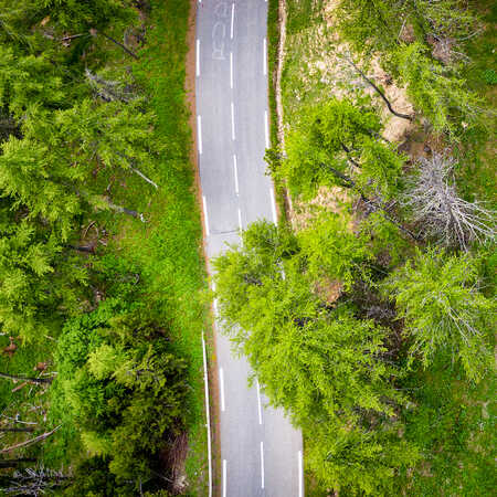
Quel itinéraire choisir sur Route des Grandes Alpes® ?
26 "tronçons" à assembler pour constituer votre itinéraire..
Route des Grandes Alpes® relie le lac Léman à la mer Méditerranée en traversant les Alpes françaises du nord au sud, pour une aventure en vélo ou VAE (vélo à assistance électrique). Sur les traces des coureurs du Tour de France, partez à l’assaut des plus beaux cols routiers , plongez au cœur de paysages grandioses et vivez un voyage inoubliable, en montagne ! Toutes les questions / réponses pour vous aider à sélectionner votre itinéraire…
Combien de kilomètres par jour ?
Comment calculer votre itinéraire .
- Faut-il préférer l’axe nord-sud ou l’axe sud-nord ?
Constituer ses propres étapes, c’est possible ?
Un week-end sur route des grandes alpes®, c’est possible , les variantes sont-elles intéressantes , peut-on éviter certains parcours moins intéressants ou plus fréquentés par les voitures .
C’est souvent la première question qui vient à l’esprit. La réponse dépend de nombreux paramètres : entraînement, habitude de parcourir de longues distances et d’enchaîner des étapes, capacité à « avaler » des dénivelés importants, de rouler en altitude, de descendre des pentes escarpées, d’éviter les pièges de la route et de la circulation, etc.
Pour toutes ces raisons, Route des Grandes Alpes® n’est pas conseillée aux néophytes. Toutes les étapes sont classées « Difficile » (couleur rouge) ou « Très difficile » (couleur noir), selon les critères du référent national produit par les ministères de tutelle qui compte 4 graduations. Heureusement, le VAE permet à un plus grand nombre (sinon au plus grand nombre) de se lancer sur l’itinéraire !
Nous avons découpé l’itinéraire principal et les variantes en 27 étapes . En réalité, il s’agit de « tronçons » calculés en fonction de l’autonomie d’un VAE et d’un parcours modéré en vélo musculaire (50 km). Après rapprochement de cette distance avec la réalité du parcours (dénivelé, hébergements et services, etc.), nous obtenons :
- 2 tronçons entre 30 et 39 km,
- 20 tronçons entre 40 et 69 kilomètres,
- 5 tronçons entre 70 et 76 km.
À vous de composer avec ce mécano routier, en fonction de votre matériel, expertise, condition physique…
Pour vous aider à préparer votre voyage, nous avons prévu un calculateur d’itinéraires , un carnet de voyage , qui est un panier dans lequel vous pourrez ranger, au fur et à mesure, vos sélections d’étapes, d’hébergements, etc.
Faut-il préférer l’axe nord-sud ou l’axe sud-nord ?
La plupart des cyclistes choisissent l'axe nord – sud. Mais, Route des Grandes Alpes® est tout aussi intéressante dans l’autre sens. Saviez-vous par exemple que les 18 000 m de dénivelé positif de l’itinéraire principal sont plus difficiles dans le sens sud – nord, car les ascensions sont plus courtes ?
Du lac Léman à la Méditerranée, ou de la Méditerranée au lac Léman, Route des Grandes Alpes®, c’est deux itinéraires totalement différents, mais d’égal intérêt.
C’est justement pour cela que nous avons raisonné « tronçons » plutôt qu’étapes ! N’hésitez pas à les couper, les assembler, les allonger, à vous écarter un peu de l’itinéraire principal… Tout au long et à proximité de Route des Grandes Alpes®, il y a suffisamment de prestataires de qualité pour vous héberger, vous nourrir, recharger votre VAE…
Vous êtes là pour vous faire plaisir, donc adaptez votre parcours !
Pas besoin d’avoir une semaine ou dix jours devant soi pour s’engager sur Route des Grandes Alpes® ! Choisissez un point de départ et un point d’arrivée avec des gares SNCF pour vous faciliter la vie. Un exemple, sur l’axe Nord-Sud ? 128 km et 4 167 m de dénivelée séparent Cluses (74) et Bourg-St-Maurice (73). Deux jours pour les gros mollets, trois pour les autres.
Même quand elle est brève, l’aventure Route des Grandes Alpes® est intense !
Il y a 6 variantes sur Route des Grandes Alpes®, disposées tout au long de l’itinéraire pour varier les paysages et les plaisirs… et parfois servir d’échappatoires, quand certains cols ne sont pas ouverts. À condition de prendre votre temps, certaines variantes permettent aussi des extensions intéressantes. Sur la variante Le Grand-Bornand (74) – Lescheraines (73), par exemple, vous pouvez réaliser la montée du Semnoz (1660 m), à partir du col de Leschaux (897 m) !
Les variantes, c’est Route des Grandes Alpes® en réalité augmentée !
En voulant vous épargner certains tronçons trop fréquentés par les voitures, nous ouvrons Route des Grandes Alpes® à d’autres itinéraires. Découvrez de nouvelles pépites !
- Exemple n°1 : la variante Val-Cenis (73) – Briançon (05). En passant par le Val de Suse, puis le col de l’Échelle (1762 m), vous profitez de l’Italie, avant d’explorer les splendeurs de la vallée de la Clarée.
- Exemple n°2 : la variante Val-Cenis (73) – Briançon (05). Après les cols de la Croix de Fer, le col du Glandon, Bourg-d’Oisans (38), nous vous proposons de continuer jusqu’à L’Alpe d’Huez (38), avant d’emprunter la route du col de Sarenne (1999 m) et de redescendre jusqu’au lac du Chambon. Une véritable expérience !
Ne croyez pas ceux qui vous disent que Route des Grandes Alpes®, c’est tout ou rien ! Sur Route des Grandes Alpes®, il y a bien des manières de tracer sa route et d’envisager son itinéraire.
Vents & Voyages
La route des Grandes Alpes® : un road-trip mythique
Avec ses 720 kilomètres entre le lac Léman et la Méditerranée, la Route des Grandes Alpes® est un itinéraire de road-trip idéal pour s’enivrer des plus beaux paysages alpins depuis sa voiture .
Depuis 1909, cette route touristique emprunte les voies secondaires et passe par 17 cols (!) de montagne parmi les plus pittoresques (et les plus hauts!) des Alpes françaises pour rejoindre les villes de Thonon-les-Bains à Nice.
Malgré mes nombreuses escapades dans les Alpes, je n’ai pas encore eu le temps de découvrir tous les tronçons de cette route. J’ai donc proposé à d’autres blogueurs de m’aider à partager avec toi quelques idées d’activités, culturelles et sportives le long de la Route des Grandes Alpes®, afin de t’aider à planifier ce superbe road-trip.
SOMMAIRE Les étapes de la Route des Grandes Alpes® Idées d’activités entre Thonon et Briançon Idées d’activités entre Briançon et Nice Informations complémentaires
Road-trip sur la Route des Grandes Alpes® : les étapes
Libre à chacun de découper cet itinéraire selon ses envies, pour le réaliser en deux jours ou en un mois. Mais si tu veux mon avis, l’idéal serait d’y consacrer deux semaines , à raison d’une cinquantaine de kilomètres de route par jour. Cela te laissera ainsi le temps de découvrir les sites historiques et culturels le long de la Route des Grandes Alpes®, mais aussi de réaliser quelques randonnées incontournables pour profiter des paysages grandioses de nos chères Alpes.
Bien sûr, tu peux aussi te limiter à la partie nord ou la partie sud, histoire d’en garder un peu pour la prochaine fois 🙂
A titre informatif, voici la liste des 17 cols sur l’itinéraire :
- col des Gets (1170 m)
- col de la Colombière (1613 m)
- col des Aravis (1486 m)
- col des Saisies (1650 m)
- Cormet de Roselend (1968 m)
- col de l’Iseran (2764 m)
- col du Télégraphe (1566 m)
- col du Galibier (2642 m)
- col du Lautaret (2057 m)
- col d’Izoard (2360 m)
- col de Vars (2108 m)
- col de la Cayolle (2326 m)
- col de la Couillole (1678 m)
- col de la Colmiane (1500 m)
- col de Turini (1604 m)
- col de Castillon (728 m)
- col d’Eze (507 m)
Les Alpes du nord : de Thonon à Briançon
Une après-midi agréable à thonon-les-bains.
Avant d’entamer ce road-trip sur la Route des Grandes Alpes ® , pourquoi ne pas en profiter pour visiter Thonon-les-Bains ? Cette ville légèrement à l’écart des itinéraires touristiques sera synonyme d’une après-midi agréable.
Si le point de départ officiel de la Route des Grandes Alpes ® est situé au château de Bellegarde, je te conseille de commencer par flâner le long de la rue piétonne pour admirer les façades savoyardes et la basilique Saint-François de Sales. Au pied de la rue Nationale, le bien-nommé Parc du Belvédère s’ouvre sur une vue splendide sur le lac Léman et la Suisse. Descends ensuite par l’ancien village de pêcheurs de Rives pour arriver au bord du lac. Le quai appelle à la promenade ou à une pause gourmande à l’un des cafés et glaciers du port de Rives. Pour remonter au centre-ville, tu peux emprunter le funiculaire, une expérience amusante ! Côté culture, le tout nouveau Pôle culturel de la Visitation a pris ses quartiers dans un ancien couvent et propose une architecture originale.
Oh, et si tu voyages avec un chien, fais le détour par l’office de tourisme : Thonon-les-Bains est labellisée « Toutourisme » et a des surprises pour les visiteurs canins !
Et si tu préfères randonner, Audrey te propose aussi un itinéraire très sympa jusqu’au Mont Forchat et sa vue panoramique sur le Léman !

L’abbaye d’Aulps
Au détour de la Route des Grandes Alpes®, une pépite culturelle t’attend à la sortie du village de Saint-Jean-d’Aulps , en direction de Thonon. Imagine les ruines d’une abbatiale du 11ème siècle, comme un décor de pierres au pied des montagnes embrumées… Ambiance gothique et mystérieuse au programme !
La visite de l’Abbaye d’Aulps permet de se balader librement dans les vestiges de l’abbatiale et dans ses jardins médicinaux et médiévaux. Ne manque pas de faire un tour au centre d’interprétation pour en savoir plus sur la vie des moines et l’histoire de l’abbaye. Des expositions d’art contemporain sont aussi proposées. Tu peux également profiter des produits locaux proposés à la tisanerie. L’abbaye d’Aulps est un incontournable pour petits et grands ! Compte une demi-journée en prenant ton temps.
Et si tu as un petit creux avant ou après la visite (ou plutôt une grosse faim), arrête-toi chez Toto, juste sur la Route des Grandes Alpes®, pour un burger aux produits savoyards accompagné d’une fritiflette. Satisfaction garantie !
Tu trouveras plein d’autres idées d’activités sur le blog d’Hélène et Paule-Elise – 1916 kilomètres

Moyen-Âge et art contemporain à Taninges
Lové au pied du Marcelly, le bourg de Taninges offre une petite halte sympathique le long de la Route des Grandes Alpes® . Avec ses maisons fortes et sa chartreuse de Mélan, la petite cité du Faucigny dispose d’un patrimoine honorable au regard de sa taille.
Le cœur historique du village se concentre autour de la place du marché. Il ne te faudra pas plus d’un quart d’heure pour en arpenter ses plus beaux lieux : le pont sur le Foron et la rue des Arcades. Un peu à l’écart du centre bourg, la chartreuse de Mélan constitue le principal point d’intérêt de Taninges. Si une grande partie des bâtiments datant du Moyen Age ont été détruits dans un dramatique incendie en 1967, l’église et le cloître de style gothique ogival sont encore debout. Aujourd’hui, la chartreuse accueille un centre d’art contemporain qui propose régulièrement des expositions temporaires. Tu pourras également admirer certaines œuvres permanentes dans le parc attenant. Deux heures top chrono suffisent pour visiter village et chartreuse.
Il te reste encore un peu de temps avant de reprendre la route? N’hésite pas à faire un tour à Taninges Télécabines. Ce brocanteur s’est spécialisé dans les télécabines vintage.
Tu trouveras plein d’autres idées d’activités et de randonnées sur le blog de Delphine – In Rando Veritas

Le Beaufortain: Randonnée autour de la Legette depuis le col des Saisies
Le col des Saisies accueille la station de ski éponyme. Sa situation géographique la rend très agréable et très ensoleillée et est un arrêt incontournable lors d’un road-trip sur la Route des Grandes Alpes®.
Au départ du col des Saisies, je te conseille de stationner au parking pour faire la randonnée qui suit l’itinéraire balisé du Trail du Chard (itinéraire n°22 balisé en bleu). Cette dernière permet de réaliser une boucle d’une dizaine de kilomètres offrant des vues magnifiques sur la vallée du Beaufortain, puis se termine en apothéose avec le Balcon sur le Mont Blanc, une structure en bois aménagée au niveau du sommet du sommet du Chard du Beurre, offrant d’un côté une vue époustouflante sur le Mont Blanc et de l’autre une vue imprenable sur le Massif des Aravis . Bien entendu, tu n’es pas obligé de courir pour suivre l’itinéraire 🙂 En marchant, compte entre 2h30 et 3h pour compléter la boucle.
Si le temps t’est compté ou si la randonnée n’est pas ton truc, sache que tu peux facilement atteindre le Balcon sur le Mont Blanc via le télésiège du Chard du Beurre. Tu peux ensuite regagner le parking du Col des Saisies à pied ou redescendre également en télésiège.
Pour en savoir plus sur cette belle randonnée et les activités à faire aux Saisies, je t’invite à consulter l’article de Mathilde sur les Saisies .

Le Beaufortain: Randonnée au refuge de Presset depuis le Cormet de Roselend
Et si tu garais ta voiture pour te dégourdir les jambes ? Je te propose une superbe randonnée, un grand classique du massif du Beaufortain .
Au départ du parking du Cormet de Roselend, le col routier reliant Beaufort à Bourg-Saint-Maurice, endosse ton à sac à dos, chaussures et affaires courantes pour te rendre au refuge de Presset, sur un sentier balisé et facile à marcher.
Compte 2h30 à 3h pour t’y rendre et 700 mètres de dénivelé positif avec notamment l’ascension du col du Grand Font à 2671m, qui te donne une meilleure vue, à la fois sur la Pierra Menta, le refuge de Presset et son lac.
Le refuge est apprécié pour son confort et est une position idéale pour admirer un lever de soleil sur la Pierra Menta , un monolithe à 2714 mètres d’altitude qui donne son nom à une prestigieuse course de ski alpinisme.
Pour en savoir plus sur cette belle randonnée, je t’invite à consulter l’article d’Emmanuel sur sa randonnée de 2 jours dans le Beaufortain .

La Vanoise: Randonnée autour des sommets à 3000m depuis l'Iseran
Le départ de cette randonnée d’envion 3h30, se situe quelques kilomètres après le col de l’Iseran en direction de Bonneval sur Arc, au lieu dit Pont de neige. Le chemin s’élève en direction du col de fours. On chemine à l’emplacement d’un ancien glacier, à 2500m d’altitude. La neige est présente souvent bien longtemps à proximité.
L’itinéraire proposé sort ensuite du sentier principal. Sans présenter de difficultés, il faut toutefois savoir se diriger en montagne, sur des sentiers peu tracés. Avant d’arriver au lac de l’ancien glacier du fond, il faut prendre la direction de la pointe de la Met. L’itinéraire est peu pratiqué, et tu seras très certainement seul, procurant une belle ambiance de montagne . On chemine au travers une ancienne moraine, un gros tas de cailloux !
Le sommet est atteint facilement et offre un panorama fabuleux ! Premier 3000m du jour, avec une altitude de 3050m . Ensuite, on continue le tour de ce petit cirque en rebroussant chemin en direction de la pointe sud de Bézin, à 3020m. Tu peux ensuite poursuivre vers la pointe nord de Bézin, avant de rejoindre le lac de l’ancien glacier du fond, puis redescendre vers le point de départ.
J’ai beaucoup aimé cette randonnée pour son côté sauvage, sa vue splendide sur la Vanoise et son côté montagne tout en restant facile . Les collectionneurs de sommets se feront plaisir avec trois 3000m d’un coup!
Pour en savoir plus sur cette belle randonnée, je t’invite à consulter l’article de Virginie sur sa randonnée autour des sommets à 3000m .

Les Ecrins: le jardin du Lautaret
Perché à plus de 2000 mètres d’altitude, le jardin du Lautaret invite à la découverte des plantes de montagne depuis plus de 100 ans.
Des milliers d’espèces venues du monde entier sont ainsi présentées aux visiteurs, qui viennent les découvrir entre juin et septembre. Bien plus qu’un simple jardin, il participe activement à la conservation et la préservation de cette biodiversité si fragile , œuvrant à de nombreux projets scientifiques en France et à travers le monde. Arbres centenaires, espèces en voie de disparition, cours d’eau bordés de fleurs colorées et vue unique sur les glaciers de la Meije… tu ne seras pas déçu !
Prévois une ou deux heures pour arpenter les sentiers du jardin et n’hésite pas à te joindre aux visites guidées organisées quotidiennement par des étudiants passionnés.
Tu trouveras plein d’autres idées d’activités sur le blog de Charly – Charly Far Away

Les Cerces: Randonnée au col de la Ponsonnière par le Grand Lac
Au niveau du parking de l’Auberge du Pont de l’Alp, une magnifique randonnée te permettra d’atteindre l’un des plus beaux points de vue de la région . Je nomme le col de la Ponsonnière !
Cette boucle de 13.5km et un peu plus de 900m de dénivelé positif te mènera tout d’abord au magnifique Grand Lac au pied du col de la Ponsonnière. Je vois déjà tes yeux qui brillent en arrivant devant ce décor de carte postal, mais le meilleur reste à venir !
Après une belle grimpette jusqu’au col, tu profiteras de ta pause pour contempler sans te lasser le panorama qui s’offre devant, mais aussi derrière toi. D’un côté la géante des Ecrins, la Meije, nous observe de ses reliefs abruptes. De l’autre, tes yeux se perdront au milieu des sommets de la Vanoise et dans le fond, le massif du Mont Blanc.
Une randonnée incontournable pour un souvenir impérissable !
Pour en savoir plus sur cette belle randonnée, je t’invite à consulter la dernière étape décrite dans mon article sur le tour du Thabor et des Cerces

Les Ecrins: Randonnée au lac de l'Eychauda
Depuis le village de Monêtier-les-Bains, je te propose de découvrir l’une des plus belles randonnées dans le parc national des Ecrins . L’avantage de cette randonnée c’est que si tu ne te sens pas de réaliser les 15km et 1500m de dénivelé positif, tu pourras emprunter le télésiège du Monêtier pour t’éviter trop d’effort.
En effet, à l’arrivée du télésiège il ne te reste que 900m d’ascension jusqu’au col des Grangettes et sa superbe vue sur le lac de l’Eychauda en contrebas. Attention toutefois, la dernière centaine de mètres jusqu’au col est un peu périlleuse, très étroite avec quelques passages vertigineux à l’aide de mains courantes. Cela nécessite d’avoir le pied sûr. Je déconseille donc cette randonnée aux enfants et personnes sujettes aux vertige.
Le retour se fait sans peine par le vallon qui longe le torrent du Grand Tabuc avant de rejoindre le Monêtier.
Pour en savoir plus sur cette belle randonnée, je t’invite à consulter l’étape 4 décrite dans mon article sur le tour des Ecrins

Découverte de la cité Vauban de Briançon
Lors de ton road-trip sur la Route des Grandes Alpes® , une visite de Briançon s’impose, pour une promenade culturelle ou nature . En effet, impossible de ne pas découvrir la cité Vauban et ses forts alentour !
Renforcée par Vauban pour se protéger de l’Italie, l’ancienne cité médiévale, s’est agrandie de remparts et bastions saillants pentagonaux . N’hésite pas à aller admirer les vues sur la vallée de Serre Chevalier d’où tu es arrivé, puis sur la vallée de Briançon. En se promenant dans la vieille ville aux façades colorées, la collégiale se découvre au coin d’une ruelle. Puis, attention à ne pas te mouiller les pieds dans la Grande Gargouille, la ruelle traversée par son petit canal ouvert, créé au Moyen-âge pour empêcher les feux dans la cité.
Tu peux ensuite sortir de la cité et rejoindre le pont d’Asfeld, un magnifique ouvrage s’élevant à 60 m, au-dessus de la Durance qui permet de relier un autre fort Vauban : le fort des Têtes.
Pour retrouver la nature, tu peux monter au fort des Salettes puis à la Croix de Toulouse soit par une belle randonnée soit par la via ferrata pour les plus sportifs.
Tu trouveras plus d’informations pour visiter Briançon et les Hautes Alpes sur le blog de Sandrine – Experiences Hautes Alpes

Les bons plans ! -> Réserve tes hébergements au meilleur prix -> Tous les itinéraires de randonnées dans les Alpes -> D’autres idées d’activités et excursions le long de la Route des Grandes Alpes -> Excursions depuis Nice
Les Alpes du sud : de Briançon à Nice
Le queyras : randonnée au col de porte depuis le col de l'izoard.
Le paysage lunaire et désertique du col de l’Izoard est l’un des plus pittoresque que tu rencontreras le long de ce road-trip sur la Route des Grandes Alpes®. Et pour en profiter encore plus, je te propose de réaliser l’ascension jusqu’au col de Porte à travers un immense pierrier !
Dis comme ça, ça fait rêver, non?
Cet aller-retour de 9km et 750m de dénivelé positif te permettra de t’imprégner de l’ambiance et l’atmosphère si particulière de ce décor aride. L’ascension au col n’est pas compliquée si ce n’est que les cailloux et les rochers limitent fortement la progression. Pense à prévoir un peu plus de temps qu’à ton habitude.
Depuis le col de Porte, un panorama incroyable se dévoile sous tes pieds. J’ai personnellement une petite préférence pour le panorama sur les glaciers des Ecrins plutôt que celui sur le massif du Queyras, mais tout est question de goût.
Si tu as encore un peu de jus dans les jambes et que tu n’as pas peur de grimper dans les rochers, tu peux poursuivre jusqu’au pic de Rochebrune, 300m plus haut avant de revenir sur tes pas jusqu’au parking.
Pour d’autres idées de randonnées dans le Queyras, je t’invite à consulter mon article sur les plus belles randonnées du Queyras .

Visiter Mont-Dauphin, la place forte Vauban inscrite à l'UNESCO
Surplombant le Guil, sur le plateau désert des Millaures, la place forte de Mont-Dauphin est un bijou architectural et historique qui mérite sans nul doute un arrêt lors de ton road-trip sur la Route des Grandes Alpes®.
Afin d’apprendre tous les secrets de ce site culturel, je te conseille fortement de réserver une visite guidée. Cela te permettra de faire le tour des remparts pour profiter de la vue incroyable sur tous les sommets environnants mais aussi découvrir toute l’ingéniosité de Vauban dans la construction de cette place forte.
Et pour prolonger l’expérience, tu peux même dormir au Pavillon des Officiers, réhabilité en hôtel pour les touristes, mais en ayant gardé tout le cachet du bâtiment historique. Testé et recommandé par mes soins 🙂

Le Mercantour: de la vallée de la Vésubie au col de Turini
Située au pied des plus hauts sommets du parc national du Mercantour et de la renommée vallée des Merveilles, la vallée de la Vésubie est considérée comme l’une des plus belles vallées de l’arrière-pays niçois .
Ici les activités ne manquent pas, et nombreux sont les touristes qui s’y posent plus d’une journée avant de continuer vers Nice.
Les plus intrépides s’arrêteront au col de la Colmiane pour s’aventurer sur la plus grande tyrolienne de France ! Les plus sportifs iront randonner dans le Mercantour , ou feront du canyoning dans les gorges de la Vésubie. Et si le temps n’est pas de la partie, ils pourront toujours se défouler au Vésubia Mountain Park ! Pour se relaxer, c’est au spa des thermes de Berthemont que tu trouveras ton bonheur. Enfin, les amoureux des animaux ne manqueront pas d’aller découvrir le parc alpha et ses loups.
Pour te loger, je te conseille le Camping Les Templiers et sa position centrale dans la vallée pour naviguer entre les différents points d’intérêt.
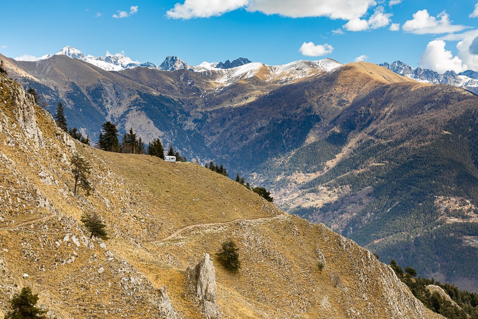
Visiter Menton en une journée
Capitale du citron, Menton est une étape incontournable de la Route des Grandes Alpes ® .
Cette ville gorgée de soleil se visite facilement à pied en une journée. Le vieux Menton est l’une des parties les plus charmantes de la ville. Ce labyrinthe de rues étroites et de maisons colorées te conduit dans un premier temps jusqu’à la Basilique Saint-Michel Archange.
N’hésite pas à emprunter ces escaliers d’un jaune flamboyant qui conduisent jusqu’au front de mer. Le tableau que l’on observe au pied des escaliers est tout simplement splendide. Flâne dans les ruelles de la perle de la rivière jusqu’au cimetière du Vieux- Château où tu profiteras d’une vue imprenable sur toute la baie de Menton. Ne manque pas le magnifique Jardin botanique Val Rahmeh et sa flore tropicale ! Pour découvrir la vue la plus représentative de Menton sur les réseaux sociaux, rends-toi au bout du quai impératrice Eugénie. La balade en vaut la chandelle.
Tu trouveras plein d’autres conseils pour visiter cette belle région sur le blog d’Erika – ErikaVoyage

Roquebrune-Cap-Martin: Randonnée sur le sentier des douaniers
Depuis la gare de Roquebrune-Cap-Martin, nous avons pu faire la randonnée du sentier des douaniers qui longe le littoral entre Monaco et Menton .
D’une durée de 3 heures environ et sans aucune difficulté particulière hormis un peu de dénivelé positif (D+150) nous avons pu emprunter ce célèbre chemin de randonnée qui passe devant le cabanon du Corbusier et de la villa E-1057 d’Eileen Gray.
Cette randonnée mêlant chemin de terre et route asphaltée, nous a conduit directement sur les hauteurs de la ville. De là, nous avons pu voir l’olivier millénaire le plus vieux de France ainsi que le château médiéval. Les petites ruelles du vieux village sont pleines de charme et permettent d’avoir un peu d’ombre lors des journées ensoleillées de la côte.
Pour en savoir plus sur cette belle randonnée, je t’invite à consulter l’article de Christophe et Sandrine sur leurs itinéraires de visites à Monaco .

Saint-Jean-Cap-Ferrat
A quelques kilomètres de la Grande Corniche (D2564) qui relie Roquebrune-Cap-Martin à Nice se trouve l’un des trésors de la Côte d’Azur, la presqu’île de Saint-Jean-Cap-Ferrat . C’est l’un des mes endroits préférés du littoral et nous y allons régulièrement été comme hiver.
Les amateurs de randonnée ne manqueront pas de faire le tour complet de Saint-Jean-Cap-Ferrat sur l’agréable sentier du littoral. L’itinéraire facile (10 km et 160 m de dénivelé) est accessible à toute la famille.
Pour ceux qui préfèrent le farniente, la presqu’île abritent certaines des plages les plus belles de la Côte d’Azur, dont la plus célèbre est Paloma. Les fonds marins sont également très riches ce qui permet de pratiquer le snorkeling.
Et côté culture ne manque pas la superbe villa Ephrussi de Rothschild, un palais de style Renaissance aux magnifiques jardins.
Pour en savoir plus sur les activités, je t’invite à consulter l’article de Nicolas sur la presqu’île de Saint-Jean-Cap-Ferrat .

Informations pratiques
La bonne période pour réaliser ce road-trip est en entre fin mai et fin octobre. Déjà pour des raisons pratiques, c’est mieux quand tous les cols sont déneigés et accessibles en voiture. Mais aussi parce que c’est la saison pour réaliser les randonnées !
Si ce road-trip sur la route des Grandes Alpes® peut en toute logique se réaliser en voiture, tu peux aussi entreprendre cette aventure en camping-car, en moto ou à vélo.
Aparté à l’attention des conducteurs de voitures: cette route touristique est très fréquentée par les motos et les cyclistes. Tu devras donc composer avec tes collègues sur les petites routes à lacet. Oui, parfois c’est chiant de suivre un cycliste à 10km/h sur la route qui monte au col sans possibilité de le doubler, mais on fait avec et surtout on ne met pas en danger la sécurité des autres usagers de la route !
Si tu n’aimes pas ça, alors il vaut mieux pour tout le monde abandonner l’idée de ce road-trip.
Tu trouveras de très nombreux logements sur tout l’itinéraire, de l’hôtel 5*, au camping, en passant par certains refuges ou gites de groupe.
Si l’option camping sauvage ou bivouac te tente (héhé, tu l’as?), pense à vérifier la réglementation dans les zones que tu traverses. Et surtout, ne laisse aucune trace de ton passage.
En début et fin d’été, les conditions météos peuvent vite évoluer notamment concernant la neige et l’ouverture / fermeture des cols.
En mai-juin, je te conseillerais donc de plutôt commencer par le sud pour remonter à Thonon, et l’inverse en septembre-octobre.
J’espère que cet article et tous ces conseils de blogueurs t’auront donné envie de réaliser ce road-trip sur cette magnifique route panoramique alpine qu’est la route des Grandes Alpes® !
Epingle-moi sur Pinterest !

Pour améliorer l'expérience utilisateur le site Vents & Voyages collecte des cookies et traite les données personnelles collectées à des fins statistiques. Le fait de ne pas consentir ou de retirer son consentement peut avoir un effet négatif sur certaines caractéristiques et fonctions.
Route des Grandes Alpes is a lifetime driving experience
How long is route des grandes alpes, when was route des grandes alpes built, is route des grandes alpes paved.
Is Route des Grandes Alpes open?
Mountain passes of route des grandes alpes:, how long does it take to drive the route des grandes alpes.
Is Route des Grandes Alpes worth it?
Route Des Grandes Alpes – 7 days, 682km, 16 climbs
What is ‘Route Des Grandes Alpes’?
An amazing fully-supported cycling tour taking you from Lake Geneva to Menton on the Cote d’Azur, France.
How long is the route?
The route covers 682 km, 16 climbs, over 17,800m elevation gained.
When does it take place?
There are 2 available dates:
- 22 Jul – 29 Jul
- 26 Aug – 02 Sep
What is included?
- Airport transfers
- Ensuite Accommodation in 2-star or 3-star hotels
- Continental or Buffet breakfast & evening meals with wine, beer or soft drink
- Snacks, energy gels and bars during the rides
- Water and electrolyte tablets
- Maps and GPS files
- Owayo “Route des Grandes Alpes” jersey
You’ll be met at Geneva airport and taken to the hotel at Amphion-les-Bains, right next Lake Geneva.
D1: Lake Geneva – Flumet (118km)
The journey begins with a ride from Lake Geneva, passes through Col des Gets, Col de la Colombière and the final climb of the day is Col d’Aravis, descent and a short ride to Flumet.
D2: Flumet – Val d’Isère (105km)
The second day stars with a climb: Col des Saisies then the route passes through Cormet de Roselend and the last climb is up to Val d’Isère.
D3: Val d’Isère – Monêtier-les-Bains (150km)
Day 3 begins with yet another epic climb: Col de l’Iseran, before nearly 70km of descent until you reach the foot of the Col du Télégraphe. After a short descent you’ll climb Col du Galibier and descend into Monêtier-les-Bains for the night.
D4: La Salle les Alpes – Barcelonnette (100km)
The day will start with 9km descent into Briançon before hitting the foot of Col d’Izoard, then you start a 30km descent, through a very rocky landscape passing through a number of picturesque small ski resorts. The second and last climb of the day is Col de Vars, a 20km ascend with 11% sections.
Day 4 is when you’d have the opportunity to ride up Cime de la Bonette, if you wanted to or go straight to hotel after the second decent.
D5: Barcelonnette – Saint-Martin-Vésubie (134km)
The penultimate day of the tour starts by climbing Col de la Cayolle, passes through the milder Col de Valberg and Col de la Couillole. And the last climb of the day will take you to the top of Col de Saint Martin, just before the ski resort of Valdeblore and then you’ll descend to Saint-Martin-Vésubie where you’d spend the night.
D6: Saint-Martin-Vésubie – Menton (75km)
The last day of Route Des Grandes Alpes starts with a short descent and a gentle climb up Col de la Couillole, following is Col de Saint Martin, Col de Turini and through the last climb up Col de Castillon. From there it’s a descent all the way to Menton for a well deserved celebration.
You will be transferred to Nice airport.
How much does it cost? From only £1300 (shared room). Single rooms are also available.
Privacy Overview

Route des Grandes Alpes mit dem Motorrad oder Auto
Route des grandes alpes, der pässe-klassiker in den französischen alpen, wo beginnt und endet die route des grandes alpes welche alpenpässe in frankreich werden dabei befahren wo finde ich den genauen streckenverlauf der route des grandes alpes mit allen pässen und wichtigen wegpunkten auf einer karte von google maps sowie als route zum download für mein navi und was muss ich bei der befahrung der route des grandes alpes mit dem motorrad oder auto beachten antworten zu diesen fragen sowie tipps und fotos gibt’s hier auf pässe.info..
Die Route des Grandes Alpes verbindet Thonon-les-Bains am Genfersee mit Menton am Mittelmeer und ist nebst der Route Napoleon der Klassiker der französischen Alpenrouten. Diese asphaltierte Alpenroute ist rund 685 Kilometer lang und führt über 21 Pässe, darunter einige der bekanntesten und schönsten der Französischen Alpen wie Colombière, Aravis, Roselend, Iseran, Galibier, Izoard, Vars, Cayolle, Valberg, Couillole oder Turini.
Manche Quellen zählen auf dieser französischen Alpenroute nur 16 Alpenpässe, weil sie die Pässe Col du Châtillon-sur-Cluses, Col de Saint-Jean-de-Sixt, Méraillet (am Lac de Roselend), Col de la Madeleine (auf der Route de l'Iseran und nicht zu verwechseln mit dem bekannten und wichtigen Alpenpass Col de la Madeleine in der Nähe von Albertville) und Lautaret (am Fusse des Galibiers) weglassen. Über den Col du Lautaret führt sogar eine wichtige Verbindungsstrasse in den Süden und nach Italien, wobei der Lautaret auf der Route des Grandes Alpes nur auf der Südseite befahren wird.
Routenlänge Route des Grandes Alpes
Ca. 685 km beträgt die Gesamtstrecke der Route des Grandes Alpes zwischen Thonon-les-Bains und Menton über 21 Alpenpässe und gefühlte 10'000 Kurven
Fahrzeiten Route des Grandes Alpes mit dem Motorrad
Plus/minus 18 Stunden reine Fahrzeit benötigt man für die Gesamtstrecke der Route des Grandes Alpes. Man sollte für die knapp 700 Kilometer lange Alpenroute drei bis vier Tage einplanen. Sonst hat man keine Zeit für die wirklich lohnenswerten Pausen. Alpenerfahrene Zügigfahrer:innen ohne Hang nach vielen Pausen schaffen die Strecke in zwei Tagen. Die Route des Grandes Alpes mit dem Motorrad an einem Tag ist möglich: Mitte Juni bis Mitte Juli bei durchgehend trockenen Strassen mit geeignetem Motorrad und Abfahrt vollständig ausgeruht und fit in der Frühe. Aber Spass ist ab dem letzten Drittel der Strecke definitiv was anderes!
Fahrzeit Route des Grandes Alpes mit dem Auto
Die Route des Grandes Alpes ist auch mit dem Auto befahrbar und mit dem Cabrio wegen der uneingeschränkten Rundumsicht in oft traumhafte Landschaften ein besonderer Genuss. Mit dem Auto fährt man aber deutlich länger, auch weil in den manchmal engen Strassen für Autos oft kein Überholen möglich ist. Dafür ist auf dieser Alpenroute das Auto/Cabrio bei der Erstbefahrung wegen den vielen Foto- und Besichtigungspausen deutlich komfortabler. Fünf Tage sind für die ganze Strecke in diesem Fall ideal. Wohnmobile können Teilstrecken zwar befahren, weichen aber besser auf die ebenfalls attraktive Route Napoleon aus.

Die Route des Grandes Alpes führt über 21 Alpenpässe, darunter einige der bekanntesten und schönsten Pässe der Französischen Alpen.
Streckenlänge ca. 685 km
Die 21 pässe der route des grandes alpes.
- 1172 - F - Col des Gets
- 0742 - F - Col du Châtillon-sur-Cluses
- 1613 - F - Col de la Colombière
- 0956 - F - Col de Saint-Jean-de-Sixt
- 1487 - F - Col des Aravis
- 1650 - F - Col des Saisies
- 1605 - F - Col du Méraillet
- 1968 - F - Cormet de Roselend
- 2770 - F - Col de l'Iseran
- 1746 - F - Col de la Madeleine (Route de l'Iseran)
- 1566 - F - Col du Télégraphe
- 2642 - F - Col du Galibier
- 2058 - F - Col du Lautaret
- 2360 - F - Col d'Izoard
- 2109 - F - Col de Vars
- 2326 - F - Col de la Cayolle
- 1672 - F - Col de Valberg
- 1678 - F - Col de la Couillole
- 1500 - F - Col Saint Martin
- 1607 - F - Col de Turini
- 0706 - F - Col de Castillon

Karte Route des Grandes Alpes, ca. 685 km.
© Pässe.Info, Karte Google Maps
→ Online-Karte mit Track auf Google Maps weiter unten

Höhenprofil Route des Grandes Alpes von Nord (Thonon-les-Bains) nach Süd (Menton).

Günstiges Hotel auf der Route des Grandes Alpes in Frankreich gesucht?
Pässe.Info als Partner von Booking.com erhält bei Buchungen einen Beitrag an die Unterhaltskosten, wenn die Suche via Pässe.Info gestartet wurde – bei identischen Preisen inkl. Vergünstigungen für Genius-Kunden!
► Booking-Seite auf Pässe.Info für günstige Hotels und Übernachtungen auf der Route des Grandes Alpes in Frankreich
► direktlink zu booking.com, track der ganzen strecke, karte route des grandes alpes auf google maps.
Anzeige Route des Grandes Alpes mit Track und Wegpunkten direkt in Google Maps (Browser oder App).
Tour für Motorrad und Auto
Download route des grandes alpes für gps-navigation.
Route des Grandes Alpes mit allen Pässen und hilfreichen Wegpunkten von Pässe.Info
Update 16.05.2023
Route des grandes alpes gpx.
Garmin, BMW Motorrad Navigator, TomTom (MyDrive) etc.
Route des Grandes Alpes ITN
TomTom (zum Kopieren für Geräte ohne MyDrive)
Die Alpenrouten Nord-Süd und Süd-Nord enthalten die gleichen Pässe und sind von der Strecke her praktisch identisch. Unterschiedlich sind zusätzlich manuell gesetzte Wegpunkte bei Abzweigungen, die man in dieser Fahrtrichtung leicht verpasst.

BMW Motorrad Navigator V mit installierter Route des Grandes Alpes von Pässe.Info.

Achtung: Die Zeitberechnung der Alpenrouten ist bei den meisten Navis bei Pässen mit vielen engen Kurven etwas zu optimistisch. Für einige Pässe der Route des Grandes Alpes wird für die meisten Fahrer:innen mehr Zeit benötigt. Man sollte für die ganze Strecke 18 Stunden Fahrzeit einplanen.
Hinweise zu Abbiegungen auf der Route des Grandes Alpes
2 abzweigungen, die man leicht übersieht und verpasst, hinweis linksabbiegen von pässe.info in fahrtrichtung nord, in richtung genfersee auf der route des grandes alpes bleiben.

Die Route des Grandes Alpes ist an vielen Stellen ungenügend ausgeschildert und man fährt idealerweise mit GPS und Karte. Reist man von Süd nach Nord, darf man in der Talstrecke nach Saint-Sauveur-sur-Tinée eine unscheinbare Linksabbiegung nicht verpassen, sonst landet man auf dem Col de la Bonette, der nicht zur Route des Grandes Alpes zählt.
Hinweis Linksabbiegen von Pässe.Info in Fahrtrichtung Süd
In richtung mittelmeer auf der route des grandes alpes bleiben.

Fährt man die Route des Grandes Alpes von Nord nach Süd, verpasst man auf der Route de la Vésubie leicht die Abzweigung nach links Richtung Col de Turini. Man kommt dann via Nizza auch nach Menton, verpasst dann aber die legendären Kurven der Monte-Carlo-Rally.
Fotos und Infos
Frankreich (route des grandes alpes), 1172 m, col des gets.

Col des Gets, 1172 m, Frankreich: Der 1. Alpenpass der Route des Grandes Alpes (in Richtung Nord nach Süd).
Frankreich (Route des Grandes Alpes), 742 m
Col du châtillon-sur-cluses.

Col du Châtillon-sur-Cluses, 742 m, Frankreich: Der 2. Alpenpass der Route des Grandes Alpes (in Richtung Nord nach Süd).
Frankreich (Route des Grandes Alpes), 1613 m
Col de la colombière.

Col de la Colombière, 1613 m, Frankreich: Der 3. Alpenpass der Route des Grandes Alpes (in Richtung Nord nach Süd).
Frankreich (Route des Grandes Alpes), 956 m
Col de saint-jean-de-sixt.

Col de Saint-Jean-de-Sixt, 956 m, Frankreich: Der 4. Alpenpass der Route des Grandes Alpes (in Richtung Nord nach Süd). Er wird in anderen Quellen nicht als Pass der Route des Grandes Alpes bezeichnet, obwohl er auf der offiziellen Wegstrecke liegt.
Frankreich (Route des Grandes Alpes), 1487 m
Col des aravis.

Col des Aravis, 1487 m, Frankreich: Der 5. Alpenpass der Route des Grandes Alpes (in Richtung Nord nach Süd).
Frankreich (Route des Grandes Alpes), 1650 m
Col des saisies.

Col des Saisies, 1650 m, Frankreich: Der 6. Alpenpass der Route des Grandes Alpes (in Richtung Nord nach Süd).
Frankreich (Route des Grandes Alpes), 1605 m
Col du méraillet.

Col du Méraillet, 1605 m, Frankreich: Der 7. Alpenpass der Route des Grandes Alpes (in Richtung Nord nach Süd). Er wird in anderen Quellen nicht als Pass der Route des Grandes Alpes bezeichnet, obwohl er auf der offiziellen Wegstrecke liegt.
Frankreich (Route des Grandes Alpes), 1968 m
Cormet de roselend.

Cormet de Roselend, 1968 m, Frankreich: Der 8. Alpenpass der Route des Grandes Alpes (in Richtung Nord nach Süd).
Frankreich (Route des Grandes Alpes), 2770 m
Col de l'iseran.

Col de l'Iseran, 2770 m, Frankreich: Der 9. Alpenpass der Route des Grandes Alpes (in Richtung Nord nach Süd).
Frankreich (Route des Grandes Alpes), 1746 m
Col de la madeleine (route de l'iseran).

Col de la Madeleine (Route de l'Iseran), 1746 m, Frankreich: Der 10. Alpenpass der Route des Grandes Alpes (in Richtung Nord nach Süd). Er wird in anderen Quellen nicht als Pass der Route des Grandes Alpes bezeichnet, obwohl er auf der offiziellen Wegstrecke liegt.
Frankreich (Route des Grandes Alpes), 1566 m
Col du télégraphe.

Col du Télégraphe, 1566 m, Frankreich: Der 11. Alpenpass der Route des Grandes Alpes (in Richtung Nord nach Süd).
Frankreich (Route des Grandes Alpes), 2642 m
Col du galibier.

Col du Galibier, 2642 m, Frankreich: Der 12. Alpenpass der Route des Grandes Alpes (in Richtung Nord nach Süd).
Frankreich (Route des Grandes Alpes), 2058 m
Col du lautaret.

Col du Lautaret, 2058 m, Frankreich: Der 13. Alpenpass der Route des Grandes Alpes (in Richtung Nord nach Süd). Er wird in anderen Quellen nicht als Pass der Route des Grandes Alpes bezeichnet, obwohl er auf der offiziellen Wegstrecke liegt. Auf der Route des Grandes Alpes wird er nur auf der Südrampe befahren. Das heisst: ab Passhöhe des Col du Lautaret geht's weiter zum Col du Galibier.
Frankreich (Route des Grandes Alpes), 2360 m
Col d'izoard.

Col d'Izoard, 2360 m, Frankreich: Der 14. Alpenpass der Route des Grandes Alpes (in Richtung Nord nach Süd).
Frankreich (Route des Grandes Alpes), 2109 m
Col de vars.

Col de Vars, 2109 m, Frankreich: Der 15. Alpenpass der Route des Grandes Alpes (in Richtung Nord nach Süd).
Frankreich (Route des Grandes Alpes), 2326 m
Col de la cayolle.

Col de la Cayolle, 2326 m, Frankreich: Der 16. Alpenpass der Route des Grandes Alpes (in Richtung Nord nach Süd).
Frankreich (Route des Grandes Alpes), 1672 m
Col de valberg.

Col de Valberg, 1672 m, Frankreich: Der 17. Alpenpass der Route des Grandes Alpes (in Richtung Nord nach Süd). Gewisse Quellen führen ihn nicht als Pass der Route des Grandes Alpes auf, wobei er von der Wegführung her durchaus als Pass betrachtet werden muss.
Frankreich (Route des Grandes Alpes), 1678 m
Col de la couillole.

Col de la Couillole, 1678 m, Frankreich: Der 18. Alpenpass der Route des Grandes Alpes (in Richtung Nord nach Süd).
Frankreich (Route des Grandes Alpes), 1500 m
Col saint martin.

Col Saint Martin, 1500 m, Frankreich: Der 19. Alpenpass der Route des Grandes Alpes (in Richtung Nord nach Süd).
Frankreich (Route des Grandes Alpes), 1607 m
Col de turini.

Col de Turini, 1607 m, Frankreich: Der 20. Alpenpass der Route des Grandes Alpes (in Richtung Nord nach Süd). Gleich drei Strassen führen zum von der Monte-Carlo-Rally her bekannten Turini. Fährt man die Route des Grandes Alpes von Süd nach Nord, darf man nicht die nach links abbiegende Strasse erwischen – sonst geht's wieder zurück ans Meer in Richtung Nizza. Die von Sospel herführende Strasse mit ihren vielen Spitzkehren ist am herausfordernsten.
Frankreich (Route des Grandes Alpes), 706 m
Col de castillon.

Col de Castillon, 706 m, Frankreich: Der 21. Alpenpass der Route des Grandes Alpes (in Richtung Nord nach Süd). Die eigentliche Passhöhe kann nicht überfahren werden. Für die Passage gibt es zwei Tunnels, wobei der kürzere Tunnel mit der offiziellen Passtafel beschildert ist.
Tourempfehlung von Pässe.Info
Route des grandes alpes und route napoleon als grosse rundtour in den französischen alpen.
Als abwechslungsreiche Rundtour mit dem Motorrad in den Französischen Alpen bietet sich die Kombination der Route des Grandes Alpes mit der Route Napoleon an.
Pässe.Info empfiehlt – nicht nur aus historischen Gründen – zuerst die Route des Grandes Alpes von Nord nach Süd (also von Thonon-les-Bains nach Menton) zu befahren. Von da aus fährt man nach Cannes und erreicht über die Route Napoleon auf meist breiten und sehr gut ausgebauten Strassen wieder den Genfersee.
Mehr Infos, Karte mit der genauen Wegstrecke der Route Napoleon sowie GPS-Route zum Download auf Pässe.Info unter Motorradtouren auf der Seite Route Napoleon .

IMPRESSUM | DATENSCHUTZ | SITEMAP
© Pässe.Info Thomas Haefliger
- Nach oben scrollen
Routes des Grandes Alpes

Die GPS-Daten zu diesen Touren finden Sie unten als Download: • Etappe 1: Zwei Pässe zum Auftakt (88 km, 2.000 hm, max. 10 Prozent Steigung) • Etappe 2: Die Königsetappe (127 km, 3.797 hm, max. 10 Prozent Steigung) • Etappe 3: Das Dach der Tour (105 km, 1.920 hm, max. 8 Prozent Steigung) • Etappe 4: Die Klassiker: Galibier und Izoard (103 km, 2.420 hm, max. 14 Prozent Steigung) • Etappe 5: Nacht in dünner Luft (78 km, 2.240 hm, max. 10 Prozent Steigung) • Etappe 6: Heißer Asphalt der Seealpen (104 km, 2.250 hm, max. 8 Prozent Steigung) • Etappe 7: Triumphfahrt ans Meer (72 km, 1.470 hm, max. acht Prozent Steigung)
Den gesamten Artikel über die Route des Grandes Alpes sowie die GPS-Daten finden Sie unten als Download.
GPS-DATEN: TOUR bietet die Daten der Touren zum kostenlosen Download an. Die Tracks im GPX-Format können Sie zum Nachfahren direkt auf ein GPS-Gerät laden oder am Computer in Google Earth oder Google-Maps betrachten.
Downloads: PDF: Frankreich: Routes des Grandes Alpes GPS-Daten: Frankreich: Routes des Grandes Alpes
Meistgelesen in der Rubrik Touren

Route des Grandes Alpes - Small
7 days / 6 nights 1100 km, self-guided : june to oct. guided : on request, route des grandes alpes motorcycle tour.
Guided or self guided motorcycle tour in the French Alps & South of France . Ride on the most scenic roads and enjoy the best of our Route des Grandes Alpes motorcycle tour with one of our motorbikes for rent …

Trip of a lifetime on the best mountain roads of France ! This motorcycle tour in the French Alps takes you on the highest paved roads and mountain passes in the Alps and Europe , following the Route des Grandes Alpes that ranks among the World’s most legendary roads ! Admire numerous perched medieval villages in South of France and ride the picturesque roads of the Mercantour National Park by motorcycle! The balcony roads of the Verdon Gorges and the Vercors Range are absolutely breathtaking and will leave you speechless! An authentic motorbike tour full of colours , sensations and local flavours …
The Alps – Route des Grandes Alpes – Legendary Passes of Tour de France – col de l’Iseran (Highest pass in Europe – 2,770m) – col du Galibier (2,642m) – Bonette Road (Highest road in Europe – 2,802m) – Gorges de Daluis – Provence – Perched villages – Verdon Gorges – Route Napoléon – Vercors – Combe Laval – Annecy Lake – Alpine & Mediterranean Gastronomy

Day 1 : Arrival in Aix-les-Bains
Transfers, meet & greet, relax, visit and briefing.
Wash away some jetlag, have a walk to the nearby lake, wander in the old streets and shaded parks, delight yourself in the hot pool… By the end of the day, enjoy your first evening filled with familiarizing yourself with the excitement of what lays ahead whilst enjoying a taste of the Alpine Cuisine…
Day 2 : Aix-les-Bains → Bonneval-sur-Arc
230 km / 5h.
Great start of our Route des Grandes Alpes motorcycle tour in the French Alps on the little roads of the Bauges Range . Go higher through legendary mountain passes to discover Northern French Alps’ beauty . Enjoy the motorcycle ride through the Beaufortain and its gorgeous Cormet de Roselend … Admire the dramatic scenery up the mythical Col de l’Iseran, highest Pass in Europe with its 2,770m ! Overnight in Bonneval-sur-Arc , ranked as one of the most beautiful villages in France …
Day 3 : Bonneval-sur-Arc → Queyras
190 km / 4h.
Ride of a lifetime on Le Tour de France legendary roads through the Col du Galibier (2,642m) and the lunar like landscapes of the Col de l’Izoard (2,360m), gateway to the South of France! Overnight surrounded by mountains in the historic village of Guillestre …
Day 4 : Queyras → Gorges du Verdon
Tick the Cime de la Bonette road off your bucket-list, highest road in Europe at 2,802m ! Dramatic isn’t enough to describe the scenery up there… Colourful ride down the blood-red Daluis Gorges contrasting with the turquoise waters of the river below… Overnight in the heart of the Gorges du Verdon where you can enjoy a starry night and the quiet atmosphere of the place… Another breathtaking riding day on our Route des Grandes Alpes motorcycle tour in the French Alps !
Day 5 : Gorges du Verdon → Vercors
250 km / 5h.
Ride the Gorges du Verdon road by motorcycle, largest Canyon in Europe! The road that overlooks the Gorges is simply breathtaking and offers divine views on the Verdon river as well as on the blue turquoise waters of the Lake Sainte-Croix ! Enjoy the ride along the mythical Route Napoléon and on the stunning roads of Provence . Overnight in the Vercors Regional Park in the Occidental Alps…
Day 6 : Vercors → Aix-les-Bains
200 km / 4h15.
Amazing final day on the balcony roads of the Vercors Range . You ride on the picturesque road of the Combe Laval directly carved in the cliff. Cross the Chartreuse Range and get back to Aix-les-Bains on the shore of France’s largest natural lake where ends our stunning Route des Grandes Alpes motorcycle tour in the French Alps!
Day 7 : Departure from Aix-les-Bains
Breakfast and transfers.
All good things must come to an end… See you next time!
The daily riding kilometres are approximate distances and may vary. Route and overnight places may change due to unforeseen events.
Tour prices
Self-guided, june to october.
Low seat can be ordered as a free option Depending on the bike model and upon reservation
Included services
Included services :
*if motorcycle rental option chosen
Services not included :
on request Get your private guided tour on the dates of your choice
Why ride with us , motorcycle tours agency.
27 rue Jacotot 73100 Aix-les-Bains, FRANCE
Tel : +33 6 21 39 73 00 Email : [email protected]
BMW R 1300 GS Basse
Correcteur d’assiette adaptatif
Hauteur selle basse : 820 mm
Avec correcteur d’assiette : 800 mm
237 kg 145 cv
350 km / jour
Bagagerie moto : 140 L
Assurance tous risques
GPS TomTom Rider ou support de téléphone (au choix)
Dépôt de garantie : 2 500 €
Permis moto A
25 ans min.
BMW R 1300 GS LOW
Adaptive Vehicle Height Control (AVHC)
Low seat height : 820 mm
With AVHC : 800 mm
237 kg 145 HP
350 km / day
Luggage capacity : 140 L
Fully comprehensive insurance
GPS TomTom Rider or phone mount (as per your choice)
Security deposit : € 2,500
Full motorcycle driving licence
25 years old min.
Honda 1100 Africa Twin
Hauteur de selle : 850 / 870 mm
Hauteur selle basse : 825 mm
231 kg 102 cv
Bagagerie moto : 154 L
Dépôt de garantie : 2 200 €
24 ans min.
Seat height : 850 / 870 mm
Low seat height : 825 mm
231 kg 102 HP
Luggage capacity : 154 L
Security deposit : € 2,200
24 years old min.
KTM 890 Adventure R
Seat height : 880 mm
Low seat height : 855 mm
215 kg 105 HP
Luggage capacity : 120 L
Hauteur de selle : 880 mm
Hauteur selle basse : 855 mm
215 kg 105 cv
Bagagerie moto : 120 L
BMW R 1300 GS
Seat height : 850 mm
Low seat height : 800 mm
Hauteur de selle : 850 mm
Hauteur selle basse : 800 mm
Honda CB 750 Hornet (A2)
Hauteur de selle : 795 mm
Hauteur selle basse : 770 mm
190 kg 35 kW / 47,6 cv
Bagagerie moto : 114 L
Dépôt de garantie : 1 200 €
Permis moto A2 ou A
18 ans min.
Seat height : 795 mm
Low seat height : 770 mm
190 kg 35 kW / 47,6 HP
Luggage capacity : 114 L
Security deposit : € 1,200
A2 & full motorcycle driving licence
18 years old min.
KTM 390 Adventure (A2)
Hauteur de selle : 855 mm
Hauteur selle basse : 830 mm
172 kg 32 kW / 44 cv
Bagagerie moto : 88 L
YAMAHA MT-07 (A2)
Hauteur de selle : 805 mm
Hauteur selle basse : 780 mm
184 kg 35 kW / 47,6 cv
Bagagerie moto : 80 L
HONDA CB 500 X / NX 500 (A2)
Hauteur de selle : 830 mm
196 kg 35kW / 47,5 cv
Bagagerie moto : 144 L
Dépôt de garantie : 1 200 €
20 ans min.
YAMAHA TÉNÉRÉ 700
Hauteur de selle : 875 mm
204 kg 74 cv
Bagagerie moto : 98 L
Dépôt de garantie : 1 800 €
21 ans min.
YAMAHA TRACER 7 GT (A2)
Hauteur de selle : 835 mm
Hauteur selle basse : 815 mm
197 kg 35 kW / 47,6 cv
Bagagerie moto : 116 L
Dépôt de garantie : 1 500 €
YAMAHA TRACER 9 GT
Hauteur de selle : 825 mm
Hauteur selle basse : 810 mm
220 kg 119 cv
Bagagerie moto : 133 L
23 ans min.
BMW F 900 XR
Hauteur selle basse : 795 mm
219 kg 105 cv
Bagagerie moto : 136 L
BMW F 750 GS
Hauteur de selle : 815 mm
227 kg 77 cv
Bagagerie moto : 146 L
Dépôt de garantie : 2 000 €
22 ans min.
DUCATI MULTISTRADA V4 S
Hauteur de selle : 840 / 860 mm
240 kg 170 cv
26 ans min.
TRIUMPH TIGER SPORT 660
206 kg 81 cv
Bagagerie moto : 106 L
SUZUKI SV 650 (A2)
Hauteur de selle : 785 mm
197 kg 35 kW / 47,5 cv
Bagagerie moto : 117 L
GPS TomTom Rider ou support de téléphone (au choix)
Seat height : 805 mm
Low seat height : 780 mm
184 kg 35 kW / 47,6 HP
Luggage capacity : 80 L
Seat height : 855 mm
Low seat height : 830 mm
172 kg 32 kW / 44 HP
Luggage capacity : 88 L
Seat height : 785 mm
197 kg 35 kW / 47,5 HP
Luggage capacity : 117 L
GPS TomTom Rider or phone mount (as per your choice)
Security deposit : € 1,200
20 years old min.
Seat height : 830 mm
196 kg 35kW / 47,5 HP
Luggage capacity : 144 L
Seat height : 875 mm
204 kg 74 HP
Luggage capacity : 98 L
Security deposit : € 1,800
21 years old min.
Seat height : 835 mm
Low seat height : 815 mm
197 kg 35 kW / 47,6 HP
Luggage capacity : 116 L
Security deposit : € 1,500
Seat height : 825 mm
Low seat height : 810 mm
220 kg 119 HP
Luggage capacity : 133 L
23 years old min.
Low seat height : 795 mm
219 kg 105 HP
Luggage capacity : 136 L
Seat height : 815 mm
227 kg 77 HP
Luggage capacity : 146 L
Security deposit : € 2,000
22 years old min.
Seat height : 840 / 860 mm
240 kg 170 HP
26 years old min.
206 kg 81 HP
Luggage capacity : 106 L
Please enable JavaScript in your browser to complete this form. Nom * E-mail * Sujet * Choisir Location moto Autre information Moto Choisir Honda CB 500 X (A2) Suzuki SV 650 (A2) Yamaha Tracer 7 GT (A2) Triumph Tiger Sport 660 Yamaha Ténéré 700 BMW F 750 GS Yamaha Tracer 9 GT BMW F 900 XR BMW R 1250 GS Ducati Multistrada V4 S Autre Message Name Envoyer
Please enable JavaScript in your browser to complete this form. Voyage * Choisir Week-end Annecy - 2j/1n Week-end Vercors - 2j/1n Routes du Tour de France - 3j/2n Tour du Mont-Blanc - 3j/2n Tour des lacs des Alpes - 3j/2n Alpes et Jura - 4j/3n Route Napoléon - 4j/3n Grands cols des Alpes - 4j/3n France - Tour des Alpes - 5j/4n Alsace et Jura - 7j/6n Sud de la France - 7j/6n Thonon à Menton - 6j/5n Route des Grandes Alpes – Small - 5j/4n Route des Grandes Alpes - Best of - 6j/5n Route des Grandes Alpes - XL - 8j/7n Stelvio Express - 6j/5n France, Suisse et Italie - 9j/8n Alpes, Tyrol et Dolomites - 10j/9n Best of Europe - 12j/11n Auvergne & Transpyrénéenne – Best of - 7j/6n Pyrénées et Auvergne - 12j/11n La Grande Boucle - 13j/12n Off-road - Alpes & Piémont - 4j/3n Raid off-road - Transalpes - 6j/5n Vietnam - 14j/13n E-mail * Entrez votre e-mail et recevez le descriptif du séjour en PDF ! Phone Envoyer
Please enable JavaScript in your browser to complete this form. Nom * E-mail * Sujet * Choisir Séjour Liberté Séjour Guidé Sur-mesure Autre information Voyage Choisir Week-end Annecy - 2j/1n Week-end Vercors - 2j/1n Routes du Tour de France - 3j/2n Tour du Mont-Blanc - 3j/2n Tour des lacs des Alpes - 3j/2n Alpes et Jura - 4j/3n Route Napoléon - 4j/3n Grands cols des Alpes - 4j/3n France - Tour des Alpes - 5j/4n Gorges du Tarn et Cévennes - 5j/4n Sud de la France - 7j/6n Alsace et Jura - 7j/6n Thonon à Menton - 6j/5n Route des Grandes Alpes – Small - 5j/4n Route des Grandes Alpes - Best of - 6j/5n Route des Grandes Alpes - XL - 8j/7n Stelvio Express - 6j/5n France, Suisse et Italie - 9j/8n Alpes, Tyrol et Dolomites - 10j/9n Best of Europe - 12j/11n Auvergne & Transpyrénéenne – Best of - 7j/6n Pyrénées et Auvergne - 12j/11n La Grande Boucle - 13j/12n Raid off-road - Alpes & Piémont - 4j/3n Raid off-road - Transalpes - 6j/5n Raid off-road - Gorges du Tarn - 5j/4n Vietnam - 14j/13n Autre Message Email Envoyer
Please enable JavaScript in your browser to complete this form. Email * Entrez votre email et recevez toutes les infos et actus moto The French Ride ! Comment S'abonner
Please enable JavaScript in your browser to complete this form. Email * Sign up now to stay in the loop and receive great motorcycle travel inspirations! Message Subscribe
Please enable JavaScript in your browser to complete this form. Name * Email * Your country Subject * Select Motorcycle rental Other information Motorcycle Select Honda CB 500 X Suzuki SV 650 (35kW - 47,5hp) Yamaha Tracer 7 GT (35kW - 47,6hp) Triumph Tiger Sport 660 Yamaha Ténéré 700 BMW F 750 GS Yamaha Tracer 9 GT BMW F 900 XR BMW R 1250 GS Ducati Multistrada V4 S Other Message Phone Send
Please enable JavaScript in your browser to complete this form. Tour * Select your tour Annecy - Venice of the Alps - 2d/1n Balcony roads of Vercors - 2d/1n Roads of the Tour de France - 3d/2n Mont-Blanc tour - 3d/2n Alpine lakes tour - 3d/2n Alps & Jura - The lakes tour - 6d/5n Route Napoléon - 6d/5n Legendary passes of the Alps - 6d/5n Best of French Alps - 7d/6n Alsace & Jura - 9d/8n Best of South of France - 9d/8n Route des Grandes Alpes - One way - 6d/5n Route des Grandes Alpes - Small - 7d/6n Best of Route des Grandes Alpes - 8d/7n Route des Grandes Alpes - XL - 10d/9n Stelvio Express - 8d/7n Majestic Alps - 11d/10n European Alps tour - 12d/11n Best of Pyrenees & Auvergne - 9d/8n Passes & Volcanoes - 14d/13n The Grand Tour - 15d/14n Off-road - French Alps & Piedmont - 6d/5n Off-road - Across the French Alps - 7d/6n Email * Enter your email address and we'll send you the tour description! Comment Send
Please enable JavaScript in your browser to complete this form. Name * Email * Your country Subject * Select Self-guided tour Guided tour Custom tour Other information Tour Select Annecy - Venice of the Alps - 2d/1n Balcony roads of Vercors - 2d/1n Roads of the Tour de France - 3d/2n Mont-Blanc tour - 3d/2n Alpine lakes tour - 3d/2n Alps & Jura - The lakes tour - 6d/5n Route Napoléon - 6d/5n Legendary passes of the Alps - 6d/5n Best of French Alps - 7d/6n Gorges du Tarn & Cévennes - 7d/6n Best of South of France - 9d/8n Alsace & Jura - 9d/8n Route des Grandes Alpes - One way - 6d/5n Route des Grandes Alpes - Small - 7d/6n Best of Route des Grandes Alpes - 8d/7n Route des Grandes Alpes - XL - 10d/9n Stelvio Express - 8d/7n Majestic Alps - 11d/10n European Alps tour - 12d/11n Best of Pyrenees & Auvergne - 9d/8n Passes & Volcanoes - 14d/13n The Grand Tour - 15d/14n Off-road - French Alps & Piedmont - 6d/5n Off-road - Across the French Alps - 7d/6n Off-road - Gorges du Tarn - 7d/6n Other Message Name Send
RIDING GEAR RENTAL
Helmets, Jackets & Gloves
from S to 2XL
LOCATION ÉQUIPEMENT MOTARD
Casques, Vestes & Gants

- Freiheitsmobile
- Housesitting
- Unsere Geschichte
- Unterstütze uns
- Kontaktiere uns
Route des Grandes Alpes: 21 Alpenpässe bis an die Côte d’Azur

Endlich steht wieder ein richtiger Roadtrip durch Frankreich an! Begleite uns über die Route des Grandes Alpes, von Thonon-les-Bains bis an die Côte d’Azur. 700 Kilometer und 21 Alpenpässe erwarten uns…
Route des Grandes Alpes – Frankreich
Diese tolle Strasse steht schon länger auf unserem Reiseplan. Allerdings ist die richtige Jahreszeit ausschlaggebend, damit man Frankreichs bekannteste Alpenstrasse auch wirklich komplett fahren kann. Die beste Reisezeit ist von Mitte / Ende Juni bis Ende September. Davor oder danach riskiert man, dass einige Pässe wegen der Wetterbedingungen gesperrt sein können.
Auf dieser Karte kannst du dir die von uns gefahrene Route ansehen und dir unser Roadbook durchlesen. Klicke auf die Karte um zur Polarsteps-Website weitergeleitet zu werden oder hier unten auf den Button.
Wann ist die beste Reisezeit?
Wir sind die Strasse von Ende Juli bis Mitte August gefahren. Dabei hätte das Wetter nicht schöner sein können. 14 Tage Sonnenschein…ein Traum! Allerdings muss man damit leben können, dass zu dieser Zeit viele Leute auf dieser Strasse unterwegs sind. Insbesondere Motorrad- und Fahrradfahrer. Denn unter den 21 Pässen sind bedeutende Cols der Tour de France mit dabei. Für eingefleischte Fans und Fahrrad-Sportler sind diese Passstraßen natürlich ein Muss!
Start- und Endpunkt der Route des Grandes Alpes:
Die Route des Grandes Alpes zählt 21 Pässe, die es bis ans Mittelmeer zu bezwingen gibt. Der Startpunkt ist in Thonon-les-Bains am Genfersee (FR: Lac Léman) .
Die Beschilderung der Strecke ist eigentlich ganz gut. Wir hatten uns im Vorfeld die gesamte Route auf unsere Navi-App hochgeladen. Bis auf ein paar kleine Ausnahmen, hätte man der Beschilderung aber auch so folgen können. Das Navi ist stillschweigend als Zweitsicherung im Hintergrund mitgelaufen.

Eigentlich dachten wir, dass das Ziel die Stadt Menton an der Côte d’Azur sei. Aber wir wurden eines Besseren belehrt. Offizieller Ankunftspunkt der Route des Gandes Alpes ist die Stadt Nizza (FR: Nice) . Allerdings haben wir das aber erst vor Ort bemerkt, als die Beschilderung uns hinter Menton weiter bis nach Nizza brachte…
Gibt es Einschränkungen für grössere Fahrzeuge?
Die meisten Pässe können problemlos von Fahrzeugen bis 3,5 Tonnen befahren werden. Es gibt ein paar Ausnahmen, wo z.B. die Fahrzeughöhe /-breite, das Maximalgewicht oder die Länge eine Rolle spielen.
Hol dir die perfekte Erinnerung an deine Reisen. Verewige deinen Roadtrip auf deiner Karte deiner Wahl.
☑️ Kostenloser Versand (innerhalb Deutschlands)
Am Besten, man informiert sich vorher über diese Punkte. Dann ist man auch sicher, dass es keine unangenehmen Überraschungen unterwegs gibt. Wir haben die uns bekannten Bedingungen weiter unten in der Aufzählung der Pässe gelistet, geben aber keine Garantie, dass die anderen Pässe uneingeschränkt befahrbar sind!
Wo darf ich mit dem Camper übernachten?
Frei stehen und Wildcampen ist in Frankreich offiziell verboten! Zum Glück sind die Franzosen eine Reisemobil-begeisterte Nation und schauen auch manchmal über diese Regelung hinweg. Das heisst im Klartext: solange man die Regeln befolgt und kein Camping betreibt, wird das Frei stehen an manchen Orten toleriert. Trotzdem sollte man, dem lokalen Tourismus und der Natur zuliebe, auf offizielle Stell- oder Campingplätze zurückgreifen.
Denn Frankreich bietet in jedem, noch so kleinen Ort, offizielle Wohnmobil-Stellplätze an. Die meisten davon sind sogar kostenlos! Über Ver- und Entsorgungsmöglichkeiten braucht man sich also nicht zu sorgen.
Tagsüber ist einer kleine Pause an einem schönen Pass oder Picknickplatz absolut nichts einzuwenden. Die Franzosen lieben Picknick und breiten ihre bunten Decken quasi an jedem schönen Ort aus! Dementsprechend tolerant sind sie auch, wenn man tagsüber dann doch mal Tische und Stühle vorm Reisemobil aufstellt, um eine kleine Stärkung zu sich zu nehmen.
Campingplätze gibt es auch zu Genüge. Und das in allen Preisklassen. Vom kleinen Natur-Campingplatz, über FKK, bis hin zum 5-Sterne Luxusresort ist alles mit dabei.

Respektiere die Regeln der Natur- und Nationalparks!
Auf der Route des Grandes Alpes durchquert man auch den ein oder anderen Natur- und Nationalpark. Hier sollte man sich genau über die Regeln des jeweiligen Parks informieren. Hält man sich nicht daran, drohen hohe Bußgelder!
Zum Beispiel ist das Übernachten mit dem Reisemobil in solchen Parks generell untersagt. Zelten darf man nur mit Genehmigung und an den dafür vorgesehen Stellen. Drohne fliegen – besser nicht… Sogar Hunde dürfen in verschiede Parks nicht mit rein! Nicht mal, wenn sie an der Leine geführt werden.
Was gibt es entlang der Route zu sehen?
Eine ganze Menge! Deshalb solltest du auch genügend Zeit für deine Tour einplanen. Es wäre Schade nur die Strasse abzufahren, ohne wenigstens ein paar Sehenswürdigkeiten mitgenommen zu haben…
Roadtrip Luxembourg: Eine Reise durch das letzte Großherzogtum

Ein geplanter Roadtrip der Superlative leitet dich über eine komplett geplante Route durch das gesamte Großherzogtum. Die landschaftlich schöne Strecke verbindet die Highlights des Landes nahezu perfekt. 500 Kilometer Strecke, eingeteilt in 11 Etappen, führen durch 6 Regionen. Entdecke über 20 Burgen und Schlösser, 3 UNESCO-Welterben und unzählige Sehenswürdigkeiten in einem der kleinsten Länder Europas.
Des Weiteren lohnen sich ein paar Abweichungen von der eigentlichen Route. Wie zum Beispiel zur höchst gelegenen Strasse Europas, der Route de la Bonette oder nach Saint-Véran, einem der schönsten Dörfer Frankreichs. Wir haben unsere Abstecher weiter unten bei der Auflistung der Pässe vermerkt.

Welche Pässe gehören zur Route des Grandes Alpes?
Bei diesem Thema scheiden sich die Geister… Die offizielle Website der Route des Grandes Alpes zählt 21 Alpenpässe. Andere nur 16. Warum das so ist, haben wir auch nicht herausgefunden. Jedenfalls haben wir, inklusive der Abstecher, über 24 Pässe bis ans Mittelmeer überquert!
Hier kommt unsere Liste:
- Col des Gets (1.172m) – Abstecher zur Chartreuse du Reposoir , einer alten Klosteranlage aus dem 12. Jahrhundert
- Col de la Colombière (1.618m) – Abstecher zum Lac des Confins bei La Clusaz
- Col des Aravis (1.486m) – von hier aus sieht man das „Dach Europas“, den Mont-Blanc!
- Col des Saisies (1.650m) – in Beaufort lohnt sich ein Abstecher zum Col du Pré (1.703m) – Achtung! Wohnmobile sind auf dieser Passstraße nicht erlaubt (zumindest nicht von Beaufort her kommend). Andere Fahrzeuge müssen unter 6t sein. Von dort aus erreicht man den Barrage (Staudamm) de Roselend und kommt pünktlich zum nächsten Col zurück auf die eigentliche Route.
- Col du Méraillet(1.605m)
- Cormet de Roselend (1.968m) – Hinter Bourg-Saint-Marice kommt man an der Tignes-Talsperre mit seiner gigantischen Bogenstaumauer vorbei, welche zu seiner Bauzeit als die grösste Europas galt.
- Col de l’Iséran (2.770m) – die höchste Passstraße der Route – nach dem Col lohnt sich ein Stop im Ort Bonneval-sur-Arc . Es zählt zu den schönsten Dörfern Frankreichs und liegt direkt an der Route.
- Col de la Madeleine (1.746m) – in Lanslevillard empfehlen wir einen Abstecher zum Col und Lac du Mont-Cenis (2.083m) – zurück auf der Route kommt man an den Festungen Redoute Marie-Therèse und Fort Victor Emmanuel vorbei.
- Col du Télégraphe (1.566m)
- Col du Galibier (2.642m) – Achtung Einschränkungen! Fahrzeuge über 3,5t dürfen den Pass nicht bis ganz nach oben fahren. Sie müssen kurz vor der Passhöhe in den Tunnel ausweichen.
- Col du Lautaret (2.058m) – Besuch im Jardin du Lautaret , einem alpinen Garten mit wunderbaren Pflanzen, die weltweit nur in den Bergen zu finden sind – Briançon, die höchste Stadt Frankreichs (1.326m) mit seiner mächtigen Vauban-Festung
- Col de l’Izoard (2.360m) – bei der Abfahrt, Aussichtspunkt „Casse Déserte“ auf 2.220m nicht verpassen! – Abstecher nach Saint-Véran, der höchst bewohnten Gemeinde Europas (2.020m) und einem der schönsten Dörfer Frankreichs
- Col de Vars (2.109m) – Achtung: Murmeltieralarm! Wenn man sich ruhig verhält, dann kommen sie aus ihren Verstecken – bei der Abfahrt kommt man am Fort de Tournoux vorbei – in Jausiers, Abstecher zur Route de la Bonette , der höchsten Strasse Europas mit 2.802m!
- Col de la Cayolle (2.324m) – Achtung Einschränkungen! Maximales Gewicht 4t, maximale Höhe 3m und maximale Breite 2,40m – des Weiteren die Regeln vom Parc National du Mercantour beachten (keine Hunde – kein Übernachten usw.)
- Col du Vasson (1.662m)
- Col de Valberg (1.672m) – in Beuil, Abstecher zu den Gorges du Cians / Achtung Einschränkungen! Maximale Höhe 3,1m, maximale Breite 2,5m, maximale Länge 12m – Empfehlung: Camping Le Cians
- Col de la Couillole (1.678m)
- Col de Saint-Martin (1.503m)
- Col de Turini (1.607m)
- Col de Castillon (706m) – der letzte Col vorm Mittelmeer – Besichtigung der Stadt Menton – kurzer Ausfug nach Monaco
- Col d’Eze (507m) – der finale Pass der Route des Grandes Alpes – Besichtigung der Altstadt von Nizza
Hier haben wir dir alle Pässe der Reihe nach notiert. Von uns bekommst du ein PDF Dokument zum downloaden, was du dir vor deiner Reise ausdrucken kannst.
- Roadbook PDF
Die komplette GPS Strecke gibt’s hier:
- Route des Grandes Alpes – Pataschas Roadbook / GPX Datei
Alle unsere Abstecher findest du hier:
- Abstecher 1 – Lac des Confins.gpx
- Abstecher 2 – Col du Pre.gpx
- Abstecher 3 – Lac du mont Cenis.gpx
- Abstecher 4 – Route de la Bonnette.gpx
- Abstecher 5 – Gorges du Cians.gpx
- Abstecher 6 – Monaco.gpx
Nutze dein GPS Gerät oder am besten eine Smartphone-App um die Daten zu lesen. Wir empfehlen Apps wie z.B. „ Gaya GPS “ oder „ Osm and Maps “ Die sind normalerweise im Appstore für IOS und im Google Play Store für Android erhältlich.
Wir stellen dir hier alle unsere Daten kostenlos zur Verfügung damit auch du ein unvergessliches Abenteuer erleben kannst. Natürlich würden wir uns mega freuen wenn du uns eine Spende in unsere Dieselkasse machst, damit wir noch mehr solcher Reisen für dich planen können. Danke!
- hier geht’s zur Dieselkasse
Bis jetzt konnte die Grand Tour of Switzerland stets ihren Titel der „Schönsten Strassen Europas“ verteidigen. Mit der Route des Grandes Alpes verliert sie jetzt allerdings diesen Status und rückt für uns auf Platz 2. Die Route des Grandes Alpes hatte unsere Herzen bereits am ersten Tag erobert. Und daran hat sich bis zum Ende der Strecke auch nichts geändert. Es ist einfach eine unfassbar schöne Strasse! Und 21 Alpenpässe überquert man nicht alle Tage…
Die gesamte Tour in bewegten Bildern…
findest du ab jetzt wöchentlich auf unserem YouTube-Kanal. Vergiss nicht den Kanal zu abonnieren, damit du auch kein Video verpasst!
Das könnte dich auch interessieren

Route des Grandes Alpes
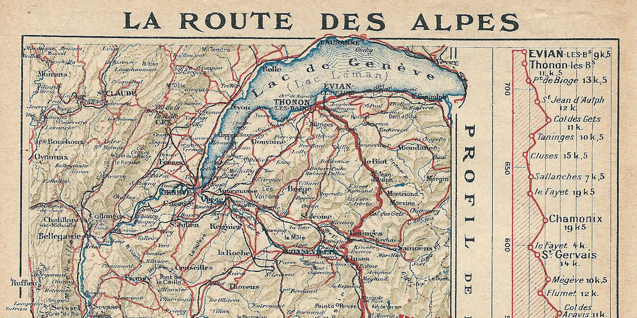
Chiusi in casa per via della pandemia da virus SARS-CoV-2, non ci rimane che fantasticare sui giri in moto che faremo appena saremo liberi di girovagare in libertà.
La Route des Grandes Alpes è grande classico da percorrere in direzione Nord-Sud, partendo dalle sponde del Lago Lemano a Thonon-les-Bain per raggiungere il Mar Mediterraneo a Menton.
L’itinerario originale è lungo 684 km e percorre solamente strade asfaltate, affronta 16 colli delle Alpi francesi (di cui 6 oltre i 2.000 m s.l.m.) e supera i 15.700 metri di dislivello totale.
Per raggiungere la partenza della Route, abbiamo ideato un anello che da Torino passa per la Val d’Aosta e attraversa il confine svizzero tramite il Colle del Gran San Bernardo (2.473 m s.l.m.); si entra in Francia con il Pas de Morgins (1.369 m s.l.m.) e raggiunge il Lago Lemano a Évian-les-Bains, località termale famosa per l’omonima acqua.
Raggiunta Thonon-les-Bain, inzia la vera Route des Grandes Alpes e la sua lunga successione di passi:
- Col des Gets (1.170 m s.l.m.)
- Col de la Colombière (1.613 m s.l.m.)
- Colle des Aravis (1.487 m s.l.m.)
- Les Saisies (1.650 m s.l.m.)
- Cormet de Roselend (1.967 m s.l.m.)
- Col de l’Iseran (2.770 m s.l.m.)
- Col du Télégraphe (1.566 m s.l.m.)
- Col du Galibier (2.645 m s.l.m.)
- Colle del Lautaret (2.058 m s.l.m.)
- Colle dell’Izoard (2.360 m s.l.m.)
- Colle di Vars (2.108 m s.l.m.)
- Colle della Cayolle (2.326 m s.l.m.)
- Col des Champs (2.087 m s.l.m.)
- Col de la Couillole (1.678 m s.l.m.)
- Col Saint-Martin (1.500 m s.l.m.)
- Col di Turini (1.604 m s.l.m.)
- Col de Castillon (706 m s.l.m.)
Si rientra a Torino passando per il Colle di Tenda (1.871 m s.l.m.).
È disponibile per l’acquisto una mappa dettagliata in scala 1:220.000 (1 cm = 2,2 km) dell’Istituto Geografico Nazionale francese .
Da qui puoi scaricare gratuitamente :
- “Roadbook” bianco & nero
- “Roadbook” a colori
- “Roadbook” stampabile in formato A4
- Traccia GPX - Route des Grandes Alpes
- Traccia GPX - Route des Grandes Alpes - Anello da Torino
Per navigatori TomTom collega il dispositivo via USB e copia il file GPX cartella GPX2ITN/ .
Per navigatori Garmin collega il dispositivo via USB e nella cartella GARMIN/GPX/ , se non appare vai su Strumenti -> Dati Personali -> Importa .
Ultimo aggiornamento: 10 aprile 2020
- < 1000 km
- Rhône-Alpes
- Valle d'Aosta

In sella alla mia BMW R 1200 GS attraverso il traffico torinese, mi godo i tornanti delle alpi nord-occidentali e vado alla scoperta del mondo accompagnato da mia moglie Stefania .
- Destinazioni
- Diari di viaggio
- Schede e confronti
- Privacy Policy
- Cookies Policy
- Cambia Impostazioni Privacy Policy
Home Destinazioni
Route des Grandes Alpes, le Alpi Francesi in moto
Imperdibile, irrinunciabile, lunga e impegnativa: la Route des Grandes Alpes non è una strada, ma LA strada quando si parla di Alpi Francesi. Un viaggio in moto che si prolunga per 700 chilometri , dalle sponde francesi del Lago di Ginevra fino a Mentone, poco lontano dal confine italiano di Ventimiglia . La si percorre generalmente proprio in questa direzione, dal Lemano fino al Mediterraneo, ma nulla vi vieta di fantasticare, fare deviazioni e concedervi qualche sosta più lunga. Anche perché, con la sua lunghezza, non è certamente una gita da fare in giornata : contate almeno 3-4 giorni, ma se avete più tempo anche una settimana farà al caso vostro. A una signora strada come lei, bisogna dedicarsi con attenzione e rispetto.
Indice dei contenuti
Route des Grandes Alpes in moto. L’itinerario
Il percorso della Route des Grandes Alpes tocca complessivamente 16 valichi, colli e passi della Francia . Si inizia da Thonon-les-Bains e si arriva a Mentone. Da nord a sud, è questa la successione delle strade che incontrerete:
Col de Gets (1170 m)
Col de la colombière (1613 m), col des aravis (1486 m), col des saisies (1650 m), cormet de roselend (1968 m).
- Col de l’Iseran (2770 m) – Il punto più alto della Route des Grandes Alpes
Col du Télégraphe (1566 m)
Col du galibier (2645 m), colle dell’izoard (2360 m), colle di vars (2108 m), colle della cayolle (2326 m), col de la couillole (1678 m), col saint-martin (1500 m), col de turini (1604 m), col de castillon (706 m).
Complessivamente, questo grande itinerario scende sotto i 1000 m s.l.m. solo al Col de Castillon (vicino Mentone), e arriva quasi a quota 2800 metri con il mitico Iseran, il “Tetto d’Europa”. Si tratta di un itinerario con 16.000 metri di dislivello complessivo e che può essere percorso unicamente nei mesi estivi , ovvero tra maggio/giugno e ottobre. Nel resto dell’anno, a eccezione del Col du Télégraphe – che è sempre aperto – quasi tutti i passi rimangono chiusi in inverno.
Tutti i passi della Route des Grandes Alpes
Uno dei collegamenti più importanti tra Dranse e Giffre, la salita del Col de Gets impiega circa 12 chilometri per essere completata, con una pendenza di non poco conto, fino quasi al 10%. Le montagne più alte che si trovano nei dintorni del passo arrivano ben oltre quota 2000 metri.
Anche se è accessibile solo durante i mesi estivi, il Col de la Colombière è uno dei più amati nella zona del Massiccio di Bornes. 16 chilometri di percorso, pendenza all’11%, bellissime curve, dal 1960 in poi è stato una delle tappe della Route des Grandes Alpes più frequentata dal Tour de France. E guardando le sue curve, si capisce perché.
Attraversato 38 volte dal Tour de France, il Col des Aravis è il punto di passaggio più basso di questo tratto montuoso della Savoia, trovandosi ad un’altitudine di 1.486 metri . In questi luoghi l’ideale è preventivare un po’ di tempo, fermarsi spesso, respirare a pieni polmoni l’aria montana e godersi la vista dei monti, ma poi montare in sella e prendere il volo. Se volete fare una deviazione, a poche decine di chilometri c’è Annecy , la Venezia delle Alpi con i suoi canali e i romantici affacci sul lago.
Ai piedi della stazione sciistica omonima, il Col des Saisies è una strada particolarmente importante per chi ama lo sci e raggiungere le piste nei mesi invernali. Qui, del resto, si tennero anche alcune gare delle Olimpiadi invernali 1992 di Albertville.
Nel cuore della Savoia, un valico asfaltato davvero molto bello e vicinissimo alla nostra Valle d’Aosta. Durante il tragitto verso sud della Route des Grandes Alpes, il Cormet de Roselend è a metà della strada tra Valle d’Isere e Doron de Beaufort. Un percorso stretto, appassionante per gli sport invernali ma anche per chi ama tutti i tipi delle due ruote. Del resto, il Tour de France ci è passato ben 11 volte. Da visitare il Lago di Roselend, con le sue acque limpide.
Col de l’Iseran (2770 m)
È una delle esperienze su due ruote più bella d’Europa, quella che arriva ai 2770 m del Colle dell’Iseran . Comunemente viene definito il valico asfaltato più alto d’Europa . La Bonette, infatti, arriva sopra i 2800 metri ma con una strada ad anello, che non viene considerata dunque un passo vero e proprio. Il percorso classico tocca Bonneval sur Arc, Lanslevillard e Bourg-Saint-Maurice.
Con i suoi 1.556 metri, nel pieno del Massiccio des Cerces , è stato più volte una delle tappe di livello del Tour de France, situato a poca distanza dal Colle del Galibier. Il Col du Télégraphe è l’unico sulla Route des Grandes Alpes che non chiude mai, neanche durante l’inverno: questo grazie alla sua altitudine più ridotta, ma anche alla pulizia costante della strada. Una strada non in primissimo piano, ma che merita la tappa.
Sapete quando in una famiglia ci sono due fratelli quasi identici, ma diversi solo in altezza? È un po’ quello che succede tra Télégraphe e Col du Galibier , il secondo passo più alto della Route des Grandes Alpes dopo l’Iseran. Una strada impegnativa, che permette di arrivare alle piste da sci di Valloire e ammirare le Alpi Cozie da un’altezza decisamente rilevante, sopra quota 2600. Qui la neve vi accompagnerà 12 mesi su 12: un posto rinfrescante, specie viste le ultime estati.
Un itinerario in moto sul Colle dell’Izoard , nella regione francese della Provenza-Alpi-Costa Azzurra è capace di regalare emozioni uniche e indimenticabili. Questa strada, una di quelle fondamentali sulla Route , arriva poco sotto i 2400 metri di altitudine e permette di arrivare allo storico Rifugio Napoleone , costruito oltre due secoli fa. L’Izoard è anche la “strada di Coppi”: a lui e a Louison Bobet è dedicato il Memoriale , un obelisco in pietra realizzato nel 1934 per celebrare i due grandi campioni del ciclismo.
Facilmente raggiungibile anche dal Piemonte (ma visto che stiamo facendo la Route des Grandes Alpes, è quasi a fine percorso), collega Alpi e Provenza ed è uno dei punti d’accesso verso la bella zona di Briançon. Il Colle di Vars è spesso teatro delle competizioni ciclistiche, sia della Grande Boucle che del Giro d’Italia, che spesso vi sconfina per qualche chilometro. 2111 metri d’altitudine, paesaggi verdissimi e due parchi da visitare: quello del Queyras e dell’Ecrins.
Panorama mozzafiato e ottimo asfalto sono gli ingredienti del Col de la Cayolle , un passo circondato da paesini tipici nei quali fermarsi magari a mangiare qualcosa o a riposarsi, potendo contare su uno spettacolo della natura davvero unico. Alpi Marittime, quota decisamente interessante (2326 m s.l.m.), unisce la Valle dell’Ubaye (dipartimento delle Alpi dell’Alta Provenza) e la valle del Varo. E per un giro nei dintorni, il Lac de la Cayolle è meta naturale giusta.
Quasi 1700 metri per il Col de la Couillole, passo delle Alpi Marittime molto vicino al confine italiano. Non male la zona, che è aperta al traffico per sei-sette mesi all’anno: le gole di Cians, la valle del fiume Tinée. Nel 2017, la Parigi-Nizza ha visto una tappa qui alla presenza del campione spagnolo Alberto Contador.
Presente sia in varie edizioni del Tour de France che nella Parigi – Nizza, il Col Saint-Martin scollina a una quota precisa: 1500 m s.l.m. Attraversato dalla strada D-2205, è una delle salite più facili della Route des Grandes Alpes, con un buon asfalto. Per essere una tappa minore, non è male.
Anche se il nome farebbe quasi pensare a Torino, e dunque all’Italia, il Col de Turini si trova in Francia , tra le Alpi Marittime di confine, ed è una meta particolarmente amata dagli sportivi, motociclisti in testa (ma non solo). Qui si tengono rally, salite impegnative, eventi sportivi particolarmente partecipati: insomma, c’è decisamente da divertirsi. Alto “appena” 1600 metri, si può percorrere sia dentro la Route des Grandes Alpes che come fine settimana impegnativo tra Italia e Francia.
Pendenza fino al 7% ma percorso piuttosto semplice, quello del Col de Castillon , la prima (o ultima, dipende da dove si viene) salita appena usciti da Menton. Siamo poco sopra i 700 metri di quota in un contesto molto piacevole, un must per chi si trova nella zona della Costa Azzurra e anche poco frequentato. L’ideale per scoprire qualcosa di nuovo.
TrueRiders è il portale di riferimento dei motociclisti: percorsi, informazioni e notizie, eventi e motoraduni, diari di viaggio ed esperienze
Un capolavoro dell’arte e del turismo: alle porte della Capitale c’è una campagna che è una meraviglia
Paesaggi sconfinati che hanno ispirato i racconti di Goethe, i quadri di Nadorp e ...
Tra strade leggendarie e monasteri misteriosi questa strada in Romania non smetterà mai di stupirti
Le strade di montagna della Romania sono uno spettacolo per noi riders, e chi ha ...
Queste 5 moto costano meno di 8000 euro, e sono il perfetto mix di prestazioni e stile per il motociclista “risparmioso”
Stiamo per entrare nel vivo della stagione estiva, e sapete cosa significa? ...
© 2024 Valica Spa. P.IVA 13701211008 | Tutti i diritti sono riservati. Per la pubblicità su questo sito Fytur
Bison futé : un dimanche en rouge et noir sur les routes… à quoi s’attendre ?
La circulation sera particulièrement chargée ce dimanche sur l’ensemble du pays alors que nombre d’automobilistes vont prendre la route du retour à l’issue de ce long week-end de pont.

Même sans Jeanne Mas en fond sonore, vous risquez de passer votre dimanche « en rouge et noir » si vous prenez la route. Bison futé voit en effet rouge sur l’ensemble du pays ce dimanche 12 mai dans le sens des retours à l’issue de ce long week-end de pont. Cinq régions sont même classées noires pour la journée : la Bretagne, les Pays de la Loire, le Centre-Val de Loire, la Normandie et les Hauts-de-France.
La circulation sera « très difficile » a averti dès le début de semaine Bison futé. De manière générale, les retours vers les grandes agglomérations généreront des bouchons et des ralentissements sur tous les grands axes du pays . Les difficultés les plus importantes sont attendues sur la façade atlantique, en région normande, en Auvergne-Rhône-Alpes et sur les axes desservant la côte méditerranéenne.
Une quinzaine d’axes routiers surchargés
Les bouchons devraient être présents dès le milieu de la matinée et perdureront jusque très tard dans la soirée. En Île-de-France, dès la fin de matinée, la circulation sera dense sur les autoroutes A10, A6 et A13. Ces difficultés de circulation seront enregistrées tout le long de l’après-midi et jusque tard dans la soirée essentiellement sur l’A10. La réouverture de l’A13 dans le sens Normandie-Paris ce vendredi devrait tout de même aider à fluidifier une partie du trafic.
Pour éviter au maximum les perturbations, Bison futé vous conseille de rejoindre ou de traverser la région francilienne avant 12 heures. Enfin, il est également recommandé de ne pas emprunter les axes suivants aux heures indiquées, où la circulation sera saturée :
- L’A25 entre Socx et Lille de 16 heures à 18 heures
- L’A13 entre Caen et Paris de 11 heures à 16 heures
- L’A11 entre Angers et Le Mans de 16 heures à 20 heures
- La N157 et l’A81 entre Rennes et Le Mans de 14 heures à 19 heures
- La N165 entre Quimper et Nantes de 16 heures à 18 heures
- L’A10 entre Niort et Poitiers de 13 heures à 16 heures
- L’A7 entre Salon-de-Provence et Orange de 11 heures à 13 heures, et entre Orange et Lyon de 12 heures à 21 heures
- L’A9 entre l’Espagne et Narbonne de 13 heures à 18 heures, et entre Montpellier et Orange de 15 heures à 17 heures
- L’A61 entre Narbonne et Toulouse de 15 heures à 19 heures
- Le tunnel du Mont-Blanc (N205) dans le sens Italie-France de 11 heures à 23 heures
Le trafic sera également particulièrement dense plusieurs axes, il faut vous attendre à des difficultés ponctuelles si vous circulez aux horaires mentionnés :
- L’A7 entre Marseille et Salon-de-Provence de 11 heures à 17 heures
- L’A84 entre Rennes et Caen de 12 heures à 18 heures
- L’A83 entre Niort et Nantes de 16 heures à 19 heures
- L’A10 à hauteur de Bordeaux de 15 heures à 19 heures, entre Poitiers et Tours de 15 heures à 21 heures, et entre Tours et Orléans de 12 heures à 23 heures
- L’A63 entre Bayonne et Bordeaux de 10 heures à 19 heures
- L’A9 entre Narbonne et Montpellier de 11 heures à 21 heures
- L’A20 entre Limoges et Châteauroux de 13 heures à 19 heures
- L’A75 entre Béziers et Millau de 11 heures à 14 heures
- L’A89 entre Brive-la-Gaillarde et Clermont-Ferrand de 15 heures à 17 heures
Si en revanche vous avez prévu de prendre la route seulement ce lundi dans le sens des retours, pas d’inquiétude à avoir, la journée est classée verte par Bison futé.
Pour soutenir votre journalisme local, abonnez-vous !
Pourquoi voyez-vous ce message ?
Vous avez choisi de refuser le dépôt de cookies, vous pouvez à tout moment modifier votre choix, ici .
Le contenu de ce site est le fruit du travail de journalistes qui vous apportent chaque jour une information locale de qualité, fiable, complète, et des services en ligne innovants. Ce travail s’appuie sur les revenus complémentaires de la publicité et de l’abonnement.
Déjà abonné ?
Connectez-vous ou créez un compte
Pour pouvoir enregistrer un article, un compte est nécessaire.
- Annecy / Rumilly / Les Aravis
- Annonay / Nord Ardèche
- Aubenas / Privas / Vallée du Rhône
- Bourgoin-Jallieu / Nord-Dauphiné
- Chambéry / Aix-les-Bains
- Edition Provençale
- Grand Genève / Chablais / Ain
- Grenoble / Agglomération
- Grésivaudan / Oisans
- Hautes-Alpes / Alpes de Haute-Provence
- La Tour-du-Pin / Nord-Dauphiné
- Mont-Blanc / Arve
- Montélimar / Drôme Provençale
- Romans / Nord Drôme
- Tarentaise / Maurienne
- Valence / Rhône Crussol / Vallée de la Drôme
- Vienne / Roussillon
- Voiron / Saint-Marcellin
- Newsletters
- Libra Memoria

Grenoble et son agglomération
sam. 11/05/2024
- Activer JavaScript dans votre navigateur pour accéder à l'inscription sur notre site
Si vous voyez ce champ, ne le remplissez pas
Le Dauphiné Libéré, en tant que responsable de traitement, recueille dans ce formulaire des informations qui sont enregistrées dans un fichier informatisé par son Service Relations Clients, la finalité étant d’assurer la création et la gestion de votre compte, ainsi que des abonnements et autres services souscrits. Si vous y avez consenti, ces données peuvent également être utilisées pour l’envoi de newsletters et/ou d’offres promotionnelles par Le Dauphiné Libéré, les sociétés qui lui sont affiliées et/ou ses partenaires commerciaux. Vous pouvez exercer en permanence vos droits d’accès, rectification, effacement, limitation, opposition, retirer votre consentement et/ou pour toute question relative au traitement de vos données à caractère personnel en contactant [email protected] ou consulter les liens suivants : Protection des données , CGU du site et Contact . Le Délégué à la Protection des Données personnelles ( [email protected] ) est en copie de toute demande relative à vos informations personnelles.
- Dans un article
- Dans ma ville
- Retour du week-end de l'Ascension : un dimanche rouge et noir sur les routes
- Les grandes énigmes
Trafic Retour du week-end de l'Ascension : un dimanche rouge et noir sur les routes
Sans surprise, ce dimanche 12 mai s'annonce chargé sur les routes. Bison futé voit rouge dans le sens des retours et noir dans l'ouest et le nord du pays.

De manière générale, les retours vers les grandes agglomérations généreront des bouchons et des ralentissements sur tous les grands axes du pays. Photo d'illustration Sipa/Romain Doucelin
Les automobilistes devront s'armer de patience ce dimanche. En cette fin de week-end de l'Ascension, Bison futé voit rouge à l'échelle nationale dans le sens des retours et noir dans l'ouest et le nord du pays.
De manière générale, les retours vers les grandes agglomérations généreront des bouchons et des ralentissements sur tous les grands axes du pays, prévient Bison futé .
Ce contenu est bloqué car vous n'avez pas accepté les cookies et autres traceurs.
En cliquant sur « J’accepte » , les cookies et autres traceurs seront déposés et vous pourrez visualiser les contenus ( plus d'informations ).
En cliquant sur « J’accepte tous les cookies » , vous autorisez des dépôts de cookies et autres traceurs pour le stockage de vos données sur nos sites et applications à des fins de personnalisation et de ciblage publicitaire.
Vous gardez la possibilité de retirer votre consentement à tout moment en consultant notre politique de protection des données . Gérer mes choix
Des difficultés importantes en Auvergne-Rhône-Alpes
Les difficultés les plus importantes sont attendues sur la façade atlantique (N165), en région normande (A84 et A13), en Auvergne-Rhône-Alpes (A7, N205) et sur les axes desservant la côte méditerranéenne (A9, A61). Elles seront présentes dès le milieu de la matinée ce dimanche et perdureront jusque très tard dans la soirée.
Les conseils de Bison futé pour ce dimanche dans le sens des retours
- rejoignez ou traversez l’Île-de-France avant 12h, - évitez l’autoroute A25, entre Socx et Lille, de 16h à 18h, - évitez l’autoroute A13, entre Caen et Paris, de 11h à 16h, - évitez l’autoroute A11, entre Angers et Le Mans de 16h à 20h, - évitez la route nationale N157 et l’autoroute A81, entre Rennes et Le Mans de 14h à 19h, - évitez la route nationale N165, entre Quimper et Nantes, de 16h à 18h, - évitez l’autoroute A10, entre Niort et Poitiers, de 13h à 16h, - évitez l’autoroute A7 entre Salon-de-Provence et Orange de 11h à 13h et entre Orange et Lyon, de 12h à 21h, - évitez l’autoroute A9 entre l’Espagne et Narbonne de 13h à 18h et entre Montpellier et Orange, de 15h à 17h, - évitez l’autoroute A61 entre Narbonne et Toulouse, de 15h à 19h, - évitez le tunnel du Mont-Blanc (N205), entre l’Italie et la France, de 11h à 23h.
En Île-de-France, dès la fin de matinée, la circulation sera dense sur les autoroutes A10, A6 et A13. Ces difficultés de circulation seront enregistrées tout le long de l’après-midi et jusque tard dans la soirée (essentiellement sur l’A10).
- France - Monde
- Ligue des Champions
- Europa League
- Europa Conference League
- Premier League
- JO Paris 2024
- Sports de combat
- Coupe de France
- Trophées des Champions
- Barrages Ligue 1 - Ligue 2
- Barrages Ligue 2 - National
- Championship
- Community Shield
- Carabao Cup
- Supercoupe d'Espagne
- Copa del Rey
- Supercoupe d'Italie
- Coupe d'Italie
- Supercoupe d'Allemagne
- Coupe d'Allemagne
- Liga Portugal
- Supercoupe Portugal
- Coupe du Portugal
- Coupe de la Ligue du Portugal
- Ligue des Champions (F)
- Coupe du Monde (F)
- Coupe du Monde 2022
- Supercoupe d'Europe
- Équipe de France
- Qualifs Coupe du Monde
- Qualifs Euro
- Ligue des Nations
- Copa America
- Matchs amicaux internationaux
- Youth League
- Mondial des Clubs
- Championnat des Pays-Bas
- Scottish Premiership
- Super Lig Turquie
- Jupiler Pro League
- Super League Suisse
- Copa Libertadores
- Copa Sudamericana
- Chinese Super League
- Coupe du monde (H/F)
- Gallagher Premiership
- Champions Cup
- Challenge Cup
- VI Nations (H)
- VI Nations (F)
- Tests matchs
- XV de France
- Super Rugby
- Betclic Elite
- FIBA Ligue des champions
- FIBA Eurocoupe
- Championnats du monde (H/F)
- Championnats d'Europe (H/F)
- Open d'Australie
- Roland Garros
- Coupe Davis
- Rolex Paris Masters
- Masters Indian Wells
- Masters Miami
- Masters Monte-Carlo
- Masters Madrid
- Masters Rome
- Masters Montréal
- Masters Cincinnati
- Masters Shanghai
- Tennis de table
- Tour de France
- Championnats du Monde
- UCI World Tour
- Championnats d'Europe
- Liqui Moly StarLigue
- D1 Féminine
- Championnats de France
- Ligue de diamant
- CEV Ligue des Champions
- Ligue des nations
- Jeux Olympiques
- Sports Extrêmes
- Super Moscato Show
- Rothen s'enflamme
- Intégrale Foot
- RMC Football Show
- RMC Sport Show
- Intégrale Sport
- Les Grandes Gueules du Sport
- Les courses RMC
- Les Paris RMC
- RMC Poker Show
- Double contact
- Story RMC Sport
- Les Courses RMC
- Comparateur
- Chaîne RMC Sport
- Newsletters
- Sport et société
- Devenez annonceur
Alpes-de-Haute-Provence: les restrictions de circulation pour le passage de la flamme olympique

Différentes réglementations ont été appliquées aux sept communes impliquées dans ce moment historique. - AFP

Le samedi 11 mai, les Alpes-de-Haute-Provence accueilleront à leur tour la flamme olympique. Pour l'occasion, un vaste dispositif a été mis en place dans les communes concernées pour le relais.
Dans le département, les voies de circulation seront globalement fermées aux véhicules légers au minimum 1h30 avant l'arrivée du convoi de la flamme olympique. Les poids lourds seront quant à eux bloqués 4h avant le convoi. Différentes réglementations ont été appliquées aux sept communes.
Moustiers-Sainte-Marie
Dans la commune de Moustiers, la flamme passera entre 9h et 9h20. Aucune circulation ni stationnement de véhicules ne sera autorisé dans le centre entre 8h et 10h. Pour le stationnement des véhicules avant 8h, plusieurs parkings sont proposés gratuitement: le parking Maïre et celui du stade de sport. De ces deux points, il faudra 15 min à pied pour se rendre au centre du village.
A Sisteron , l’accès au centre-ville sera réglementé à partir de 8h. Pour les véhicules venant du Nord de la Ville, une déviation est mise en place par le chemin de la Marquise. Elle sera néanmoins interdite aux véhicules de plus de 3,5 tonnes.
En venant du Nord, l'autoroute A51 par l'entrée Nord et jusqu'à la sortie Sud, dont les axes principaux vers le centre-ville, demeureront ouverts jusqu'à la mairie via la RD 4085, l’avenue Jean-Jaurès et celle de La Libération ou par les Plantiers puis l’avenue Alsace Loraine et celles des Arcades. L'accès sud est à privilégier pour se rendre au centre-ville après 8 heures du matin.
A noter que le CD 4 restera ouvert dans les deux sens de circulation entre le pont de la Baume et le giratoire de l’A51 jusqu’à 15 minutes avant le départ de la Flamme prévu à 9 h 30.
Pour se garer, les parkings suivants resteront ouverts : parking place de l’hôtel de ville, parking de l’Alcazar, parking de la Gare, parking Toyota (près de la Gare), parking de l’église (place Général De Gaulle), parking Melchior-Donnet et le parking du plan d’eau Nord
Digne-les-Bains
A Digne, la circulation sera interdite de 10h45 à 14h pendant le passage du cortège olympique du croisement du centre équestre, situé Route de Barles, jusqu’au Plan d’eau des Ferréol. La circulation sera aussi interdite du rond-point Vietto sur l’avenue Maréchal Juin jusqu’à l’intersection avenue François Cuzin. Cependant, des itinéraires de déviation seront mis en place pour contourner les axes fermés : au niveau du stationnement, à plusieurs endroits dès le vendredi 10 mai, à partir de 8h, et jusqu’au samedi 11 mai 14h. Malgré le passage de la flamme le marché hebdomadaire est maintenu sur la place Général De Gaulle.
La circulation sera interdite de 17h15 à 22h sur tout le parcours du cortège olympique : Avenue R. Ryckebusch, Avenue du Moulin Neuf, Rond-point de l’Olivette, Boulevard Charles de Gaulle, Avenue Jean Giono, Boulevard de la Plaine, Promenade Aubert Millot, Boulevard Mirabeau, Rue Lemoyne, Boulevard des Tilleuls, intersection rue de la Tannerie/Boulevard des Tilleuls, Boulevard Louis Martin Bret, Boulevard Georges Clémenceau, rue du Grand Chêne, Avenue de l’Argile, Montée de la Mort d’Imbert.
Dès 14h, et toutes les 30 minutes, des navettes gratuites circuleront dans la ville pour emmener les Manosquins jusqu’au site de célébration au Parc de la Rochette.
Forcalquier
Dès 16h30, le premier des treize porteurs s’élancera de la piscine municipale, avenue Claude-Delorme. Après deux tours en ville, le dernier relayeur arrivera à 17h10 place Martial-Sicard . Le centre-ville sera donc inaccessible dès 15h pour les automobilistes.
Barcelonnette
La circulation dans les rues du centre-ville sera interrompue à partir de 16h30. La flamme partira à 18h du stade Municipal Léon Signoret et arrivera à la mairie aux alentours de 18h35.
- "Je suis sur un nuage": ces relayeurs de la flamme à Marseille racontent leur joie
- Relais de la flamme: le chaudron sera allumé par la nageuse Ophélie-Cyrielle Étienne à Manosque
- JO de Paris 2024: rôle des gardiens, choix des porteurs, surprises au programme... Les coulisses du relais de la flamme olympique
Colmars-les-Alpes
La flamme passera de 13h35 à 13h55 dans les rues du centre-ville. Dans la traversée de la ville la circulation sur la route départementale 908 sera interdite de 13h à 14h.
Top Articles

PSG: "Une légende du club", les mots forts Luis Enrique pour Mbappé après sa grande annonce
Mercato: très ému, kylian mbappé annonce officiellement son départ du psg, "le plus grand club de france", real madrid-bayern: la trousse de toilette qui alimente la polémique arbitrale autour de szymon marciniak, psg: l'absence très remarquée de nasser al-khelaïfi dans la liste des remerciements de mbappé, un joueur français de l’olympiacos se paye emiliano martinez avec un photo-montage de son geste obscène.
Mort du rappeur Nikus Pocus, membre du groupe Svinkels
IMAGES
VIDEO
COMMENTS
The Route des Grandes Alpes is one of Europe's iconic cycling routes, taking you through the French Alps, from Geneva to Nice. This 720 kilometre traverse of the Alps winds along mountain sides, glaciers, mountain pastures and forests, taking in around 17,100m of climbing and 18 major cols; mythical beasts such as the Col de l'Iseran, Col du Galibier, Col du Lautaret, Col d'Izoard.
The world-famed Col du Galibier mountain pass forms the first stage of the Route des Grandes Alpes.One of the highest mountain passes in the Alpes French South, it is also a classic on the Tour de France.Revel in the exceptional natural scenery of Écrins National Park before heading to Briançon Fort and the Jardin Botanique Alpin du Lautaret, where you will learn all there is to know about ...
Facts about this scenic road trip in the Alps: Crossing the French Alps from north to south for more than 700 km (435 miles), the Route des Grandes-Alpes is a prestigious route that will make you discover majestic panoramas by taking you through 17 passes among the highest in the French Alps. This route has over 17,000 meters of vertical drop ...
Toutes les deux traversent les Alpes françaises du nord au sud ou du sud au nord, de Thonon-les-Bains (74) à Nice (06). Sur Route des Grandes Alpes®, vous suivez les traces des coureurs du Tour de France et partez à l'assaut des plus hauts cols routiers (Iseran, Galibier, Izoard, Madeleine, etc.).
La Route des Grandes Alpes is a 447 mile / 720km tourist itinerary through the Alpes-Maritimes department in the Provence-Alpes-Côte d'Azur region in eastern France, between Lake Genèva (also known as Lac Léman) and the French Riviera. Construction of the route started in 1909 and the road was opened in 1913, and fully paved in 1937 before ...
The Route des Grandes Alpes® links Lake Geneva to the Mediterranean, crossing the French Alps from north to south, or from south to north, offering a cycling adventure that's accessible to all, either on a traditional bike or on an electric bike (or e-bike). Following in the tracks of the Tour de France, take on the finest mountain road ...
Route des Grandes Alpes à Vélo. Description All stages Reviews and personal stories. 720 Km. Difficult. Thonon-les-Bains. Nice. Route des Grandes Alpes® links Lake Geneva and Thonon-les-Bains (Haute-Savoie) with the Mediterranean and Nice (Alpes Maritimes). Route des Grandes Alpes® is so named because it crosses the highest road passes ...
857 Km. Route des Grandes Alpes Gravel. Thonon-les-Bains. Nice. Les 26 étapes et variantes de l'itinéraire de la Route des Grandes Alpes : cartes, dénivelés et grands cols traversés du Léman à la Méditerranée.
The Route des Grandes Alpes® links Lake Geneva to the Mediterranean, crossing the French Alps north-south or south-north, offering a great adventure by bike or e-bike. Following in the tracks of the professional cyclists on the Tour de France, head off to tackle the finest road passes, to plunge into the heart of grandiose landscapes and to ...
Route des Grandes Alpes® relie le lac Léman à la mer Méditerranée en traversant les Alpes françaises du nord au sud, pour une aventure en vélo ou VAE (vélo à assistance électrique). Sur les traces des coureurs du Tour de France, partez à l'assaut des plus beaux cols routiers , plongez au cœur de paysages grandioses et vivez un ...
Avec ses 720 kilomètres entre le lac Léman et la Méditerranée, la Route des Grandes Alpes® est un itinéraire de road-trip idéal pour s'enivrer des plus beaux paysages alpins depuis sa voiture. Depuis 1909, cette route touristique emprunte les voies secondaires et passe par 17 cols (!) de montagne parmi les plus pittoresques (et les plus hauts!) des Alpes françaises pour rejoindre les ...
The Route des Grandes Alpes is a tourist itinerary through the French Alps between Lake Geneva and the French Riviera passing over all the high passes of the Alps within France. [1] [2] The road starts at Thonon-les-Bains and climbs via Les Gets and Cluses. It then heads to Saint-Gervais and Megève, over the Col des Saisies (1,633 m (5,358 ft)).
My tour starts from the pretty spa town of Thonon-les-Bains on the banks of the Lake Geneva. If you get there the day before, then take a nice walk along the highest lake in Europe! DAY 1 - Map of the day's itinerary. Le 1st day route of the circuit on the route des grandes Alpes leaves from Thonon Les Bains and arrives at Beaufort. Here is the ...
The Route des Grandes Alpes stretches from the shores of beautiful Lake Geneva, the largest lake in Western Europe, to the bustling resort of Menton on the Côte d'Azur, crossing many of the highest, and most well-known alpine cols along the way. £1,700, 7 NIGHTS. 700KM, 17 COLS, AROUND 18,000 METRES OF CLIMBING
Is Route des Grandes Alpes open? Set high in the French Alps, this drive enjoys legendary status. It tops out at 2,802 m (9,193 ft) above sea level. The route is totally open between June (after the snow has melted) and October. Most of the passes are open at the end of May. But the highest ones - Iseran, Galibier, and Izoard - are clear ...
An amazing fully-supported cycling tour taking you from Lake Geneva to Menton on the Cote d'Azur, France. Over 17,800m of climbing! Find out more today. ... The last day of Route Des Grandes Alpes starts with a short descent and a gentle climb up Col de la Couillole, following is Col de Saint Martin, Col de Turini and through the last climb up ...
Route des Grandes Alpes und Route Napoleon als grosse Rundtour in den Französischen Alpen. Als abwechslungsreiche Rundtour mit dem Motorrad in den Französischen Alpen bietet sich die Kombination der Route des Grandes Alpes mit der Route Napoleon an. Pässe.Info empfiehlt - nicht nur aus historischen Gründen - zuerst die Route des Grandes ...
Die 677 Kilometer lange Route des Grandes Alpes führt vom Genfer See an die Côte d'Azur. Hier reihen sich die berühmtesten Tour-de-France-Pässe aneinander. Mehr als 16.000 Höhenmeter, verteilt auf sieben Tage, verlangen vom Radler ein gewisses Maß an Leidensfähigkeit.
Infos: https://www.paesse.info Hotels: https://www.booking.com/index.html?aid=8059759 Update: 14.08.2023 Karte, Wegpunkte und Track der Tour Route des Grandes Alpes ...
230 km / 5h. Great start of our Route des Grandes Alpes motorcycle tour in the French Alps on the little roads of the Bauges Range.Go higher through legendary mountain passes to discover Northern French Alps' beauty.Enjoy the motorcycle ride through the Beaufortain and its gorgeous Cormet de Roselend…Admire the dramatic scenery up the mythical Col de l'Iseran, highest Pass in Europe with ...
Die Route des Grandes Alpes zählt 21 Pässe, die es bis ans Mittelmeer zu bezwingen gibt. Der Startpunkt ist in Thonon-les-Bains am Genfersee (FR: Lac Léman). Die Beschilderung der Strecke ist eigentlich ganz gut. Wir hatten uns im Vorfeld die gesamte Route auf unsere Navi-App hochgeladen.
La Route des Grandes Alpes è grande classico da percorrere in direzione Nord-Sud, partendo dalle sponde del Lago Lemano a Thonon-les-Bain per raggiungere il Mar Mediterraneo a Menton. L'itinerario originale è lungo 684 km e percorre solamente strade asfaltate, affronta 16 colli delle Alpi francesi (di cui 6 oltre i 2.000 m s.l.m.) e supera ...
Imperdibile, irrinunciabile, lunga e impegnativa: la Route des Grandes Alpes non è una strada, ma LAstrada quando si parla di Alpi Francesi. Un viaggio in moto che si prolunga per 700 chilometri, dalle sponde francesi del Lago di Ginevra fino a Mentone, poco lontano dal confine italiano di Ventimiglia. La si percorre generalmente proprio in ...
Même sans Jeanne Mas en fond sonore, vous risquez de passer votre dimanche « en rouge et noir » si vous prenez la route. Bison futé voit en effet rouge sur l'ensemble du pays ce dimanche 12 ...
Sans surprise, ce dimanche 12 mai s'annonce chargé sur les routes. Bison futé voit rouge dans le sens des retours et noir dans l'ouest et le nord du pays. A.SI. - Aujourd'hui à 18:33 - Temps de ...
L'effervescence monte dans les Alpes-de-Haute-Provence à l'occasion du passage de la flamme olympique le samedi 11 mai. Des mesures de sécurité et de restrictions de circulation ont été ...