- Trekking & Travel Events
- Travel Organizations
- Himalayan Treks
- Maharashtra Treks
- Karnataka Treks
- Travel Guides
- Weekend Getaways
- Trekking Tips & Advice

Dhodap fort beautiful trek – An ultimate guide
- Trekking Destinations
Table of Contents
Dhodap Fort Trek: An Introduction

Dhodap fort, another hidden gem from the Nashik range, is known for its grand views of the surrounding. It is the 2nd highest fort after Salher fort and 3rd highest peak after Kalsubai peak & Salher.
Dhodap fort should be on every explorer’s map because of the variety of things it offers. Caves at the top where one can camp, three temples of Lord Hanuman, Lord Ganesh & Lord Shiva, water tanks, ruins of settlements & the museum at the base village of Hatti.
One can do the trek throughout the year; however, the best season is winter.
- Height: 4760 feet
- Best Season: Winter
- Difficulty: Medium
- Region: Nashik
How to reach Dhodap fort
The trek starts from the village of Hatti, which is approximately 62 kms from Nashik. It can get tricky to reach here via public transport; hence it is preferable to travel in your vehicle.
Public Transport:
Coming from Mumbai or Pune, one can take a train or a bus to Nashik, and from Nashik, many buses run towards Vadalibhoi. Depending on your bus type, they may cost anywhere between INR 100 – INR 250.
From Vadalibhoi, you can hire a private jeep that can take you directly to Hatti village.
Alternatively, you can also take a train to Kasara and hire a local vehicle to take you to Hattigaon (it is an expensive option but can be convenient).
Private Vehicle:
From Mumbai , the distance to Hatti village is 227 km via NH160 and can take anywhere between 5-6 hours . It is advisable to start as early as possible to complete the trek in a day and camp overnight at Dhodap fort.
From Pune, the distance is 270 km, and it takes around 7-8 hours to reach.
Mumbai Midnight Cycling - Treks and Trails
- Post-Monsoon (Mid-Sep to Mid-Oct)
- Easy-Moderate
Igatpuri Lakeside Camping - Treks and Trails
- Winter (Dec, Jan, Feb)
Visapur Monsoon Trek - T Trikon
- Monsoon (Jul, Aug, Mid-Sep)
Trek Route & Difficulty

The trek to the top of the fort from the base village is around 6 km & can take anywhere between 2-2.5 hours to reach .
The trek is relatively simple, and anyone can do the trek. Beginners should hire a guide from the local village or trek with a group that organises such treks.
A trekker with good experience can do it on his own, even without the help of a guide.
If you plan to camp overnight, carry enough food and camping equipment. You can take the help of the locals to arrange firewood and warm blankets if you plan to trek here in the winters, as temperatures can fall to single digits after midnight.
After an hour’s hike from the base village, you reach the first main entrance of Sonar machi. The left-hand side takes you to the Shiva temple.
From Sonar machi, after a hike of 30 mins, you reach the steps and the railings patch. The entire trail till here is appropriately marked.
From this point until the top of the Dhodap plateau, the distance is around 2 kms and can take an hour to reach.
Ramblr Route Link
Frequently Asked Questions (FAQs)
Dhodap Fort trek in Maharashtra is considered to be of moderate difficulty. It involves a steep ascent to the top of the fort, which can be challenging for some individuals. However, the trail is well-defined and the views from the fort are breathtaking, making it a worthwhile experience. The trek usually takes around 3-4 hours to complete and is suitable for individuals with a moderate level of fitness.
Dhodap Fort is a historical fort located in the Nashik district of Maharashtra, India. It was built during the Maratha Empire in the 17th century. The fort has a unique triangular shape and stands atop a hill, providing commanding views of the surrounding area. The fort was strategically located on the trade route between the Maratha Empire and the Gujarat Sultanate, and was used to monitor and control trade and commerce.
During the reign of the Maratha leader Shivaji, the fort was one of the many forts he captured from the Mughal Empire. In the 19th century, the fort was occupied by the British East India Company and was later used as a prison and administrative center.
Video of the trek
Nanemachi waterfall | Harishchandragad | Karnala Fort | Peb Fort | Jivdhan Fort | Mahuli Fort | Irshalgad | Sondai Fort | Salher Fort | Aadrai Jungle Trek | Ganpati Gadad | Korigad Fort | Tandulwadi | Garbett Plateau | Sudhagad Fort | Kataldhar Waterfall | Plus Valley | Mangi Tungi | Malanggad | Gorakhgad | Bhairavgad | Kohoj Fort | Rajgad | Ratangad | Bhimashankar Trek | Visapur Fort | Kalsubai Trek | Tikona Fort | Rajmachi Fort | Sandhan Valley | Kalavantin Durg | Andharban Trek | Harihar Fort | Kalu Waterfall
Did you like this trek guide for the Dhodap fort trek?
We have 100s more such guides on similar off-beat experiences & we send out such guides, offers, hidden gems, and trekking destinations weekly via email. Subscribe to our newsletter to get them directly into your inbox.
- treks near mumbai
Prithviraj G Pardeshi
Any arrangements to stay in Hatti village. My age is 71 year. Can I climb on this fort. I visited this Hatti village in my childhood for marriage purpose.
Nomads of India
Hi Prithviraj,
We are not sure about the Hatti village. About doing this fort trek, we recommend to check your fitness level and go for the trek with a guide or a trekking group who can assist you about the Dhodap fort trek.
Rajgad Trek - How To Do It On Your Own - Nomads of India
[…] Related Article: Dhodap Fort Explore Dhodap Fort, the Second Largest Fort in Maharashtra, nestled in the scenic Nashik region – a… […]
Add a comment
Leave a reply · cancel reply.
Your email address will not be published. Required fields are marked *
This site uses Akismet to reduce spam. Learn how your comment data is processed .
- Share via...
Spread the word.
Share the link on social media.
Confirm Password *
By registering, you agree to the Terms of Service and Privacy Policy . *
Username or email *
Forgot Password
Lost your password? Please enter your email address. You will receive a link and will create a new password via email.
Sorry, you do not have permission to ask a question, You must login to ask a question.
Sorry, you do not have permission to add post.
Please briefly explain why you feel this question should be reported.
Please briefly explain why you feel this answer should be reported.
Please briefly explain why you feel this user should be reported.
BestIndianTreks.com

BestIndianTreks.com Latest Articles
Top 14 toughest and most difficult treks in maharashtra.

There are more than 400 small to massive forts in Maharashtra. These forts are one of the best places for trekking. In the Sahyadri range, you have many options for trekking such as Sinhagad, Torna fort, Raigad, Rajmachi, Harishchandragad etc. Monsoon season is the best time to go for the treks in Maharashtra. Although there are many options for trekking, some treks are really difficult and challenging. Following is the list of top 14 most difficult and toughest treks in Maharashtra.
List of Top 14 Hardest Treks in Maharashtra
- Lingana Fort Trek – Raigad district
Alang, Madan, Kulang Forts (AMK Trek) – Nashik 1372m (Alang)
- Salher Fort Trek – Nashik 1567m
- Harishchandragad Trek via Nalichi Vaat – Ahmednagar 1422m
- Dhak Bahiri Caves Trek – Pune
- Kalsubai Peak Trek – Ahmednagar/Nashik 1646m
- Tailbaila Trek – Pune
- Kalavantin Durg Trek – Raigad district
- Harihar Fort Trek – Nashik 1120m
- Dhodap Fort Trek – Nashik 1472m
Jivdhan Fort Trek – Pune 1145m
- Bhairavgad Trek – Ahmednagar 1523m
- Rajgad Trek – Pune 1400 m
- Vasota Jungle Trek – Satara
Lingana Fort trek- Raigad district
Lingana is a huge pinnacle 30 km away from Mahad, Raigad. You need to do technical climbing, rappelling and walking through dense forest. That makes Lingana fort trek one of the most difficult treks in Maharashtra. To start the Lingana trek, you need to descend for almost 2-3 hours to reach the base point. Then you can start the actual climb.
Chhatrapati Shivaji Maharaj had built the Lingana fort . There were steps cut in the rocks to go to the fort. But it’s destroyed now. That’s why Lingana fort is almost inaccessible. Only experienced trekkers pick Lingana fort trek and I will also suggest you, consider all these points before going on a trek to Lingana Fort.
Alang, Madan, Kulang are the three consecutive forts in Nashik District and they are 22 km away from Igatpuri, Maharashtra. The trek to these forts is popularly known as AMK trek. There are 2 different routes available to go to Alang fort. It will take 8-9 hours to climb the Alang fort.
There is potable water available on the fort throughout the year. Also, there are two caves on the forts which can accommodate almost 50 people. You need to bring your own food. I will recommend you to visit Alang fort only with experienced trekkers or with expert trek organizers.
Which is the toughest trek in Maharashtra?
AMK trek involves rock climbing and rappelling. Also, the dense forest around it makes AMK trek one of the hardest treks in Maharashtra.

Salher Fort Trek- Nashik 1567m
Salher fort is among the tallest forts in Maharashtra and the second highest peak after the Kalsubai peak. I will definitely recommend you to spend a night on a Salher fort. It will make you realize the energy and the force of a massive Sahyadri range. There are rock-cut steps and pathways to reach to the top of the fort.

Harishchandragad Trek via Nalichi Vaat- Ahmednagar 1422m
Harishchandragad trek is quite popular among the trekkers. There are many worth seeing places on the fort. You may have heard about the Kokankada. It’s a cliff facing towards the west side i.e. Kokan. That’s why the name. You will get a beautiful view of the surrounding from here.
There are 2-3 ways to reach this fort. Harishchandragad trek via Nalichi vaat is considered as the most difficult path. There are many Caves on Harishchandragad where you can spend a night. Many of the caves are still undiscovered, so all the best for your adventures expedition. I will recommend you to spend a night on the fort to enjoy the beautiful sunset and sunrise. Harishchandrgad is well connected with the major cities. Don’t forget to take your camera along with you because the pictures are gonna be awesome.

Dhak Bahiri Caves Trek- Pune
Dhak bahiri caves trek is one of the difficult treks near Pune . It is around 68km from Pune city. The name Dhak Bahiri is inspired by the God Bahiri. This is a challenging trek as you need to climb using the rope on a vertical rock. There is accommodation available in the caves for 15-20 people for the overnight camp.

Kalsubai Peak Trek- Ahmednagar/Nashik 1646m
Kalsubai is the highest peak in Maharashtra with the elevation of 1646m. There are two different routes to go on this trek. The peak is around 880 m high from the base. You can choose the popular route that starts from the base village of Bari. This route is well maintained and there are metal ladders at the cliffs and vertical slopes.
Kalsubai peak trek is one of the toughest treks in Maharashtra. It’s a one day trek and you will get amazing views of luscious green grass and multiple waterfalls.

Tailbaila Trek- Pune
Tail and Bail are the names of two wall-like structures at TailBaila. You can realize the difficulty of TailBaila trek by merely looking at it. Normal trekkers can go easily upto the halfway. They can rest there for a while. For the further trek, you need to climb the vertical rock. Only expert rock climbers can do this climb. TailBaila trek is almost 90 degree vertical climb which makes it one of the toughest treks in Maharashtra.
TailBaila is around 100 km away from Pune. It is one of the most challenging treks in Maharashtra so there is gonna be less crowd on TailBaila trek. You can ask local villagers for the food or bring your own. There are other worth-seeing places nearby such as Sudhagad, Ghangad and Thanale Buddhist Caves.

Kalavantin Durg Trek- Raigad district
Kalavantin Durg is built along with nearby fort Prabalgad for the Queen named Kalavantin. Although there is no fort on the Kalavantin Durg. It is used to keep an eye on the surrounding area. It’s a massive pinnacle and the rock-cut steps will take you all the way up to the summit. The view from Kalavantin Durg is amazing. Although it is one of the most difficult treks, it’s a popular trekking place in Maharashtra.
I will recommend you to go on weekdays to this trek. There is no more space on the summit so it’s always better to avoid the crowd. You can’t carry plastic bags or bottles on the trek. Local authorities have strict rules for the Kalavantin Durg trek. For the safety of the trekkers and to avoid accidents, they close Kalavantin Durg climb after 5 pm till 6 am.

Harihar Fort Trek- Nashik 1120m
Harihar Fort, also known as Harshagad is at the elevation of 1120 m. You need to use rock-cut steps for this trek. These steps are so narrow at some places that only one person can climb at a time. There are two different routes to go to the Harihar fort. The route starting from Harshewadi is easier than the Nirgudpada route. The path to the Harihar fort is as beautiful as the views from the top.
Harihar fort is around 40 km away from Nashik. You can complete this trek within a day. You will get amazing views of the Sahyadri mountain range from the top. Even if it’s one of the difficult treks, Harihar fort trek should be on your trekking list.

Dhodap Fort Trek- Nashik 1472m
Dhodap fort is the second tallest fort in Maharashtra after Salher fort. It is the third highest peak in Maharashtra after Kalsubai peak and Salher. Dhodap fort is around 75 km from Nashik. This fort is easily recognizable because of its unique structures.
You can start the trek from the base village Dhodambe. There are many caves on the fort. Carry an ample amount of water with you before the trek. You can accommodate yourself at the base village. Arrangement of food can be done by the locals.

Jivdhan fort/ Jeevdhan fort is in Junnar Taluka in Pune district. This fort also has rock-cut steps. There are many confusing jungle paths to reach to this fort. You need climbing gears and proper knowledge for the Jivdhan fort trek. That is why Jivdhan Fort trek is one of the most difficult treks in Maharashtra.
There are many unexplored storage places on the forts. You will also find cisterns and water tanks on the fort. There is a massive pinnacle beside the Jivdhan fort. You can see many forts such as Harishchandragad, Chavaand, Ratangad, Naneghat and Hadsar fort from top of the Jivdhan fort.

Bhairavgad Trek- Ahmednagar 1523 m
There are many forts in Maharashtra which have name Bhairavgad. Out of which Bhairavgad in Ahmednagar district is most challenging fort. Bhairavgad is surrounded by dense forest area and it is a part of Kalsubai-Harishchandragad Wildlife Sanctuary.
The route of Bhairavgad is one of the toughest which will examine your patience level and guts. There is a well-established climbing route available now. You must do this trek under the guidance of the experts. There are many water tanks and two caves present on the top of the fort. Carry ample amount of food and water with you for this trek.
Rajgad Trek- Pune 1400 m
Rajgad Fort is around 59 km away from Pune. It was the former capital of the Maratha Empire later it transferred to the Raigad. Rajgad is a huge fort and can not be explored in a day. You need to start the trek early at the morning. There are 3-4 routes available for the Rajgad trek.
Best time to visit the Rajgad is in monsoon season. You can stay overnight on the fort in Padmavati temple. There is enough space for a maximum of 50 people. Sinhagad and Torna fort are visible from the Rajgad fort.

Vasota Jungle Trek- Satara
Vasota fort is near Bamnoli village around 70 km from Satara. It is surrounded by the Shivsagar lake, which makes it one of the toughest treks in Maharashtra. You need to reach the starting point of the trek by boat. Then there is walking through the dense forest. Due to its natural defence system, Chhatrapati Shivaji Maharaj renamed the fort as Vyaghragad (Tiger’s fort).
Vasota Jungle trek is one of it’s kind experience and you must visit this trek for the amazing trekking memories.

Banner image (Harihar Fort) by Nayan Gavli

Vinay Kadam
Related posts.
- Sinhagad Fort (updated) - Things to know
- Top 10 Best Treks near Pune and Mumbai
You must login to add a comment.
[…] Read more: Top 14 Toughest and Most Difficult treks in Maharashtra […]
- Share on Facebook
- Share on Twitter
- Share on LinkedIn
- Share on WhatsApp
This is really helpful list of toughest treks in Maharashtra. I have been to few.
[…] There are also many forts in the region such as Salher Fort, Salota Fort, Dhamanya Fort, Hargad Fort and Mulher Fort at the western side. Salher fort trek is one of the toughest treks in Maharashtra. […]
[…] fort trek is one of the toughest treks in Maharashtra. It’s a straight forward well-marked trek. There is only one route for the trek so you will not […]
[…] Harishchandragad. So you can always explore the next difficult path. You have explored one of the toughest treks in Maharashtra and now its time to go to Kalsubai Peak, the highest peak in […]
[…] Harihar fort has very steep steps almost at 80-degree angle, which makes it one of the toughest treks in Maharashtra. […]

Kunagalu Betta Trek
Dhodap Fort Trek
The Dhodap Fort Trek is a treasure of a journey, supplying a remarkable experience for trekkers. Found in Maharashtra, it is the second-highest fort in the state and is loaded with shocks that make it stand out as one of the very best treks in the area. The trek is a reward for those who enjoy discovering its varied landscape and abundant background. The fort has been home to numerous leaders, consisting of the Nizams, Peshwas, Marathas, and British, and its curved entrance and distinct attributes will undoubtedly transfer you back in time. The trek provides impressive sights from an elevation of 4,750 feet, making it a must-do journey for those wishing to experience the fort’s magic.
Views You Will Get On Trail
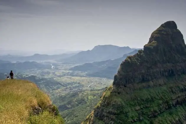
Flaunting a single shape, the landscape resembles a rock cut from its bordering surface. This unique form, called a dike, is an all-natural event developed when lava permeated into a pre-existing rock crack and ultimately strengthened. The outcome is a high, impressive development that stands apart from the bordering landscape, providing a one-of-a-kind and fascinating aesthetic experience.
From the raised placement of Dhodap Fort, one can absorb impressive views of the bordering landscape. As the 2nd highest possible fort in the location, the breathtaking sights use a one-of-a-kind viewpoint of the whole area. To the west, the Saptashrungi, Markandya Fort, Rawlya, and Jawlya Forts can be seen, while to the eastern, the twin forts of Kanchana-Manchana and Kanhergad show up. In addition, the Ikhara Pinnacle can be seen throughout the trek, supplying a striking aesthetic aspect to the trip.
The Dhodap Fort Trek is bountiful in archaeological sites, and prizes are hidden within the three-tiered plateau. Each degree offers a unique wonder:
- Spiritual structures
- Entrances decorated with Persian works
- A double-decker water storage tank
As you rise to greater degrees of the plateau, the fort reveals added marvels and overviews you via numerous areas of the Dhodap Fort.
Best Time to do Dhodap Trek
The best time to start the Dhodap Trek is between August and February. Throughout the rainy months of August and September, one can witness the dynamic flowers and rich green environments along the course. Pursuing the preliminary stage of the monsoon is suggested to delight in the sight of a flower-covered trail, although it might depend upon the timing of the monsoon that year. The trek is likewise pleasurable throughout the post-monsoon and winter. If camping along the trek, one can admire the clear night sky, best for stargazing, and opt for an early morning walk to witness the daybreak. The cold weather is an enjoyable environment, and the trek supplies sensational scenic views from the fort.
Dhodap Trek Trail Information
Start your early morning trek from Hatti Village, following a little mud trail northward along with the village. The distinct Dhodap Fort will emerge. Slowly ascending from the farmlands to the first plateau, Sonar Machi, in about half an hour. The preliminary phase of the trek travels through simple surfaces together with farmlands, then shifts to sporadic greenery as you approach the base of the hill. The last reach of Sonar Machi includes a 700-foot climb. As you enter the extensive Sonar Machi, the large magnitude of this raised plain will leave you in awe. The vast landscape extends before you, welcoming you to explore every nook and cranny. The plateau’s vastness will mesmerize your attention for a minimum of an hour and potentially even longer if you try to value each concealed treasure. The Sonar Machi’s history is abundant and waiting to be discovered, with both sides of the plateau using a wealth of surprises. Appreciate the stunning archways and many stone idols committed to Hanuman, Shiva, and Shankar temple. A fortress likewise surrounds the plateau, and you can check out either the eastern or western front to find natural lakes that exist most of the year. In addition, you’ll discover a couple of settlements of individuals who have survived on this plateau for generations, consisting of knowledgeable goldsmiths, which is how the table made its name. A noteworthy function of this Sonar Machi is the unique two-story stepwell. The well is accessed through a staircase, a typical sight in Rajasthan or Gujarat but uncommon for this area. Sadly, the water here is not ideal for drinking. If you’re preparing to camp overnight, it’s best to check out the plateau early in the morning when the sun is still low, splitting the exploration into two parts: the eastern side takes around 40 minutes, while the western side can be covered in half an hour. From Sonarmachi, the course is steeper as you continue towards the 2nd level plateau. The trail is significant and simple to follow. The climb will take around 500 feet and can be finished in about 20 minutes. Take a minute to check out the 2nd plateau, where you can see rock carvings of idols. There are likewise several lookout points where you can enjoy scenic views of the surrounding location. Before reaching the 2nd plateau, there is a little water source offered. After a few extra minutes of trekking, you will stumble upon railings with sculpted rock actions. Likewise, a giant ladder is in place to help with ascending a high location. Scale this area. The steps continue climbing, decorated with gorgeous arches. If you are traveling throughout the rainy season, the sight is a lot more stunning. You will witness a lively carpet of wildflowers, even more boosting the appeal of these fort arches. Step through an elaborate archway and take a better want to value the Farsi engravings engraved into the walls by the Peshwas throughout their 16th-century reign. These distinct markings make this fort stand out from others. As you dive much more profoundly, you’ll find more entrances causing numerous sections of the fort, every one exposing a brand-new layer of history. The environment is palpable, and you can’t assist; however, you feel you’ve been carried back in time. Take in the breathtaking views from the bastions and tactical points, just as the guards would have performed in centuries past. If you venture off the primary course to your right, you’ll have the opportunity to check out a series of fantastic caverns, some naturally formed and others thoroughly shaped into squares. These surprise gems are frequently ignored; however, they’re worth the detour. From the 2nd plateau, advance to the 3rd plateau called Dhodap. Head towards the narrow opening to get a close view of the enormous drop or the dike development. Railings secure the path. Spend some time to appreciate this remarkable dike development and the untraversable side of the plateau. Go back to the peak of the fort. There is a course that will lead you to the base of the peak, where you’ll discover a naturally formed cavern you should take advantage of. Reaching the peak is challenging and requires ropes and technical climbing abilities. You have the choice to end your walking at this moment. There is a naturally formed cavern situated within the fort. Seize the day to get in the cavern, invest a long time valuing the environment, and consider the panoramas from the cavern. The course to return corresponds to the trail you first required to rise. It will take roughly 90 minutes to reach the Hatti village once again.
How to Reach Dhodap Trek
To get to the Dhodap Fort Trek, start at Hatti, a small village in the Nashik district of Maharashtra state. Hatti village is around 60 km far from Nashik.
If you’re preparing to drive to Dhodap Fort from Mumbai, you can utilize this link to browse through Google Maps. From Mumbai, take the AH 43, referred to as the Mumbai-Agra highway, and head towards Nashik. When you reach Nashik, continue towards Pimpalgaon Baswant city. From there, take a left turn at Vadalibhoi and continue the highway. Your following location will be Dhodambe, and Hatti village lies around 15 km from Vadalibhoi.
By Public Transportation
While it’s possible to reach Hatti village utilizing public transport, it’s not the most hassle-free alternative due to the minimal frequency of buses and the absence of benefits.
From Mumbai, take an express train from Mumbai Central to Nashik.
From Nashik, you can either invest the night and take a morning bus to Hatti village, which will arrive by 8 am, or you can take a bus on the Mumbai-Agra highway and leave at the Wadalibhoi junction, which is 55 km from Nashik.
From Wadalibhoi junction, you can work with a jeep or 6-seater rickshaw to Dhodambe village, which is 9 km away.
After Dhodambe, it can be challenging to discover a lorry to take you to Hatti. Nevertheless, you can find an automobile if you are prepared to pay the fare.
Dates For Upcoming Treks

Dayara Bugyal Trek

Valley Of Flowers Trek

Sandakphu Phalut Trek

Kuari Pass Trek

Kedarkantha Trek

Hampta Pass Trek
Want to trek like pro.
Check out the following videos if you want to trek like a pro trekker and improve your skills. These videos contain helpful tips, tricks, and techniques to help you trek like a pro. Whether you’re a beginner or an experienced trekker, these videos can provide valuable insights to enhance your trekking experience. So, watch the videos below by Trekup India experts to take your trekking skills to the next level.
Know Everything About Acute Mountain Sickness
Acute Mountain Sickness is a medical condition that can occur when individuals travel to high altitudes, typically above 8,000 feet. It is caused by the decrease in air pressure and oxygen levels in the air as altitude increases. Symptoms of Acute Mountain Sickness may include headache, nausea, vomiting, dizziness, and difficulty sleeping. To avoid Acute Mountain Sickness, it is important to gradually adjust to high altitudes and seek medical attention if symptoms worsen. To learn more about this condition, check out the videos by Trekup India.
A PHP Error was encountered
Severity: Warning
Message: Undefined array key 0
Filename: site/Homecontroller.php
Line Number: 396
File: /home/wildvoya/public_html/application/controllers/site/Homecontroller.php Line: 396 Function: _error_handler
File: /home/wildvoya/public_html/index.php Line: 315 Function: require_once
Message: Trying to access array offset on value of type null
Line Number: 397
File: /home/wildvoya/public_html/application/controllers/site/Homecontroller.php Line: 397 Function: _error_handler
Line Number: 408
File: /home/wildvoya/public_html/application/controllers/site/Homecontroller.php Line: 408 Function: _error_handler
Message: Undefined array key "Itinerary_Slug"
Line Number: 425
File: /home/wildvoya/public_html/application/controllers/site/Homecontroller.php Line: 425 Function: _error_handler
Message: Undefined array key "Meta_Title"
Line Number: 426
File: /home/wildvoya/public_html/application/controllers/site/Homecontroller.php Line: 426 Function: _error_handler
Message: Undefined array key "Meta_Keyword"
Line Number: 427
File: /home/wildvoya/public_html/application/controllers/site/Homecontroller.php Line: 427 Function: _error_handler
Message: Undefined array key "Meta_Description"
Line Number: 428
File: /home/wildvoya/public_html/application/controllers/site/Homecontroller.php Line: 428 Function: _error_handler
Message: Undefined array key "Image_Path"
Line Number: 429
File: /home/wildvoya/public_html/application/controllers/site/Homecontroller.php Line: 429 Function: _error_handler
Message: Undefined array key "Itinerary_Id"
Line Number: 430
File: /home/wildvoya/public_html/application/controllers/site/Homecontroller.php Line: 430 Function: _error_handler
Line Number: 431
File: /home/wildvoya/public_html/application/controllers/site/Homecontroller.php Line: 431 Function: _error_handler
Line Number: 432
File: /home/wildvoya/public_html/application/controllers/site/Homecontroller.php Line: 432 Function: _error_handler
Line Number: 433
File: /home/wildvoya/public_html/application/controllers/site/Homecontroller.php Line: 433 Function: _error_handler
Line Number: 434
File: /home/wildvoya/public_html/application/controllers/site/Homecontroller.php Line: 434 Function: _error_handler
Line Number: 435
File: /home/wildvoya/public_html/application/controllers/site/Homecontroller.php Line: 435 Function: _error_handler
Line Number: 436
File: /home/wildvoya/public_html/application/controllers/site/Homecontroller.php Line: 436 Function: _error_handler
Line Number: 437
File: /home/wildvoya/public_html/application/controllers/site/Homecontroller.php Line: 437 Function: _error_handler
Filename: site/itinerary_details.php
Line Number: 1
File: /home/wildvoya/public_html/application/views/site/itinerary_details.php Line: 1 Function: _error_handler
File: /home/wildvoya/public_html/application/controllers/site/Homecontroller.php Line: 449 Function: view
Message: Undefined array key "Itinerary_Title"
Line Number: 4
File: /home/wildvoya/public_html/application/views/site/itinerary_details.php Line: 4 Function: _error_handler
Message: Undefined array key "Category_Slug"
Line Number: 8
File: /home/wildvoya/public_html/application/views/site/itinerary_details.php Line: 8 Function: _error_handler
Message: Undefined array key "Category_Title"
Line Number: 9
File: /home/wildvoya/public_html/application/views/site/itinerary_details.php Line: 9 Function: _error_handler
Message: Undefined array key "Difficulty"
Line Number: 21
File: /home/wildvoya/public_html/application/views/site/itinerary_details.php Line: 21 Function: _error_handler
Message: Undefined array key "Duration"
Line Number: 38
File: /home/wildvoya/public_html/application/views/site/itinerary_details.php Line: 38 Function: _error_handler
Message: Undefined array key "High_Altitude"
Line Number: 43
File: /home/wildvoya/public_html/application/views/site/itinerary_details.php Line: 43 Function: _error_handler
Message: Undefined array key "Age_Group"
Line Number: 55
File: /home/wildvoya/public_html/application/views/site/itinerary_details.php Line: 55 Function: _error_handler
Line Number: 70
File: /home/wildvoya/public_html/application/views/site/itinerary_details.php Line: 70 Function: _error_handler
Message: Undefined array key "Tagline"
Line Number: 71
File: /home/wildvoya/public_html/application/views/site/itinerary_details.php Line: 71 Function: _error_handler
Message: Undefined array key "Tour_Description"
Line Number: 72
File: /home/wildvoya/public_html/application/views/site/itinerary_details.php Line: 72 Function: _error_handler
Message: Undefined array key "Age_Disclaimer"
Line Number: 73
File: /home/wildvoya/public_html/application/views/site/itinerary_details.php Line: 73 Function: _error_handler
Message: Undefined array key "Discount_Percentage"
Line Number: 121
File: /home/wildvoya/public_html/application/views/site/itinerary_details.php Line: 121 Function: _error_handler
Message: Undefined array key "Cost_Ex"
Line Number: 122
File: /home/wildvoya/public_html/application/views/site/itinerary_details.php Line: 122 Function: _error_handler
Message: Undefined array key "Final_Ex_Cost"
Line Number: 124
File: /home/wildvoya/public_html/application/views/site/itinerary_details.php Line: 124 Function: _error_handler
Message: Undefined array key "Cost_Ex_Detail"
Line Number: 125
File: /home/wildvoya/public_html/application/views/site/itinerary_details.php Line: 125 Function: _error_handler
Line Number: 219
File: /home/wildvoya/public_html/application/views/site/itinerary_details.php Line: 219 Function: _error_handler
Message: Undefined array key "Highlights_Of_The_Trek"
Line Number: 239
File: /home/wildvoya/public_html/application/views/site/itinerary_details.php Line: 239 Function: _error_handler
Message: Undefined array key "How_Difficult_Is_The_Trek"
Line Number: 257
File: /home/wildvoya/public_html/application/views/site/itinerary_details.php Line: 257 Function: _error_handler
Message: Undefined array key "Best_Time_To_Do_This_Trek"
Line Number: 275
File: /home/wildvoya/public_html/application/views/site/itinerary_details.php Line: 275 Function: _error_handler
Message: Undefined array key "Why_Choose_Us_For_This_Trek"
Line Number: 293
File: /home/wildvoya/public_html/application/views/site/itinerary_details.php Line: 293 Function: _error_handler
Message: Undefined array key "Includes_Tour_Description"
Line Number: 323
File: /home/wildvoya/public_html/application/views/site/itinerary_details.php Line: 323 Function: _error_handler
Message: Undefined array key "Excludes_Tour_Description"
Line Number: 343
File: /home/wildvoya/public_html/application/views/site/itinerary_details.php Line: 343 Function: _error_handler
Message: Undefined array key "Things_To_Carry_Description"
Line Number: 352
File: /home/wildvoya/public_html/application/views/site/itinerary_details.php Line: 352 Function: _error_handler
Message: Undefined array key "Things_ToDo_Description"
Line Number: 382
File: /home/wildvoya/public_html/application/views/site/itinerary_details.php Line: 382 Function: _error_handler
Message: Undefined array key "Equipment_Description"
Line Number: 399
File: /home/wildvoya/public_html/application/views/site/itinerary_details.php Line: 399 Function: _error_handler
Line Number: 525
File: /home/wildvoya/public_html/application/views/site/itinerary_details.php Line: 525 Function: _error_handler

Signin to start your session

Dhodap-Fort

- Name of the Fort:
- Difficulty Level:
- Endurance Level:
- Height of the Fort:
- Base Village:
- There are two base villages for this fort, Hatti and Vadala. We would recommend that you take the Hatti base village route for trekking. This is of moderate level difficulty takes around 3 hours to complete the trek. Hatti vilage is on the Nasik-Vani route Dhodap is close to Mumbai and travelers from Mumbai can get to this fort in 6-7 hours. From Pune its almost 345 kms and it takes around 8-9 hours of travelling including the breaks that you would take. Plan your treks in advance to avoid any last minute delays or cancellations. If you do not want overnight trek, you might want to look for a suitable accomodation in Nashik somewhere.
- Distance from Pune:
- Description:
- Dhodap is the second highest fort in Maharashtra after Salher. Dhodap trek is definitely a must do trek for anyone visiting Nasik. The trek is quite challenging in some places, but once you get to the top of the fort, it is all worth it. There are plenty of caves on the fort which are very clean and hence can be used for camping. We would advice that you take some safety gear like ropes along with you. Some of the rock patches are difficult to cross and would require assistance by ropes.
Directions for Dhodap Fort, Nashik
DHODAP FORT, DHODAP TREK
- > Treks in Maharashtra

How would you rate this place on a scale of 1-5? Vote Below!
- Winter Treks near Pune
- Night Treks Near Pune
Basic Info : Dhodap is the second highest fort in Maharashtra after Salher. Dhodap trek is definitely a must do trek for anyone visiting Nasik. The trek is quite challenging in some places, but once you get to the top of the fort, it is all worth it. There are plenty of caves on the fort which are very clean and hence can be used for camping. We would advice that you take some safety gear like ropes along with you. Some of the rock patches are difficult to cross and would require assistance by ropes.
How to Reach : There are two base villages for this fort, Hatti and Vadala. We would recommend that you take the Hatti base village route for trekking. This is of moderate level difficulty takes around 3 hours to complete the trek. Hatti vilage is on the Nasik-Vani route Dhodap is close to Mumbai and travelers from Mumbai can get to this fort in 6-7 hours. From Pune its almost 345 kms and it takes around 8-9 hours of travelling including the breaks that you would take. Plan your treks in advance to avoid any last minute delays or cancellations. If you do not want overnight trek, you might want to look for a suitable accomodation in Nashik somewhere.
What to see :
- Tank with Idol of Lord Hanuman
- Shembi Cliff
- iKhara cliff: Ideal for folks who love rock climbing. Not at all recommended for novice trekkers.
- Temple on the fort
Camping Info : Camping is recommended, specially if you are a traveller from Mumbai or Pune. After a long tiring journey and tiring trek, overnight camping will do wonders for your body. Ensure that you take plenty of water and food that can be cooked easily. Cooked Potatoes and Eggs are ideal. In the winters, ensure that you take plenty of firewood from the base village and blankets to keep you warm.
If you have never camped on a fort before, the villagers at the base village can help you with accomodation in their front yards.
Please leave a comment below for others if you have been to Dhodap or you have any questions related to Dhodap trek.
- +91 9004675388
- [email protected]

- Upcoming Trips

- Dhodap Fort Trek
- Instant Confirmation
- Best Price Guaranteed
- 1000+ Happy Customers
- Sahyadri Treks
Dhodap Fort is the 2nd Highest Fort in Maharashtra after Salher Fort Dhodap hill is the third highest hill peak in Maharashtra. Dhodap hill ranks as the 29th highest peak in the Western Ghats.
Dressed stone and brickwork combination was used to built Dhodap Fort. Both sides of the forts have strong bastion. Dhodap has a pointed cliff called Shembi cliff. Things to see beautiful entrance door, Ikhara cliff on the eastern side of Dhodap is ideal for rock climbers.
Unknown to many, the fort offers great trekking experiences one can ask for. Packed with many surprises the Dhodap Fort Trek has a variety that stands out to make it one of the best treks to do in Maharashtra. It is a joy and a trekker’s paradise.
Dhodap Fort trek is a delight and a treat for those who like exploring and you get the right dose of adventure.
The unique features on the trek and the arched doorway take you back in time. With the views from a height of 4,750 feet, the trek is a magical one to attempt when timed in the right season. Checkout Our Other Events in Mumbai
- Unique Shape of Dhodap Fort
- Saptashrungi Fort, Markandya Fort,
- Rawlya, Jawlya Forts
- Twin forts of Kanchana-Manchana,
- Kanhergad.
- Beautiful entrance door
Dhodap Fort Trek Cost of the Event:- 1200/- Without Travel Cost of the Event:- 2299/- With Travel Event Itinerary
- Fort Type - Hill Fort
- Dhodap Fort Height Height - 4751 feet above Mean sea level
- Dhodap Trek Grade - Medium
- Dhodap Fort Base Village - Hattigaon
- Region - Kalwan range
- Range - Satmala Nashik
Day Zero 08:00 PM: Meet Leader at SGNP (Sanjay Gandhi National Park) Borivali East, Leave for Base Village Pick up From Kandivali, Malad, Goregaon, Andheri, Bandra. Pickup Point 08.30 Pm: Sion Lunch House, Soin Station. 08:45 Pm: Amar Mahal,Ghatkopar 09:15 Pm: Teen Hath Naka, Thane 04:30 am: Reach Base village of Dhodap Fort and Rest. 05:00 am: Breakfast & Introduction Start our trek to Dhodap fort 09:30 am: Reach the Top, Explore Dhodap fort. 11:30 am: Start Descend 03:00 pm: Reach Base Village 03:15 pm: Lunch and Fresh n Up 04:30 pm: Start Return Journey for Mumbai. 10:30 pm: Reach Borivali (All timing are Tentative) FAQ For Dhodap Fort
What is included in the tour
- Travel From Borivali to Dhodap Base Village
- Adventure Geek Expertise
- First Aid
What is NOT included in the tour
- Anything not Mentioned in Inclusion
- Personal expenses
Loading the map...
- INCLUSIONS/EXCLUSIONS
- PICKUP POINT
OTHER POPULAR TOURS

Bhandardara Fireflies Festival Camping 2024

Prabalmachi Fireflies Night Trek and Camping 2024

Nanemachi Waterfall with Satsada Trek 2024
OTHER ACTIVITIES

- Fireflies Festival 2024
- Monsoon Pawna Camping
- One day trek near mumbai
- Upcoming treks near mumbai
- Aadrai Jungle Trek 2024
- Kolad River Rafting 2024
- Monsoon treks near Mumbai
- Mumbai Midnight Cycling
- Backpacking Trips
- Trek and Camping near Mumbai
- Kalsubai Night Trek
- Sahyadri Trekking near Mumbai
- Weekend camping near mumbai
- Events near me this weekend
- Upcoming events in mumbai
- Coorg Backpack Tour
- Gokarna Murdeshwar Tour
- Spiti Valley Tour
Online booking system by Vacation Labs | © 2024 Adventure Geek
MaharashtraPlanet.com
How to reach dhodap fort.
Overview | How to Reach | Sightseeing | Hotels | Photos
It is very easy and convenient to reach Nashik from Mumbai, Pune, Satara, Kolhapur, and many other top cities.
There are many public and private transport services available to reach Nashik by road, and from Nashik, tourists can hire a private vehicle or use a state transport bus to reach the base village, Hatti.
Nashik has situated around 166 km from Mumbai city. From Mumbai, it generally takes around 3:30 hours to reach Nashik city by road and 1:30 hour more to reach Hatti.
Pune to Nashik distance is around 210 km, and it takes around 4:30 hours to reach Nashik village.
Other Destinations Near Dhodap Fort
Nashik city, tryambakeshwar temple, saptashrungi devi temple, bhandardara hill station, igatpuri hill station, leave a reply cancel reply.
Your email address will not be published. Required fields are marked *
Discover India
your guide to exploring India !
Dhodap Fort
Please login to bookmark.
Username or Email Address
Remember Me
No account yet? Register
Dhodap is one of the hill forts in Maharashtra state in India.
Are you ready for a trekking adventure that will make you feel like a real explorer? Look no further than the Dhodap Fort Trek in Maharashtra! This hidden gem is the second-highest fort in the Sahyadri mountains, and it’s packed with surprises that make it one of the best treks in Maharashtra.
But don’t be fooled – this trek is not for the faint of heart. It can be challenging in some places, but trust us, once you reach the top of the fort, the views will take your breath away. And if you’re feeling adventurous, why not camp out in one of the clean caves on the fort? Just make sure to bring some safety gear like ropes to help you navigate some of the more difficult rock patches.
But the Dhodap Fort Trek isn’t just about the physical challenge – it’s also steeped in rich history. From the Nizams to the Peshwas to the Marathas and the British, this fort has seen it all. As you explore the fort, you’ll feel like you’re stepping back in time, with the arched doorway and unique features that transport you to a different era.
And if you need a break from all that trekking, there are plenty of other places to visit in the area, like Skembi cliff and Ikhara cliff. And don’t forget to check out the temple inside the fort for some sightseeing.
So pack your bags and head to Maharashtra for an adventure you won’t forget. The trek to Dhodap Fort is only a few hours from Mumbai and Pune, making it the perfect destination for your next adventure. Just remember to start early and camp overnight at the fort to get the full experience. And who knows, you may even end up feeling like you haven’t explored the trek enough, just like many other trekkers before you!
Popularity Rating

recommended nearby places

Malegaon Fort
Malegaon Fort also known as Mahuligram Fort, is located at the confluence of the Girna and Mosam rivers. Built in…

Kankrala Fort

Chauler Fort/Chaurgad Fort
Must visit places – nearby.

Hargad Fort

Mulher Fort
Visited this place your review will be helpful cancel reply.
Your email address will not be published. Required fields are marked *
+91 9960010009
Your gateway to rejuvenation, dhodap fort, location type, best season, distance from nashik.
Trekking facts
1. route from the north of hattigaon 2. route from south of oturgaon (kalwan route), time to climb :, 2 hours/full day trek, difficulty level:, water availability:, water tanks in the caves, available throughout the year, carry along:, easy to reach the plateau. special trekking equipments and expertise required to climb the peak, available at hatti village and oturgaon, it is a must, time to climb:, everest base camp is in the lap of world highest mountain mount everest., how to reach, nashik to dhodap fort, reach by car:, taxis available, rent a car facility available from nashik., reach by bus:, buses available from nashik till kalwan., reach by train:, nearest railway station is nashik road., no boat route., facilities available, accommodation, medical aid, near by places, petrol pump, location details, during 850 a. d. to 1060 a. d. the chandwad region and the dhodap fort was ruled by the yadav king dhrudprahar. chandwad was the capital (then known as handradityapur). the khiljis conquered dhodap and ruled here from 1312 a. d. to 1347 a. d. then till 1487 a.d, this region was under the brahmin rule. the nizams conquered dhodap and ruled it till 1637 a. d. the nizam army could not fight against the huge army of the mughals and so they lost the battle. history mentions the rule of the peshwas over this region. the great ruler raghobadada decided to revolt against peshwas on the basis of this fort. but the peshwas won and imprisoned raghobadada in this very fort in 1778 a.d., user experience, the journey to the fort top from the base is through the sparse green patch of trees. adding beauty are the structures made in a combination of dressed stone and brickwork. both sides of the fort are flanked with strong bastions. to the right of the entrance gateway is a stone inscription. to the west is a pathway leafing to a temple of lord hanuman. after covering a small distance is a stepped well. to the left here is the temple of lord shankar and to the right is the temple of his son, lord ganesha. one has to reach the top climbing the rock cut steps. remains of the historic architecture are seen here. dhodap has pointed cliff and at its base is a cave which resembles the crescent of the moon. this is a peculiar character, by which one can identify the fort from a distance., do not miss, . beautiful entrance door . telhni buruj (watch bastion) . inscriptions on stone slabs (sheelalekh) . ganesh temple on south side . remains of tatbandi and buruj . caves on east and south side . view of rawla-jawla fort, markandyagad fort, sapatshringigad on west side . view of ikhara peak, kanchana, koldher, rajdher, indrai forts on east side, add trek review, vijaykumar pithiya, good innovative information, photo gallery, modal header.
Some text in the modal.
Treks scheduled
No of people, are you planning for trek, rem ipsum dolor sit amet, conse tetur sadipscing elitr, sed diam nonumy eirmod., ask our experts, mr. sanjay amrutkar +91 9960010009, our location, ashoka house, ashoka marg nashik, subscribe for updates, nashik range, satmala range, kalwan range, baglan - satana range, pattya range, kalsubai range, baleshwar range, selbari-dolbari range, igatpuri range, palghar range, manmad range, trimbakeshwar range, ajmera fort, bistha fort, dermaal fort, kalvan range, premgir fort, kandala fort / pimpala fort, mohandar fort, songiri fort, khairai fort, © 2018 nashik outdoors | designed & developed by splendornet technologies pvt. ltd..
The Untourists
Travel Blog – Discovering the beautiful world we live in.
The Lovely Home Kitchens of Mumbai
North east india food in mumbai : finally, cafés of western mumbai suburbs, dhodap fort : gorgeous hills away from the crowd.
Many a time one wants to get away from the maddening crowds of the city, to reach somewhere serene. Such places are increasingly difficult to find, and we found one by happenstance. About 50km away from Nashik, towards Dhule, there are these beautiful hills which have the Chaturshringi Temple and the Dhodap Fort. This fort, at 1472 meters above sea level, is the second highest hill fort in Maharashtra. We drove till the base village of Dhodambe, and then a tiny hamlet of Kanherwadi from where a trek takes you to the fort. We didn’t go for the trek, but spent some time in the hamlet and taking walks in the breezy meadows around the hills.
Full of lush old forests, the hills are a treat. I was sad at not having carried my binoculars and long lenses for birding.
We hope these beautiful landscapes remain unspoilt and untouched, for all future generations to enjoy and recharge in.
3 thoughts on “Dhodap Fort : Gorgeous Hills Away From The Crowd”
That does look like a great escape from the madding crowds and the maddening noises of the city. Just your account and the pictures seem to take us away from city, for a bit.
Great find, Param. I’m sure you now want to do that trek, someday.
Thanks! I sure want to go back for the trek with more time.
Beautifully captured!!
Leave a Comment Cancel reply
Sariska national park : the oft overlooked forest, places to visit near me : mumbai, vishrambaug wada : the magnificent heritage of pune.
Mumbai Hikers
« All Events
- This event has passed.
Dhodap Fort Trek
March 12, 2023 @ 1:30 am – 4:30 am.
Hello Travellers!!!
*We ध्यास सह्याद्री happy to announce Sunrise Trek to “Dhodap Fort” on 12 March 2023 (Sunday)* ⛰️🧗
It is one of the treks that’s always on every passionate trekker’s wishlist 🤟💪 ———————————————— ⏺️ *Highlights:* – One of the highest fort – Panaromic view of Satmal Range from top – Mesmerizing sunrise view behind Ikhara Pinnacle – Two storey stepwell – Temples of Lord Hanuman, Lord Ganesha ———————————————— 🔺Region: Nashik *When: 12 March 2023 (Sunday)* ———————————————— ⏺️ *Trek Information:* Elevation: 4751 ft Difficulty: Moderate Endurance: Medium Trek distance: Total 8 km (approx) Time required: 5 hours Suitable for: Beginners to professionals ———————————————— ⏺️ *Event fees:* 💰 From Mumbai ₹ 1300/- only (per person) From Pune ₹ 1800/- only (per person) ———————————————— 📝 *Reporting Point:* *For Pune:* 10:00 pm at Deccan Bus Stop, Pune on 11 March 2023 (Sunday)
*Pick-up locations:* 🚍 10:00 pm Deccan Bus Stop 🚍 10:15 pm Shivajinagar 🚍 10:30 pm Nashikphata 🚍 10:45 pm Bhosari 🚍 11:45 am Rajgurunagar
*For Mumbaikars:* 01:30 am at Kasara railway station on 12 March 2023 (Sunday)
Catch Kasara fast local train leaving CST at 22:50 pm Sunday night
Train Timings: From CSMT 10:50 pm CSMT (Saturday) 11:05 pm Dadar 11:34 pm Thane 12:07 am Kalyan 01:18 am Kasara (Sunday)
Please note: People may board the same train from their respective stations of convenience.
*(Missing the train is missing Dhodap Trek, no refund will be provided)*
*IMPORTANT* – Latecomers will have to join us on the way or make their own arrangements to reach the starting point
(Please arrive before 15 min at your pickup point to avoid getting late)
🏡 *Arrival:* For Pune: We will be back in Pune by 10:00 pm on 12 March 2023 (Sunday)
For Mumbai: We will be back to Kasara railway by 8:00 pm on 12 March 2023 (Sunday) ———————————————— 📝 *Itinerary:* – 05:00 am Reach base village – Have garma garam breakfast – Briefing about the trek – Start trek – 09:00 am Reach Top – Group introduction – Enjoy mesmerizing sunrise view from top. – 12:00 am Start descending – 03:00 pm Reach base – Have delicious lunch – 05:00 pm Wrap up & start return journey with amazing memories – 08:00 pm Reach Kasara – 11:00 pm Reach Pune
_(Above mentioned timings are tentative)_ ———————————————— *What we’ll give/What we won’t:* ✅ Cost includes: 🔸Transport by non-AC private vehicle – From Pune – From Kasara Railway Station 🔸Meal – Breakfast + tea 🍵 – Lunch (Veg/Non-veg)🍲 🔸Expertise Charges 🔸Equipment rentals 🔸Certified leaders of Dhyas Sahyadri 🔸Trek with all precautionary measures of Covid-19 🔸Basic First Aid kit 🤕💊
⛔Excludes: 🔸Anything that is not mentioned in the includes section ———————————————— 🚸Book seat for you and your family/friends immediately!! ———————————————— ☎️ *Contact following trek leaders to confirm your seats:*
1. Nikhil: 93091 87676 2. Suyash: 910400 6291 3. Nisarg: 910400 6391 ———————————————— 📆 *Last date of enrollment:* 10 March 2023 (Friday) ———————————————— Confirm your seat by contributing full amount *(non refundable under any circumstances)*
*How to Pay:* *UPI ID* 9309187676-1@okbizaxis
*Google Pay / PhonePay:* 9309187676 Dhyas Sahyadri
Bank Name: Bank of Maharashtra Branch: Narayangaon IFSC:- MAHB0000414 A/C Name: Dhyas Sahyadri Adventures A/C Type: Current Account A/c No: 60334863165
*FEES ONCE PAID ARE NON-REFUNDABLE* ———————————————— *Note:*
1. The seat will be confirmed only after payment completion 2. Send a snapshot of the transaction done. 3. Everyone needs to fill-up our waiver/consent form without it he/she not able to join the event. 4. If event gets cancelled (from our side) due to any reasons, your fees will be refunded in 2-3 working days ———————————————— 🔊 *Rules:*
1. *Smoking, drinking alcohol, chewing tobacco is strictly prohibited throughout the trip.* 2. Strictly no littering of trash. 3. No risky selfies are allowed. Organizers reserve the right to decide which act/ photo pose is risky. 4. Listening to Music on *Bluetooth speakers is not allowed* as it disturbs the nearby ecosystem. 5. Sleeveless, low neck, figure-hugging shirts/tops, short pants, hot pants not allowed. 6. Trekking is a specialist activity do not consider this as a picnic. 7. Feeding to wild animals is strictly prohibited ———————————————— *Please read “Terms and Conditions” before joining the event* ****** ———————————————— *Instagram Link:* *https://instagram.com/dhyas_sahyadri*
*Facebook Page:* *https://facebook.com/DhyasOutdoors/*
Regards, *Dhyas Sahyadri* ⛰️🧗♂️🤟 *wander without reason*
https://www.facebook.com/events/1616011085506355/
- Google Calendar
- Outlook 365
- Outlook Live
- About Explorers
- Trek Schedule
- Dare to Discover
- Himalayan Treks 2024
- Childrens Camps
- Weekend Treks
- Tour Schedule
- India Tours
- World Tours
- Honeymoon Tours
- Shivtharghal Tour
- Kaas Plateau
- Amboli Nature Tour
- Kanha Jungle Safari
- Bandhavgad Jungle Safari
- Ranthambore Jungle Safari
- Corporate Tours
- School Tours
- Camping Schedule
- Plan Your Camping
- Photos at a glance!
- Treks Photos
- Tours Photos
- HOTEL BOOKING
- How to Book?
- Booking Procedure
- Discount Policy
- Cancellation Policy
- Tour Rules & Regulations
- Trekking Equipment Shop
- Rules during the event
Your Name (required) City (required) Your Email (required) Mobile (required) Subject List of Participants with Name, Age & Contact No.(required):
- Last date of Enrollment for Dhodap Fort: Three Days before the date of departure or till seats left.
- Departure Date & Time: 27 Jan 2023 by by 11.30 pm Sharp, SP College, Tilak Road.
- Arrival Date & Time: 28 Jan 2023 by 10.30 pm, SP College, Tilak Road. (We may come to Pune ONE Hour Before OR After the given time)
- Meeting Time and Place: 27 Jan 2023 to SP College, Tilak Road at sharp 11.15 pm.
- Walking Time (estimated) for Dhodap Fort: 3 Hours to reach Dhodap Fort (One Way).
- Difficulty Grade: Medium
- Endurance Grade: Medium
- Age Group: 15 to 50 years (people above 50 years will be allowed after meeting at Explorers Office)
- Mode of Transport: Pune to Pune by Non AC High back Bus.
- Batch Limit: 40 Participants.
- Route: Pune Nashik Hattigaon & same way return to Pune.
- Two wheeler parking: we will provide parking space at our office premises at owner’s risk.
What to Bring?
- Understanding
- Rules & Regulations
27 Jan 2023 11.15 pm
Come to S P College Tilak Road, Give attendance to Team Explorers.
After attendance depart for Dhodap Fort Trek.
28 Jan 2023 05.00 am
Reach Base Village. Toilets are not available in Base Village & throughout the Trek.
Morning Tea & Breakfast at Base Village.
After Briefing, Will immediately Start the Dhodap Fort Trek.
Reach the Dhodap Fort. Explore the Dhodap Fort.
Start Descending Dhodap Fort.
Reach Base Village.
Lunch at Base Village.
Start return journey towards Pune with happy memories. Evening Tea & Snacks on the Way.
Reach SP College Tilak Road, Pune via same route. (We may come to Pune ONE Hour Before OR After the given time)
Rs.1700/- Per Head Pune to Pune
- Transport by Non AC High Back Private Vehicle (Pune – Hattigaon – Pune).
- Trekking with all safety measures.
- Morning Tea & Breakfast (Limited)
- Lunch (Unlimited)
- Evening Tea & Snacks (Limited).
- Expert Team of Explorers.
- First aid kit.
- Dinner, Cold drinks, Mineral water, etc.
- Private orders of Tea, Breakfast, Meals, etc.
- Personal expenses of any kind.
- Insurance Coverage.
- Medical expenses other than “ First aid ”.
- Any other charges not mentioned in “ Fees Include “.
- A Good Quality of Rucksack suitable for One day Trek with all inside Luggage packed in a Plastic Bag.
- Minimum 2 Ltr. Water Bottles.
- Towel, Floaters / Slippers, Deodorant, Extra Dress in a plastic Bag. (Keep it in a Vehicle)
- Rainproof / Sun Cap / Warm Wear as per Season.
- Napkin / Towel.
- Glucon – D OR Electrol – Optional
- Shoes Compulsory in a Good Condition while trekking.
- Dress Code – T-shirt, Flexible Track pant. (HALF PANT NOT ALLOWED.)
- Any type of addictions like tobacco, Liquor, etc is strictly not allowed.
- Personal Medicines, if any.
* This is just a reminder list of what to Bring. You can bring other things as per the Need.
Some useful tips for Happy Trekking
- Don’t keep valuable things while trekking.
- Use plastic carry bags to save your mobile & Wallet.
- Avoid Jean pant for inconvenience in Walking / Climbing.
- Always keep your Original Photo ID with you.
- Follow all the Instructions given by Team Explorers.
- Don’t expect similiar food quality of your home town. Try local food to have some different experience.
- Respect the Local Religion & Traditions.
- While taking photographs don’t click photo’s of local people without their permission.
- Keep Healthy environment & helpful nature while Trekking & at the time of Activity.
- Don’t keep anything like mobile, Wallet, Gold ornaments at the time of Adventure Activity.
- Make New friends & share your thoughts in a Group.
- Share your Happy memories with Explorers on Facebook
- Food: Pure Vegetarian Food will be served by Explorers. If you want Non veg. Food, you can take it at Extra Cost at Actual. Please take the Railway Food (Tea, Breakfast, Lunch or Dinner) in Proper time at Own Cost.
- Medicine: Bring personal medicines, if any & the necessary things given in a list.
- Railway Reservations: It is not possible for Explorers to ensure that the Participants will get Railway Reservations together or in the same compartment because of random seat allotment by Railway Computerized System.
- Transport & Jungle Safari: For Jungle Safari six people can travel in a Gypsy, but it is not sure that same Group / Family can travel in a same Gypsy. If any Natural Calamity or Technical problem results into late or Safari get cancelled then Explorers or the leaders of Explorers are not responsible for same & in that case No refund is admissible.
- Jungle Safari Zone: For Jungle Safari Explorers will choose the Safari zones as per the availability. We are not giving commitment of any specific zone Safari.
- Room Allotment: In case of Odd number of Participants or Male / Female Ratio, It is not possible for Explorers to ensure that same Group / Family will accommodate in a same Room. TWO Persons on Bed & TWO persons will be provided by Mattresses, Blanket, Pillow, etc.
- Hot Water: In Early Morning Warm Water will be served for Refreshment & in Afternoon Hot Water for Bath.
- Drinking Water: Mineral Water Bottles will not be provided by the Explorers throughout the Tour.
- During the Camp all the participants should obey all the instructions and decisions taken by the authorised representative of Explorers or Camp Leader.
- During any type of event, in case of any dispute for whatsoever reasons, the decision of the Camp Leader or authorized representative of Explorers shall be final and binding on all the participants. The Participants shall be solely liable for the risks, responsibilities and consequences.
- Medical Treatment: In case of any medical ailments, a disorder etc. which the participants are suffering or have suffered from, it is his/her responsibility to inform the organisers in advance, before commencement of the camp or trek. If required, the participant(s) will have to take medical treatment from the doctor / attendant available on the campsite or from the nearest available medical centre or hospital. The expenses for all medical treatment and arrangements for the same will be solely borne by the participant ONLY. The Camp Leader or the authorised representative shall have complete discretion to continue the camp without the participant(s) suffering from medical problem.
- Photographs or Video Clips: Explorers reserves the right to use Photographs / Video Clips of the tourist taken on tour and / or given by tourist, for promotion of the Company’s Business without obtaining prior permission of the concerned tourist.
- Consumption of liquor, tobacco products, cigarette etc. is strictly prohibited during any type of Event. The trek will be considered over only when we are back to our decided arrival place.
- Participants should not deface or damage any monument by writing or scribbling on them. Any breach of the above two rules will be taken seriously, and will be removed from the trek or camp, and no refund is admissible in such cases.
- In case of any injury, sickness, accident, death or any other casualty or loss or damage of valuables or luggage or any equipment; Explorers, it’s instructors, organisers, volunteers or any other person involved wholly or partially, either individually or jointly, shall not be responsible in any manner for the same and no claims of the participants, parents, guardians, relatives or friends of participants will be entertained.
- If the participants have enrolled for the activities like wildlife camping or any type of adventure sports activity, then all the risks and responsibilities related to and arising from such activities shall be solely upon such participants and Explorers shall not be liable in any manner whatsoever.
- Insurance: Neither participants nor any event shall be insured by Explorers, unless mentioned specifically.
- Please Note that any Claims, disputes, court case, etc. shall be subject to Pune Jurisdiction only.
Registration Form Full Brochure How to Book? Booking Procedure Discount Policy Cancellation Policy Tour Rules & Regulations Rules During the Event Name & No. of Trek Leader will be send to you by SMS & Email before 2 days of departure. Social Share
Subscribe for sms, subscribe for email, find us on facebook.

- Visit Our Blog about Russia to know more about Russian sights, history
- Check out our Russian cities and regions guides
- Follow us on Twitter and Facebook to better understand Russia
- Info about getting Russian visa , the main airports , how to rent an apartment
- Our Expert answers your questions about Russia, some tips about sending flowers

Russian regions
- Chelyabinsk oblast
- Khanty-Mansi okrug
- Kurgan oblast
- Sverdlovsk oblast
- Nizhny Tagil
- Tyumen oblast
- Yamalo-Nenets okrug
- Map of Russia
- All cities and regions
- Blog about Russia
- News from Russia
- How to get a visa
- Flights to Russia
- Russian hotels
- Renting apartments
- Russian currency
- FIFA World Cup 2018
- Submit an article
- Flowers to Russia
- Ask our Expert
Yekaterinburg city, Russia
The capital city of Sverdlovsk oblast .
Yekaterinburg - Overview
Yekaterinburg or Ekaterinburg (Sverdlovsk in 1924-1991) is the fourth most populous city in Russia (after Moscow, St. Petersburg, and Novosibirsk), the administrative center of the Ural Federal District and Sverdlovsk Oblast.
This city is one of the country’s largest transport and logistics hubs, as well as an important industrial center. It is unofficially called the “capital of the Urals.”
The population of Yekaterinburg is about 1,493,600 (2022), the area - 468 sq. km.
The phone code - +7 343, the postal codes - 620000-620920.
Ekaterinburg city flag
Ekaterinburg city coat of arms.

Ekaterinburg city map, Russia
Ekaterinburg city latest news and posts from our blog:.
26 May, 2020 / Unique Color Photos of Yekaterinburg in 1909 .
2 December, 2018 / Yekaterinburg - the view from above .
21 November, 2018 / Abandoned Railway Tunnel in Didino .
4 December, 2017 / Stadiums and Matches of the World Cup 2018 in Russia .
3 January, 2017 / Ekaterinburg, the Capital of the Urals: Then and Now .
More posts..
News, notes and thoughts:
4 April, 2011 / Free travel on new high-speed trains should allay fans' fears about long journey to Ekaterinburg - the most far-flung city on Russia's list of sites for 2018 World Cup. Let's hope the train will not break down in the middle of nowhere.
1 February, 2011 / Today is the 80th anniversary of the birth of Boris Yeltsin, the first president of Russia. President Medvedev today unveiled a monument to Yeltsin in his home city Ekaterinburg. First one in Russia.
History of Yekaterinburg
Foundation of yekaterinburg.
The territory along the Iset River, which served as a convenient transport route from the Ural Mountains deep into Siberia, has long attracted settlers. The oldest of the currently discovered settlements on the territory of present Yekaterinburg was located next to the Palkinsky Stone Tents rock massif and dates back to the 6th millennium BC.
From the 7th-3rd centuries BC, ancient metallurgists who mastered the smelting of copper lived in this settlement. Copper figures of birds, animals, people, arrowheads, various household items were found here. Later they learned how to make iron products. All discovered settlements were destroyed as a result of fires, possibly during raids of the conquerors.
The territory occupied by present Yekaterinburg became part of Russia in the middle of the 17th century. At that time, it had practically no permanent population. The first Russian settlements were founded in the second half of the 17th century. At the beginning of the 18th century, the first ironworks were built here.
In the spring of 1723, by decree of Emperor Peter I, the construction of the largest iron-making plant in Russia began on the banks of the Iset River. Construction began on the initiative of Vasily Tatishchev (a prominent Russian statesman). He was supported by Georg Wilhelm de Gennin (a German-born Russian military officer and engineer), on the initiative of which the fortress plant was named Yekaterinburg in honor of Empress Catherine I (Yekaterina in Russian), the wife of Peter I.
More Historical Facts…
The historic birthday of Yekaterinburg is November 18, 1723. On this day, a test run of the plant equipment was carried out. Its main products included iron, cast iron, and copper. In 1725, the Yekaterinburg Mint began production on the territory of the fortress and became the main producer of copper coins in the Russian Empire. Until 1876, it produced about 80% of the country’s copper coins. In the 1720s, the population of Yekaterinburg was about 4,000 people.
Yekaterinburg - one of the economic centers of the Russian Empire
In the middle of the 18th century, the first ore gold in Russia was discovered in this region, which was the beginning of the gold industry in the country. As a result, Yekaterinburg became the center of a whole system of densely located plants and began to develop as the capital of the mining region, which spread on both sides of the Ural Range.
In 1781, Catherine II granted Yekaterinburg the status of a county town in the Perm Governorate. The population of the town was about 8,000 people. In 1783, the town received a coat of arms depicting an ore mine and a melting furnace, which symbolized its mining and metallurgical industries (similar images are depicted on the current coat of arms and flag of Yekaterinburg).
In 1783, the Great Siberian Road was opened - the main road of the Russian Empire that passed through Yekaterinburg. It served as an impetus for the transformation of Yekaterinburg into a transport hub and a center of trade. Thus, Yekaterinburg, among other towns of the Perm Governorate, became the key town for the development of the boundless and rich Siberia, the “window to Asia”, just as St. Petersburg was the Russian “window to Europe.”
In 1808, the Yekaterinburg plant was closed, and the history of the town entered a new stage related to the development of a large regional center with a diversified economy. At the beginning of the 19th century, the gold mining industry flourished. At the same time, deposits of emeralds, sapphires, aquamarines, diamonds, and other precious, semiprecious, and ornamental stones were discovered in the Urals. Yekaterinburg became one of the world centers for their artistic processing.
After the abolition of serfdom in 1861, the mining industry of the Urals experienced a severe crisis, a number of plants were closed. In 1878, the first railway was constructed across the Urals and connected Yekaterinburg with Perm. In 1888, the Yekaterinburg-Tyumen railway was built, and in 1897 - the railway to Chelyabinsk, which provided access to the Trans-Siberian Railway. Yekaterinburg became a major railway junction, which contributed to the development of the local food industry, especially flour milling. In 1913, the population of Yekaterinburg was about 69,000 people.
Yekaterinburg in the first years of Soviet power
On November 8, 1917, Soviet power was established in Yekaterinburg. On April 30, 1918, the last Russian emperor Nicholas II and his family members with a few servants were transported from Tobolsk to Yekaterinburg. They were placed in the “House of Special Purpose”, the mansion of engineer Nikolai Ipatiev requisitioned for this purpose, and transferred under the supervision and responsibility of the Ural Regional Soviet.
In July 1918, units of the White Siberian army approached Yekaterinburg, under this pretext the leadership of the Ural Regional Soviet decided to shoot the imperial family. On the night of July 16-17, 1918, it was done in the basement of the Ipatiev House.
10 days later, units of the Czechoslovak Legion entered Yekaterinburg. Over the next 12 months, it was under the control of anti-Bolshevik forces. On July 14, 1919, the Red Army reoccupied the city. Soviet authorities and the Yekaterinburg Province with a center in Yekaterinburg were restored. In 1920, the population of the city was about 94,400 people.
The political center of the Urals moved from Perm to Yekaterinburg. In 1923, Yekaterinburg became the administrative center of the vast Ural Oblast, which in size exceeded the territory of the present Ural Federal District of Russia. In 1924, the city council decided to rename the capital of the new region to Sverdlovsk - in honor of Yakov Sverdlov, a Bolshevik party administrator and chairman of the All-Russian Central Executive Committee.
Sverdlovsk - a Soviet industrial giant
During the years of Stalin’s industrialization, Sverdlovsk was turned into a powerful industrial center. The old factories were reconstructed and new large factories were built, including giant machine-building and metal processing plants. In 1933, the construction of the future flagship of Soviet engineering (Uralmash) was completed. The population of Sverdlovsk grew by more than 3 times, and it became one of the fastest growing cities in the USSR.
January 17, 1934, Ural Oblast was divided into three regions - Sverdlovsk Oblast with a center in Sverdlovsk, Chelyabinsk Oblast with a center in Chelyabinsk, and Ob-Irtysh Oblast with a center in Tyumen. By the end of the 1930s, there were 140 industrial enterprises, 25 research institutes, 12 higher educational institutions in Sverdlovsk. In 1939, the population of the city was about 425,500 people.
Along with other Ural cities, Sverdlovsk made a significant contribution to the victory of the USSR in the Second World War. In total, more than 100,000 residents of the city joined the Red Army. 41,772 people didn’t return from the war: 21,397 - killed in battles, 4,778 - died from wounds in hospitals, 15,491 - went missing, 106 - died in prisoner of war camps.
Sverdlovsk became the largest evacuation point, more than 50 large and medium enterprises from the western regions of Russia and Ukraine were evacuated here. During the war years, industrial production in Sverdlovsk grew 7 times.
After the war, this city became the largest center for engineering and metalworking in Russia. During the Cold War, Sverdlovsk, as a key center of the defense industry, was practically closed to foreigners. In 1960, in the sky above the city, Soviet air defense shot down the U-2 spy plane of the US manned by Francis Gary Powers.
On January 23, 1967, a millionth resident was born in the city and Sverdlovsk became one of the first Russian cities with a population of more than 1 million people. In 1979, Sverdlovsk was included in the list of historical cities of Russia.
On October 4, 1988, a serious accident occurred at the Sverdlovsk railway station. The train carrying almost 100 tons of explosives rolled downhill and crashed into a coal freight train. An explosion occurred, aggravated by the proximity of a large warehouse of fuels and lubricants. The funnel at the site of the explosion had a diameter of 40-60 meters and a depth of 8 meters, the shock wave spread 10-15 kilometers. The explosion killed 4 people at the station and injured more than 500 people. About 600 houses were severely damaged.
Yekaterinburg - one of the largest cities of the Russian Federation
On September 4, 1991, the Sverdlovsk City Council of People’s Deputies decided to return the city its original name - Yekaterinburg. The population of the city was about 1,375,000 people. The restrictions on foreign visitors to the city were also lifted, and soon the first consulate general was opened here - the United States of America (in 1994).
The transition to a market economy led to a reduction in production at industrial enterprises, inert giant plant found themselves in a particularly difficult situation. In 1991, the construction of the television tower was stopped. The city was flooded with chaotic small retail trade in temporary pavilions and markets. These years were the heyday of organized crime, Yekaterinburg became one of the “criminal capitals” of Russia. The economic situation began to improve by the end of the 1990s.
In 2000-2003, the Church on Blood in Honour of All Saints Resplendent in the Russian Land was built on the site of the Ipatiev House in Yekaterinburg. In 2008-2009, the Koltsovo Airport was reconstructed. In June 15-17, 2009, SCO (Shanghai Cooperation Organization) and BRIC (Brasilia, Russia, India, China) summits were held in Yekaterinburg.
In 2015, the Presidential Center of Boris Yeltsin, the first president of Russia, was opened in Yekaterinburg. On March 24, 2018, the abandoned unfinished television tower was dismantled. It was the tallest building in the city (almost 240 meters) and became one of the symbols of Yekaterinburg. 4 matches of FIFA World Cup 2018 were played in Yekaterinburg.
Today, Yekaterinburg is the largest center of attraction not only of Sverdlovsk Oblast, but also of the surrounding regions. By some socio-economic indicators, this city ranks third in Russia, after Moscow and St. Petersburg. Along with the development of trade and business, the city lost the status of the country’s largest industrial center.
On the streets of Yekaterinburg

Soviet-era apartment buildings in Yekaterinburg
Author: Alex Kolm

In the central part of Yekaterinburg
Author: Serg Fokin

Yekaterinburg street view
Author: Krutikov S.V.
Yekaterinburg - Features
Yekaterinburg is located in the floodplain of the Iset River on the eastern slope of the Middle Urals in Asia, near its border with Europe, about 1,800 km east of Moscow. Since the Ural Mountains are very old, there are no significant hills in the city.
This relief was a favorable condition for the construction of the main transport routes from Central Russia to Siberia (the Siberian Route and the Trans-Siberian Railway) through Yekaterinburg. As a result, it has become one of the most strategically important centers of Russia, which still provides a link between the European and Asian parts of the country.
Yekaterinburg is located in the border zone of temperate continental and continental climates. It is characterized by a sharp variability in weather conditions with well-defined seasons. The Ural Mountains, despite their low height, block the way to the masses of air coming from the west from the European part of Russia.
As a result, the Middle Urals is open to the invasion of cold Arctic air and continental air of the West Siberian Plain. At the same time, warm air masses of the Caspian Sea and the deserts of Central Asia can freely enter this territory from the south.
That is why the city is characterized by sharp temperature fluctuations and the formation of weather anomalies: in winter from severe frosts to thaws and rains, in summer from heat above plus 35 degrees Celsius to frosts. The average temperature in January is minus 12.6 degrees Celsius, in July - plus 19 degrees Celsius.
The city has a rather unfavorable environmental situation due to air pollution. In 2016, Yekaterinburg was included in the list of Russian cities with the worst environmental situation by this indicator. Car emissions account for more than 90% of all pollution.
Yekaterinburg ranks third in Russia (after Moscow and St. Petersburg) in the number of diplomatic missions, while their consular districts extend far beyond Sverdlovsk Oblast, and serve other regions of the Urals, Siberia, and the Volga region.
In terms of economy, Yekaterinburg also ranks third in the country. It is one of the largest financial and business centers of Russia. The main branches of production: metallurgical production and metalworking, food production, production of electrical equipment, electronic and optical equipment, production of vehicles, production of machinery and equipment, chemical production.
Almost all types of urban public transport are presented in Yekaterinburg: buses, trolleybuses, trams, subways, taxis. Yekaterinburg is the third largest transportation hub in Russia: 6 federal highways, 7 main railway lines, as well as Koltsovo International Airport, one of the country’s largest airports. The location of Yekaterinburg in the central part of the region allows you to get from it to any major city of the Urals in 7-10 hours.
Yekaterinburg has an extensive scientific and technical potential, it is one of the largest scientific centers in Russia. The Presidium and about 20 institutes of the Ural Branch of the Russian Academy of Sciences, 66 research institutes, and about 30 universities are located here.
This city is a relatively large tourist center. A significant part of tourists visit it to honor the memory of the last Russian emperor and his family killed by the Bolsheviks in the basement of the Ipatiev House in 1918.
There are about 50 different museums in Yekaterinburg. One of the world’s largest collections of constructivist architectural monuments has been preserved here. In total, there are over 600 historical and cultural monuments in the city, of which 43 are objects of federal significance. The City Day of Yekaterinburg is celebrated on the third Saturday of August.
Interesting facts about Yekaterinburg
- It was founded by the decree of the first Russian Emperor Peter I and the last Russian Emperor Nicholas II was shot here;
- In 1820, the roof of the UK Parliament building in London was made of roofing iron produced in Yekaterinburg;
- Ural steel was used in the construction of the Eiffel Tower in Paris;
- Ural copper was used in the construction of the Statue of Liberty in New York;
- During the Second World War, Sverdlovsk was the center of broadcasting in the USSR;
- Equipment for the world’s deepest borehole (Kola Superdeep Borehole, 12,262 meters) was produced in Yekaterinburg;
- Boris Yeltsin, the first president of Russia, began his political career in Yekaterinburg;
- Minor planet #27736 Yekaterinburg, discovered by the Belgian astronomer Eric Elst on September 22, 1990, was named in honor of this city;
- Two most northern skyscrapers in the world are located in Yekaterinburg: the Iset residential tower (209 m) and the Vysotsky business center (188 m), they are the tallest buildings throughout Russia east of Moscow.
Pictures of Yekaterinburg

Yekaterinburg city view
Author: Andrey Zagaynov

Modern architecture in Yekaterinburg
Author: Yury Baranov

The territory of the central stadium of Yekaterinburg before reconstruction
Author: Sergey Likhota
Main Attractions of Yekaterinburg
Sevastyanov House - a palace of the first quarter of the 19th century built in the architectural styles of pseudo-Gothic, Neo-Baroque, and Moorish traditions and painted in green, white, and red tones. Today, it is the most beautiful building in Yekaterinburg and one of its symbols. The house stands on the promenade of the Iset River, very close to the city dam. Lenina Avenue, 35.
“Plotinka” - the dam of the city pond on the Iset River built in the 18th century. From an architectural point of view, it is an ordinary bridge. However, it is of particular importance for the residents of Yekaterinburg since the construction of the entire city started from this place. Today, this is the main place for festivities in Yekaterinburg. Lenina Avenue.
Observation Deck of the Business Center “Vysotsky” - an open-air observation deck on the 52nd floor at an altitude of 168 meters. From here you can enjoy the views of all of Yekaterinburg. On the second and third floors of this skyscraper there is the memorial museum of Vladimir Vysotsky - a singer, songwriter, and actor who had an immense effect on Soviet culture. Malysheva Street, 51.
Vaynera Street - the central avenue of Yekaterinburg, the so-called “Ural Arbat”. One of its parts from Kuibysheva Street to Lenina Avenue is a pedestrian street. This is one of the oldest streets in Yekaterinburg laid in the middle of the 18th century. Along it, you can see merchant mansions, shops, administrative buildings, most of which were built in the late 19th and first half of the 20th centuries.
Rastorguev-Kharitonov Palace (1794-1824) - one of the most valuable architectural manor and park ensembles in Yekaterinburg, an architectural monument of federal significance built in the classical style and located in the city center. Karla Libknekhta Street, 44.
Church of the Ascension (1792-1818) - one of the oldest churches in Yekaterinburg located next to the Rastorguev-Kharitonov Palace. This beautiful building combines the features of baroque, pseudo-Russian style, and classicism. Klary Tsetkin Street, 11.
Yeltsin Center - a cultural and educational center dedicated to the contemporary history of Russia, as well as the personality of its first president, Boris Yeltsin. The museum dedicated to his life is one of the best museums in Russia. Borisa Yeltsina Street, 3.
Yekaterinburg Museum of Fine Arts - the largest art museum in the Urals housed in two buildings. This museum is best known for its unique collection of Kasli art castings and the world-famous Kasli cast iron pavilion - a participant in the 1900 Paris World’s Fair.
The following collections can also be found here: Russian paintings of the 18th - early 20th centuries, Russian avant-garde of 1910-1920, Russian porcelain and glass of the 18th - 20th centuries, Russian icon painting of the 16th-19th centuries, Western European art of the 14th-19th centuries, stone-carving and jewelry art of the Urals, Zlatoust decorated weapons and steel engraving. Voevodina Street, 5; Vaynera Street, 11.
Museum of the History of Stone-Cutting and Jewelry Art . A unique collection of this museum consists of gem minerals, works of jewelers and stone-cutters of the Urals, and products created at the Ural lapidary factory. The museum has Malachite and Bazhov halls, the Emerald Room, and several exhibition galleries where visitors can see works made of colored stone and metal created by local artists. Lenina Avenue, 37.
Sverdlovsk Regional Museum of Local Lore . At first, its collection consisted of four departments: mineralogical, botanical, zoological, and paleontological. Later, numismatic, ethnographic, and anthropological sections were added. Today, there are more than 700 thousand exhibits here. Lenina Avenue, 69/10.
Museum of the History of Yekaterinburg . This museum occupies a historic building of the 19th century. In addition to the main exhibition, you can see the wax figures of Peter the Great, Catherine II, Nicholas II, the Ural manufacturers Demidov, and the founders of Yekaterinburg.
Old Railway Station of Yekaterinburg - one of the most beautiful and picturesque buildings in the city built in 1878. In 2003, after a large-scale reconstruction, the Museum of the History of Science and Technology of the Sverdlovsk Railway was opened here. Vokzal’naya Ulitsa, 14.
Yekaterinburg Circus . Visible from a lot of points of the city, the building of the Yekaterinburg Circus is known for its amazing dome consisting of trellised openwork semi-arches, which is not typical for circuses in Russia. 8 Marta Street, 43.
White Tower (1929-1931) - a former water tower 29 meters high located at a certain distance from the center of Yekaterinburg, an architectural monument of Constructivism. Today, it is used as a cultural site. Bakinskikh Komissarov Street, 2?.
Keyboard Monument - a contemporary art object made on a scale of 30:1 in 2005. This 16x4 meter concrete keyboard consists of 104 keys spaced 15 cm apart. From here the famous tourist route “Red Line” begins (a self-guided tour of the historic city center). The monument is located on the embankment of the Iset River next to the House of the Merchant Chuvildin (Gorkogo Street, 14A).
Ekaterinburg city of Russia photos
Places of interest in yekaterinburg.

Sculpture of talking townspeople in Yekaterinburg
Author: Pichugin Mikhail

Old buildings in Yekaterinburg
Author: Andrew Golovin

Wooden Church of the Holy Martyr Arkady in Yekaterinburg
Author: Kutenyov Vladimir
Street transport of Yekaterinburg

Tram in Yekaterinburg
Author: Andrey Permyakov

Bus in Yekaterinburg
Author: Per Heitmann
The questions of our visitors
All 5 questions
The comments of our visitors
- Currently 3.05/5
Rating: 3.1 /5 (280 votes cast)
IMAGES
VIDEO
COMMENTS
The Dhodap Fort trek is of moderate difficulty if you are approaching from Hatti or the Kanherwadi route. If you have good fitness, then even first-timers can go on the trek. The other two routes from other plateaus are longer and require good knowledge of technical, terrain skills.
Dhodap Fort trek in Maharashtra is considered to be of moderate difficulty. It involves a steep ascent to the top of the fort, which can be challenging for some individuals. However, the trail is well-defined and the views from the fort are breathtaking, making it a worthwhile experience.
Even if it's one of the difficult treks, Harihar fort trek should be on your trekking list. Harihar Fort Trek, photo by Nayan Gavli. Dhodap Fort Trek- Nashik 1472m. Dhodap fort is the second tallest fort in Maharashtra after Salher fort. It is the third highest peak in Maharashtra after Kalsubai peak and Salher. Dhodap fort is around 75 km ...
How to Reach Dhodap Trek. To get to the Dhodap Fort Trek, start at Hatti, a small village in the Nashik district of Maharashtra state. Hatti village is around 60 km far from Nashik. If you're preparing to drive to Dhodap Fort from Mumbai, you can utilize this link to browse through Google Maps. From Mumbai, take the AH 43, referred to as the ...
TREK DIFFICULTY. Easy-Moderate. TREK DURATION. 2. Highest Altitude. 4248ft . Dhodap Fort trek. Unveiling the Majesty of Maharashtra's Hidden Gem! The Dhodap Fort Trek is more than just a hike; it's an adventure that will test your limits, challenge your spirit, and leave you with memories that will last a lifetime. From the moment you set foot ...
Nashik. Region: Pune. Route: There are two base villages for this fort, Hatti and Vadala. We would recommend that you take the Hatti base village route for trekking. This is of moderate level difficulty takes around 3 hours to complete the trek. Hatti vilage is on the Nasik-Vani route Dhodap is close to Mumbai and travelers from Mumbai can get ...
Basic Info: Dhodap is the second highest fort in Maharashtra after Salher. Dhodap trek is definitely a must do trek for anyone visiting Nasik. The trek is quite challenging in some places, but once you get to the top of the fort, it is all worth it. ... This is of moderate level difficulty takes around 3 hours to complete the trek.
Dhodap Fort Information. Fort Type - Hill Fort. Dhodap Fort Height Height - 4751 feet above Mean sea level. Dhodap Trek Grade - Medium. Dhodap Fort Base Village - Hatti village. Region - Kalwan range. Range - Satmala Nashik. Cost: Rs. 1499/- per person.
Dhodap Fort. Check out this 3.7-mile out-and-back trail near Chandwad, Maharashtra. Generally considered a challenging route, it takes an average of 2 h 56 min to complete. This trail is great for hiking and walking, and it's unlikely you'll encounter many other people while exploring. Dhodap is the second-highest fort in the Sahyadri ranges ...
04:30 am: Reach Base village of Dhodap Fort and Rest. 05:00 am: Breakfast & Introduction Start our trek to Dhodap fort 09:30 am: Reach the Top, Explore Dhodap fort. 11:30 am: Start Descend 03:00 pm: Reach Base Village 03:15 pm: Lunch and Fresh n Up 04:30 pm: Start Return Journey for Mumbai. 10:30 pm: Reach Borivali (All timing are Tentative)
Pune to Nashik distance is around 210 km, and it takes around 4:30 hours to reach Nashik village. From Nashik, Hatti can be reached via two ways: from Ojhar and another from Dindori. Dhodap fort trek starts from Hatti village, and it generally takes around 3-4 hours to reach the top of the Dhodap fort. The trek difficulty is medium level.
The Dhodap Fort Trek takes you to the second-highest fort in Maharashtra after Salher.Unknown to many, the fort offers great trekking experiences one can ask...
But the Dhodap Fort Trek isn't just about the physical challenge - it's also steeped in rich history. From the Nizams to the Peshwas to the Marathas and the British, this fort has seen it all. ... Parking Difficulty : High. Walking Needed : For 100 meters. Time Needed : 2-3 Hours. Open Timings : 9.00 AM to 3:00 PM. Still Photography ...
Difficulty Level: easy Spread: Large. Water Availability: Water tanks in the caves, available throughout the year ... During 850 A. D. to 1060 A. D. the Chandwad region and the Dhodap fort was ruled by the Yadav King Dhrudprahar. Chandwad was the capital (then known as handradityapur). ... Are you planning for trek. Ask our Experts Mr. Sanjay ...
About 50km away from Nashik, towards Dhule, there are these beautiful hills which have the Chaturshringi Temple and the Dhodap Fort. This fort, at 1472 meters above sea level, is the second highest hill fort in Maharashtra. We drove till the base village of Dhodambe, and then a tiny hamlet of Kanherwadi from where a trek takes you to the fort.
Trek: Dhodap: Alias-Type: Hill Fort: District: Nashik: Height above mean sea level ~ 4750 ft (1452 mt) Base Village: Hatti: ... Difficulty Rating : Simple Shelter: Caves at the top ... One has to reach village Hatti and then trek the fort for about 2 2/1 hrs (ST for Hatti leaves Nashik in the evening at about 5 pm and same ST then leaves from ...
View Dhodap Fort Trek. 10. Chanderi Fort. Difficulty: Difficult. Base Village: Vangani. Distance from main cities: 68 km from Mumbai and 122 km from Pune. View how to get to Chanderi fort. Chanderi is a majestic massif and a historical monument. Joined to Chanderi by a column, are a group of four pinnacles called Mhasmal. The Chanderi-Mhaismal ...
Dhodap Fort Trek. March 12, 2023 @ 1:30 am - 4:30 am ... Difficulty: Moderate Endurance: Medium Trek distance: Total 8 km (approx) Time required: 5 hours Suitable for: Beginners to professionals ... (Missing the train is missing Dhodap Trek, no refund will be provided)*
Please Call for Availability before you book Dhodap Fort Trek, to avoid 5% Transaction Charges. Last date of Enrollment for Dhodap Fort: Three Days before the date of departure or till seats left. Departure Date & Time: 27 Jan 2023 by by 11.30 pm Sharp, SP College, Tilak Road. Arrival Date & Time: 28 Jan 2023 by 10.30 pm, SP College, Tilak Road. (We may come to Pune ONE Hour Before OR After ...
The Dyatlov Pass incident (Russian: гибель тургруппы Дятлова, romanized: gibel turgruppy Dyatlova, lit. 'Death of the Dyatlov Hiking Group') is an event in which nine Soviet hikers died in the northern Ural Mountains between February 1 and 2, 1959, under uncertain circumstances. The experienced trekking group from the Ural Polytechnical Institute, led by Igor Dyatlov, had ...
14. Visit the Old Water Tower. Source: Photo by Wikimedia Commons user Dom kobb used under CC BY-SA 3.0. The old water tower is one of Yekaterinburg's oldest structures dating back to the 1800s and stands as a monument of industrial architecture. It is one of the city's endearing symbols.
Skip to main content. Discover. Trips
This city is one of the country's largest transport and logistics hubs, as well as an important industrial center. It is unofficially called the "capital of the Urals.". The population of Yekaterinburg is about 1,493,600 (2022), the area - 468 sq. km. The phone code - +7 343, the postal codes - 620000-620920.