
The Golden Circle Route – An Epic Yukon Road Trip Itinerary

- Last Updated: February 9, 2024
Everything you need to know to complete one of the best Yukon road trip itineraries in Canada – the Golden Circle Route.
Known for its vast expanse of jagged mountain range peaks, snowy icefields, turquoise lakes and Arctic tundra, the Yukon Territory in Canada’s far north is the kind of off-the-beaten-path destination that you come to once, and never want to leave.
While most travellers head to more popular places like Banff in the Rockies, those with a sense of adventure will seek out the country’s more remote frontiers, and this is where the Yukon shines brightly.
From more well-known places like Dawson City, Kluane National Park and the Alaska Highway to lesser-known adventures following the Klondike gold rush settlements along the Yukon River or the Dempster Highway to the top of the world, there is nothing like a Yukon road trip!
Whether it is for a week or a month, the freedom of having your own vehicle in such a wild place will ensure you have a plethora of amazing views and intrepid experiences all to yourself.
With a limited amount of time though it can be tough to narrow down the perfect itinerary that will encompass all that the Yukon has to offer.
We had only 7 days of driving in the Yukon to find the perfect route, and today we want to share it with you so you can add this road trip to your bucket list!

Table of Contents
Check Out the SS Klondike
Where to stay in whitehorse, take a scenic flight over kluane national park, visit the da ku cultural centre, hike the auriol trail, mount logan lodge, welcome to alaska, see the grizzly bears at chilkoot river, drive to chilkat state park, go sea kayaking, where to stay in haines, the white pass and yukon route train journey, explore the klondike gold rush history in town, where to stay in skagway, check out the first nations art, hike montana mountain, visit the carcross desert, where to stay in carcross, day 7 – carcross to whitehorse (73km), best time to drive the golden circle route, rent an suv, never let the fuel drop below half-full, book accommodation and tours ahead of time, you can do the golden circle route in either direction, don’t forget your passport, it will take longer than you expect, there’s very little phone signal, the golden circle route yukon road trip.
The Cabot Trail. The Icefields Parkway. The Golden Circle Route. The Dempster Highway. The Alaska Highway. The Klondike Highway.
These are just some of Canada’s best road trips, and while the first two are deservedly popular, and which we have had the pleasure of driving when we lived in the country, it’s the third one that truly left us humbled.
Circling the far south of the territory, and crossing briefly into British Columbia and Alaska, this journey incorporates some of the legendary highlights the Yukon is famous for.
Conducted as a loop starting in Whitehorse, this trip is perfect for travellers of all ages and styles, from family vacationers to grey nomads, adventurous couples and groups of friends.
There are other great options in the territory, such as the Dempster Highway and Top of the World, taking the highway to Dawson City and bouncing along gravel roads and chasing the midnight sun.
But if you’re looking for the best Yukon road trip itinerary, this is the one for you.
READ MORE – Coming in winter? Then check out our post all about dog sledding in Yukon !
From Whitehorse head to Haines Junction, bordering the Kluane National Park and home to the world’s largest non-polar icefield.
Continue to the pretty town of Haines in Alaska, which is much more than just a popular dock for cruise ship passengers.
Those with their own vehicle can get out to the rugged peninsula, make the most of the incredible hiking opportunities, or even have one of the planet’s most remarkable wildlife encounters!
Head across the waters to Skagway to dive into the region’s gold rush history, with a trip along the famous White Pass and Yukon Route train ride that helped shape the economy of the Yukon.
The last spot is Carcross, the location of what’s known as the world’s smallest desert, and proudly showcasing a multitude of First Nations art.
It really is a wonderful adventure, and after completing the trip ourselves, we’re thrilled to put together this Yukon road trip itinerary for the Golden Circle Route.
Check out our video below all about our road trip around the Yukon!
Day 1 – Whitehorse, Yukon
Whitehorse, the capital of the territory, is the perfect place to start your Yukon road trip on day 1!
The Erik Nielson Whitehorse International Airport is decently connected with a few major cities in Canada, including Vancouver, Calgary and Edmonton, meaning that travelling to the Yukon is getting easier if you aren’t planning on driving from your home.
Once you land in Whitehorse you can pick up your rental car from the airport. We used Driving Force , which is the most popular rental company in town.
Depending on what time you land, we recommend spending the night in town so that you can leave bright and early the next morning.
Things to Do in Whitehorse
For a town with less than 30,000 residents, Whitehorse is surprisingly buzzing, and you’ll easily fill a day by hanging out in town (and much longer if you head out into the wilderness on Whitehorse’s doorstep).
No trip to Whitehorse is complete without paying a visit to the SS Klondike , the large steamboat resting on land next to the Yukon River in town.
When the Klondike Gold Rush kicked off in the late 19th century, it brought with it immeasurable wealth for many citizens, and as such a luxury travel industry emerged.
The SS Klondike was part of that – a decadent steamboat experience that would sail the Yukon River, giving rich prospectors and their families a marvellous holiday.
As time went on though the demand for such travel died down, and so today this iconic boat has been turned into a museum.
Town and Mountain Hotel is one of the top rated places to stay in Whitehorse.
Set in a rustic, historic building right in the center of town, it has a homey feel and an on-site pub.
This hotel isn’t anything luxurious, but it’s affordable and cozy and gets the job done.
It’s also only 7km from the airport, so once you arrive you can quickly drop off your car and bags here so you can explore the town during your 1 day in Whitehorse.

Day 2 – Whitehorse to Haines Junction (154km)
After an early breakfast, it’s time to load up the car and hit the road on Day 2. The drive to Haines Junction can be done in two hours, but if you have nice weather it’s going to take you a lot longer!
You’ll be taking the famous Alaska Highway, a highlight of any Yukon road trip, all the way to Haines Junction.
Once you get out of the city you’ll start to enter the mountains of the remarkable Yukon Ranges, with majestic snow-capped peaks and dense boreal forests.
But it’s not just the mountain scenery you have to enjoy – It doesn’t take long out of Whitehorse to come across your first two main attractions along the way.
READ MORE: Check out our complete guide to help you travel to Canada .
Turn right at the Klondike Highway, and shortly afterwards there’ll be signs and a turn-off to visit the Yukon Wildlife Preserve and the Takhini Hot Springs
The Yukon Wildlife Preserve is a 700-acre property that has been segregated into different habitats to highlight some of the territory’s iconic animals.
Here you’ll see moose, elk, wood bison, arctic foxes, woodland caribou and a range of other wildlife that call the Yukon home.
While there’s always a chance you could see some of these animals out in the wild along the way, if you want the best possibility to catch a glimpse of them and learn more about each species, the Yukon Wildlife Preserve is the place to do it.
A bit further along the way is the Takhini Hot Springs, and if you love soaking in a hot pool then you’ll be in your element here.
These natural hot springs are funnelled into man-made pools and housed in a family-friendly complex. The water ranges between 36 to 42 degrees, and is filled with minerals.
Once you’ve had your soak, it’s time to return to the Alaska Highway and continue heading towards Haines Junction.
The further west you get, the grander the mountain range becomes, and on a clear day you’ll be rewarded with views over large lakes, turbulent rivers and glaciated valleys.
Take as many stops are you like as you go, as the drive really is about the views rather than activities.
It will probably be mid-afternoon by the time you arrive in Haines Junction, and at this point you can either head straight to your accommodation and relax for the afternoon, or head out on a drive to check out some of the nearby lakes.
It was pretty misty and wet when we arrived, so we decided to spend the afternoon driving up the Alaska Highway and check out the different scenery as we went.
We recommend spending at the very least two nights in Haines Junction, with one day checking out a few of the things to do below.

Things to Do in Haines Junction
The more time you have in Haines Junction the better, as you could very easily spend up to a week here hiking, fishing, riding mountain bikes and driving around.
In fact, even though this itinerary just has you there for one full day between day 2 and day 3, we recommend staying at least three days.
With its location right on the edge of the Kluane National Park there are plenty of outdoor activities to make the most of, and here are just a couple of the things to doin Haines Junction that we did on our Golden Circle Route.
Kluane Glacier Air Tours operates daily flightseeing tours over the national park (weather permitting), and after taking part in a 75-minute flight, it proved to be one of the most memorable experiences of our entire time in the Yukon!
The Kluane National Park is home to the largest non-polar icefield in the world, and the best way to view it is from the air.
Taking off from the Haines Junction Airport your flightseeing tour will take you over the twisting rivers of Kluane National Park before heading deep into the mountains, and eventually to the icefield.
Glaciers appear in every direction, and jagged peaks pierce the sky. Seeing the expanse of Kluane National Park from this angle is a truly phenomenal experience, and something that will stay with you for years to come.
Check out our detailed post about our Kluane flightseeing tour.

No trip to the Yukon is complete without learning all about the fascinating First Nations culture and history.
The indigenous people of the Pacific Northwest have been a part of the region for thousands of years, and thankfully up in this territory their roles and culture have been fully embraced.
The Da Ku Cultural Centre in Haines Junction is a tribute to their story, and the exhibitions are incredibly well done.
You’ll find artefacts, beautiful pieces of art, interactive exhibits and a wealth of information, allowing you to get a better understanding of the First Nations people of the area.
It’s completely free to visit, and is located right next to the Haines Junction Visitors Centre.
When we swung by the Haines Junction Visitors Centre and asked the park ranger what her favourite hike was in the area, she responded without hesitation that it was the Auriol Trail.
The trailhead to this hike is just 7km south of Haines Junction, off the side of the highway, so in terms of accessibility, it’s pretty perfect.
The 15km loop is fairly easy, with very little elevation gain, but the views you are treated to are awe-inspiring.
Once you pass through the forest you hit a large plain, with the peaks of the national park rising up in the distance. It’s definitely one of the best things to do in Haines Junction!
The hike only takes a few hours, so it’s something you can fit in after taking the flightseeing tour. Make sure you stop by the visitor’s centre for up-to-date information on the trail conditions and bring bear spray.

Where to Stay in Haines Junction Yukon
The accommodation options in Haines Junction Yukon are quite limited, and for the most part they are fairly standard abodes, but there’s one place just outside of town that is well worth stopping off at for a few nights!
10 minutes out of town along the Alaskan Highway, the Mount Logan Lodge is redefining what comfort and hospitality is in the Yukon.
The traditional log cabin lodge is set in a picturesque spot, with pine trees surrounding the property and spectacular mountains forming the backdrop.
They have a number of various accommodation options available, including a yurt (yep, a real yurt!) , a bus converted into a guesthouse and a number of bedrooms in the main lodge.
If you want something elegant and spacious or are travelling as a small family, go for the suite upstairs. It’s huge with lots of sitting areas and plenty of windows and a balcony giving magnificent, elevated views over the region.
The owners, Roxanne and David, are amazing people as well, and offer what might just be the best service in Haines Junction Yukon.
Breakfast is included every morning, and if you’d like you can join them for a home-cooked meal every night. Roxanne is a phenomenal chef, often using ingredients she’s grown herself on the property, so you’re guaranteed to have a meal to remember!
While they are a bit more expensive than other places in town, you can’t compare the level of quality and service that Mount Logan Lodge gives.
Book direct with Mount Logan Lodge for the best prices, and tell Roxy and Dave we said hi!

Day 4 – Haines Junction to Haines, Alaska (238km)
Once you’ve explored the best that Haines Junction and the Kluane National Park has to offer, it’s time to continue your Yukon road trip!
The next part of the Golden Circle Route will take you briefly through British Columbia and across the border to the United States, and to the pretty seaside town of Haines.
As to be expected on pretty much every mile of this journey, the scenery is outstanding, so you should leave early and give yourself plenty of time on day 4 to stop off along the way and make the most of the landscape.
Once you get out of Haines Junction your first stop will most likely be Kathleen Lake. The viewpoint from the road is lovely, and you’ll get an amazing perspective of just how large this lake is.
More lakes will keep appearing, and the further you drive you’ll start to notice the landscape change as you slowly lower in altitude.
You’re bound to be amazed at how lush the terrain is as you approach the international border crossing into the United States.
Entering the country is fairly straightforward. You drive past the Canadian border patrol and continue onto the US office. You stop your car at the gate and chat to the customs and immigration officer.
As Australians, we were asked to park the car and come into the building for final processing.
The guys were friendly, and it was just a matter of formalities to be let into the US.

Continuing on your drive, you soon join the Chilkat River, which is absolutely stunning and home to a huge number of bald eagles.
Be sure to pull over at all the parking lots on the side of the road to jump out, check out the views, and see if you can spot these majestic creatures.
You twist and weave between deep valleys, with the river widening on your right, until you head into the beautiful town of Haines, Alaska.
It should be around lunchtime now, so stop into a cafe or restaurant for a meal (we had some sandwiches at the Rusty Compass Cafe, which were lovely), then get out exploring!

Things to Do in Haines
Haines is a small town, but there are quite a few things you can do, depending on how much time you want to spend here and your interests.
We’re going to level with you…This was the number one thing we wanted to do in Haines!
A short drive from town is the Chilkoot River, flowing out of Chilkoot Lake and spilling into the Chilkoot Inlet. While the beauty of this region should be enough to bring you here anyway, there’s something else that makes this spot truly incredible.
During the autumn months the river fills with spawning salmon, and this attracts a large population of grizzly bears who come to feed on the abundance of fresh food.
As you drive along the road to the lake, keep an eye out on the river to your right, and you might get lucky and spot a hungry bear (or 12!) fishing for salmon.
You can park your car and walk right to the edge of the river to admire these powerful creatures feeding, but please keep in mind that these are EXTREMELY dangerous wild animals.
Do not get too close to the bears, do not get anywhere near a bear cub, and do not do anything to draw attention to yourself.
Stay close to your car at all times, so if a bear gets spooked or approaches, you can quickly retreat to your vehicle.
With those precautions in place, this is a thrilling place to see grizzlies up close in the wild. The best time to see them is early in the morning or at dusk.
Have a read of our travel photography tips to help you capture some beautiful pictures from your holiday.

The peninsula that juts out between the Chilkoot Inlet and Chilkat Inlet is a spectacular drive, and you’ll be given lovely views of the mountains on both sides of Haines.
You can head out to Mud Bay and go for a short hike, or simply drive to the end of the road and admire the beauty of the spectacular inlet.
If you give yourself a full day in Haines then you should definitely look at booking a sea kayaking tour.
These trips last from 4 to 7 hours and let you get right into some epic little coves. If you’re really lucky you might even get the chance to spot some of Alaska’s big wildlife, such as bald eagles, grizzly bears and maybe even whales.
Haines’s remote location and the frequency of cruise ship visitors hitting town in the summer make it an expensive town, so trying to stay here on a budget will either come down to parking up at the campground or finding a spot to park your RV.
If you don’t have your own gear to set up camp, you’ll have to opt for one of the basic guesthouses in town . Note that a lot of these are only open in the summertime.

Day 5 – Haines to Skagway, Alaska (The Ferry)
Have a bit of a lie-in and leisurely breakfast, because the morning is more or less yours to enjoy. But if you are an early riser, we recommend heading back to Chilkoot River to see the grizzlies again!
Otherwise you can spend the morning walking around town, checking out some First Nations art and exploring the waterside.
Once the afternoon comes around it’s time to continue the Golden Circle Route, and the best way to do that is to take the car ferry from Haines to Skagway.
This particular trip is quite short (lasting only an hour), but has to-be-expected magnificent views as the boat navigates through the inlets towards the popular cruise ship destination.
Most of the ferries leave around lunchtime, which means you’ll get to Skagway, Alaska with the afternoon to hang out and learn more about the Klondike Gold Rush history that this region is famous for!
Tip – Make sure you book the ferry ride well ahead of time, as there’s only one a day that can take vehicles.

Things to Do in Skagway, Alaska
Skagway is a beautiful small town, and if you’re interested in learning more about the Klondike Gold Rush , then you’re in the right place.
When gold was discovered at Bonanza Creek near Dawson City in 1896, thousands of prospectors made their way up from the US and southern Canada with the hopes of striking it rich.
The most direct route was through the Inside Passage, finishing the boat journey in Skagway before continuing overland into the Yukon.
As such Skagway become an enormous transport hub for people both coming and going, from the gold-rich creeks further north.
Today the town feels like it’s still stuck back in time in the ‘golden’ era, with timber buildings and old saloons to grab a drink at. If you’re into the Klondike Gold Rush, you’ll find plenty of things to do in Skagway.
By far the number one attraction in Skagway is the White Pass and Yukon Route train ride up the Chilkoot Pass.
When gold rush prospectors flooded into Skagway they were confronted by harsh mountains that blocked their journey further north.
They had two options to push deeper into the Yukon – Either take the steep and challenging Chilkoot Trail to the summit of the pass, or take the longer White Pass Route.
Both trails were fraught with danger, and so in 1897 George Brackett built a toll-road through the mountains using his own money. The toll gate was largely ignored by the prospectors, and he fell into financial despair.
In 1898 two railroad investors, Sir Thomas Tancrede and Michael J. Heney, travelled to Skagway and developed the idea to build a railway through the White Pass.
They leased Brackett’s failed road off of him for $110’000, set to work on the arduous and expensive construction of the rail, and by the beginning of 1899 the passenger train journey to the summit of Chilkoot Pass was completed, opening the flood gates to the north.
Fast forward to today and the train still makes its once perilous 20-mile journey from Skagway to the top of the pass, but this time transporting tourists rather than prospectors and cargo.
It’s a spectacular train ride, offering unrivalled views of the valleys and mountains above the town. You travel in an old-fashion coach with large windows so none of the scenery is missed.
The whole journey takes just under 3 hours, and is the number one thing to do in Skagway!
Make sure you book this ahead of time though, because if you happen to be in Skagway on a day that a cruise ship is in, you might have a hard time getting a spot.

With so much Klondike Gold Rush history in the area, one of the best things you can do is simply wander around the streets and learn as much as you can.
The best place to this is at the Klondike Gold Rush National Historical Park Visitor Center, but once you’ve finished stocking up on information there, just check out the other cool spots in Skagway.
Skagway has a number of accommodation options, but they are quite few and far between to be honest, just like Haines across the water.
If you’re not in your own RV then you might want to look at the places on Booking.com to make sure you get a place to stay.

Day 6 – Skagway to Carcross, Yukon (105km)
It’s time to keep moving on the Golden Circle Route and your Yukon road trip and actually return back to Canada!
Once you hit the road from Skagway on day 6 you start climbing up through the mountain range, in much the same way the train did the previous day, until you hit the Canadian border crossing.
Hopefully another quick and painless process, and then you’ll be on your way into some of the most unique scenery of the entire trip!
After days of dense forests and snow-capped peaks, it now appears as though you’ve driven into another planet.
The lunar landscape between the US/Canadian border and Carcross is a sight to behold, with bare, layered rocks stretching out to dirt-covered mountains.
Glistening blue lakes shimmer brightly in the sunlight, nestled amongst the rugged terrain. Make sure your camera batteries are charged because you’ll be stopping to take a lot of photos.
Along the way is another big attraction you can stop off at – the Yukon Suspension Bridge.
Rising 20m above the rapids of the Tutshi River, you can walk across this swaying 60m long suspension bridge, and if you have a slight fear of heights it’s bound to get your heart racing.
At CAD$18 (plus tax) per person though, it’s a pretty expensive excursion for what it is.
And considering it’ll only take up a few minutes of your time if you don’t visit the museum, we recommend saving your money and skipping it, unless you have a thing for suspension bridges.
You’ll eventually break through the rugged mountains and into the Southern Lakes region, which brings on a whole new beauty in itself.
Stop by in Carcross to check out the First Nations art (more on that below), and then head to your accommodation for the night in Tagish.

Things to Do in Carcross
Carcross is actually one of the oldest towns in the Yukon, and despite its tiny size, you could easily spend an hour or two walking around the village.
With its strong First Nations history, one of the best things to do in Carcross is simply head downtown and wander around the Carcross Commons.
This cute collection of souvenir stores and cafes surrounding a purpose-built square are adorned with marvellous First Nations art, which you can’t help but be amazed by.
Besides the large paintings on the walls, the main focal point in the Carcross Commons is the totem poles.
These intricately-carved wonders have been expertly created by some of the region’s best artists, and each one has a story to tell.
Make sure you read all the plaques about the First Nations history!

Just south of Carcross on the South Klondike Highway lies Montana Mountain, a stratavolcano with unique geological formations and incredible views.
Hiking the Montana Mountain trail is one of the best things to do in the area for those who love a challenging, outdoor adventure.
The trail is 15km total, but it’s not too difficult. Most people complete the entire hike in 5-6 hours.
Majestic views of the surrounding mountains follow you the entire hike. Caribou also roam the area, so you may be lucky enough to see some! Just be sure to keep your distance if you do see any wildlife.
Mountain biking is also a popular activity on Montana Mountain. Check out Montana Mountain Bike Park for some of the Yukon’s best mountain biking trails.
Often referred to as the ‘world’s smallest desert’, the Carcross Desert is one of the more unique things you’ll see on this Yukon road trip.
If you took away the mountains and pine trees in the distance, and instead focused on the rolling dunes and sand plains that make up the 1 square mile block, you’d be forgiven for thinking you were in the Sahara or the Gobi.
The truth is though that it isn’t actually a desert, it’s just a series of dunes. Don’t let that stop you from stopping off and wandering around the place though.
The town of Carcross itself is quite limited with its accommodations, so instead head out of town and stay at the fabulous Southern Lakes Resort.
This amazing collection of log cabins is set on Tagish Lake, about 30 minutes from Carcross, and you’ll be hard-pressed to find another place that quite compares to it on Yukon’s Golden Circle Route.
The resort itself has a huge lodge high on a hill and overlooking the lake, so you can kick back at the end of the day with a craft beer in hand and enjoy amazing views.
If you’re a foodie then you’re in for a real treat too, as Bruno, the head chef, serves up some absolutely incredible meals every night!
He focuses on adding a unique flair to traditional dishes, and often with locally-sourced ingredients. Even if you’re not staying here, it’s worth stopping by for a meal!
The accommodation is also phenomenal. Large, spacious log cabins with vistas over the lake ensure you’ll feel like you’re in a natural wonderland.
The beds are comfortable, and you can monitor the temperature with an electric thermostat, so you’ll never get to hot or too cold, despite the weather outside.
If you love being active as well it’s a great spot to hang out, as you can rent kayaks and canoes to paddle off from their private dock and explore the glorious Tagish Lake.
One of the real highlights of Southern Lakes Resort is the chance to see the Aurora Borealis. We were very lucky and saw the Northern Lights on both nights we were there, and this was in September when they’re not actually at their peak!
If you’re looking for an excellent place to stay in Carcross during your Yukon road trip, we recommend driving a little bit further to Tagish and hanging out at Southern Lakes Resort.
Get in touch with them on their website to book a log cabin.

The final leg from Carcross to Whitehorse on day 7 will mark the end of your short Yukon road trip along the Golden Circle Route, but that doesn’t mean there’s nothing to see along the way!
You can hit the road from Tagish and head towards Jake’s Corner, then drive up the Alaska Highway towards Whitehorse. But we recommend heading back the way you came and taking the south Klondike Highway to see another awesome spot.
Not far past Carcross, you’ll drive right between two of the most beautiful lakes you’ll ever see – Emerald Lake and Spirit Lake.
There’s a large carpark to the side of the highway so you can pull over and marvel at these turquoise gems in the shadows of large mountains.
We have to admit that these two lakes were our favourites on the entire road trip!
Once you connect back up with the Alaska Highway it’s a pretty straight forward drive all the way into Whitehorse, so you’ll probably make it back in time to have lunch and enjoy a well-earned beer.
After spending 7 days driving the world-famous Golden Circle Route, we can safely say that it was the perfect way to explore the territory on our first ever Yukon road trip.
It provided a fascinating diversity in not just the mountainous terrain that this part of Canada is famous for, but also gave the opportunity to dive into the history of the Klondike Gold Rush.
Add it to your bucket list!

The tourist season in the Yukon is usually limited to summer, unless you’re the kind of person that loves cold weather, deep snow and winter activities like skiing, dog sledding and snowshoeing.
The typical time to drive around the Yukon is from April to November , with the peak season being June, July and August.
That being said though, we believe that there really is only one perfect time to drive around the Yukon. Autumn.
In September and October the trees start to change colour and are filled with deep violets, oranges, reds and yellows, giving the already spectacular scenery a life of its own.
You just cannot beat Canada in the Fall, so that’s why we recommend that if you’re planning your epic Yukon road trip, especially around the Golden Circle Route, that you explore the region in September and October.

Tips for a Yukon Road Trip
There are a few tips we want to share with you to help you get the most out of your Golden Circle Yukon road trip.
The roads along the Golden Circle Route are pretty good, but there are plenty of times that you’ll want to veer off the main highway and check out some of the harder-to-reach places.
For this we recommend renting at the very least an SUV, and if you can afford it getting a large truck.
It’s also much safer in case you have a collision with an animal, which in this part of Canada is entirely possible.
The best way to get around is to rent a car and explore on your own! We recommend Rental Cars , which has the largest range of vehicles for the best value on the market.
You can go quite a long way between fuel stations on the Golden Circle Route. Do yourself a favour and fill up whenever you see your fuel tank getting close to half and you come across a station.
Even though the Yukon is a fairly remote place and doesn’t receive a lot of visitors, outside of Whitehorse there just isn’t a huge number of accommodation options.
If you have your own RV or camping gear, then you don’t have to worry. But if you are travelling around like we were, with a vehicle and relying on guesthouses, you should book things ahead of time.
This is so you don’t show up in a town like Haines Junction and find all the good places (ie Mount Logan Lodge) are gone, leaving you with a run-down highway motel.
The tours can also book out a few days in advance, so if you know you’re going to be somewhere give the operators a call and see if you should make a reservation.
Even though we drove to Haines Junction first and did the loop counter-clockwise, the truth is you can drive this trip in either direction and you’ll still have an amazing time.
You’ll be crossing the border into the US, so don’t leave your passport behind!
Don’t let the relatively short distances on the Golden Circle Route fool you. There’s a good chance that any one leg could take you all day with all the stops you’ll be making as you go.
Make sure you start your days early, and have some snacks with you to keep you energised on the road.
Outside of the big towns don’t expect to get much phone signal on the Golden Circle Route. That means you’ll have to post your Instagram pics that night!
Don’t let that scare you though in terms of safety. If you break down you’ll probably only have to wait 10-15 minutes max before an overlander or friendly local drives by.
Our Yukon road trip was made possible thanks to our partnership with Destination Canada and Travel Yukon. All thoughts, opinions, and thousands of photos taken of grizzly bears eating salmon are, as always, our own.

Alesha and Jarryd
Hi, We’re Alesha and Jarryd!

We’ve been traveling the world together since 2008, searching for the planet’s best destinations and adventures.
Love Travel?
Sign up for our free weekly newsletter for the best travel tips, ideas and deals!
We respect your privacy. Unsubscribe at any time.
READ MORE...
Cape Fahn Hotel Review – The Best Luxury Resort on Koh Samui
Quark Ultramarine Review – Best Polar Expedition Ship [2024]
30 Awesome Things to Do in Easter Island
Related Posts
Hitchhiking canada for a haida killer whale tattoo, exploring turkistan – the jewel of kazakhstan, become a professional travel writer with the 2020 world nomads scholarship, 40 incredible photos of uzbekistan that will blow your mind, 25 thoughts on “the golden circle route – an epic yukon road trip itinerary”.
Thanks for a great blog, this is the perfect itinerary for us as we want to do a self-guided trip for about 8 days. I wondered if you had any issues with the rental car company allowing you to bring your rental into the US from Canada. Did you have to purchase any additional insurance for this? I presume a lot of people do this same route, and therefore cross into the US with a Canadian rental car, so assuming its ok to do. Its not as easy from BC to Washington State. Thanks again for the detailed blog post. Looking forward to exploring the Yukon for the first time.
Thanks alot for sharing this trip, enjoyed alot reading it!
Thank you so much for sharing your Golden Circle Route trip. It looks like a magnificent trip. We live in BC and are considering visiting the Yukon this summer. Not knowing what the border restrictions will be at that time, we would like to plan a trip that does not include a border crossing. We are basically interested in the scenic drives, mountains and lakes. We cannot really hike more than 10 minutes from the car. Are many of the beautiful area accessible by car? We would be flying in to Whitehorse and renting a car. We would be happy not to cover that much ground if we have a number of really magnificent views within a 3-5 hour distance. We generally like to unpack in one accommodation (that has a magnificent view) and do day trips. Do you have a recommendation? Thank you in advance.
Hi Simie, This part of the Yukon is amazing. You can definitely do the loop without crossing the border into the USA but you will just have to back track. Definitely head out to Haines Junction. There are short walks there and the scenery is beautiful. From here you can go down towards the border and just turn around before you get there and head back to Haines Junction. It is a beautiful drive. On the other side of Whitehorse you can visit Carcross. It is beautiful over that side also. The accommodations we recommend in our article had great views and were so helpful. They could help you putting together an itinerary for how many days you would like. The food at both were delicious too. Have a great trip.
Hi A&J, What’s the peak time for the fall color? Late August/Early Sep/Mid Sep/Late Sep/Early Oct? When was the last photo taken in this blog?
Are there tours along this route for seeing grizzlies? Is autumn the best time to see them? When iks the best time to see the northern lights? thank you.
Not too sure. I would think there is. We did it on our own. Sorry we couldn’t help there. The northern lights are visible from mid-August to mid-April. The best chance of catching the northern lights is during the first few weeks of winter. Ideal viewing conditions consist of dark and clear nights (preferably moonless) between 10 pm and 3 am. All the best
Thank you for sharing your Golden Circle adventure, it looks quite amazing. We have done several family remote/national park road trips and found that RV’s have been incredibly helpful in situating the bathroom, sleep, food and mobility for our family of four with two teenage daughters. However, since RV’s are a gas hog and you indicated that you should never go below 1/2 tank of gas due to gas station sparseness, what are your thoughts about taking an RV on the Golden Circle?
Hi Irfan, It is a beautiful place to explore. I think your family would love it. You can rent a car and drive around that way. There are many camping grounds or guesthouses to stay in. By all means, you could definitely have an RV, but I wouldn’t recommend drive crazy distances or off the main route on backroads. Go from town to town and you know you have gas available. If you are worried maybe see if you can carry a jerry can. Have a great trip
Hello! For a while now I have been looking for an adventure. And the Golden Circle is what I want. I don’t travel often and I need to be clarified on a few subjects. 1. Do we need a pass port pass to travel to Alaska?(I,m Canadien) 2. Can we see the Northern Lights all year round in Whitehorse? 3. How must $$ a day Should I budgting???
Hi Marie-eve, Glad you have figured out what adventure you would like to do. Yes you do need your passports if you are crossing over the border. You will have to travel a bit out of Whitehorse to see the Northern Lights as there is light pollution. The daily budget all depends how you want to travel. Definitely over budget than under budget. So many $150 a day including accommodation for two people.
Thanks to this very informative and beautiful blog. You have just planned our next trip. We plan on going in late September/October 2020. We will take 2 weeks and probably drive from Edmonton to Whitehorse to start an amazing road trip. Thank you for all your information and tips. This certainly looks like an absolutely beautiful trip. And I must add. We live on the Cabot Trail NS. We live in a little Acadian fishing village in Chéticamp. It is absolutely beautiful and we love it here. And we agree there are so many amazing places in Canada.
Glad you liked the article Gayle. That sounds like a great trip. We loved travelling around the Cabot Trail. We did it back in 2009. It is so beautiful in this part of the country. Take care.
Hi, we are thinking about this destionation for next year vacation. I read you visited the area in September, but could you please specify if it was beg, mid or end of the month ? Thanks
And how was the weather like in that period ? Did it rain often ?
Hi Barbara, It was the middle of September. No it didn’t rain. There was one small shower that lasted 15 minutes. Maybe bring your rain jacket as weather can change and every year is different. Have a great trip
Hi Can you recommend an RV company in Whitehorse? Also are there RV camping facilities along the Golden Circle route? Thank you Sllan
Hi, sorry not to sure about an RV Company. We only hired a car. All the best.
Camille – assuming that you have not yet gone. I drove the Dempster last September past Eagle Plains. Most companies I contacted would not allow their vehicles on it (or only until the Tombstone Interpretive Centre). I wound up renting from K&K and got a 4×4 Explorer; there was an RV company that would as well but I cannot remember who it was.
The road is packed gravel and a grader goes up and down it to keep it in shape. That said, it was built between the 50s and the 70s and not designed for high speed or volume. It’s narrow in spots. Don’t speed and give oncoming transports the road (stop and let them pass). Fill up when possible (Dawson, or the card-lock at the base of the Dempster, Eagle Plains, and so on).
I lost one tire on the trip (slow pinhole leak that the Explorer’s instruments showed me) but was able to limp in to Eagle Plains to get it fixed for $30.
Have a great trip! The view is spectacular!
Hello Alesha and Jarryd, you write great travel blogs and take super amazing photos! We are told most trees there are spruces and pines, so you found the most beautiful spots there! We will go to Golden Circle because of your blog!
Can you tell us where you took the first photo on this very top of this blog? Thanks!
Glad the article could help. The first photo is from Emerald Lake. Have a great time
Thanks so much! your Autumn photos look gorgeous. If we visit there in August, we might not see the kind of beauty in your photos, but just green colors instead of golden. So we are hesitating now, first.
Second, we are mosquitoes magnet, but Haines and Skagway are very low in altitude, so there must be lots of mosquitoes in mid August.
So we are not sure if Aug 8-15 is an good time for us to visit golden circle. Have you heard about this issue?
When was exactly you visit there? Did you feel the difference of the temperature from Haines Junction and Haines/Skagway?
August would be a great time for the Golden Circle Route. The trees weren’t all golden when we were there in September. We didn’t feel a temperature change between the both places and we didn’t find any mosquitoes. If you are worried bring mosquito spray and wear long pants and shirts. Personally I would just go. It is a gorgeous place to explore and you will not regret it. Have a great time
Thanks so much for the details. I was wondering if we two girls should take the Dempster Hwy or Golden Circle trip, now reading your blog, I think Golden Circle wins. I have more questions:
1. The road condition is better than Hempstead Hwy? 2. You said “Those with their own vehicle can get out to the rugged peninsula, make the most of the incredible hiking opportunities…” why? We definitely have to rent a car, so we are not allowed? 3. Must we rent a 4WD if we want to get out of highway? 4. Though you said both direction is good, but the mountain background should be seen in the front only in one direction as in your photos. If we want to have them mostly in front of our car, which direction is better? Clock wise or counter-clock wise? 5. For Dempster Hwy drive, we probably only can drive to Eagle Plains or even earlier than that if we do not want an overnight stay at Eagle Plains. We are not good at changing tires, so not sure we can make it to Inuvik giving it is hard to rent a car in Dawson City.
Hi Camille, We haven’t done the Dempster Highway so we can not comment on that. The Golden Circle Route is gorgeous. I will try and answer you questions. 1. We are not too sure. The Golden Circle roads were great and well maintained. 2. We were meaning if you have a 4×4 you could get further into the mountains down side dirt roads. We stuck to the highways as we have a rental car. 3. You do not need a 4×4 at all. The highways are great 4. Anti clockwise. 5. Not too sure about the Dempster Highway sorry.
All the best and have a great trip.
Leave a comment Cancel reply
Save my name, email, and website in this browser for the next time I comment.
The Ultimate Two Week Yukon Road Trip Itinerary
Last updated on June 1st, 2023 at 03:16 pm
We were lucky enough to spend two weeks in the Yukon this summer but it would be easy to spend so much longer. I put together our two week Yukon road trip itinerary, it gives just a taste of what the Yukon has to offer, I wish we had a month there but the real world was calling, so instead, we will have to go back with our now huge list of things we want to do!
Our two week Yukon road trip itinerary includes all the key hot spots, along with details on where to camp and what to do in each place. The Yukon is filled with amazing campgrounds and if you are on a budget I can’t recommend camping on your road trip, the provincial campgrounds are in all the key spots you’ll want to check out and there are also some incredible private campgrounds where you can grab a much needed shower and do laundry.

Getting To The Yukon
For our Yukon road trip, we drove the Alaska Highway through British Columbia to the Yukon, if you have the means and the time, this is a gorgeous drive, however, it is a long drive and if you are short on time, can eat into your trip. However with stunning spots like Muncho Lake and of course a dip in the Liard Hot Springs , it is absolutely worth driving up if you have the time.

You can also fly to the Yukon, with Whitehorse having the largest airport, most large Canadian airports have flights to the Yukon and from here you can rent a car for a Yukon road trip. However check the terms of your rental, if you are planning on driving the Dempster Highway as part of the trip, some rental companies do not allow their rental cars to be driven on this rough road!
When To Plan A Yukon Road Trip
The Yukon is beautiful at any time of the year, however to see the most I’d recommend planning your Yukon road trip for the summer months. Mid June to Mid September are optimal, with long days of sunlight and snow free roads and trails. This is the perfect time to be able to explore everything the Yukon has to offer.
Winter has its own benefits, being much quieter, however travel can be harder and the temperatures can be extremely cold. There is also not much daylight during the winter months. However for those hunting to see the Aurora Borealis, the winter months, may be the perfect time to visit the Yukon.
Two Week Yukon Road Trip Itinerary
Day 1: watson lake to kluane national park.
If you are driving the Alaska Highway, the town of Watson Lake will be the first major civilisation you may have seen in a while and the start of your Yukon road trip. There is a grocery store here, so stock up on snacks and goodies for the rest of the trip. Along with this Watson Lake is probably most well known for its signpost forest.
This is a pretty crazy spot and a must stop at if you are passing through. I couldn’t believe just how extensive the signpost forest was. You can really lose time looking around and checking out all the signs. If you have the time, there is a provincial campground here on the lake which could make a great overnight spot.

Otherwise it’s onwards along the Alaska Highway towards Whitehorse. We headed didn’t stop at Whitehorse on our way through because we needed to be in Kluane National Park early the following day. However even if you are just driving through, this is the best spot to grab a lot of groceries with plenty of large stores and a Canadian Tire for anything you may have forgotten.
Just over an hour further along the highway, you will be in Haines Junction. A small town with some motels, gas stations and restaurants. We stayed at the Pine Lake provincial campground the first night, just outside of town. This spot is clearly popular, right on Pine Lake but a short drive to town.
Day 2: Kluane National Park
Day two on our Yukon road trip we woke early and packed up our tent. We had a flightseeing tour booked departing from the airstrip, which was conveniently located almost right beside the Pine Lake Campground. We took the Super Logan flightseeing tour and it was incredible to see the world’s largest non polar icefields along with the highest peak in Canada. Easily the biggest splurge of our trip, I’d do it again in a heartbeat.

After we landed we hopped back onto the road and drove into Kluane National Park, to Kathleen Lake. This gorgeous spot is also home to a Parks Canada managed campground, which is where we spent the night.
The lake offers lots of recreation opportunities from canoeing to hiking. There is a short and easy walk along the beginning of the lake. However there are also scrambles such as the Kings Throne for those who want to really get moving.

Day 3: Kluane National Park to Whitehorse
There is plenty to do around Kluane National Park and Haines Junction. It would be easy to spend more time here if we had it, with so many incredible trails and lakes to explore. We will be back!
For day three of our Yukon road trip we left Kluane National Park and headed to Whitehorse. We had been of the road for a few weeks prior to getting to the Yukon and needed to do some serious grocery shopping and laundry. We booked a night at the Caribou RV Park just outside Whitehorse. It had rave reviews and really did live up to them. The showers here were easily the best we had on our roadtrip.
Day 4: Whitehorse
Whitehorse has everything you could possible need. We spent day four of our Yukon road trip in town, stocking up on groceries and mosquito coils before heading north the following day.
The weather was good so we also spent some time checking out the incredible Miles Canyon. This incredible spot is a must see while in Whitehorse. If you have all day you can walk from Whitehorse and do a loop. For those shorter on time there is a parking area signed from the Alaska Highway which leaves you a short walk to the canyon and it’s suspension bridge. From here you can walk as far as you like before turning back.

Day 5: Whitehorse to Dawson City
It is around a six hour drive between Whitehorse and Dawson city for this stretch of our Yukon road trip. There aren’t any major places along the road but there are a few gas stations in case you need to fill up or grab some snacks or a drink.
Once we got to Dawson City we headed along the main road which followed the river to the ferry. Once across the mighty Yukon River there is a provincial campground on the other side. The Yukon River campground is ideally located to explore all the Dawson City has to offer. It has River side sites and more treed sites. Better still its a five minute walk to the ferry and once you are across the river you are in downtown.

Day 6: Dawson City to Tombstone Territorial Park
Backtracking from Dawson City along the highway, you’ll reach a sign for the Arctic Circle and the Dempster Highway. Turn here and start heading up the gravel road. The Dempster Highway is notorious for being a car destroyer. Especially tires! So make sure you have a spare…or two before heading up this road on your Yukon road trip.
Just over an hour after starting on the Dempster Highway, depending on road conditions, you’ll find yourself at the Tombstone Territorial Park visitor centre. This informative centre is filled with information about the wildlife, flora and fauna as well as the history of this incredible place.
Just up the road is the only front country campground in the park, a perfect base to explore Tombstone Territorial Park from with lots of day hiking and sightseeing opportunities nearby.
Day 7-10: Backpacking in Tombstone
We were lucky enough to secure permits to backpack to Grizzly, Divide and Talus Lakes in Tombstone Territorial Park . If this is something you want to do, I’d recommend booking your permits on the day booking opens via the Yukon Government website . It is a very popular trail, for good reason, it is stunning! However it was considerably harder than we expected as two people who were used to hiking the mountains. The steepness is not to be taken lightly!
You have numerous options, many people just backpack and spend one night and Grizzly Lake, which is gorgeous. If you have it in you for more, you can scale a mountain pass and enter the next valley over which is home to Divide and Talus Lakes, both have campgrounds at them.

Once you’ve managed to get over the incredible steep Glissade Pass it is worth spending at least two nights either at Divide Lake with a day hike to Talus Lake or a night at each lake. You’ll probably also need a night at Grizzly Lake on the way out to save having a huge day hiking out from Talus or Divide Lake with a lot of elevation gain.
If you don’t secure permits or don’t want to go backpacking, the day hike to the viewpoint on the trail will give you a spectacular view looking down the valley towards Grizzly Lake and is well worth doing but there’s plenty of elevation gain on this section!

Alternate: Drive the Dempster Highway to the Arctic Circle
If you aren’t into backpacking but want to see the best the area has to offer, continuing up the Dempster Highway to the Arctic Circle is another incredible option and one we will be back to do when we have more time.
The road is rough and cell reception is limited or non-existent so you must be self-sufficient if you are going to take this trip. Shortly before the Arctic Circle you’ll come across the town of Eagle Plains which offers a few essentials, including a hotel, but you’ll need to book in advance.
Day 11: Dawson City
After finishing our backpacking trip we headed back to Dawson City and the Yukon River Campground. We stopped at the RV park in downtown Dawson City and paid three bucks for a much needed shower before heading across the river to set up camp.
Dawson City is packed with history from the gold rush Era. Check out the docked SS Keno just beside the river for a look at the transportation options during the gold rush. There are also tours which will take you to pan for gold to see if you can win big.
If you are looking for brilliant views over Dawson City and the Yukon River, head up to the Midnight Dome, you can drive or hike up this gorgeous viewpoint.
Don’t forget to do the sour toe shot at the Sourdough Saloon in the Downtown Hotel. This right of passage is unusual but for many a must do during a stop in Dawson City with over 95,000 people having done it!

Day 12: Dawson City to Whitehorse
As our Yukon road trip started to wind down, we headed back to Whitehorse. A slow drive since when we visited a forest fire had passed across the highway a few days prior so there was lots of traffic control.
Once back in Whitehorse, we stocked back up at the grocery store and grabbed a bite to eat before heading back to spend the night at the Caribou RV Park.
Day 13: Whitehorse
Our last full day on our Yukon road trip was spent in Whitehorse. There are museums to explore such as the Yukon Transportation Museum and next door is the Yukon Beringia Interpretive Centre, which we decided to visit. This museum goes back in time to look at when North America and Asia were joined by a land bridge. The exhibits are phenomenal and you can easily spend a few hours here exploring.
Then we headed down to the river to visit the National Historic Site, the SS Klondike. A sternwheeler from the gold rush days. While we were there the boat was closed to visitors but there were plenty of great information boards around the outside of the boat.
We headed out of Whitehorse and camped at the provincially managed campground, Marsh Lake, just off of the Alaska Highway. A beautiful but busy spot on the lake shore. A great place to spend the night.

Day 14: Whitehorse Towards Home
Since we drove up for our Yukon road trip, today we headed back south on the Alaska Highway, leaving the Yukon behind, next stop Liard Hot Springs campground in Northern BC for a sleep and a soak on the way home.
Related Posts
Top 5 incredible campgrounds close to banff, camping at stunning lake enid near invermere, waterfowl lakes – the most amazing campsite in banff national park.
The Perfect Yukon Territory Road Trip for Adventurers
Last Updated on March 7, 2024
Adventurous road trippers, look no further than a Yukon road trip in remote Northwest Canada for a journey through stunning landscapes waiting to be explored by the few visitors who are creative about finding uncrowded places to explore.
The Yukon has been one of my favorite places in the world since I first feel in love with it 25 years ago while living in Skagway. I’ve been fortunate to spend plenty of time there since and drive all of these highways and I can’t wait to share it with you so you can plan your own unforgettable Yukon road trip!
About 25% of the population of the Yukon is Indigenous. First Nations people are very involved in governing the modern Yukon Territory and the Yukon is among the longest inhabited regions of North America. First Nations people in the Yukon include the Kwanlin Dün , Kluane, Tagish, Little Salmon Carmacks, Liard, Ross River Dena, Selkirk, Teslin Tlingit, White River, Champagne and Aishihik, Na-Cho Nyak Dun, Selkirk, Gwich’in and Ta’an Kwäch’än .
- Is visiting the Yukon worth it?
How many days do you need to see the Yukon?
- When is the best time of year for a Yukon Road Trip?
How to get to the Yukon Territory
Road tripping to the yukon from vancouver, calgary or edmonton.
- Adding the Yukon to your Alaska road trip
- What is the best vehicle for a Yukon road trip
- 7 Day Yukon Road trip Itinerary
- 10 Day Yukon Road trip Itinerary
- Two Week Yukon Road trip Itinerary

Is visiting the Yukon Territory worth it?
The Yukon is absolutely incredible and for anyone who loves to experience stunning landscapes you must do whatever it takes to put a Yukon road trip right at the top of your travel must do list.
I recommend spending at least a week in the Yukon. If you have less time than that, I’d recommend going to Whitehorse and making that your base camp and doing day trips from there, or tours if you don’t want to rent a car.
If you have more time, even better! 10 days or two weeks will give you the chance to get deeper into the Yukon, more details on this below.
My two week Yukon Road trip itinerary in this article is an absolute dream. If you can spend that much time, do it!
When is the best time of year to visit the Yukon?

For a road trip, you want to visit in the summer months (June through September). I think September is absolutely ideal for a Yukon road trip because the fall colors are absolutely stunning, the bugs are usually gone and there’s a chance to see the Northern Lights!
Winter is magical in the Yukon, but it’s not as ideal for a road trip since you’ll be dealing with severe winter weather and much slower driving. But it’s a great time to visit Whitehorse or Dawson City for some winter fun and adventure.
Most visitors to the Yukon fly into Whitehorse. There are mulitple direct flights daily to Whitehorse from Vancouver, Calgary and Edmonton.
If you’re interested in driving to the Yukon from Vancouver, Calgary, or Edmonton, the most important thing to know is that it’s a very long drive. Whitehorse is 2000 km from Edmonton (1240 miles), 2250 km from Calgary (1400 miles) and 2400 km from Vancouver (1500 miles).
Plan on a solid 3-4 day trip in each direction to drive to Whitehorse from any of these cities.
Adding the Yukon to your Alaska Road Trip
If you’re already planning to drive to Alaska , then you’ll already be in the Yukon for a couple days so you can add any of the itineraries below onto your Alaska trip. In two or three days you can go up to Dawson City, and you can even go from Dawson City over Top of the World Highway to Alaska if you have an extra day or two in one direction.
If you’re flying to Alaska but taking a road trip once you get there, you can add on some time in the Yukon too! With five extra days you could:
- Day 1: Fairbanks or Anchorage to Dawson City over Top of the World Highway (make sure you have a rental vehicle that allows you to do this, many do not) – long but beautiful day
- Day 2: See Dawson City
- Day 3: Drive from Dawson City to Whitehorse
- Day 4: See Whitehorse
- Day 5: Drive Whitehorse to Tok (spend two days to spend some time in Kluane National Park
What is the best vehicle to drive for a Yukon road trip?
Public highways in the Yukon can be driven in any vehicle in the summer months. Unless you are driving over Top of the World Highway or on the Dempster Highway (see below) any rental car will be fine.
Top of the World and the Dempster are gravel and not all car rental companies will allow you to drive on them, so find out in advance if those highways are in your plans.
I think a rented recreational vehicle is ideal for a Yukon road trip, if you’re comfortable with camping. In an RV (motorhome, pick up camper or camper van), you can have plenty of creature comforts while still being able to stay in the most beautiful places in the Yukon.
Hotels and lodges are few and far between outside of Whitehorse and Dawson City. Make sure to reserve everything ahead of time if you’re not planning on camping, and expect rustic accommodations.
Whatever vehicle you drive, make sure the tires are in excellent condition and you have a full size spare and all the equipment to change it. If you get a flat, you’ll need to drive many hours to get it repaired and there are lots of stretches on the highways without cell service.
7 Day Yukon Road Trip Itinerary
If you just have seven days to spend in the Yukon, this is the road trip itinerary I’d recommend. If you want to avoid the gravel road over Top of the World Highway, you could do a loop down to Skagway and Haines instead of up to Dawson City, or you could backtrack on paved roads to Whitehorse and up to Dawson.
Day 1: Whitehorse
Get your rental vehicle and stock up on supplies. Grocery stores are very limited outside of Whitehorse and restaurants are limited outside Whitehorse and Dawson City. Make sure to pick up groceries and snacks and drinks for the road here before heading out. Spend the rest of the day exploring Whitehorse.

Day 2: Whitehorse to Kluane National Park
If you’re camping, head to Lake Kathleen or Congdon Creek for some of the best camping in the Kluane area. If you’re staying in motels, look for something in Haines Junction or stay at the Talbot Arms in Destruction Bay.
You might even have time to go for a hike in Kluane before settling in for the night.

Day 3: Kluane National Park to Tok, Alaska
It’s about a 5 hour drive from Kluane to Tok, depending on where you end up staying (Lake Kathleen is farther). A few highlights along the way include:
- Soldier Summit -great view hike to the spot the Alaska Highway was completed.
- Burwash Landing museum
- Kluane RIver lookout
- International border rest area with Yukon and Alaska signs
- Tetlin Wildlife Refuge Visitor Center
- Fast Eddy’s Restaurant in Tok – an Alaska Highway institution
Stay the night at the cabins by Fast Eddy’s, or in the RV park, or stop before or after Tok for a more off grid camping experience
Day 4: Tok, Alaska to Dawson City

The Taylor Highway in Alaska and the Top of the World Highway in the Yukon are absolutely gorgeous but slow. Plan on at least 6 hours to make the drive, longer in wet weather. Check the border crossing hours and give yourself plenty of time.
You’ll enjoy amazing views along the way of the mountains of Interior Alaska and the Yukon as well as the small and quirky community of Chicken.

The remote border crossing brings you back into the Yukon with more views as you descend to the Yukon River and Dawson City.
Take the unique George Black Ferry to delightful downtown Dawson City. Dawson City has plenty of hotels. I like the Gold Rush RV park for camping because you can walk to everything in town. If you prefer to be further outside of town there are other RV parks and campground nearby.
Day 5: Dawson City
Dawson City is a wonderful town to explore! Check out my article about all the things you can do in Dawson to make for the perfect day.

Day 6: Dawson City to Eclipse Nordic Hot Springs
You’ll want to spend an evening relaxing at Eclipse Nordic Hot Springs , about a 6 hour drive from the Dawson. You’re on vacation after all! There’s a great campground there, and it’s not far from Whitehorse if you want to go there for the night.
Along the way, make sure to stop at Five Finger Rapids, an interesting feature of the Yukon River with a beautiful hiking trail down to the river.
Another mandatory stop is Braeburn Lodge, known for their enormous and delicious cinnamon rolls.

Day 7: Whitehorse

It will only take about 20 minutes to get to Whitehorse from the hot springs campground. Spend the day enjoying the many things to do in Whitehorse and return your rental vehicle.
10 Day Yukon Road Trip Itinerary
Have ten days or more to explore the Yukon? You’ll love it. One option to spend the extra days in Whitehorse or Dawson City. Both towns have great food, lots to do in town and plenty of trails and outdoor adventure while staying put.
You can also add to the 7 day itinerary a three day loop down to Skagway and Haines in Alaska, or continue on the Alaska Highway past Kluane National Park to Tok, Alaska and up to Dawson City on Top of the World Highway. You’ll need a few more days to add both of these (details below).
A big benefit of 10 days is that you can do your Yukon Road Trip with less back tracking.
Two Week Yukon Road Trip Itinerary
If you have two weeks to explore the Yukon, lucky you! You can really see most of the highways in the Yukon Territory and even dip into Alaska a couple of times. Going down to Skagway and Haines takes you to the coast and going up to Tok takes you into Interior Alaska. Interior Alaska is very similar in landscape, culture and weather to the Yukon Territory.
For this itinerary, you’ll need a rental vehicle that you can take on gravel roads as well as into the United States. I recommend an RV for this drive, but you can do it without one and stay in motels along the way.
You will also need to plan your trip around the ferry schedule between Skagway and Haines and the border crossing hours and dates on Top of the World Highway.
Get your rental vehicle and stock up on supplies. Grocery stores are very limited outside of Whitehorse and restaurants are limited outside Whitehorse and Dawson City. Make sure to pick up groceries and snacks and drinks for the road here before heading out. Research the latest on what you can and cannot take across the border. Spend the rest of the day exploring Whitehorse.
Day 2: Whitehorse to Skagway

It’s only a couple of hours to drive to Skagway, but there are so many interesting stops along the way you’ll want to take your time. You’ll also want plenty of time to explore Skagway and be there the day before your ferry.
Highlights include:
- Miles Canyon near Whitehorse
- The small community of Carcross
- The Carcross Desert
- Emerald Lake
- Exploring Skagway
Day 3: Skagway to Haines
The ferry ride between Skagway and Haines is only an hour, but it takes some time to line up and get on and off. It is imperative to have a reservation for the ferry as far ahead as possible if you are bringing a vehicle.

Spend the rest of the day exploring Haines and Skagway.
Day 4: Haines to Kluane National Park
The drive up to Haines Junction from Haines is gorgeous. Make sure to stop along the Chilkat River to look for Bald Eagles and give yourself plenty of time for the many picture stops along the way.
Day 5: Kluane National Park to Tok, Alaska

Day 6: Tok, Alaska to Dawson City

Day 7: Exploring Dawson City
Dawson City is such a fun town to explore! Check out my article about all the things you can do in Dawson to make for the perfect day.
Days 8-12: Driving the Dempster Highway to the Arctic Circle, the Northwest Territories and the Arctic Ocean.

If you’re up for a remote and big adventure, the Dempster Highway and the Road to Tuktoyaktuk are the trip of a lifetime!
I recommend spending five days for this part of the drive, and if you have an RV you can split it up how you like. If you are staying in hotels, you’ll need to stay two nights in Eagle Plains (once in each direction) and two nights in Inuvik (giving yourself a day to get up to Tuk and back).
I’ve written in detail a day by day and step by step itinerary and guide to preparing for that part of your journey here .
Plan to either camp at Tombstone Territorial Park or stay in a hotel in Dawson on the evening of Day 12.
Day 13: Dawson or Tombstone to Eclipse Nordic Hot Springs
After all this driving, you’ll want to spend an evening relaxing at Eclipse Nordic Hot Springs, about a 6 hour drive from the Dempster Highway junction. There’s a great campground there, and it’s not far from Whitehorse if you want to go there for the night.

Day 14: Whitehorse
It will only take about 20 minutes to get to Whitehorse from the hot springs campground. Spend the day enjoying the many things to do in Whitehorse along with washing your vehicle which will really need it at this point!
Final Thoughts
A Yukon road trip is an ideal way to see the Yukon Territory and an absolutely must do for those who love epic landscapes, wide open places and welcoming, quirky fun small towns. It’s worth the effort to get to this off the beaten track location!

Privacy Policy
The Yukon in Summer: Travel Tips, Things To Do, Road Trip Map

Thinking about visiting the Yukon in summer? This northern territory in Canada is an underrated travel destination during July and August, when the weather is nice, the sun stays out almost the entire day, and the hiking and nature is at its best.
How much do you know about the Yukon? A lot of Americans only know the basics: It’s the part of Canada that borders Alaska, it’s where thousands of people flocked in the 1890s to join the Yukon gold rush, and it’s cold.
I visited the Yukon for a week and discovered a bunch of great sights and activities.
Such as a two-day major music festival, unique attractions like a cabin where The Call of the Wild author Jack London once lived, some cute and remote small towns, plenty of great hiking and wildlife, and lots of character (and characters) that I will never forget.

Let’s go over some fun facts about the Yukon territory, and then cover things to do in the Yukon in summer, cities and national parks to visit, where to stop on a Yukon road trip, what kind of weather you can expect, and where to find affordable lodging in the Yukon.
Table of Contents
Facts About the Yukon
Before getting to the highlights of my summer visit, let’s get caught up with a few fun facts about the Yukon:
-Only about 34,000 people live in the Yukon territory . More than 23,000 of those reside in Whitehorse, the capital city, while nearly another 2,000 live in Dawson City. The rest are scattered in smaller communities.
-The Yukon has the second-highest mountain in North America. Mount Logan, part of Kluane National Park, is 19,551 feet tall, trailing only Alaska’s Mt. Denali among American peaks.

-At its peak during the gold rush, Dawson City was once home to around 40,000 miners.
Interestingly, gold mining remains one of the biggest industries in Dawson, though the current levels of gold production are nowhere near what they once were. Tourism is also a big draw right now.
– First Nations – the native peoples of Canada – are a huge part of Yukon society. About 30% of Dawson City’s population consists of First Nations members, and the various tribes are represented throughout the territory with artwork, festivals, museums and historic sites.
Many towns and attractions (such as Kluane National Park) are named after First Nations.

Weather in the Yukon During Summer
June through August is the Yukon’s short-lived warm season . High temperatures can approach 80 F (27 C), though they are usually closer to 70 F. The mountainous scenery is beautiful.
There’s no snow in the summer, unless you go visit some of the Yukon’s mountain peaks. The hiking trails are mostly clear and dry, perfect for taking a stroll through the forest (watch for bears!)
The cool thing about visiting the Yukon at this time is that sun stays out almost until midnight. I attended the Dawson City Music Festival , and by the time I was heading to bed, it was still light outside. How unusual!
Places to Visit and Things To Do in Yukon in Summer

The capital and most populous city in the Yukon is a logical starting point for most trips to the region. Whitehorse has all the usual comforts and conveniences of a city, plus some unique attractions as well.
Hike the Millennium Trail to see the Yukon River up close. Tour the SS Klondike, a steamboat from 1937 on permanent display.
Another interesting attraction along the river is the Whitehorse Fish Ladder , which helps king salmon navigate the Rapids Dam to get back upstream.
On the way out of Whitehorse, stop at the Yukon Wildlife Preserve to see mountain goats, caribou, lynx, bison, moose, and other injured and orphaned animals that have found a home here.
Dawson City
Dawson has a lively downtown area, with town tours and Gerties Gambling Hall (Canada’s first casino) among the highlights. Be sure to give yourself at least 2-3 full days here to enjoy the city.
Near Dawson, many tourists like to go gold panning . I found a tiny speck of gold myself. Estimated value: Two cents! Some folks get lucky and find pieces that are more valuable.
Visit the Downtown Hotel to experience the Sourtoe Cocktail , a local ritual that involves doing a shot from a glass with a mummified human toe in it (really!)

Hike or drive to the Midnight Dome to see the city from above. It’s a great place to watch sunset, although if you come during the heart of summer, there will be no sunset at all since the sun doesn’t set at this latitude and elevation!
Make sure also to see the “ kissing buildings ,” two wooden structures built in 1901 that have shifted in the permafrost and now lean up against each other.
Other suggestions: take a river cruise, ride the river ferry, go on a dog mushing tour, visit the Dawson City Museum and the Danoja Zho Cultural Centre.
Need more ideas for Dawson activities? We’ve got a full article of things to do in Dawson City , and a separate post about living in Dawson City .
Kluane National Park
Another major highlight of visiting the Yukon in summer is the chance to see Kluane National Park in all its glory. You can drive to the park and hike along its edges.

Or take a flightseeing ride on a small plane deep into the park to see its peaks and glaciers up close. The views truly make for an incredible life experience.
Yukon Road Trip Itinerary and Map

This road trip covers 956 miles and 18.5 hours and hits most of the Yukon’s must-see destinations. Most visitors will fly into Whitehorse . Land at Erik Nielsen Whitehorse International Airport and rent a car for your trip.
Spend a couple days in Whitehorse. Perhaps one day at the beginning of your road trip, and one day at the end.
The drive from Whitehorse to Dawson is very long – close to six hours. Along the way, stop in Carmacks . There’s a small business district here with a hotel, information center, restaurant, and gas station.
Then it’s off to Dawson City . This is the most vibrant city on a Yukon road trip, so stay for a few days if possible and dig into as many of the activities mentioned as you can fit into your schedule.
If you’re able to travel into the U.S. with your rental car (check your policy), you can head west from Dawson over to the quirky town of Chicken, Alaska . It’s a town of 7 people with an outhouse and a bar!
Moving south back into Canada, the town of Beaver Creek is home to an amazingly unique creation, Sid’s Bordertown Garage and Museum . It’s a collection of artifacts he’s been accumulating for days, and it is worth the stop.

Keep your eyes open while you drive. You may catch a glimpse of wildlife, as I did when a black bear peered out from the edge of the forest. Take in the scenery of the territory as much as possible.
Head down to Haines Junction , gateway to Kluane National Park. From here, explore the park, and then head back to Whitehorse.
Note: If you have a reliable vehicle, you can drive the Dempster Highway all the way to the Arctic Ocean! It’s 573 miles and 12.5 hours to get there. You’ll be very much in remote territory, with only a couple small towns along the way, which is the appeal for many people.
Where to Stay: Affordable Yukon Hotel Options
Like many remote places, hotels and lodging in the Yukon are fairly expensive. If you’re trying to stick to a budget while making a Yukon summer trip, here are a few options.
Whitehorse : Midnight Sun Inn . This hotel is affordable, but still gets pretty solid reviews. It’s located in the middle of the walkable downtown area, so you’ll be close to everything. Check pricing and availability .
Dawson City : Downtown Hotel . Dawson only has a few hotels, and they’re not cheap. Book early and you can sometimes score savings at the Downtown, the famous bright red hotel in the heart of town. Check pricing and availability .
Haines Junction : Alcan Motor Inn . Need a place near Kluane National Park? The Alcan Motor Inn is a basic roadside hotel with comfortable rooms and affordable prices. Check pricing and availability .
Have you visited the Yukon during summer?
About The Author

Scott Shetler
Related posts.

Guide to All 8 Amazing National Parks in Alaska (Map + Visitor Info)

14 Offbeat and Unique Things To Do in Orlando, Florida

How to Drive the Klondike-Kluane Loop: Road Trip the Best of the Yukon
My blog posts likely contain affiliate links, including for the Amazon Associates program. If you click, book, or buy from one of these links, I may earn a commission. Read more in my Privacy Policy .
Spanning vast, untouched wilderness and steeped in Gold Rush history, the Klondike-Kluane Loop is one of the Yukon Territory ‘s most iconic drives. Starting and ending in the capital city of Whitehorse, the loop not only offers a glimpse into the Yukon’s storied past, where dreams of gold lured many a hopeful prospector, but also showcases the raw beauty and majestic wilderness for which the region is famed and a chance to learn about the First Nations people who steward this region.
As a child growing up in Alaska, my family used to visit the Yukon Territory during summer vacations; it was therefore with much anticipation that I returned to the Yukon in June 2023. My goal was to drive the Klondike-Kluane Loop, visiting many of the places I have only vague memories of – Whitehorse, Dawson City, Kluane Lake, and more.

The Yukon isn’t a place most people end up on accident, so I’m assuming if you’re planning a visit, it’s on purpose. It’s to discover what this unique corner of Canada (and the world) has to offer – and the Klondike-Kluane Loop is a great way to do that. Whether you do the loop in one drive as I did or you break it up into two segments as part of a trip to/from Alaska, this is the kind of road trip that sticks with you – trust me, as I still remember my earliest memories of the Yukon, twenty-plus years on!
Below you’ll find everything you need to plan your own Klondike-Kluane loop road trip. From daily activities to meals to overnight stops, this will set you up for an unforgettable experience and one that most people will never see. Safe travels!
In this post, I promote travel to a destination that is the traditional lands of the Champagne & Aishihik, Hän, Kwanlin Dün, Ta’an Kwäch’än, Tanacross, and Tr’ondëk Hwëch’in peoples, among others. With respect, I make a formal land acknowledgment, extending my appreciation and respect to the past and present people of these lands. To learn more about the peoples who call these lands home, I invite you to explore Native Land .
Table of Contents
Klondike-Kluane Loop Map & Itinerary
Before jumping into the day-to-day details of this road trip, I thought it might be helpful to give you a birds-eye view of the route and the main stops you’ll be making:

As you can see from the map, the Klondike-Kluane Loop starts and ends in Whitehorse, the capital of the Yukon Territory. While I’ve suggested driving this route in a counter-clockwise direction, you can certainly go the other way instead, if it makes more sense for your travel plans or hotel availability – because to be honest, hotel availability is the limiting factor on this route.
After leaving Whitehorse, your hotel options become pretty limited, so you’ll have to work with what’s available in each community. I’ve provided suggestions based on where I stayed and other places that I considered. You’ll find those suggestions on each respective day.
Day 1: Whitehorse to Dawson City
On Day 1, you’ll head north from Whitehorse to Dawson City along the Klondike Highway; it’s a 6-hour drive so you’ll want to hit the road after breakfast.
(As an aside, you’ll notice I give you a full day in Whitehorse at the end of this itinerary – you could certainly spend Day 1 exploring Whitehorse and start your Klondike-Kluane road trip on Day 2 and shift the rest of the itinerary by one day.)
For breakfast, there are several great options in Whitehorse , but I recommend Burnt Toast Cafe . This popular spot has a crowd even on weekday mornings. If you don’t have time or are looking for a lighter fare, Kind Café has great coffee, delicious pastries, and yogurt/açai breakfast bowls. I had breakfast here on my day in Whitehorse (Day 7).

Okay, now that you’re fueled up, it’s time to hit the road. The junction between YT-1 (the Alcan) and YT-2 (the Klondike Highway) is a few miles – I mean kilometers – north of Whitehorse and easy to find. Once you make the turn onto the Klondike Highway, you’ll follow it all the way to Dawson City – easy peasy from a directions perspective!

Along the way, there are a few stops worth making.
- Montague Roadhouse Historic Site is easy to fly by, but is worth a quick stop; this historic roadhouse lets you imagine how travelers used to make their way through the Territory; these roadhouses were essential overnight stops and used to be spaced regularly along the highway.
- For lunch, I recommend stopping in Carmacks . This is a primarily First Nations community and the largest one along today’s route. I stopped at the Coal Mine Campground & Canteen for a hot ham and cheese sandwich and to stretch my legs.
- Five Finger Rapids Recreation Site is another great spot if you brought a picnic lunch or want to go for a short hike today. There’s a nice viewing deck at the parking area, or you can make the one-mile (1.6km) climb down the stairs to see the rapids up close.
- About 30 miles/40km before Dawson City, you’ll pass the Dempster Highway cut-off; there’s an informative sign that tells you more about this northbound route that runs past Tombstone Territorial Park and all the way to the Arctic Ocean in Northwest Territories. (This is probably a half-day adventure at least!)
Depending on how many stops you make, you’ll probably arrive in Dawson City in time for dinner. There are lots of options for where to eat in Dawson , but I went for something easy after a day on the road: Pan of Gold Pizza Shop has individual slices and pies available at good prices.

Before turning in, I recommend booking the Top of the Midnight Dome tour from The Klondike Experience; it’s usually offered at 7pm and 8:30pm daily during the summer. This short will give you a little bit of Dawson/Klondike history and ascends the Midnight Dome to give you sweeping views of Dawson, the Yukon and Klondike Rivers, and the surrounding territory. It’s a beautiful way to get oriented and end the day.
Where to Stay: Dawson has some decent accommodation options , a newcomer, Dawson Lodge , is my favorite (and where I stayed). Rooms start from $120 per night; book 2 nights on Booking.com .
Day 2: Day in Dawson City
After a restful night of sleep, it’s time for a full day of adventure in Dawson City. Dawson is the second-most-populous community in the Yukon – and one of only 8 official cities and towns in the whole territory! It’s a great base for all kinds of adventure, and there are plenty of things to do in Dawson for even longer than a single day.
To inspire you based on what I did, I started out with a morning walk/run along the Yukon River , followed by breakfast at Riverwest Bistro ; their breakfast sandwich was bomb and the green smoothie was a nice infusion of veggies to my carb-and-protein heavy travel diet.

After a quick shower, I made my way to the Parks Canada Dawson City Visitor Information Centre to get tickets for their Historic Downtown Walking Tour . I arrived about 30 minutes before the tour and this was probably too late – I was able to sneak onto the group as a solo traveler, but I recommend booking tickets earlier (the day before if possible). That tour was fantastic – our guide Jess took us into several historic buildings that are not open to the public otherwise, and it was a huge learning opportunity about Dawson’s history.
After the tour ended, I took a quick walk up to one of the historic cemeteries to spend a bit more time there, as we had just passed them briefly on the Midnight Dome bus ride the night before. From there, I had a little time to kill before digging into a huge lunch at Annabelle’s Noodle House .

In the afternoon, I drove out to Gold Dredge No. 4 for another Parks Canada tour, followed by a visit to Discovery Claim on Bonanza Creek , which is the location that kicked off the entire Klondike Gold Rush in the first place. I did this tour and visited the site as a kid and it was fascinating to see how much has changed.

After that, it was back into town for a bit more exploration: I made sure to join the Sourtoe Cocktail Club at the Sourdough Saloon, followed by a walk back down toward the river for ice cream and a peek inside the Dawson Camera Obscura (easily missed, but a fascinating little attraction!). Then I had a dinner reservation at BonTon & Company which was a true culinary highlight of my whole trip. I then swung by Diamond Tooth Gertie’s to watch the night’s first cancan show before turning in. It was a busy day – but I managed to see a lot of the best Dawson City has to offer!
Where to Stay: You’ll stay a second night at your Dawson accommodation; as a reminder, I recommend Dawson Lodge .
Day 3: Top of the World Highway/Taylor Highway
Day 3 started out early for me: I wanted to catch one of the first ferries across the Yukon River (at 7am) to reach the Alaskan border around its opening time (at 9am). Make sure to check all the timetables if you’re making an early start this day as the border doesn’t typically open until 9am (Yukon time) and the ferry doesn’t run at all hours – and can actually get busy as the morning gets going.

The first two hours of the day, you’ll be driving on the Top of the World Highway ; this is possibly one of the most beautiful drives I’ve done in this part of the world, and felt a bit like having the road in Denali National Park all to yourself from a scenery perspective. After crossing the border into Alaska, it’s a short drive until you reach the end of the Top of the World Highway and can turn south on the Taylor Highway toward Chicken or north toward Eagle (3 hours from the junction). I don’t recommend adding on Eagle unless you have an extra day to make the drive out and back.

It’s another 45-60 minutes from the junction to Chicken, where you can stop for breakfast, to stretch your legs, and to see the sights. I’ve got a whole guide for visiting Chicken , but there’s not a whole lot to do – you can probably see everything in a few hours. Be sure to grab a coffee and cinnamon roll from the Chicken Creek Cafe before setting out, as there are virtually no amenities between here and your destination for the night.

Head two hours south on the Taylor Highway (watch out for road damage and cracks – the Taylor is notoriously bad!!) to reach the Alcan (AK-1), where you’ll turn east and start making your way back toward the Canadian border. Today is a long day of driving, but your eventual destination is Kluane Lake – either Silver City (on the southern shore) or Destruction Bay (on the western shore).
You could spend the night in Chicken if you’re able to secure overnight accommodations – there are a few, rustic options . You’ll just want to add an extra day to this plan so you still have time to enjoy the rest of the Klondike-Kluane Loop.
Where to Stay: Yukon Lake Cabins in Silver City is the best option by far; book 1-2 nights. Cabin rates are not published online; reach out via their website to inquire or book. ( Talbot Arm Motel in Destruction Bay is your primary alternative; it’s where I stayed and it’s okay but not the best – I’m pretty sure it hasn’t changed at all in at least 20 years!)
Day 4: Day in Kluane National Park
If you love national parks, today is the day for you; while America’s national parks might get all the glory, Canada has some stunning ones too – and the park I consider to be the crown jewel is right in the heart of the Yukon. Kluane National Park is much like Denali, too – it’s largely undeveloped and inaccessible, forcing visitors to really work to see the wonder it has to offer.

To make the most of this day, here’s what I recommend: start out by exploring Silver City . This boom-and-bust ghost town dates back to 1903 and today you can see what remains: a handful of buildings in various states of ruin and disrepair. You can walk through the trees to discover more, or climb the ridge for a bird’s eye view and to see a memorial to four of the prospector pioneers who once called this area home.

After that, you can head down to the airstrip in Silver City to take a Kluane flightseeing tour with Icefield Discovery ; their two-hour “Logan Up Close” flight will take you to Canada’s largest peak and attempt a landing on the icefield in the heart of the mountains that make up Kluane National Park. If you’ve read any of my resources for Denali National Park, you know that I always recommend flightseeing to get a true sense of the scale of these wild places.
There’s nothing in the way of restaurants in this area, so I recommend enjoying some of your road trip snacks or leftovers for lunch. You’ll need that fuel for the afternoon’s activity: hiking in Kluane National Park . A good starting point for this is at the Thechàl Dhâl’ (Sheep Mountain) Visitor Centre just off the highway near most trailheads in this part of the park.

Now you can absolutely go out hiking on your own, but it’s important to be aware that you’re in bear country; Parks Canada has resources about how to prepare for this, but as I was a solo traveler, I opted for something different: a private, guided hike. Yukon Guided Adventures is based in Haines Junction but guides are happy to drive up and hike in Kluane; my guide Lionel was incredible and we tackled the Sheep Creek trail in near-record time (by his experience).
Hiking is a great way to put the incredible scenery you saw from the air in perspective – if flightseeing shows you how big Kluane National Park is, hiking shows you how very little of the park can be reached by most visitors, leaving the rest pristine and protected.
After a long day of adventure, you could either spend a second night in the Kluane Lake area, or make your way to Haines Junction (a one-hour drive). If you choose the latter, you’ll probably arrive in time for dinner and the go-to place for locals and visitors is the Mile 1016 Pub.
Where to Stay: If not in Silver City or Destruction Bay for a second night, I recommend the Alcan Motor Inn at the intersection of the Alcan and Haines Highways. Rooms start from $107 per night; book on Booking.com .
Day 5: Haines Junction to Whitehorse
Whether you stayed in the Kluane area last night or already made the drive to Haines Junction, you’ll need to make your way there to start the day. If you’re looking for breakfast, Village Bakery is your best choice.

Haines Junction is primarily used as a jumping-off point for exploring other access areas in Kluane National Park – there are a few good hiking trails down here in the southern part of the park – but there are also other things to do in the area. This morning, depending on the weather, you might visit the Da Kų Cultural Centre to learn more about First Nations peoples in this area, head out to hike around or have a picnic at Kathleen Lake south of town – or both!
After lunch in town – of which your options are limited but Mile 1016 Pub is good for a return visit – it’s time to close the loop by making the almost two-hour drive to Whitehorse.

On the way to Whitehorse, I highly recommend making a stop at Long Ago People’s Place ; you’ll need to reach out and arrange this in advance as visits to the property are by appointment only – but it is such an important experience to learn about Southern Tutchone First Nations culture through instruction, cooking, traditional and modern structures, and tools. If you arrange a private tour, you’ll probably only need 1-2 hours for your visit, but it’s a nice way to break up the drive and continue to immerse yourself in aspects of uniquely Yukon culture.

Depending on your departure from Haines Junction and whether you stop at Long Ago People’s Place, you might arrive in Whitehorse in time to visit the Yukon Beringia Interpretive Centre or take a stroll in Shipyard Park before dinner. Speaking of eating again, Woodcutter’s Blanket is the must-dine spot I recommend; get a reservation if you can because this place is popular and delicious.
Where to Stay: In Whitehorse, there are plenty of hotel options, but I recommend something a bit different; Black Spruce Cabins is ten minutes south of town but feels like you’re still out in the remote wilderness you’ve been exploring all week. Cabin rates are not published online but there is a two-night minimum; reach out via their website to inquire or book.
Day 6: Day in Whitehorse

Depending on your travel plans, you might have a half day or full day in Whitehorse before departing on to your next adventure. There’s lots to do in Whitehorse , but here are a few essentials I think all visitors should try and experience:
- As already mentioned, the Yukon Beringia Interpretive Center is a great place to learn about the distant past of this region.
- Touring the S.S. Klondike National Historic Site is another essential experience, especially if you weren’t able to take a historic tour of the SS Keno up in Dawson City.
- Miles Canyon is a unique natural wonder just south of town that ties into the First Nations people of this area, the Kwanlin Dün, who also have a cultural center that’s well worth a visit.
- North of town, Eclipse Nordic Hot Springs has replaced the once informal Takhini Hot Springs – but it’s still worth a visit especially if you’re a bit sore from hiking and driving so much.
This just scratches the surface, but as you can see there’s plenty to do for travelers of all interests and styles. I also have a list of places to eat in Whitehorse that can help you choose meals for as long as you have to visit.
And with that, you’ve done it: the entire Klondike-Kluane Loop! Have any questions about how to plan your own Klondike-Kluane road trip? Let me know in the comments below!

Plan Your Yukon Adventure!
The Complete Klondike-Kluane Yukon Road Trip Guide gives you all the info you need to plan an epic road trip in Canada’s Yukon Territory, in one convenient place.
Get this ebook for just $14.99 $12.99!
Help others discover this post too!
- Facebook 33
- Pinterest 8

I was born on the East Coast and currently live in the Midwest – but my heart will always be out West. I lived for 15 years in Alaska, as well as four years each in California and Washington. I share travel resources and stories based on my personal experience and knowledge.

Leave a Reply Cancel reply
Your email address will not be published. Required fields are marked *
The Golden Circle

An 1800 kilometer fall road trip around the Yukon territory and Alaska including Tombstone Territorial Park, Annie Lakes, the Haines Highway, Kluane National Park, Carcross, Dawson City, and the Southern Lakes
Un viaje por carretera otoñal de 1800 kilómetros alrededor del territorio de yukon y alaska, incluido el parque territorial tombstone, annie lakes, haines highway, kluane national park, carcross, dawson city y southern lakes.
by/por Victor Aerden
We meet Andrew, the owner of Overland Yukon, outside the small airport in Whitehorse, Yukon. The fierce autumn chill has arrived quickly, and as he hands us the keys to a fully outfitted Jeep Rubicon, he asks if we have plenty of layers, maps, a GPS, and bear spray. Then he smiles.
Nos encontramos con Andrew, el propietario de Overland Yukon, fuera del pequeño aeropuerto de Whitehorse, Yukon. El feroz frío otoñal ha llegado rápidamente, y mientras nos entrega las llaves de un Jeep Rubicon completamente equipado, pregunta si tenemos muchas capas, mapas, un GPS y spray para osos. Luego sonríe.

He begins walking us through the specifics of the vehicle which will be our home for the next two weeks as we make a 1,800 kilometer journey around The Yukon, the smallest and westernmost of Canada’s three territories, chasing fall colors and adventure.
Él comienza a explicarnos los detalles del vehículo que será nuestro hogar durante las próximas dos semanas mientras realizamos un viaje de 1.800 kilómetros por el Yukón, el más pequeño y occidental de los tres territorios de Canadá, persiguiendo los colores del otoño y la aventura.

After bidding Andrew farewell we set out South and up onto Annie Lake Road and the Carcross / Tagish First Nations land. Pugh Peak and Mt. Gilliam tower over what feels like a dozen perfect campsites in a textbook perfect glacier-carved “U” valley.
Después de despedirnos de Andrew, nos dirigimos hacia el sur y subimos por Annie Lake Road y la tierra de las Primeras Naciones Carcross / Tagish. Pugh Peak y Mt. Gilliam se elevan sobre lo que se siente como una docena de campings perfectos en un valle en forma de “U” tallado por un glaciar perfecto como un libro de texto.

We settle on a riverside site under a bright grove of yellow aspens, quickly make a fire, and open two Thirst Aid Kit beers from Yukon Brewing to celebrate the first night of our journey.
We sleep like babies in our roof top tent.
Nos instalamos en un sitio junto al río bajo una arboleda brillante de álamos amarillos, rápidamente hacemos un fuego y abrimos dos cervezas Thirst Aid Kit de Yukon Brewing para celebrar la primera noche de nuestro viaje.
Dormimos como bebés en nuestra carpa en la azotea.

The following day we cross a vast desert of sand dunes that appear out of place this far norther. The dunes are the remains of an ancient, now-dry, glacial lake-bed, and mountains in the distances that are now covered by bright yellow trees was once the lakeshore.
Al día siguiente cruzamos un vasto desierto de dunas de arena que aparecen fuera de lugar tan al norte. Las dunas son los restos de un antiguo lecho de un lago glacial, ahora seco, y montañas en las distancias que ahora están cubiertas por árboles de color amarillo brillante fue una vez la orilla del lago.

We then enter a sleepy tourist waystop called Carcross that was originally called “Cariboo Crossing” because of the large number of woodland Caribou that frequent the area. Now it is the gateway to the Southern Lakes area.
Luego ingresamos a una tranquila parada turística llamada Carcross que originalmente se llamaba "Cariboo Crossing" debido a la gran cantidad de caribúes boscosos que frecuentan la zona. Ahora es la puerta de entrada al área de Southern Lakes.

We visit the old general store and buy icecream before walking along the river to the White Pass and Yukon Route (“WP&Y”) railway trestle bridge that crosses the narrow straight between Bennet Lake and Nares Lake.
Visitamos la antigua tienda general y compramos helado antes de caminar a lo largo del río hasta el puente de caballete del ferrocarril White Pass y Yukon Route ("WP&Y") que cruza la estrecha recta entre el lago Bennet y el lago Nares.

The WP&Y was built to connect Skagway, Alaska and Whitehorse to carry prospectors to the Dawson gold fields and the gold itself to southern, west coast markets in Canada and the United States.
Leaving town we head south along the vibrant aqua Tagish Lake and make camp at the Conrad Historic Townsite and Campground. The surrounding mountains are dusted white, and ringed in yellow and orange on lower elevations.
El WP&Y se construyó para conectar Skagway, Alaska y Whitehorse para llevar a los buscadores a los campos de oro de Dawson y el oro mismo a los mercados de la costa sur y oeste de Canadá y Estados Unidos.
Al salir de la ciudad, nos dirigimos hacia el sur a lo largo del vibrante lago Tagish y acampamos en Conrad Historic Townsite and Campground. Las montañas circundantes están cubiertas de polvo blanco y están rodeadas de amarillo y naranja en las elevaciones más bajas.

The following day we continued down the Klondike Highway, stopping often to take photos before turning off onto a dirt road that climbs halfway up Paddy Peak where we stop to make camp for the night.
Al día siguiente continuamos por la autopista Klondike, deteniéndonos a menudo para tomar fotos antes de desviarnos hacia un camino de tierra que sube hasta la mitad de Paddy Peak, donde paramos para acampar para pasar la noche.

The following day we set out on foot to climb Paddy Peak itself. Paddy Peak is the highest mountain south of Carcross along the Klondike Highway, and from its summit we can see in every direction the vast wilderness of The Yukon and its glaciers, mountains, and lakes including Bennet and Tutshi, and some like one just below the summit which remain unnamed.
Al día siguiente salimos a pie para escalar el propio Paddy Peak. Paddy Peak es la montaña más alta al sur de Carcross a lo largo de la autopista Klondike, y desde su cima podemos ver en todas direcciones el vasto desierto de El Yukón y sus glaciares, montañas y lagos, incluidos Bennet y Tutshi, y algunos como uno justo debajo del cumbre que permanecen sin nombre.

We decide to take our packraft out on this unnamed sapphire lake and let the cool afternoon winds push us slowly past massive, glacier-carved spires.
Decidimos llevar nuestra balsa de carga a este lago de zafiro sin nombre y dejar que los fríos vientos de la tarde nos empujen lentamente más allá de enormes agujas talladas por glaciares.

The next day as we continue toward Skagway we cross over White Pass (873 meters) alongside the railroad which was built here in 1898 during the gold rush. Here a sign marks the boundary between Canada and the United States. I think it would be hard to find a prettier (and quieter) border crossing than this one.
Al día siguiente, mientras continuamos hacia Skagway, cruzamos White Pass (873 metros) junto al ferrocarril que se construyó aquí en 1898 durante la fiebre del oro. Aquí un letrero marca el límite entre Canadá y Estados Unidos. Creo que sería difícil encontrar un cruce fronterizo más bonito (y más tranquilo) que este.

Skagway itself is a beautiful old gold rush town, with historic storefronts and raised wooden walkways. It is a popular stop for Alaska Cruises, and has become a tourism hub for the region offering tours and several more modern hotels, but still retains its original, rustic, and gritty feel and saloons offering hefty pours of whiskey and rye.
Skagway en sí es una hermosa ciudad antigua de la fiebre del oro, con escaparates históricos y pasarelas de madera elevadas. Es una parada popular para los cruceros por Alaska y se ha convertido en un centro turístico para la región que ofrece recorridos y varios hoteles más modernos, pero aún conserva su sensación original, rústica y arenosa, y los salones ofrecen copiosos tragos de whisky y centeno.

From Skagway we take the ferry to Haines, AK. The only road into Haines is from Canada, and it is smaller and less developed as Skagway, with more of a salty, fishing community, as the salmon runs are world-famous and with them come bald eagles and grizzlies in abundance.
Desde Skagway tomamos el ferry a Haines, AK. El único camino hacia Haines es desde Canadá, y es más pequeño y menos desarrollado como Skagway, con una comunidad pesquera más salada, ya que los salmones son mundialmente famosos y con ellos vienen águilas calvas y osos pardos en abundancia.

We head into The Chilkoot Bald Eagle Reserve where we see more eagles than we could count and several bears, all set against the breathtaking fjord and lush temperate rainforest speckled with fall colors.
Nos dirigimos a la reserva del águila calva de Chilkoot, donde vemos más águilas de las que podríamos contar y varios osos, todos contra el impresionante fiordo y la exuberante selva tropical templada salpicada de colores otoñales.

From Haines we set out into the Southern Lakes and Kluane National Park.
Desde Haines nos dirigimos hacia los lagos del sur y el parque nacional de Kluane.

Kluane is home to Canada’s highest peaks - Mount Logan being the tallest of them, at just under 6000 meters. It is said to have the world’s largest base circumference of any non-volcanic mountain and is also home to the world’s largest non-polar icefields many of which are over a kilometer deep.
Kluane es el hogar de los picos más altos de Canadá, siendo el Monte Logan el más alto de ellos, con poco menos de 6000 metros. Se dice que tiene la circunferencia de base más grande del mundo de cualquier montaña no volcánica y también alberga los campos de hielo no polares más grandes del mundo, muchos de los cuales tienen más de un kilómetro de profundidad.

Out of Haines Junction we take an airplane tour over the national park, Mount Logan, and the adjacent glaciers, valleys, and ice fields of the St. Elias Range. The scale of the place defies description, and is a place where glaciers like the Kaskawulsh travel for 50 miles and reach widths of up to 4 miles.
Saliendo de Haines Junction, realizamos un recorrido en avión por el parque nacional, el monte Logan y los glaciares, valles y campos de hielo adyacentes de la cordillera St. Elias. La escala del lugar desafía toda descripción, y es un lugar donde los glaciares como el Kaskawulsh viajan por 50 millas y alcanzan anchos de hasta 4 millas.

Turning north we set out for Dawson City and the Dempster Highway. Dawson City is the second largest city in The Yukon, with a population of 1400. Originally a first nations camp, it exploded when gold was discovered and eventually reached a population of 40,000 by 1898. Three years later after the gold rush the population plummeted to 8,000.
Girando hacia el norte, nos dirigimos a Dawson City y Dempster Highway. Dawson City es la segunda ciudad más grande del Yukón, con una población de 1400. Originalmente un campamento de las primeras naciones, explotó cuando se descubrió oro y finalmente alcanzó una población de 40.000 en 1898. Tres años más tarde, después de la fiebre del oro, la población se desplomó a 8.000.

The town itself still retains many of its original buildings, many of which are sinking at strange angles due to the melting of the permafrost. One such place is Downtown Hotel's Sourdough Saloon, where we engage in a hundred-year old tradition of drinking the “Sourtoe Cocktail”: a shot, typically of Yukon Jack, with a dead, frostbitten, human toe in it. There is one rule: “You can drink it fast, you can drink it slow, but your lips have gotta touch the toe” .
La ciudad en sí todavía conserva muchos de sus edificios originales, muchos de los cuales se están hundiendo en ángulos extraños debido al derretimiento del permafrost. Uno de esos lugares es Sourdough Saloon del Downtown Hotel, donde participamos en una tradición centenaria de beber el "Cóctel Sourtoe": un trago, típicamente de Yukon Jack, con un dedo del pie humano muerto y congelado. Hay una regla: "Puedes beberlo rápido, puedes beberlo despacio, pero tus labios deben tocar el dedo del pie".

The final leg of our journey becomes a race against winter as we push north on the Dempster Highway towards the Arctic Circle and Tombstone Territorial Park.
El tramo final de nuestro viaje se convierte en una carrera contra el invierno a medida que avanzamos hacia el norte por Dempster Highway hacia el Círculo Polar Ártico y el Parque Territorial Tombstone.

Quickly the taiga gives way to tundra, and the landscape becomes even more dramatic, with massive, jagged peaks that mimic those seen in Patagonia.
Rápidamente, la taiga da paso a la tundra y el paisaje se vuelve aún más dramático, con picos masivos e irregulares que imitan a los que se ven en la Patagonia.

A mere hundred kilometers from the Arctic Circle the first snows begin and we are forced to turn south, making our way back to Whitehorse and warmth. In every direction we see the north beginning its transition into a long and cold winter, yet our hearts remain warm and full in the promise of Spring and another adventure in a land that is larger than life.
A solo cien kilómetros del Círculo Polar Ártico comienzan las primeras nevadas y nos vemos obligados a girar hacia el sur, de regreso a Whitehorse y al calor. En todas direcciones vemos el norte comenzando su transición hacia un invierno largo y frío, pero nuestros corazones permanecen cálidos y llenos con la promesa de la primavera y otra aventura en una tierra que es más grande que la vida.

The Mouth of the Sea

Carried Out North

North to South

North by Northwest

Echoes of the Wild

- Skip to right header navigation
- Skip to primary navigation
- Skip to secondary navigation
- Skip to main content
- Skip to primary sidebar
- Skip to footer
Helping Fit Extraordinary Travel Experiences into Busy Lives
- Plan My Vacation
- Plan My Honeymoon
- Travel Tips and Tricks
- Destinations
- Work with Me
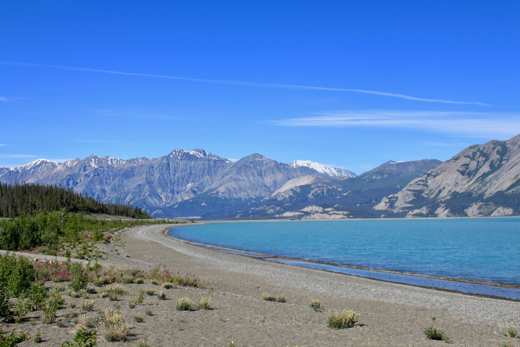
The Best 10-Day Itinerary for Canada’s Yukon Territory
April 27, 2021 // by Gwen Engler // 2 Comments
Looking for a travel destination that is truly off the beaten path? How about an impossibly beautiful land of rugged mountains, abundant wildlife, and mile upon mile of untamed wilderness? Allow me to introduce – or reintroduce – you to Canada’s Yukon Territory.

While I certainly adore Alaska and will always encourage people to visit, in a lot of ways the Yukon might be even better. The two have a lot in common – vast wilderness, much of the same flora and fauna, a shared history of gold fever and hardy pioneers – but the Yukon is less touristed, less populated, and was home to one of the greatest gold rushes of the 19th century. Its national and territorial parks are beyond stunning, and the scenic Alaska Highway – an incredible feat of engineering – cuts right through its center.
I’ve already shared ten reasons why the Yukon should be on your travel list , but now I want to make it even easier for you to head north with this ten-day Yukon itinerary! The plan includes the territorial capital of Whitehorse, the Alaska Highway, the unparalleled wonder of Kluane National Park and Reserve, the funky gold rush town of Dawson City, and more. It has everything you need for a once-in-a-lifetime trip to a once-in-a-lifetime place.
Now you just need to book your flights!
10-Day Yukon Itinerary at a Glance
Day 1 : Arrive in Whitehorse Day 2 : Travel the Alaska Highway to Haines Junction Days 3 and 4 : Kluane National Park Day 5 : Return and Explore Whitehorse Day 6 : Travel to Dawson City Day 7 : Dawson City Day 8 : Tombstone Territorial Park Day 9 : Dawson City Day 10 : Return to Whitehorse Other Things to Do in the Yukon Tips for Traveling in the Yukon
Day 1: Arrive in Whitehorse
Start your Yukon adventure by flying into the territorial capital, Whitehorse. Don’t worry if your flight schedule has you arriving late; you’ll be back for a full day of exploring in the middle of your trip. Plus, while there are certainly worthwhile things to do in Whitehorse, the real gems of the Yukon are located in the wilderness outside the city.
Whitehorse is a small, historic city with a gold rush past and a unique vibe. Stay downtown for easy access to the action, or choose a place outside the city to start reveling in the gorgeous landscapes.

Places to Stay in Whitehorse
- Northern Lights Resort & Spa . Cozy chalets with a spa and wellness center located twenty-five minutes outside of town. The outdoor hot tub is perfect for northern lights spotting in winter.
- Hidden Valley Bed and Breakfast . Comfortable four-room B&B offering exceptional breakfast and peaceful accommodations. Located twenty minutes from the city center near Takhini Hot Springs.
- SKKY Hotel . Located right across from the airport along the Alaska Highway with a free airport shuttle available. Convenient option for your first night in Whitehorse.
- Edgewater Hotel . With an excellent downtown location within walking distance of many attractions, Edgewater also boasts bright, airy rooms, complimentary WIFI, and a free airport shuttle.
- Raven Inn Whitehorse . Also conveniently located downtown, this family-owned boutique hotel has amazing views from its top floors.
Places to Eat in Whitehorse
- Klondike Rib and Salmon . Tasty joint downtown with some great wild game options. I tried musk ox and caribou for the first time here!
- Antoinette’s . Caribbean and Canadian fusion in a colorful, welcoming space.
- Baked Cafe and Bakery . The perfect spot to grab your morning coffee and pastry.
- Sanchez Cantina . Vibrant restaurant with delicious Mexican food.
- Giorgio’s Cucina . Solid Italian fare in the heart of downtown.
Day 2: Travel Alaska Highway to Haines Junction
It’s time to hit the road! First on your list of destinations is the village of Haines Junction, which is a little less than two hours west of Whitehorse along the historic Alaska Highway.

Also known as the Alaska/Canada Highway, ALCAN, or Highway 1 in the Yukon, the Alaska Highway runs from Dawson Creek, British Columbia and Delta Junction, Alaska. It was built during World War II to connect Alaska to the Lower 48 states in the face of the Japanese threat to the west coast of the USA, and the original highway was a remarkable feat of engineering, perseverance, and fortitude by the Army Corps of Engineers. These men battled extreme temperatures, permafrost, mosquitoes, isolation, rough terrain, and other harsh elements to complete 1,700 miles (2,700 km) of road in just seven months.
While you can certainly speed your way toward Haines Junction, I recommend taking a leisurely approach. Don’t hesitate to stop for photos, enjoy the scenery, and keep an eye out for moose, bears, and other wildlife.
If you’re willing to drive a little farther, gorgeous Kluane Lake is about forty-five minutes beyond Haines Junction. There’s a wide beach perfect for skipping rocks – we actually used to call the place “Skipping Rock” – and the excellent Thachäl Dhäl Visitor Centre is just a little further around the bend. There, you’ll find lots of information about the history and geography of the area, and Dall sheep are known to frequent the surrounding mountains. You can also hike the short (1 km) Soldiers Summit Trail to the site where the Alaska Highway was officially opened in 1942.

Places to Stay in Haines Junction
- Mount Logan Lodge . A ski-to-door property at the edge of Kluane National Park with on-site dining and excellent mountain views.
- Parkside Inn . Small bed and breakfast located on the outskirts of town. Kitchenettes are available in all rooms and you can access Kluane National Park hiking trails right on the property.
- Wanderer’s Inn Backpacker’s Hostel . The best budget option in town, Wanderer’s Inn offers dorm-style or private rooms within walking distance of Haines Junction amenities.
- Raven’s Rest Inn . Within walking distance of the Visitor Centre, this well-reviewed hideaway offers comfortable accommodations and adventure gear rental.
- Stardust Motel . Fairly standard motel-type accommodation along the Alaska Highway. Lovely mountain views and a wooden front porch add some charm.
Places to Eat in Haines Junction
- Village Bakery and Deli . Awesome little find with great breakfast, lunch, dinner, and treats. Especially great for sandwiches and baked goods. Try the budgie bars if they still have them!
- Mile 1016 Pub . Bar and pub food with mountain views.
Days 3 and 4: Kluane National Park
Your next two days should be devoted to one of the crown jewels of the Yukon Territory: Kluane National Park and Reserve . Pronounced “Kloo-ah-nee,” this massive swath of public land is home to the largest non-polar ice field on Earth, the highest mountain in Canada (Mt. Logan), stunning scenery, and tons of wildlife. Seventeen of Canada’s highest peaks are here, as well as excellent hiking, river rafting, and backcountry camping opportunities. It’s an outdoor paradise!

Tours can be arranged in Haines Junction but are best booked in advance.
Things to Do in Kluane National Park:
- Take a flightseeing tour . Seeing all those majestic mountains from the air is an experience you’ll never forget. It’s worth every penny.
- Go hiking . There are endless opportunities to explore the park on foot.
- Get out on the water . One of the best ways to experience the wilderness of Kluane is by rafting, kayaking, or canoeing.
- Visit Kathleen Lake . One of the most popular destinations in the park, Kathleen Lake is perfect for hiking, camping, or a picnic.
- Enjoy the winter. The fun doesn’t stop when the summer ends! Skiing, snowshoeing, snowmobiling, and other fun winter activities abound.
Day 5: Return and Explore Whitehorse
It’s time to get back to civilization… at least for a little while! Leave Haines Junction in the morning so that you can spend the afternoon enjoying Whitehorse. Tomorrow is a full day of driving to Dawson City, so the sooner you get back to Whitehorse the more time you’ll have to relax between car rides!

Things to Do in Whitehorse:
- Visit the Yukon Beringia Interpretive Centre . Excellent museum detailing the history of Beringia, the landmass the connected North America and Asia during the Pleistocene era, and its effects on the wildlife and peoples of both continents.
- Explore Miles Canyon . Gorgeous canyon with emerald water just south of town. You can view it from a highway pull off or explore on foot via hiking trails or a suspension bridge.

- Soak in the some hot springs . Located half hour from Whitehorse, these natural hot mineral pools are perfect for soaking away your stresses.
- Tour the SS Klondike . Before roads, sternwheelers were the main form of mass transportation in the Yukon. The Klondike was one of the largest and has been meticulously restored to allow visitors to experience that part of history right in downtown Whitehorse.
- See the fish ladder . This wooden structure helps migrating salmon circumvent the Whitehorse dam to reach their spawning grounds.
- Hike or ski some of the hundreds of kilometers of nearby trails . If you haven’t had enough hiking yet, or just want some different views of the city, there are plenty of trails in and around Whitehorse.
- Stock up on supplies for the rest of the trip . If you’ve forgotten or run out of anything, now is the time to stock up! Options may be limited (or more expensive) in Dawson City.
Day 6: Travel to Dawson City
Get ready for a full day of incredible scenery on your way to Dawson City! During your six-hour drive along the Klondike Highway, you’ll follow in the footsteps of Klondike Gold Rush “stampeders” who braved extreme weather, unforgiving wilderness, and innumerable other obstacles to make it to the gold fields near Dawson City. It’s a fascinating, if often overlooked, chapter in North American history, and there’s no better place to experience it than the Yukon.
While six hours may seem like a daunting amount of driving, there are some worthwhile landmarks along the way to break up the time, as well as unlimited opportunities for photo stops. About an hour and fifteen minutes into your drive, swing into Braeburn Lodge for coffee and a bathroom break. The food here is ginormous – try a cinnamon bun the size of a dinner plate or giant sandwich to get you through the next portion of your drive.
A half hour further north are the ruins of Montague Roadhouse , a log structure that housed and fed travelers in the early 20th century.

Twenty minutes beyond the roadhouse is the historic town of Carmacks , named after one of the people who first discovered gold in the Yukon. Stop in to learn about the town’s history or admire the views of the Yukon River from the waterfront boardwalk. Just north of town, the Tagé Cho Hudän Interpretive Centre offers great insight into the lives of First Nations peoples reaching back into antiquity.
One of the most scenic stops along the highway is Five Finger Rapids , which sits just off the road about fifteen minutes beyond Carmacks. Once one of the most perilous water passages on the journey between Whitehorse and Dawson, the area is now known for its remarkable beauty. Pull into the gravel parking lot and admire the views, which stretch across miles of untamed wilderness.

After Five Finger Rapids, you’ll mostly be passing through this vast, seemingly untouched wilderness. Keep your eyes peeled for moose (they love marshy spots), bears, and other wildlife! About two hours of driving will bring you to Moose Creek Lodge twenty minutes beyond the town of Stewart Crossing. This is a perfect opportunity to stretch your legs and grab a meal or a snack, browse the gift shop, and hit the bathroom. I am a personal fan of their baked goods, and their sausage rolls were always a big hit.

Roughly 100 kilometers beyond Moose Creek Lodge is a large pull-off to view the Tintina Trench , the largest geological fault in North America. I’ll be honest that I never really saw much of a trench (and I’m not a geologist), but it’s still an impressive landscape and good for a final stretch of the legs before heading into Dawson City. The viewpoint is at kilometer 655 and there are some big placards to help you understand what you’re seeing.

With the Tintina Trench in your rearview mirror, you’ll soon be pulling into Dawson City! Reward yourself with a hot meal and a cold drink and get ready for a few days of gold rush adventuring.
Places to Stay in Dawson City
- Aurora Inn . With a long-standing reputation for hospitality, the Aurora is a good bet for comfortable accommodations.
- Dawson City Bunkhouse . Budget option offering spartan but comfortable rooms steps from the Yukon River.
- Dawson Lodge . Newly-renovated, pet-friendly boutique hotel with great reviews.
- Dawson City Guesthouse . Excellent family-owned inn located away from the “bustle” of downtown near the confluence of the Yukon and Klondike rivers.
- Westmark Inn Dawson City . Large, well-kept hotel within walking distance of Dawson’s main attractions. I’ve stayed here with tour guests more times than I can count and it was always clean and comfortable.
- 5th Avenue Bed and Breakfast . Charming inn owned by the same proprietors of the Aurora Inn. I got to stay here once when the Westmark was full and it was a real treat!

Places to Eat in Dawson City
- Riverwest Bistro. Yummy breakfast, lunch, and coffee right along the river.
- The Drunken Goat Taverna . Fantastic Mediterranean and Greek food.
- Sourdough Joe’s . Bar and pub fare with possibly the best halibut and chips in the Yukon.
- Klondike Kate’s . Tasty appetizers, sandwiches, poutines, and entrees with some fun twists.
- Aurora Inn Restaurant . Dawson City-style fine dining and barbecue. Don’t skip dessert.
- Joe’s Wood Fired Pizza . Awesome pizza for those craving a break from pub food.
Day 7: Dawson City
After your long travel day yesterday, now is your chance to relax and enjoy this little city that’s like nowhere else on earth. Once known as “the Paris of the North,” Dawson’s history is as colorful as the buildings that line its streets. One of the best things to do in Dawson City is just wander around the town; it’s small enough to be completely walkable and there’s so much to explore! You’ll pass crooked buildings knocked sideways by permafrost, see a huge scar in the mountainside where an ancient landslide marred the bluff, witness the convergence of the Yukon and Klondike Rivers, and more.

While upwards of 30,000 people called Dawson City home during the height of the Gold Rush in 1898, today there are fewer than 1,500 permanent residents. (That’s still enough to make it the largest town in the Yukon after Whitehorse, though.) That said, there are tons of great things to do to occupy the two days you’ll spend here.
Things to Do in Dawson City
- Try your luck at Diamond Tooth Gertie’s . One of the most popular things to do in Dawson, Gertie’s is an old-timey gambling and dance hall offering three can-can/vaudeville shows a night during the summer season. The best part is that all proceeds from admission, the table games, and the bar benefit the local community.

- Tour the goldfields that started it all . Step into history by visiting some of the mines, goldfields, and gold dredges outside of town. You can even pan for gold! Many goldfields excursions include a historical tour of Dawson City as well.
- Hike to the Midnight Dome . For the best views of Dawson and her two rivers, make the trek to the top of the mountain overlooking the city. It’s well worth the climb.
- Join the Sourtoe Cocktail Club . Not for the faint of heart, the Sourtoe Cocktail Club is one of the strangest “organizations” you can join anywhere in the world. Visit the Downtown Hotel and take a shot of Yukon Jack whiskey with a preserved human toe tossed in. “You can drink it fast, you can drink it slow, but your lips have got to touch the toe” for your membership to count. Sounds weird and gross – and definitely is – but it’s a lot of fun.

- Visit the Gold Rush cemetery . Located just outside of town, this peaceful plot is the final resting place of dozens of prospectors and other townsfolk who came to Dawson from all over the world to seek their fortune.

- Explore Sternwheeler’s Graveyard . (Also known as Paddlewheeel Graveyard.) Across the river from Dawson City are the remains of multiple sternwheelers that can be visited at your own risk. Take the ferry and walk north along the river until you reach the wreckage. Please exercise caution, however, as parts of the wreckage may be unstable.

- Check out the Dänojà Zho Cultural Centre . This beautiful building along the river offers a fascinating glimpse into the lives, history, and customs of the Tr’ondëk Hwëch’in, the first peoples of the Klondike.
- Take a boat ride on the Yukon River . Enjoy a narrated, hour and a half-long tour up and down the river on the Klondike Spirit paddlewheeler.
- Visit the Robert Service cabin . Known as the “Bard of the Yukon,” Robert Service’s poetry evokes all the wildness, drama, peril, and emotion of the Klondike Gold Rush and the Yukon in general.
Day 8: Tombstone Territorial Park
Take a break from Gold Rush history today to visit Tombstone Territorial Park , a unique wilderness an hour and a half outside of Dawson City. There, you’ll have seemingly endless opportunities for hiking, wildlife spotting, fishing, winter activities, camping, and admiring the scenery of one of the most remote swaths of public land in the country.

While you can certainly drive yourself to the park, full-day tours are also offered from Dawson if you’d rather relax and let someone else take the wheel. Although you won’t have full control of your day, there’s a lot to be said for having an expert guide along to show you the sights. Not only will you learn a lot more about what you’re seeing, but local guides are excellent at spotting wildlife and can give you a much better appreciation for the history and topography of the area.
Note: You can visit Tombstone at any point during your stay in Dawson City, but I recommend doing it between two “local days” in and around town. This helps break up your long days on the road and provides a respite in between them.
Day 9: Dawson City
Enjoy your final day in Dawson City! It’s your last chance to hit any of those must-do activities before you head back to Whitehorse tomorrow.
Day 10: Return to Whitehorse and fly home
All good things must come to an end, and unfortunately that includes Yukon adventures. Make your way back to Whitehorse today (I recommend starting early to give yourself maximum time) and prepare to head home.
Other Things to Do in the Yukon
If you have more time or want to adjust this itinerary, check out some of the other great things to do during your time in the Yukon Territory:
Watson Lake and Signpost Forest
Almost five hours east of Whitehorse, on the border of British Columbia, is a town that’s a popular stop for tourists traveling the entire length of the Alaska Highway. Its most unique feature is the Signpost Forest, where tens of thousands of signs from towns all over the world are tacked onto innumerable posts. Stop in and add yours!
There’s also a lot of military history here from the days of constructing the ALCAN as well as some nice recreation areas.
Take a Day Trip to Skagway
A little over two hours south of Whitehorse is the American town of Skagway , which is one of my personal favorite places in Alaska. It was here that tens of thousands of prospectors arrived at the start of their Klondike adventure, and the town is loaded with history as a result.
Another reason to visit Skagway is that it is an absolutely gorgeous drive from Whitehorse with a lot to see along the way. Make sure to pull over for a photo at the impossibly scenic Emerald Lake, explore the dunes of the Carcross Desert (said to be the world’s smallest), swing into the colorful town of Carcross for some refreshment, and admire the stunning beauty of the White Pass on your way into Skagway. You can even take one of the greatest train rides in the world, the White Pass & Yukon Route , from Fraser or Skagway.

Make sure to take your passport, as you’ll be crossing an international border on the way!
Drive the Top of the World Highway
While the Alaska Highway is the more time-honored way to drive from the Yukon into Alaska, the road even less traveled leaves from Dawson City. Taking the ferry across the Yukon River deposits you on the Top of the World Highway, a long and lonely stretch of road through incredibly remote landscapes. It’s not for the faint of heart – the road is unpaved and there are some sheer drop-offs – but the views are stunning and it’s as off-the-beaten-path as it gets.
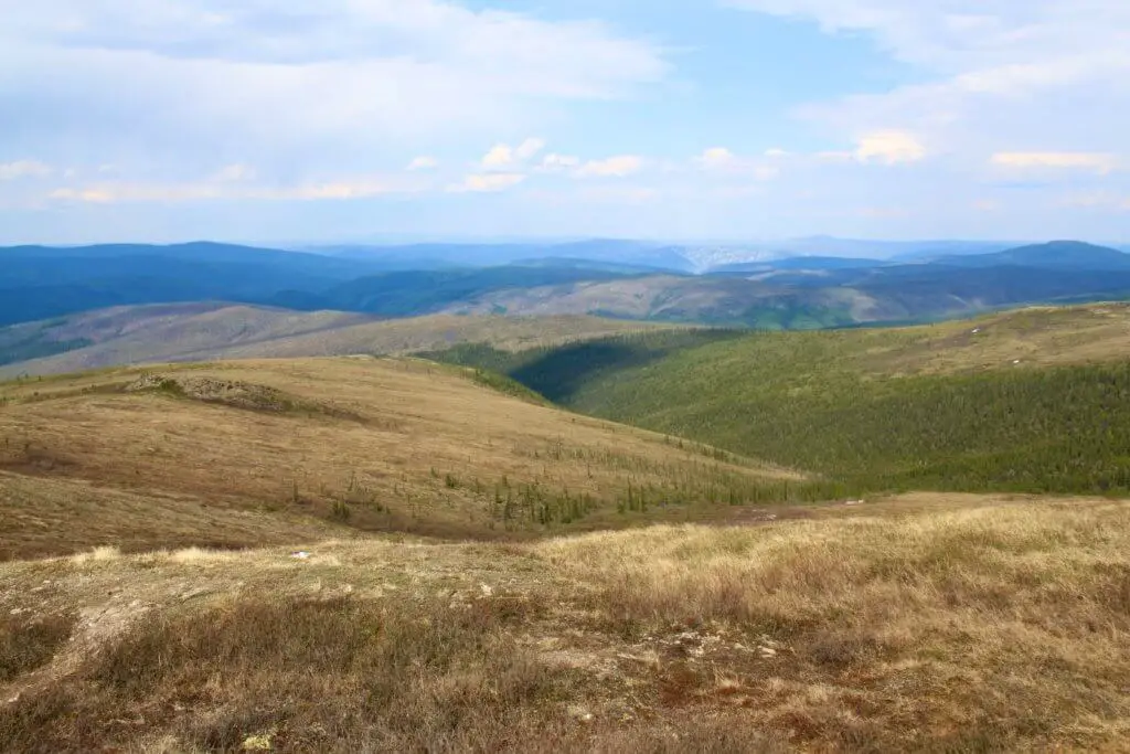
Tips and Helpful Information for Traveling in the Yukon
- It is absolutely essential to book accommodations in advance when traveling the Yukon in summer. Since many places have limited options, you don’t want to be stuck without a place to stay during high season! The same is true for any tours and activities that you absolutely do not want to miss.
- Please note that all travel times listed in this article are estimated and subject to delay. Weather, road conditions, flat tires, wildlife crossings, forest fires, and any number of other eventualities can easily add time to your drive. Make sure to plan accordingly.
- Similarly, delays and mishaps can happen on the long, lonely stretches of the Alaska and Klondike Highways, so it’s best to be prepared . Travel with snacks, water, an emergency kit, and plenty of gas. If you’re renting a car, this is not the time to decline extra coverage, as flat tires, cracked windshields, and other annoyances are common on the rougher parts of the road.

- If you want to spare yourself the long drive from Whitehorse to Dawson City, it is possible to fly between the two cities. The flight takes about an hour and fifteen minutes, as opposed to a six-hour drive. I recommend making the drive, however, as the scenery is breathtaking and you really get a sense of how remote the area is. You’ll also have a chance to spot wildlife like bears and moose along the way.
- The Yukon is a great place to witness the northern lights, or aurora borealis. Remember, however, to make sure to travel to the Yukon in the fall or winter if seeing the northern lights is a priority . During the spring and summer, the midnight sun prevents it from getting dark enough to witness the aurora.
- Be advised that while clean and comfortable, most accommodations in the far north are more rustic than you’ll find in the more southerly parts of Canada and the United States. You may encounter hotels without elevators or air conditioning, outdated furnishings, and a lack of four- and five-star options. Embrace the adventure!

Like the post? Pin to save or share!
10 Reasons Why the Yukon Should Be on Your Travel List The Ultimate 10-Day Alaska Itinerary Flashback Friday: Returning to Alaska
Need some help planning your Yukon itinerary? Full Life, Full Passport offers customized planning services for all kinds of vacations and budgets!
Want to be the first to know when a new post is published, or to receive exclusive content directly to your inbox? Join our email list!
Thanks for joining us! You'll hear from us soon. (Check your SPAM/junk mail if you don't.)

Reader Interactions

April 27, 2021 at 12:07 PM
UGH so many memories!!! Let’s go back 🙂

May 6, 2021 at 2:21 PM
I’m in whenever you are! I miss the Yukon like crazy.
Leave a Reply Cancel reply
Your email address will not be published. Required fields are marked *
Looking for Something?
All images on this site are the property of Full Life, Full Passport and may not be used without written permission.
Privacy Policy

How to Road Trip the Yukon on a Budget

Canada is home to some of the most pristine and unspoiled landscapes in the world. One of the country’s most scenic regions is the Yukon. In this guest post, writer Ethan Jakob Craft shares his tips and advice to help you road trip the region on a budget.
Tucked away in Canada’s northwestern corner is the Yukon Territory, a veritable paradise home to just 35,000 people and endless top-notch wilderness. The Yukon is dominated by thick boreal forest in the south and treeless tundra in the north and dotted with rugged peaks and lakeside beaches in between.
I first visited the territory at age 7 as a half-day shore excursion on an Alaskan cruise (yes, the border really is that close), and didn’t know what to make of it. But returning as an adult, it blew my expectations away.
Due to its sheer size and limited public transit options, I found the Yukon to be an ideal place for a Canadian road trip. Two weeks is perfect for covering the best of what the territory has to offer by car, taking you to both historic towns and untamed wilderness.
With a little bit of northern know-how, I took a summer road trip there on the cheap, and you can too using this handy guide that includes all of the territory’s most famous sights (plus some off-the-beaten-path excitement, too!).
Days 1–3: Whitehorse

I’d liken Whitehorse to an Austin or Portland of the North; it’s one of the hippest cities I’ve seen in Western Canada. With three days to enjoy, here are some things to do:
- Take in some local history — The four-story MacBride Museum of Yukon History downtown covers every aspect of the territory, with exhibits on the region’s wildlife, art, and Indigenous peoples; the Alaska Highway; and the Klondike Gold Rush, to name just a few.
- Hike Miles Canyon — South of town, the Yukon River has carved a deep canyon that is now home to a network of hiking and biking trails, all anchored by the Miles Canyon Suspension Bridge. According to almost every local I spoke to, the bright blue water here offers the most scenic view in town!
- Eat at the Fireweed Market — If you’re lucky enough to be visiting on a Thursday evening in the summer, swing by the territory’s largest outdoor market . It’s a delicious mix of food trucks, bakers, local artisans, and buskers that gives the markets in Toronto (my hometown) a run for their money. But get here early — some of the locals’ favorite treats can sell out quickly.
- Train with Iditarod sled dogs — Dog lovers, rejoice! In winter, head to the outskirts of Whitehorse to find a range of local sled-dog champions who are happy to offer kennel visits and training runs with a team of race-ready huskies. And don’t worry, you can still visit in the summer (just be ready to race in an ATV instead of a sled). I used Alayuk Adventures near Mt. Lorne and have nothing but praise for Marcelle and her dogs.
- Tour the S.S. Klondike — Now permanently dry-docked next to the river it used to ply, this historic touring ship operated by Parks Canada gives you the run-down on the long and haphazard history of Yukon River paddle wheelers, all while onboard one of the largest ones ever built.
Where to stay
- Town & Mountain Hotel — Like everything in the Yukon, lodging comes at a premium, though this hotel on Main Street appears to offer a fair deal at all times of the year, as well as free parking and an on-site lounge.
- Beez Kneez Bakpakers — The only true hostel in Whitehorse, Beez Kneez is full of perks, including free Wi-Fi, free coffee, laundry service, and a full kitchen.
Tip : Get gas before leaving major population centers. Not only can it be up to 50% more expensive at smaller stations in the backcountry, but you don’t want to risk running out of fuel in the Yukon wilderness. In the far north, you can drive hundreds of miles between gas stations, so fill up wherever you can.
Days 4–5: Dawson City

The drive to Dawson City can be done in as little as five hours from Whitehorse, but that’s without accounting for the numerous viewpoints, roadside hikes, and likely construction delays en route.
Here are a handful of things I’d recommend during your first of two stays in Dawson:
- Downtown Hotel — This property is one of the cheapest in town, and offers perks for guests. When I checked in, I got 2-for-1 drink coupons at its bar (the famed Sourdough Saloon) and a discount at the in-house Jack London Grill.
- Dawson City River Hostel — Situated in West Dawson, this is the northernmost hostel in Canada! Long a hit with backpackers (especially Europeans), it offers dorms, private rooms, a sauna, and even free bicycle parts. No credit cards.
Days 6-8: The Dempster Highway

The Yukon portion of the highway runs for about 300 miles (482km) through the Tombstone mountain range and endless pristine wilderness, crossing the Arctic Circle. While the drive was tough on both me and my vehicle, the sights and experiences along the way were worth it:
- Hike Tombstone Territorial Park — I think the most striking scenery on the Dempster Highway can be found just an hour into the drive, where you can enjoy jagged mountains and snaking rivers in this no-fee, off-trail territorial park. I stopped by the Visitor Center at kilometer 71 for all the information I needed.
- Stand on the Arctic Circle — There’s no better photo op to prove you experienced the True North than standing on the Arctic Circle, 30 minutes north of Eagle Plains, the only settlement in the area. Soon after, the tree line ends and you’ll be driving through barren tundra.
- See the Midnight Sun or Northern Lights — Depending on the season, you will likely be far enough north to see either 24-hour darkness and the aurora borealis, or 24-hour daylight when the sun never sets. Bring a flashlight or an eye mask accordingly.
- Watch wildlife — Black bears, marmots, foxes, moose, eagles, and herds of caribou so dense they darken the tundra are just a handful of the animals you might encounter on the Dempster Highway. Personally, I saw more wildlife on this stretch of road than I did in the rest of the territory combined. Binoculars are encouraged!
Tip : Prep your car! I cannot stress this enough: the Dempster Highway will batter your car, no matter how rugged it is. Axle-snapping potholes, shredded tires, and broken windshields are not uncommon. At best, you’ll get away with a layer of inch-thick mud. Experienced truckers recommend having at least one full-size spare tire, road flares, a satellite phone, and a 4×4 vehicle (though I did it with no issues in a four-door sedan). Check road conditions here .
- Eagle Plains Motel — This place isn’t cheap, but it is clean, warm — and your only lodging option for 250 miles in either direction.
- Camping — The Yukon government operates a handful of self-register campsites for both tents and RVs along the Dempster Highway. All government campgrounds are cash-only, but they are inexpensive and operate on the honor system.
Note : If you’re renting a car for your Yukon trip, make sure you are allowed to take it on the Dempster Highway — and any other unpaved roads, for that matter. Due to the route’s rough nature, some rental agencies charge an additional fee for Dempster driving, while others ban it outright. For the best deals, use Discover Cars .
Days 9–10: Dawson City

- Check out the Dawson City Firefighters Museum — Located at the north end of town, this by-donation museum houses more than a hundred years of Dawson City’s firefighting history. It’s overseen by a former local fire chief who gave me a very personal guided tour of the old trucks he once drove and the blazes he put out.
- Have a drink at Bombay Peggy’s — To celebrate the end of your Dempster Highway adventure, head for Bombay Peggy’s. It’s a fully restored brothel that serves the best mixed drinks and martinis in Dawson, according to every local I spoke with. And see if you can find out how Peggy got her nickname!
- Explore the “Paddlewheel Graveyard” — Along the riverbank in West Dawson, nearly a dozen paddlewheel ships from the early 1900s have been wrecked on the beach, offering photographers and urban explorers the chance to see some unique Yukon ruins. But don’t make my mistake: bring waterproof shoes if you have a pair.
- Press your luck at Gertie’s — There’s not a person in Dawson who won’t point you to Diamond Tooth Gertie’s Gambling Hall for a night of fun. Whether your vice is the casino (like me), the bar (like me), or the nightly can-can dance shows, there’s something for everyone under Gertie’s roof.
- The Bunkhouse — Centrally located, this historic hotel has free parking, the fastest Wi-Fi I used in the Yukon, and, if you’re really on a tight budget, smaller private rooms with shared bathrooms.
- Camping — Take the free 24-hour ferry over to West Dawson and pitch your tent (or park your RV) at the Yukon River Campground. It’s first-come-first-served, but because the site is one of the largest campgrounds in the territory.
Day 11: Faro

Cutting through some of the most unspoiled scenery in North America, this road is arguably more remote than the Arctic Dempster Highway — and depending on weather conditions, it can be even more of a challenge.
After a long day’s drive in the backcountry, your best choice is to overnight in Faro, a small mining community named after a card game . Here are some things to check out:
- Visit the Campbell Region Interpretive Centre — There’s no better place to learn the backstory of the Campbell River region and its eponymous explorer than this small-town museum and visitor center, located in the heart of Faro.
- Golf — Despite a population of just a few hundred residents, the layout of tiny Faro is unique, because there’s a nine-hole golf course running right through the middle of town. For an afternoon of fun, rent a set of clubs and hit the links at the Far North’s quirkiest green.
- Play the lottery — Once known for its zinc mining, the Faro of the 21st century has a new claim to fame: selling a $25 CAD million winning lotto ticket , the largest lottery win in the history of the territory. Years later, townsfolk were still telling me the story. Visit the Discovery Store, the only shop in town, and cross your fingers for a repeat!
- Faro Valley View B&B — This B&B’s rates vary with the seasons but never go higher than around $100 CAD in peak season (in winter, rates are about half that). Satellite TV, Wi-Fi, and snacks are all included in the price.
- Airbnb — While Airbnb hosts are few and far between in this part of the Yukon, I suggest checking out this hidden gem outside of Faro. An off-the-grid cabin situated in true wilderness, this rustic stay offers homemade baked goods, canoe rentals, and even a vegetable garden to eat from.
Day 12: Watson Lake

- Cross the Ross River Suspension Bridge — Built in the 1940s to support the ill-fated Canol Pipeline, this wooden suspension bridge towers over one of the only other towns on the Campbell Highway. Here, the only signs of human civilization are the rusting hulks of trucks and cranes once used to build the pipeline. Required listening: “Canol Road” by legendary Canadian folk singer Stan Rogers.
- Learn about the Northern Lights — In the winter, Watson Lake is one of the most popular places in the territory to view the aurora borealis. But whether or not you’re around to see them in the sky, you can learn about this dazzling phenomenon year-round at the local Northern Lights Centre.
- Wander the Sign Post Forest — Any local will tell you, this is the town’s best attraction. Started by a homesick soldier who first posted a sign pointing to his hometown in Illinois, this literal forest has grown to include tens of thousands of road signs, license plates, and other markers from around the world. As a world traveler and license plate collector, this was my version of heaven.
- Add a sign — It’s not just permitted to leave your mark on the Sign Post Forest, it’s encouraged! Whether you bring a souvenir sign from home or create your own at the visitor center’s small sign-making station, travelers passing through are the ones who keep this attraction growing.
- Air Force Lodge — Located in refurbished World War II barracks, this hotel offers one of the best deals in town, with reasonably priced private rooms (most have shared bathrooms).
- Stampeder’s B&B — This B&B is located in the heart of town and is within walking distance of all shops, restaurants, and attractions.
Days 13–15: Whitehorse

- Visit the George Johnston Museum — Located on the shores of Teslin Lake, about halfway between Watson Lake and Whitehorse, this small-town museum focuses on the lives of the local Tlingit Indigenous people and is highly informative.
- Swim in the Takhini Hot Pools — These steaming hot springs have been in operation for over a hundred years, warming locals and tourists alike in chilly Whitehorse. If you visit on a day when the temperature is at least -20°C, be sure to enter the Hair Freezing Contest for a chance to win $2,000 CAD.
- Take a day trip to Carcross — This is where at age 7 I first laid eyes on the Yukon. With some time to spare, take a trip to this quaint town 45 minutes south of Whitehorse. The terminus of the scenic White Pass & Yukon Railroad that connects to the Alaskan coast, Carcross also lays claim to the oldest store in the Yukon and a patch of sand dunes billed as the world’s northernmost desert.
- Drink at the Yukon Brewing Company — In the world of craft brews, the Yukon Brewing Company is known as one of the most prolific brands in Canada’s north. Ales, lagers, and IPAs are all on offer at this famous Whitehorse brewery.
- Hot Springs Hostel — This year-round hostel is located next to the Takhini Hot Pools and guests get 20% off.
This two-week itinerary covers almost all the Yukon has to offer in a reasonable amount of time, but, for the true outdoorsman or dedicated explorer, there is much more than can be seen with an additional week: Canada’s highest mountain in Kluane National Park, a perfectly preserved mining town at Keno City, and the scenic White Pass & Yukon Railroad into Alaska, just to name a few.
Yukon is one of the least explored and most underrated parts of Canada. It’s the perfect place for a road trip, to get away from the crowds, and to get closer to nature. Enjoy!
Ethan Jakob Craft is a journalist, dual American-Canadian citizen, and lifelong traveler who visited all 50 U.S. states before he could legally have a beer in any of them. Recent trips have taken him to the Arctic Circle, Mexico, Morocco, and the Azores in his long-term quest to visit every corner of the globe. Ethan is currently based in Toronto, Canada.
Book Your Trip to Canada: Logistical Tips and Tricks
Book Your Flight Use Skyscanner to find a cheap flight. They are my favorite search engine because they search websites and airlines around the globe so you always know no stone is left unturned.
Book Your Accommodation You can book your hostel with Hostelworld as they have the biggest inventory and best deals. If you want to stay somewhere other than a hostel, use Booking.com as they consistently return the cheapest rates for guesthouses and cheap hotels.
Don’t Forget Travel Insurance Travel insurance will protect you against illness, injury, theft, and cancellations. It’s comprehensive protection in case anything goes wrong. I never go on a trip without it as I’ve had to use it many times in the past. My favorite companies that offer the best service and value are:
- Safety Wing (for everyone below 70)
- Insure My Trip (for those over 70)
- Medjet (for additional repatriation coverage)
Need an Affordable Rental Car? Discover Cars is a budget-friendly international car rental website. No matter where you’re headed, they’ll be able to find the best — and cheapest — rental for your trip!
Looking for the Best Companies to Save Money With? Check out my resource page for the best companies to use when you travel. I list all the ones I use to save money when I’m on the road. They will save you money when you travel too.
Want More Information on Canada? Be sure to visit our robust destination guide on Canada for even more planning tips!
Photo credit : 6 – Susan Drury
Got a comment on this article? Join the conversation on Facebook , Instagram , or Twitter and share your thoughts!
Disclosure: Please note that some of the links above may be affiliate links, and at no additional cost to you, I earn a commission if you make a purchase. I recommend only products and companies I use and the income goes to keeping the site community supported and ad free.
Related Posts

GET YOUR FREE TRAVEL STARTER KIT
Enter your email and get planning cheatsheets including a step by step checklist, packing list, tips cheat sheet, and more so you can plan like a pro!

The Best Yukon Road Trip Itinerary with our CanaDream RV
Sep 1, 2022 | 0 comments

Often, where we travel dictates how we travel. Some destinations are perfect for choosing a “home base” to explore from. But there are a few locations that we’ve found where booking a camper van or RV is almost essential to truly experience it properly.
Iceland? Definitely need an RV. New Zealand? Can’t do it without one. And now we’ve discovered another place where having an RV drastically enhances your trip; the Yukon.
With its wide-open spaces and dramatically changing landscapes, the Yukon was built for RV trips. Not only is there a lot to see, but everything is connected by absolutely beautiful drives, including the Alaska Highway, the Dempster Highway and the Klondike Highway. It’s hard to keep your eyes on the road!

With only a week to explore, we decided to cram our itinerary chock full of activities, learning a ton about what to do and what not to do along the way.
Our #1 “do”? Rent an RV!
The vehicle we were lucky enough to have on this adventure was the CanaDream Maxi Travel Camper which was an absolute dream to drive and perfect for just the 2 of us.
The camper comes with a Queen bed setup, fully equipped kitchen, plenty of wardrobe space and a washroom/shower. CanaDream also supplied camping chairs, which were fantastic to have.
While learning to drive a camper or RV can require a bit of a learning curve, the Maxi Camper made it super easy, as it was quite similar to the large SUV we drive at home. With it’s high ground clearance and 4wd capabilities, we felt ready to tackle anything the North had to throw at us.
I’ve outlined our week-long itinerary below, which can be used as a rough guide to planning your own Yukon road trip. I’ve included the hikes we did, where we stayed, driving distances, and all the hidden gems we discovered along the way.
Day 1: Whitehorse – Gathering supplies
We picked up our RV at the new CanaDream station located conveniently in Whitehorse.
We didn’t realize that our booking came with a shuttle service from the Whitehorse Airport. I received a phone call as we were on our way to the airport, confirming our flight number and time of landing – a very pleasant surprise!

Whitehorse is the perfect place to ready yourself for a big camping/RV trip. They have outdoor stores, gear rental shops, big grocery stores, bakeries, and just about anything else you could want for the road.
Things we picked up for our trip: an inflatable SUP rental, lots of camping food (smokies and s’mores!), and one last hot meal before our foray into the wilderness. Oh, and lots of mosquito repellent because we had heard numerous times how bad the mosquitos are in July.
From Whitehorse, we headed to our first campground: Caribou RV Park located a short 15 minute drive from town.
Total drive time: 20 minutes
Day 2: Carcross Region – Paddy Peak and Emerald Lake
The Yukon is known for its hiking so we felt like we needed to start the trip off with a big one. Paddy Peak is actually located in British Columbia, but was in all the Yukon hiking guides we picked up and it looked spectacular!

We were met with an ice blue lake with large icebergs floating around on the surface. Purple wild flowers framed the sides and added a nice pop of colour. It was absolutely stunning, but with Paddy being the highest peak in the range, it seemed to create its own weather system and was obscured by clouds the entire time we were there. A beautiful hike nonetheless.

Note: with a 4×4 and enough clearance (basically if you have an ATV), you can actually drive the majority of the road into Paddy Peak. Expect very rough terrain. We obviously did not try this with our CanaDream camper.
Hike stats:
Distance: 17.5 km round trip Elevation gain: 957 m
Round trip time: 6.5 hours
After our hike, we decided to spend the rest of the afternoon paddling on Emerald Lake. This is the most photographed lake in the Yukon and for good reason – it’s vividly green, especially from up above! We sent our drone up to capture the magic and I’ll let the photos do the talking.

Where we stayed: Caribou RV Park
Where we ate: Even though we had camping food, we couldn’t resist dining at Wolf’s Den Restaurant which was located very conveniently within Caribou RV Park. Originally, we had popped in to purchase some Yukon beer, but saw their expansive menu and just had to stay!
Total driving time: 2 hours round trip
Day 3: Carcross Region – Carcross Desert and Caribou Crossing Trading Post
While driving to Paddy Peak the day before, we caught glimpses of sand dunes right off the side of the highway and our interest was piqued. Turns out, we were driving past Carcross Desert, one of the smallest deserts in the world.

It’s truly baffling to travel so far North and encounter this natural phenomenon. The sand felt so good on our aching feet as we trekked barefoot across the dunes. With snow capped mountains in the distance, I have to say this is one of the most unique locations we’ve ever encountered!
Sandboarding is a popular pastime at this location and as an avid snowboarder, I was a little disappointed that we hadn’t planned ahead and brought some gear with us!

But I didn’t have much time to be sad, as our next stop involved puppies… husky puppies!

Caribou Crossing Trading Post gave us a little taste of Yukon wildlife, culture and history. There’s everything there from dog sledding, Klondike Gold Tours, an animal museum, old time ice cream parlour, and much more!

We loved our visit here and the staff were extremely knowledgable and friendly.

Where we ate: Caribou Crossing Trading Post Total driving time: 1 hour round trip
Day 4: Kluane National Park – King’s Throne Peak
The moment we saw King’s Throne on the cover of a Yukon hiking map, we knew we had to do it. While the stats can be a little daunting, I knew it would be worth it… and I was right. This is definitely one of the most epic hikes we’ve ever done. As crazy as the views were on the way up, nothing could have prepared me for the view at the summit, which happened to be hidden from view until the very last moment.
King’s Throne Peak is a must do if you’re visiting Kluane.

Most people we shared the trail with turned around at the saddle, probably because it was one of the windiest hikes we’ve ever been on.

Hike stats (to the “seat” of King’s Throne)
Distance: 10km round trip Elevation gain: 548 m Round trip time: 4-6 hours
Hike stats (to King’s Throne Summit)
Distance: 16 km round trip Elevation gain: 1,258 m
Round trip time: 6-10 hours

While we had originally planned to paddle on Kathleen Lake after our hike, it was way too windy and we were honestly way too tired to do anything else but crawl into the back of our camper. The second we got to our campground, it started pouring rain which made us feel better about bailing on our plans. We fell asleep to the sound of raindrops on the roof and were both extremely grateful we weren’t tent camping.
Where we stayed: Pine Lake Campground Where we ate: Frosty’s Restaurant Total drive time: 2 hours 45 min
Day 5: Kluane National Park – Kluane Glacier Air Tour
With how windy it was the day before, we were a little concerned that our glacier flight on this day would be cancelled. Luckily, we woke up to blue sky and not a stitch of wind.
Heading to Haines Junction Airport, we checked in for our 1 hour glacier flight seeing tour with Kluane Glacier Air Tours. This tour was absolutely mind-blowing and if I could recommend just one thing to do in Kluane National Park, it would be this.

As we flew deep into the mountains, we not only witnessed several incredible glaciers, but caught glimpses of wildlife as well! Our pilot had an incredible eye for mountain goats and we saw over a dozen of them from up above.

Once again, I’ll let the photos do the talking, as nothing I say will do this spectacular landscape any justice.

With our feet safely back on the ground, we decided we had a choice. Stay and explore more of Kluane, despite the increasingly windy conditions and looming rainfall, or return to Whitehorse where the weather looked significantly better. I have to say this is one of my favourite things about traveling in a CanaDream camper. It is an absolute breeze to change plans at the drop of a hat, without having to cancel and rebook hotels, find a place to stay for the night or feel like you’re stuck in one place. The freedom it gives you to explore at whatever pace you want is unmatched.
In the end, Whitehorse won, and we headed back to explore more of Yukon’s capital city.
Where we stayed: Free RV parking in Whitehorse, near the river/train station. Parking here is limited but this is one of the city’s best kept secrets. Whitehorse on the whole is extremely RV friendly and we had absolutely no trouble navigating the busy streets.
Where we ate: Azhong Noodles, an inconspicuous food truck parked across from the MacBride Museum, which had the absolute best hand-pulled noodles I’ve had (including Asia!)
Total driving time: 2 hours
Day 6: Whitehorse – Yukon Wildlife Preserve, MacBride Museum, Grey Mountain Hike
With our legs still aching from the big hikes we had done, we decided to get our steps in through a much less strenuous activity: the 5km walk around the Yukon Wildlife Preserve, located just 20 minutes outside of Whitehorse.
We were able to observe bison, moose, caribou, foxes, mountain goats and other local animals from a safe distance, as we walked around the absolutely enormous preserve. We learned a few interesting facts, including our favourite one – that the Yukon has twice as many moose as people!

Heading back to Whitehorse, we contemplated doing a short hike, but our legs were still not quite ready. So we decided to indulge in a bit of culture and history at the MacBride Museum. If you’re visiting the museum, definitely plan to spend a couple hours here. It covers everything from the gold rush, the Indigenous way of life, and the events that shaped the Yukon as it stands today.

Feeling hungry, we decided to give the one restaurant everyone had been raving about a try. Klondike Rib & Salmon is located in downtown Whitehorse and we felt like we had stepped back in time to an old saloon in the middle of the gold rush. The food was extremely hearty and the portions were absolutely enormous and by the time we left around 6pm, there was quite the line-up outside. Go early if you can, they don’t take reservations!
While the Kluane and Carcross regions are known for their hiking and incredible views, we thought we would give the hikes around Whitehorse a chance as well. We were more than surprised to discover a unique trail with gorgeous sunset views located very close to the city.

The Cave on Grey Mountain is basically a 1 km hike that goes straight up and is extremely steep. Luckily, the grind is over quickly and the cave offers some spectacular views of Whitehorse below.

Distance: 2km round trip Elevation gain: 200m Round trip time: 30 minutes
Where we slept: Our new favourite spot, the free RV parking in Whitehorse
Total driving time: 1 hour
Day 7: Time to head home
Time to pack up and go home! We were very reluctant to end this trip, every single day was perfect and the Yukon absolutely has a special place in our hearts.
The drop-off process with CanaDream was quick and easy and they kindly offered once again to shuttle us back to the airport. I truly don’t think this trip would have been close to what it was had we not had our camper. The freedom, flexibility and convenience made everything so much better and we can’t wait to return for more adventures in one of our new favourite destinations.
This post was kindly sponsored by CanaDream and Travel Yukon. All experiences and opinions are our own.

Written by Louise
Canada | north america | road trip | yukon.

Hi, we’re Rob and Louise! We’re obsessed with travel and love to share our adventures! We’re a UK/Canadian couple that currently lives Banff, Canada.
Popular Categories
- North America
- Winter Activities
11 Reasons to Visit Silver Star Mountain Resort in Winter
The ultimate 8 day idaho hot springs itinerary.
- A guide to Visiting Caracol; Belize’s Ancient Mayan City
You might also enjoy:

Sunshine Village Heated Chairlift (Teepee Town)

7 Things to do in Lake Tahoe

Big Mountain Skiing at Revelstoke Ski Resort

The Mount Baldy Hike in Kananaskis: Hiking the West Peak for Sunrise
You may also like….

When you live in the Canadian Rockies, you're absolutely spoiled for choice when it comes to ski resorts, but we're...

Lately, we’ve been really focused on discovering what’s in our backyard but, despite being directly below us,...

The Best Restaurants and cafes in Lake Louise – The Local’s Guide
As we have probably mentioned in previous blog posts, we like to think we know Banff and the Bow Valley extremely...
Submit a Comment Cancel reply
Your email address will not be published. Required fields are marked *
Save my name, email, and website in this browser for the next time I comment.
Submit Comment

Navigate forward to interact with the calendar and select a date. Press the question mark key to get the keyboard shortcuts for changing dates.
Navigate backward to interact with the calendar and select a date. Press the question mark key to get the keyboard shortcuts for changing dates.
Yukon Trip Planner
Top destinations in yukon.

Top attractions in Yukon

Other notable attractions

Top searches in Yukon
Explore nearby places.
- Pelly Crossing
- Dawson City
- Burwash Landing
- Destruction Bay
- Haines Junction
- Eagle Plains
- Fort Good Hope
- Fort McPherson
- Watson Lake
- Glacier Bay National Park and Preserve
All related maps of Yukon
- Map of Yukon
- Map of Mayo
- Map of Pelly Crossing
- Map of Faro
- Map of Carmacks
- Map of Ross River
- Map of Dawson City
- Map of Whitehorse
- Map of Champagne
- Map of Burwash Landing
- Map of Destruction Bay
- Map of Haines Junction
- Map of Marsh Lake
- Map of Eagle Plains
- Map of Eagle
- Map of Chicken
- Map of Tagish
- Map of Carcross
- Map of Tetlin
- Map of Teslin
- Map of Fort Good Hope
- Map of Atlin
- Map of Fort McPherson
- Map of Skagway
- Map of Haines
- Map of Yakutat
- Map of Watson Lake
- Map of Glacier Bay National Park and Preserve
- Map of Inuvik
- Map of Gustavus
- Map of Juneau
Yukon throughout the year
- Yukon in January
- Yukon in February
- Yukon in March
- Yukon in April
- Yukon in May
- Yukon in June
- Yukon in July
- Yukon in August
- Yukon in September
- Yukon in October
- Yukon in November
- Yukon in December
Q&A about Yukon
Add places from guides with 1 click, collaborate with friends in real time, import flight and hotel reservations, expense tracking and splitting, checklists for anything, get personalized suggestions.
4.9 on App Store, 4.7 on Google Play
- United States
- New Zealand
Yukon and Alaska Road Trips

Our Yukon and Alaska Road Trips offer the most freedom from civilization, with open roads, sprawling national parks and more wildlife than people.
Filled with an immense wilderness and colorful history, these ‘last frontiers’ offer true and unaltered beauty in the form of mother nature herself., travel from whitehorse to kluane national park and visit canada’s tallest mountain, or watch majestic mammals up close at the yukon wildlife preserve..
While rustic at times and some roads are unpaved, we know how to make these road trips special.
Ask us about our scenic flight to the Canadian Arctic and toast champagne at the Arctic Circle.
Showing results for Yukon and Alaska Road Trips
Canada Road Trip REVIEWS
"Thank you for the wonderful job you did in setting everything up, and also for your courteous assistance."
Nick Florida, United States
"From day one we felt comfortable that everything was going to be special."
Mark Australia
"Thanks Canada by Design for putting together and planning such a trouble free, smooth running package."
Lutfu Istanbul
"We cannot thank everyone enough for their professionalism and organisational skills."
Hazel Scotland
"We just came back from our winter adventure 5 days/4 nights in Whitehorse, Yukon, Canada. We had such a nice time and everything was great."
Ina Dominican Republic
"We did the "Rail & Drive Across Canada" with you & it was wonderful. A Bucket List dream come true!"
Rita Illinois, United States
"Thanks for a great holiday. The Rockies - awesome, Victoria- beautiful. Whistler- magic."
Mark Sydney, Australia
"Thank you so much for a wonderful vacation that created memories for our lifetime! You did a great job!"
Pam Illinois, United States
"Thanks again, we would certainly recommend you to our friends in Florida!"
Thomas Florida, United States
"It was like a Christmas tree fairyland. It was snowing pretty good. So coming from Texas in the summer it was really special, almost magical. "
Anita Texas, United States
"We had a wonderful trip and everything was arranged very well!"
Jacqueline Netherlands
"They not only tailored my itinerary to include activities I liked, but also made my car and hotel reservations, making it no-fuss for me. "
Annette California, United States
"The way we were able to customize our trip drive/train and explore on our own was awesome! "
Melinda Nevada, United States
"Thanks very much to Jasmine for helping to organise our wonderful holiday from Vancouver across the Rockies to Calgary."
Graham Perth, Australia
"It was a very memorable trip and I highly recommend to all."
Cherie Arizona, United States
"I would definitely recommend this to anyone - but especially to young parents with families. "
Annabelle Delaware, United States
" The whales very kindly decided to perform when I was whale watching. "
Janet New Eltham, United Kingdom
"Excellent trip. Well planned out. We were able to get all our additional destinations accommodated. "
Paul Williams Canada
"One of our best vacations. Perfectly planned and all went off without a hitch. "
Joel Yellin Rochester , United States
"We could not have been more pleased with the trip that was planned by Canada by Design."
Carol Cevolani Petaluma, United States
"We found our experience with Canada by Design to be most wonderful for our Trans-Canada Rail Trip."
Marjorie Stock California, United States
"We would recommend trips organized by Canada by Design to anyone who is interested in actively exploring parts of the country."
Astrid Ottawa, Canada
"It was a dream come true, I am so happy! "
Joanne Massachusetts, United States
"We had the most fabulous trip to our Winter Wonderland in the Canadian Rockies."
Mary California, United States
"I don't know how I will ever thank you all at Canada by Design for making our trip of a lifetime!"
Ann Australia
"From start to finish it was an ideal trip for us to enjoy Canada scenery, atmosphere and hospitality. "
Manuel United States
"This was an A++ experience! I'll definitely use Canada by Design for our next trip to Canada."
Kathleen Texas, United States
"We had a marvelous trip. Everything fell into place."
Anne New Jersey, United States
"Destinations, itinerary and accommodation was all well thought out and we had a very memorable time. I'd happily use Canada by Design again."
Christopher Zurich, Switzerland
"The staff at Canada by Design could not have been more helpful and friendly."
Clive New South Wales, Australia
"There isn't anyone I would rather use for travel to Canada."
Emily Tennessee, United States
"I highly recommend this company, They will tailor a trip to meet individual needs."
Mel New Zealand
"I would highly recommend Canada by Design and would certainly use them again when going to another area they service."
Joyce New Jersey, United States
"Every part of our trip was well thought out and there were no hitches."
Di New Zealand
"From start to finish Jennifer was very polite and easy-going as well as professional. She offered suggestions when needed and and was on top of all itinerary adjustments and refunds. "
Kim Pennsylvania, United States
"Thanks again for a well planned and hassle free vacation. We will look forward to future vacations with Discover Holidays. "
Ross Ontario, Canada
"Paulina organized an awesome trip for us which included Vancouver Island and the Rockies."
Peter Australia
"Overall it was a great way to see the country for the most part. "
Lorraine Squamish, Canada
"We came back with many happy memories and beautiful photos of your breathtaking country."
Johanna Oswald Little Rock, AR, United States
"My clients and myself most definitely benefited from working with Canada By Design! "
Amanda Central Travel
" We would highly recommend Jennifer and Canada by Design for all of your travel needs. We count ourselves very lucky that we found this 5-star team of travel experts!"
Julie Cass Brisbane, Australia
"It was such a relief to know that we could trust Canada by Design before and during our trip."
Vered Mei-Tal Lutherville, United States
" I couldn't be more pleased with the trip! "
Marlene Schillinger Petersburg, Virginia, United States
"Our trip through western Canada planned by Canada by Design was fabulous."
Jeffrey California, United States
"We will be recommending you to others and will use you again when we return for more adventure."
Kay New Zealand
Speak to a Travel Designer
Call 1 800 217 0973 US or Email us
The grand Yukon RV road trip – 25 things you must know

Parks Canada campgrounds in Yukon are postcard awesome. Fox Lake, north of Whitehorse, is one of our personal favourites (photo: Brook James).
Last updated . 29 January 2020
It may be an adventurous road trip, but it doesn’t have to be a bumpy ride. Here, our Yukon expert, Steve Madgwick , shares his tips on how to make your Grand Yukon RV Road Trip a smooth one.
It’s astounding how much you learn on a 3000-kilometre road trip, driving an eight-metre long, three-metre high, 6.5 tonne RV on some of this planet’s most remote roads.
Alaska gets all the bucket-list love, but Canadian next-door neighbour Yukon shares the same latitude, same mountain ranges, same animals but with a personality all its own. In the summer months, the ‘larger than life’ history, cultures and huge horizons make for one of the best road trips on Earth. The Yukon’s scale and sheer remoteness can seem daunting at first, but don’t let that stop you. Please.

The one issue you will not have on a Yukon road trip is finding your own space (photo: Brook James).
After two weeks driving under the Midnight Sun (past the Arctic Circle), I reckon I am a pretty much an expert now. So here’s everything you need to know about your Grand Yukon RV Road Trip.
Which route should I drive?
1. the classic loop: whitehorse-klondike-alaska-kluane-whitehorse.

One of the last things you’ll pass if you drive the classic Yukon loop is Kluane National Park. And what a crescendo it is… (photo: Brook James).
You can drive this 1500-kilometre loop in five days, but push it out to two weeks to give yourself time to appreciate Yukon’s nuances. Start in capital Whitehorse; head north up Klondike Highway to Dawson City; west over Top of The World Highway to Chicken, Alaska (unsealed road); head south and re-cross the border into Yukon; south to marvelous Kluane National Park ; then finish the loop back into Whitehorse.
2. The Arctic Circle side-trip
If you’ve time and an adventurous spirit, branch off the classic loop up and back down Dempster Highway (unsealed) to the Arctic Circle, and beyond to Inuvik (Northwest Territories). This is Ice Road Trucker territory in winter, but in summer its highlights are infinite ( Read: The Arctic Circle road trip ). Other more laid-back add-ons include the Southern Lakes loop (Carcross, Tagish, Marsh Lake) and The Silver Trail side-trip to Keno and Mayo.

Before you leave Whitehorse on your great Yukon RV road trip, gather as much information and supplies as you can carry (photo: Brook James).
Before you leave Whitehorse…
3. do a big shop.
Yukon’s capital is endowed with all the services you’ll need, from supermarkets to Starbucks. Use them. You can buy most incidentals in village roadhouses, but the choice dramatically shrinks and costs explode the further you are away from the city.
4. Some pre-road-trip R&R
Jet-lag and RV road trips don’t play well together. Plan at least one prep/rest day in Whitehorse to get your bearings before you hit the road. Drop by the Visitor Information Centre for the good oil on road conditions et al, check out the sites and, most importantly, get a good night’s slumber.
5. Make sure you’ve packed…
Yukon’s summer temperatures range from brisk to hot so bring your coolest sunglasses and hat, plus throw in sunscreen and mosquito repellent (you’ll thank me later). Conversely, pack rain gear and layers for warmth, especially if you’re heading far north. Sort out playlists, too, because there isn’t great phone or radio reception where you’re going.
6. If in doubt, fill up

Always ask where the next gas pump is… distances are BIG in the Yukon and the fuel stops few (photo: Brook James).
Yukon’s settlements are well and truly spaced apart, so every time you pass a petrol station, ask yourself, “where’s the next one?”. Fuel prices in Dawson City and Whitehorse are on par with the rest of Canada, but ‘isolation tax’ bites in remote corners (remember, RVs have huge tanks to fill!).
How to drive an RV for first-timers
7. it’s okay to be the slowest thing on the road.

RVing the Yukon is all about embracing life in the slow (and windy) lane (photo: Brook James).
Despite their torquey engines, RVs are always the tortoise, never the hare. Ninety-nine times out of 100 you will be the passee not the passer. Cars will occasionally bank up behind you; it’s up to them to pass you . Get used to this and you will enjoy the drive a lot more.
8. Driving by mirrors
Learn how to use you mirrors before you leave the rental lot. Because of their length, which cause gaping blind spots, RV’s rear-view mirrors are split into two: the bottom half shows close cars, the top shows those approaching from afar. (The windscreen-mounted mirror is useless.) Mirrors are also the best way to ensure the wide beast is in its lane. Tip: Don’t stress, the Yukon’s wide-open roads make for a forgiving environment.
9. The art of RV steering
Obviously a long wheelbase vehicle needs more room to turn than a car. Most rentable RVs are less than nine metres (unlike the Winnebago whales you’ll see) so it’s just like driving a really big car. Simply allow a wider turning ark and use your mirrors to check that you aren’t curb-cutting with your rear tyre. Be prepared to execute four- and five-point turns instead of the usual three. (Check out YouTube for masterclasses.)
10. Chill on hills
The Yukon’s roads cut through endless mountains and valleys, meaning you have to deal with steep gradients in a vehicle the weight of a small truck. There are a few things to know: slow down before (not on) a hill; select a low gear if the incline looks precarious; then chug calmly down it.
11. The reversing partner
Whenever you don’t feel 100 per cent confident reversing the beast, it is your passenger’s sworn duty to get out and help. Your reversing-angel should stand in clear view of one of your mirrors and use obvious hand signals to help you ‘land’. (Note: Always look up for obstructions, too.)
12. Don’t forget to unplug
Do a final walk-around your RV every time you drive out of a campground! It’s amazing how many stories you hear about power boxes and water connections being dragged down the road. Remember to close your ‘pull-out’ too.
RV Life: there are no stupid questions
13. what’s inside an rv.
RV life is about self-sufficiency. The ‘Midi’ motorhome we rented (see No. 22) sleeps four comfortably and has everything, including the kitchen sink: a (small) shower, toilet, propane stove, fridge/freezer, conventional oven, microwave, television, electric ‘pull-out’, on-board generator, solar panels and much more!

The best thing about learning to drive an RV in the Yukon is the forgiving wide, open roads (photo: Brook James).
14. Yukon’s campgrounds are postcard awesome
Parks Canada provide some of the most stunning campground settings in the free world. My fave is Fox Lake (north of Whitehorse) for its sheer reflective-lake prettiness. The secluded, well-maintained sites offer only basic facilities (clean long-drop loos, free firewood etc.) for well under twenty bucks a night. (Tip: it’s first-come, first-served so turn up before 11am when other RVers tend to move on.)
15. RV parks: pump and dump
Each decent-sized town has at least one commercial RV park, mandatory so you can ‘plug in’ to recharge batteries and refill drinking and shower water (and to dump waste water). You only need to stay in one every few nights; generally they don’t have the same charm as outta-town places.
16. Can I free-camp by the roadside?
Officially no, but lots of people do; there’s plenty of open space up north. Check if it’s private property, don’t ‘take the piss’ and you should be fine. (Tip: park your RV on reasonably level ground.)
It’s a Yukon thing
17. sleeping under the midnight sun.
Seeing the sun in the sky at midnight is an utter privilege. With 18 hours of daylight in summer, there’s no need to rush through your day here, but it does take some getting used to, come beddy-byes. Bring an eye mask, black out the RV as much as possible, and set a ‘bed-time’, otherwise your body tends to want to party through the night.
18. Finding the First Nations
The Yukon’s First Nation culture is vibrant and engaging, but can be a little difficult to pin down with limited time. Many of the Yukon’s 14 First Nation bands have great interpretive centres; the Whitehorse , Carmacks and Haines Junction ones are particularly worth your attention.
19. Go on, splash out
On long journeys, stay a night or two away from the RV to avoid cabin fever ( Go off-grid in a Kluane log cabin ). Splash out at the odd local eatery, too, so you get to meet local characters and eat local fare (like Steve Watson and his giant cinnamon buns in Braeburn Lodge).

Secret stops: reward yourself with plenty of pitstops at places like Braeburn Lodge where the legendary giant cinnamon bun awaits (photo: Brook James).
20. There’s a bear (or two) in there

Yukon roads can be like zoos so drive with care. Here, mum and two black bear cubs make a careful crossing on the Dempster Highway (photo: Brook James).
You are very likely to come across plenty of critters, big and small, from the ubiquitous raven (‘mischief maker’) and squirrel, to wolves, moose, caribou, muskox and more (please drive with this in mind!). And, yes, you’re likely to see grizzly and black bears. Visit Parks Canada interpretive centres to watch the ‘bear aware’ video and buy some bear spray if you plan long hikes.

Beware and behold: The Yukon, especially in the far north, is grizzly bear territory (photo: Brook James).
21. Drive like a Yukoner
Apart from the whole other-side-of-the-road thing (for Australians), always have your headlights on (it’s the law) and slow down when you see little roadside flags because there’s a nasty bump coming your way. A friendly wave to oncoming traffic is also the custom.
Ready to book your Yukon RV road trip?
22. how much does it cost to rent an rv.

What’s inside an RV? The one we rented from CanaDream sleeps 6 people and comes complete with shower, toilet, fridge, oven, microwave, air con and a whole lot more (photo: Brook James).
We paid about $400 per day, including insurance (but not including fuel), for the second-largest RV in CanaDream’s fleet, the Midi. Reduce the cost substantially by booking well in advance and by hiring a smaller vehicle (we booked late in peak season). Remember that this is the bulk of your accommodation costs covered and you can save money by cooking.
23. Read the insurance fine print!
Ask your travel insurance provider/rental company if you are covered to drive a vehicle of your RV’s weight. Quiz them on exclusions: we weren’t covered for undercarriage damage on unsealed roads, even though the RV company said it was OK to drive on them. Ask how much it charges for flat tyres and windscreen damage (it can be steep!).
24. Border crossings
Australians need an eTA to enter Canada and an ESTA to enter the USA if you cross over to Alaska, plus a land-crossing authorisation (going into the US, which costs USD$6 cash at the border).
25. How do I get to the Yukon?
Air Canada flies daily from Vancouver to Whitehorse. For more information, visit Travel Yukon . Read about our Yukon RV adventures…
Across the Top of the World to a place called Chicken
- The full Arctic Circle road trip
- Canada’s Yellowstone: 3 wild adventures in Kluane National Park
Dawson City under the Midnight Sun: a strangely local guide
- The twisted tale of the sour toe cocktail (yes, with a real human toe)
LEAVE YOUR COMMENT
Cancel reply.
Save my name, email, and website in this browser for the next time I comment.
You might also like

48 long, hot summer hours in Whitehorse
If you’re thinking of heading off on that grand Yukon road trip straight after you land in Whitehorse, Steve Madgwick has one word of advice for you...

To really ‘get’ the Yukon you need to understand the locals
From top-selling authors to painted ladies and Donald Trump’s grandfather’s brothel, the Yukon Territory has a wild and woolly history full of cra...

Dust off your boots and head to Ivvavik National Park
Under the midnight sun, the lunar landscapes of Yukon's Ivvavik National Park offer views like no other place in the world... (more…)...

There’s no place like home. Wrong – there’s no place like Dawson City. This weird and wonderful subarctic town will be an unforgettable stop on ...

If you’re looking for an off-the-grid, slightly more adventurous Yukon road trip, it’s time to drive across the Top of the World to a small town c...

Three wild reasons Kluane is Canada’s Yellowstone
This little-known national park may not be on your radar now, but you’ll be hard-pressed to wipe it from your memory later. (more…)...

- Budget Travel
- Cheap Flights
- Driving Canada
- Paved Roads
- Gravel Roads
- Train Travel
- Hitchhikers Guide
- Tourist Visa
- Working Holiday Visa
- Hospitality Work
- Organic Farms
- Ranch Jobs in Canada
- Canada Topo Maps
- Climate & Weather
- Alaska Highway
- Thompson Okanagan
- Kootenay Rockies
- Cariboo Chilcotin
- Northern BC
- Alberta Rockies
- Southern Alberta
- 19 Best Alberta Towns
- Yukon & Alaska
- Northwest Territories
- Saskatchewan
- Guided Tours in 2024
- Camper Rental
- Accommodation
- Travel Insurance
- Basic Packing List
- Campfire Cooking
- Campfire Recipes
- Multi Day Hikes
- Horseback Adventures
- National Parks Canada
- Small Town Rodeos
- Heliskiing Canada
- Canada Facts
- Wilderness Dangers
- Black Bears
- Grizzly Bears
- Polar Bears
- Canada With Kids
- Canadian Food
- Canadian Currency
- Outdoor Store
- Travel Resources
- Backcountry Newsletter
Solo Yukon and Alaska – Round Trip Itinerary from Whitehorse

A wilderness Yukon and Alaska round trip itinerary with a difference from Whitehorse with many side trips and places off the beaten track. Follow my footsteps for a road trip of a lifetime.
A wilderness round trip through Yukon and Alaska with camping and hiking is a wonderful adventure. You will travel through breathtaking scenery and camp in remote places. I ventured on this epic trip solo and have many recommendations and tips to share to help make your Yukon and Alaska Trip a success.
With ragged mountain ranges, magnificent glaciers, turquoise lakes and Arctic tundra, coastal towns and mountain villages, the far north is a destination like no other.
While most travellers head to more popular places like the Rockies , you might want a different adventure and plan for more remote frontiers. In this case, my Yukon and Alaska round trip itinerary will take you there.
Yukon and Alaska Round Trip Itinerary from Whitehorse
Driving route with side trips for independent adventure travellers.
Having completed this epic journey myself, I put together a Yukon and Alaska road trip itinerary with a difference. Change my itinerary to your liking, make the trip longer or shorten it. Add the side trips or leave them out. There are many popular places I missed, partly because of bad weather. Please add them in the comment section if you like.
My journey started in Whitehorse, the capital of Yukon Territory on June 13th. Times and distances are approximate.
Table of Contents
Yukon and Alaska Round Trip Itinerary for the Route North
Even though I had no time restrictions for the road trip, I didn’t stay in Alaska as long as originally planned. Again, the reason was the miserable weather. However, this gives me a reason to return. Although, I missed the big cities and some popular destinations. I’m not keen on large cities, and tourist crowds.
And, I never visit a place just to say that I have been there. I always plan my route ahead and adapt to the situation as I go.
Whitehorse, the start of the journey

The first stop in Whitehorse is always the friendly Visitor Centre to use their WiFi and connect to the outside world. This is where you can pick up brochures and hiking maps for the Whitehorse region, the stretch to the Alaska border and all the side trips along the way.
Just behind the Visitor Centre, a stroll along the river trail guarantees excellent views of the mighty Yukon River. Spend a few days in Whitehorse and explore the city’s cultural attractions, such as the SS Klondike National Historic Site and the MacBride Museum. To get the most out of your visit check out my Travel Guides Whitehorse Travel Guide and Yukon Travel Guide .
I spent many days in Whitehorse during previous trips north. This time I had to stock up on groceries at the Superstore, where the prices are the most reasonable. Afterwards, I drove to the Walmart Parking lot where I spent the night with other travellers heading north. Big rigs were parked next to my RAV4, so I put up the curtains for the night for privacy. Always stop at the information desk to get permission for overnight parking at stores.
Book a tour in Whitehorse to get the most out of your trip
Day 1: whitehorse to haines junction.
Driving time: 1 hr 40 min (158 km / 98 mi)

The stretch between Whitehorse and Haines Junction is part of the Alaska Highway also known as Champagne Highway. It was a cloudy day and a strong wind was blowing the day I hit the road. Trees and mountain views are plenty along this road.
Approximately 15 km from Whitehorse is the turnoff to Takhini Hot Springs if you have a day to spare. Takhini has been operating for over 100 years and boasts two connected hot spring pools to soak in. The International Hair Freezing Contest is an annual fun contest during the Sourdough Rendezvous in February. They also have a nice campground with 80 sites I can recommend.
The mountain and glacier views are fantastic along the Champagne Highway.
A place to stop is Canyon Creek Bridge at Mile 996 / KM 1548. This was an important link on the wagon road connecting Whitehorse and Silver City during the construction of the Alaska Highway.

Haines Junction
Just like on previous visits I stopped at the beautiful Visitor Centre at Haines Junction and walked through the large display about the region’s history, the land and the people. It’s a friendly place and the staff is always knowledgeable and helpful. There was a separate desk by Parks Canada where I got information, tips and detailed maps of hiking trails along Haines Road and up to the Alaska border.
Highlights Haines Junction:
- Visit the Da Kų Cultural Centre
- See the “Muffin” at the Village Square
- Look for Our Lady of the Way Catholic Mission built in 1943
- Stop at Saint Christopher’s Church and learn about its origin
- Walk the 5.5 km Dezadeash River Trail
🔗 LINK YOUR TRIP ➔ 2-DAY SIDE TRIP HAINES HIGHWAY TO HAINES, ALASKA
Day 4 and 5: Haines Junction to Kluane Lake
Driving Time: Approximately 1 hr (88 km / 37.7 mi) Many stops and hikes along this stretch

I arrived at Haines Junction from the Million Dollar Falls Campground on Haines Highway, where I camped last night. The rain finally had stopped but a cold nasty wind was blowing again when I left Haines Junction later in the day.
Although the wind didn’t stop all day, the sun came out a bit later in the day. It was foggy in the morning but lifted later.
I was happy that there wasn’t much traffic on the ALCAN today.
When I got to the Spruce Beatle Hiking Trail, it started to rain heavily again and I decided to stay at the pullout (with outhouse) for the night. Another car stopped there later on and spent the night. At least there was an outhouse, and garbage bin, quite a luxury these days.
Hopefully, the rain will stop in the morning and I can walk the 1400 m trail with interpretive signs about the nature of Spruce Beetles, up to the viewpoint.
Spruce Beatle Hiking Trail
Trailhead is 18 km (11 mi) north of Hanes Junction, hiking distance is 2 km (1.2 mi) to walk the loop with a maximum elevation gain of 930 m (3,051″)
Spruce Beatle Trail is an easy hike taking you to a viewing platform for a view over the valley. Interpretive signs explain how the spruce beetle contributes to the natural lifecycle of the boreal forest.

I must have fallen asleep early last night, despite the rain. When I woke up, the other car had left already. I was parked next to the highway and noticed not much traffic on the ALCAN this morning.
Yes, the rain had stopped but a cold nasty wind was blowing like every day. I packed up my stuff, put on warm clothes and hiked through the spruce forest. The smell was different from the pine and cedar forests I’m used to. Spiky needles all around and small spruce cones along the trail. Interesting, reading the information signs along the way to learn about the natural circles of spruce trees and spruce beetles.
Ahead of me were people from Texas who arrived in a large trailer with their four dogs on the trail.
Today was going to be a pretty busy day. Also, the wind didn’t stop, at least the son came out a bit. In the morning it was all fogged in but lifted later on.
Kluane Viewpoint

My next roadside stop was at Kluane Lake Viewpoint with stunning views and display panels explaining the area’s history and geography.
Silver City, the largest ghost town in the Yukon

Silver City is 61 km (38 mi) from, Haines Junction and 5 km down a gravel road heading to Kluane Lake. I didn’t know what to expect. Ghost towns and history interest me, and this side trip became a special highlight of my road trip.
The road to Silver City ends up at a private property, with new houses and cabins. I walked the trail along the property line, lined with wildflowers on both sides, down to Kluane Lake. I could have driven to the lake but parked my car and walked instead. The mountain views, glaciers and the colourful landscape were stunning. It blew my mind. I was in total awe and so thankful that I came.

The 120-plus-year-old buildings from the gold rush era slowly fall apart as the trees reclaim the land. It made me think about the people who used to live here, their lives and struggles, are all gone now.
I’m so glad Haines Junction Visitor Centre staff suggested Silver City when I asked about hikes and special places on the way up Beaver Creek and the US border.
There is no sign where to turn off to Silver City, but a mapping app will take you there if you decide to follow my footsteps.

Arctic Institute/Kluane Lake Research Station

My next stop was at the Arctic Institute of North America where I found a gravel airstrip, large buildings and workers walking around dressed in hard-core work clothes. The large notice boards caution to watch for planes landing when driving on the road. I didn’t talk to anyone, I only took pictures and headed back to the Alaska Highway. Information about the Institut HERE
Sheep Mountain Visitor Centre and Sheep Mountain Trail

The next stop was the Sheep Mountain Visitor Center, staffed by Park Canada. I inquired how to get to the trailheads.
And off I went on a narrow 2.6 km (1.6 mi) gravel road to the Sheep Creek trailhead parking lot. I was hoping no one would come from the other direction. One car did and the passing went well. Then there was a car in front of me and its driver was worried about the road and decided to turn around. I kept going but was glad when I finally arrived at the trailhead parking lot. There were a couple of campers, vans and cars parked, but I didn’t see any people.
Sheep Creek Trail
The Sheep Creek Trail begins at the first right about 5 minutes from the gate. This popular trail climbs alongside Sheep Mountain and above Sheep Creek. It offers stunning views of the Valley as it opens up into the subalpine. It is a steady uphill climb.
The first viewpoint is about 2 km up the trail. This is a good destination and turn-around point if you decide not to go further.

The return trip hike to the top is 10 km (6 mi) and takes 3 to 6 hours to complete with a maximum elevation of 1,281 m (4,200′) The trail is excellent for viewing Dall sheep in spring at lower elevations.
Soldier’s Summit Trail

On the road again and just 1 km (0.6 mi) from Sheep Mountain Visitor Centre on the Alaska Highway is the trailhead for Soldier’s Summit. The interpretive trail leads to the site of the official opening of the old Alaska Highway in 1942.
Soldier’s Summit Trail begins at the edge of the parking lot and follows the original Alaska Highway. It climbs until you reach a viewing platform with a large American and Canadian flag on high poles next to a remembrance stone.
This beautiful hike with benches along the trail provides stunning views of Kluane Lake and the mountains. Dall Sheep are often seen here in the spring and early summer.
Two iconic red chairs can be found on top of the hill. These chairs are placed at lesser-known stunning locations by Parks Canada.
What a great day this was. I walked in my T-shirt for a while when I was out of the wind. Mosquitoes were not a big bother today.
Wild Camping at Kluane Lake

It was getting late and I needed a place to camp for the night. I checked my camping app and ended up on the shore of Kluane Lake. Only one RV was parked further down and I found the perfect campsite with a fireplace between two large aspen trees, and a grand view of the lake.
This was one of the most beautiful free campsites I stayed at since I left the Okanagan . People I met earlier on the hike camped further down at the lake. Camp neighbours in sight made me more relaxed at night. I could hear the traffic noise but couldn’t see the road from my spot.
Because of the wind blowing, it was impossible to cook outside. Therefore I built a shelter inside my car for my mini stove. I left the backdoor slightly open and boiled water for coffee and tea for later on. My newest cooking station worked well, so I also cooked Quinoa, added cheese, fermented garlic and raisins and it tasted pretty good for a basic camp meal .
Congdon Creek Campground is also on Kluane Lake if boondocking is not your thing.
Day 6: Kluane Lake Yukon to Dead Man’s Campground, Alaska
Driving Time: approximately 3 hrs 30 min (281 km / 175 mi)

I left my idyllic boondocking site on Kluane Lake after my morning routine. After packing up camp, I tried to walk down to the lake’s edge but wet puddles between the rocks and sand prevented it.
At Destruction Bay gas station I noticed cell reception on my phone. That was the opportunity to send text messages to friends and family that I was alive.
I stopped at Burnwash Landing Museum to stretch my legs but didn’t go inside. The weather was grey, rainy and miserable I wanted to keep going to make it across the Alaska border.
Soon after Burnwash Landing the road turned horrific, rough gravel, with huge potholes and waves in the road. There were big road construction sites but I didn’t see any workers. To make the situation worse it started to rain.

Broken windshield wiper
And would you believe it, the windshield wiper on the driver’s side of my car fell off while it was in use. I stopped at the side of the road and stuck it back on, remembering that a cover piece fell off a long time ago and I had forgotten all about it. Now another piece broke off.
While driving the disastrous part of the Alaska Highway during a heavy rainstorm, I used the wipers only in slow motion. And then the wiper came off again and I stuck it on again. The rain got harder. I stopped on a side street and waited. Once the rain eased, I used duct tape to tape the wiper back on, just before the next downpour.
Snag Road Junction
Snag Road Junction came up shortly before arriving in Beaver Creek. If you’re up for an adventure detour, Snag is calling you. Snag is known for having the coldest recorded temperature in North America, at -63˚ C (-81.4˚ F) in February 1947. Snag Road is a 15-mile long narrow dirt road best travelled with four-wheel drive.
Beaver Creek and US Customs

I made it to Beaver Creek Tourist Information Centre. The friendly lady there offered to share some tips with me for the road ahead and gave me a crispy apple to take along. There was no Internet at the Beaver Creek Tourist Centre.
Once the sky lifted I left for Port Alcan U.S. Customs and Border Protection station, open 24/7 year-round.
Beaver Creek is a border community with a population of 110. Canadian customs is located north of town beside the airport. This place is also the scene of the contact point of the northern and southern construction crews maintaining the Alaska Highway. This border official wasn’t as friendly as the one on the Haines Road border crossing into the US a few days earlier. He asked twice whether I had food with me, eggs or chicken.
After I entered the USA I had to deal with more construction sites on the Alaskan side. I made a short stop at Tetlin National Wildlife Refuge Centre.
Tetlin National Wildlife Refuge Alaska Visitor Center
The Tetlin National Wildlife Refuge is a “must-see” on your list of stops in Alaska. Arriving in the US from the south on the Alaska Highway, you won’t miss it!
Tetlin Nationa Wildlife Refuge is nestled within the Upper Tanana River Valley. Abundant of wetlands and forests the Refuge is home to thousands of birds. Crowds of people crossing the border visit every year.
I arrived late in the day when the centre was already closed. The centre is open from mid-May to mid-September.
Dead Man’s Lake Campground, my first overnight stop in Alaska
I arrived at Dead Man’s Campground, Tetlin’s Refuge Campground Alaska around 7 pm.

The place looked just like the reviews I read. I drove the loop through the campground but all the spots were taken. I parked and knocked on the trailer of the Animal Rescue Park Volunteer and asked where I could park. He sent me to a lot close to the lake next to a trailer loaded with canoes. My RAV fitted next to it, and apart from the mosquitoes attacking, all was good.
Clean outhouses, garbage bins, park information panels, canoes and vests for anyone to use all for free. That was a great start to Alaska.
The sky was grey and looked like rain again. I was exhausted and settled into my mini car camper for a good night’s sleep.
Day 7: Dead Man’s Lake Campground

I planned to leave and continue my journey on this grey-looking morning. When I got up, I tried to eat breakfast while fighting off the bloodsucking mosquitoes. Then the clouds started to lift a bit. I talked to a woman from Colorado who has been up here a few times and she suggested what Alaskan route to take. I then decided to stay another night and do some route planning. When the Colorado Woman left, I took her spot at the lake, #5, the best one in the park.
Then I walked the quarter-mile trail on the boardwalk and studied the signs explaining the boreal forest and plants. I learned about black spruce, labrador tea, prairie grass and more. Back at my car camper, I read in the Alaska Lonely Planet for a while.
The weather cleared up later in the day. Because of Sunday, many local families with kids arrived to use the canoes and swim near the dock, driving around with ATVs and having fun. It was loud because my site was close to the dock. By 7 pm they were all gone.

Later I watched a huge camper bus pulling a car arrive at the dock. To turn around he had to unhitch the car from his big rig which was entertaining to watch.
Deadman’s Campground is a magical place and so peaceful. Birds were singing, squirrels were jumping around, and loons were giving their concert out on the lake. Yes, there were plenty of annoying black flies and mosquitoes around. This didn’t keep me from enjoying my surroundings. Mosquitoes and blackflies are part of the great white north. While writing this, I watched a small spider make a web across the pathway.
I wanted an early night, leave for Tok in the morning and spend time at the Tok Visitor Centre to use their WiFi.
The strong winds from the last few days were gone. Now it was just a comfortable breeze blowing. What a difference when the weather plays along. I bathed my feet in the lake. I would have had a dip in the lake without the locals taking over the dock.
In the evening other locals arrived with their kayaks. This is the perfect lake for it, the lake was so calm and pretty shallow close to the shoreline.
Day 8: Deadman’s Lake Campground to Tok
Driving time: 1 hr 20 min (103 km / 64 mi)
I left the campground fairly early in the morning. The park wasn’t that busy anymore, so it must have been crowded because of the weekend when I arrived. A cyclist arrived last night. I watched him filter water from the lake with the same filter I have.
Deadman’s Lake was one of the nicest official campgrounds I stayed at during this road trip. And Free! There was a box for a voluntary fee for supporting the Animal Rescue Centre.
On the way to Tok, Alaska

Heading to Tolk, the road was in bad condition with potholes, deep cracks and roller coasting in any direction. Partly there was no coating on the road, a rough road with no centerline.
The drive to Tolk on Alaskan soil was not as spectacular after the stunning Yukon scenery the past few days. I could see the Rangell Mountain Range in the distance but it was cloudy and hazy. The landscape was filled with the typical thin matchstick trees, ponds and boggy places.
I passed the Tetlin Junction turnoff to Chicken, Eagle and the Yukon border. This will be the road to Dawson City following my Alaskan round trip.
Tok, Alaska

I stopped at the Tok Information Centre, a beautiful log building, and inquired where to get windshield wipers in town. I was in luck at Three Bear Sports Store and a friendly young staff member mounted the wiper for me. They sold single wipers, not sets like in Canada. Okay, that’s done.
At the Visitor Centre, I checked emails, posted on Social Media and sent out text messages to keep everyone up to date on my travels.
I stopped at Three Bear Grocery store to fill up on supply and my bank card was rejected. Fortunately, my Visa Credit card worked. Then I drove around the streets of Tok and noticed that they were all gravel.
For now, I wanted to continue the Alaska road trip and explore more of Tok later on the way back.
From Tok, I continued on the Tok Cutoff Highway towards Glennallen on another horrific road. Still, it was a slight improvement from the stretch before Tok. It ended up being a long day again.
Boondocking near a river

I stopped overnight next to a river on the side of the highway. There was a day-use-only site further down, pretty nice but no overnights allowed.
The mosquitoes were awful, even with the slight wind blowing. I could hear the river from my site, but also the highway. Not the best place but okay for a night.
The sky was cloudy and grey again and it looked like more rain was coming.
It was a scary thought to use the outhouse up the hill. I visited first when I arrived and it was disgusting.
Tomorrow will be another day. Hopefully more enjoyable and I won’t be just driving.
Day 9: Matanuska Glacier Recreation Site
Mile 101 Glenn Highway

Today’s drive started with grand mountain vistas; it rained on and off. Later the fairly busy road cut through mountain passes with various lookout sites along the route. It was another windy Alaskan day.
Exhausted I finally arrived at Matanuska Glacier Recreation Site after a long, tiresome drive. The Matanuska Glacier State Recreation Site is at Mile 101 on Glenn Highway. The recreation site has 12 campsites on a gravel loop road, water, pump toilets, fire pits, and picnic tables on platforms. My site was US$20/night and close to a clean outhouse.
The wooded camp area is close to a lookout with excellent views of the Matanuska Glacier. I met Brenda from California and we hiked the Edge Nature Trail, a 20-minute walk through the forest to glacier viewing platforms. Glenda travelled solo in a van and shared tips on where to go next.
Tonight’s camp meal was a lentil soup with dehydrated vegetables.
Day 10: Matanuska Glacier to Hope
Driving Time: 3 hrs 30 min (292 km / 181.5 mi)

Brenda left the Matanuska Glacier Recreation site before me the next morning.
It was good that I didn’t know what to expect when I finally was on the road. It ended as an unpleasant day with lots of driving through rainstorms and strong winds. I stopped at a small town called Satton to look for an Internet connection and found it at the town library.
The WiFi password was written outside the door, which is common at most libraries in Alaska.
The next place I came to was Palmer, a larger city. I didn’t stop and continued to Anchorage. That was a scary drive. I’m not keen on city driving and traffic jams on a busy four-lane highway. Across Anchorage, I stopped for gas and withdrew US cash from the bank machine. Because my card didn’t work at a store the day before I was worried it got blocked by the bank.
It was still raining when I was on the Stirling and later on the Seward Highway, which follows the Turnagain Arm. Amazing views of mountains and water but the wind was blowing so hard I couldn’t even stay out of the car long enough to take pictures. This would be a stunning drive on a sunny nice day. I started to wonder whether there were any nice days in Alaska.

I was out of luck with the weather and had to remind myself that I was in Alaska after all. The forecast was pretty bad for the next few days. I noticed many hiking trail signs through the splashed car window, but who would want to hike on a miserable, windy, wet day.
Once I passed through the chaotic city of Anchorage, I decided to drive on to the small town of Hope, on Hope Highway, about 20 km on a paved roller costing road.
If you are staying in Anchorage, check out the Portage Glacier Cruise and Wildlife Explorer Tour .
Hope, one of Alaska’s first Gold Rush towns and my new Scientist friend

Hope was just like I imagined Alaskan towns to be, wooden surroundings, old log cabins, goldrush era relics, a general store and a museum. The charming Kenai Peninsula community also has a library and anywhere between 150 and 250 friendly people, depending on who you ask.
Hope Alaska hasn’t changed much since the gold rush ended. Today, Hope is a quiet, historic trip back through time. It is worth a side trip anytime on your way to Kenai Peninsula.
Unfortunately, the resident I met in front of the library turned out not to be a friendly one. First, he introduced himself as a Scientist, writing a book on how to influence people’s brains through Social Media.
After listening to him for a while, I interrupted and said that in my opinion, not all scientists apply facts and that Dr. Fauci was a good example during the pandemic. When I said that, the guy started to swear at me and scream to get out of the US. In the end, he took pictures of my number plate and a video of me and said he would call the police. He freaked out big time.

I never made it into the library. So I just wished him a good day and drove off. Unfortunately, this was a short visit to Hope and I wasn’t brave enough to explore the rest of the town.
If you get to Hope on a nice sunny day, stay for a while and explore the town. You might even be up for a 3-hour Turnagain Pass Rafting Float Trip leaving from Hope Alaska
Porcupine Campground, Hope
After this strange incident, I drove another 2 km to the end of Hope Road to the Porcupine Campground.
Set in a beautiful birch forest overlooking Turnagain Arm, this campground in Chugach National Forest has 34 sites with several sites directly overlooking the Arm, offering unique and spectacular views.
In nice weather, this would be a great place to camp. The campsites were paved and tables and firepits were located on the next terrace, steps leading up to it. I put the $13 camping fee into the envelope and dropped it into the payment box.
The miserable wet weather was starting to affect me. It was too wet and ugly to enjoy outdoor activities. I didn’t care to see the rest of the Kenai Peninsula in the rain, or Homer and other tourist places along this route. The weather was miserable, the traffic extreme and too many people on the road. Therefore I decided to head in the other direction instead.
Another windy, rainy and miserable night. There was a large warning sign that there were bears and moose sightings in the park. I couldn’t see the water from where I was. I stayed in the car, apart from a walk up to the outhouse.
Day 11: Hope, Alaska to Girdwood and Susitna State Park
Driving Time to Girdwood: 1 hr (83 km / 51.4 mi)
I left Porcupine Campground pretty early, driving along Hope Road again. I noticed a place along this stretch where I could have parked for the night with a great view of Turnagain Arm.
No stopping at the Hope Village as I wasn’t keen to meet my Scientist friend again.
Girdwood to Palmer driving time: 1 hr 20 min (128 km / 79.5 mi)
From Hope, I drove back to Alyeska Road at Hope Turnoff and kept going towards Girdwood.

Originally named Glacier City, Girdwood is a small ski resort in Alaska and on a nice day you can take the chairlift up the mountain and hike. It reminded me of a Swiss mountain town.
Highlights:
- Girdwood Library – Free Internet connection
- Shower and laundromat – The most expensive shower I ever had for US$ 8, but it was worth it.
- Ride the tram at Alyeska Resort to the top of Mount Alyeska
According to a Canadian woman I met while doing the laundry, the rest of Alaska is fairly quiet.
I didn’t stop anywhere along the Seward Highway again because of the rain, but not as bad as driving it South. There were many signs for hiking trails, but hiking was not an option for me in the rain. Even driving through chaotic Anchorage was not so nerve-wracking this time.
This dreaded drive through Anchorage back to Palmer went well and was less stressful than the first time I came through here. There was less rain and a bit less traffic heading that way.
Driving time from Palmer to Susitna Park: 1 hr 11 min (90 km / 56 mi)
Palmer is located on the Glenn Highway in the Matanuska Valley. With the backdrop of towering Pioneer and Twin Peaks and the surrounding Chugach Mountains, this agricultural community offers access to countless recreation opportunities if you decide to stick around.
I stopped at a supermarket to stock up on food. I didn’t drop in at Starbucks next to the Supermarket after I saw the US$7 price tag for a cappuccino. Before I left town it started to rain again.
- Palmer Museum and Visitor Center
- Colony House Museum, an original farmhouse from the 1930s
- Hatcher Pass and Independence Mine State Historical Park
- Hatcher Pass Scenic Drive – take this 81.6-km seasonal road forPalmer to Willow for a backcountry drive
- Knik Glacier – Enjoy the amazing Alaskan backcountry while riding an ATV
Park Highway
Because the weather conditions improved, and there was less traffic, I decided to take the Park Highway towards Denali. The first stretch after leaving Palmer was still busy, probably because of work traffic at 5 pm. It thinned out after Wasilla, another larger town.

After that, I stopped in Willow and checked out their community campground but didn’t stay. The entrance road to the park was next to the Firehall. I had trouble finding the way out of the campground to get back onto the highway.
Willow is the place to book a Summer Dog Sledding Adventure , also suitable for kids.
From there I passed Nancy Lake and some other state campgrounds
Susitna State Park

Susitna State Park is where I ended up for the night, right on the river used by local fishermen. Only one other camper and one tenter were there. It said $15/night but there was no place to drop off money so I didn’t pay.
Beautiful place but muddy streets and mosquitoes were a nuisance. The toilets were clean. I was pretty tired and nearly fell asleep while studying the map. Therefore I fell asleep early, but woke up again and chased mosquitoes for half of the night.
Day 12: Susitna State Park to Talkeetna and Denali
Driving time from Susitna State Park to Talkeetna: 39 min (49 km / 30.4 mi)
I left by 8 am and was back on Park Highway northbound towards Wasilla and Talkeetna. Park Highway was not that spectacular, compared to what I saw. Still, it’s world-famous because the road takes you to Denali.
Driving time Talkeetna to Denali South Viewpoint: 58 min (81 km / 50.3 mi)

I turned off for a side trip to Talkeetna, a historic village, nestled at the base of North America’s tallest peak, Denali. The old railway town of Talkeetna is where miners, prospectors, and adventurers used to live.
Worldwide known as a mountaineering town, it’s the base for many sightseeing tours into Denali Park. On a clear day, you can see Denali from Talkeetna town.
Many old buildings and funky places were along the main street, but there was nowhere to park. The roads off the main street were unpaved and muddy from all the rain. An Alaskan R train was parked in the centre of the village.
Talkeetna Highlights:
- Visit the Talkeetna Riverfront Park to see the mingling of 3 swift glacial rivers
- Take a trip on the Hurricane Turn Train through the wilds of the Indian River Valley
Mile 115 Park Highway – Mikes Fleamarket

Back on Parks Highway at Mile 115, I noticed some interesting old buildings looking like a flea market. A huge sign “Alaska loves Trump” was spread over an oldtimer car. After what happened to me with the Scientist in Hope, I had to stop to check this out.
And what a place it was! After entering the store I was greeted by Mike, an interesting old fellow wearing a Trump hat! He sat behind a desk and blended in with all the antique artifacts surrounding him.

He lived there over 60 years, he said, seven years before the road was built. At that time, they had to fly in. I had a great discussion with Mike and he gave me his business card and said, to contact him after the 2024 US election. What a guy. A few teeth in his mouth were missing, but it suited the character. That’s the types I was hoping to find in Alaska.
Meeting Mike was a highlight of my Alaska trip. A couple from North Carolina arrived while I was there, so I said goodbye and left.
Mile 134 Parks Highway: Denali Viewpoint South
Driving time to Denali Viewpoint South: 31 min (45 km / 28 mi)
My next stop was Denali Viewpoint South with a view of Mt. Denali, the highest mountain in North America. It didn’t look that impressive after all the mountain scenery I’ve seen lately, especially on the Haines Highway.
I walked a short trail up the hill to another lookout. Sucking mosquitoes were attacking me. Several large RVs, all of the same brand were parked in the parking lot. Overnight camping is free with picnic tables, fire pits and nice toilets.
I decided to continue as it was early in the day and head to Denali Viewpoint North, hoping to find the same setup there. And I did.

Mile 162 Parks Highway: Denali Viewpoint North – camping
Several other campers were parked here for the night. This large parking area had picnic tables along the edge and great bathroom facilities just like Viewpoint North. The wind came up and helped to keep the mosquitoes at bay. I boiled water in my new camp stove I bought at Canadian Tire in Quesnel. The rocket camp stove was out of gas.
Sitting outside in my comfy camp chair, laptop hooked up to the Jackery and sun shining through the clouds enjoying the mountain views. Between the clouds, I got a glimpse of the mighty Denali, the tallest mountain in North America at a height of 20,310 feet (6190 m),

Trying to kill buzzing mosquitoes most of the night I woke up tired. A quick walk to the edge of the parking lot to take early morning pictures of the mountains and I was on the road by 8 am towards Denali National Park.
Day 13: Denali National Park to Nenana
Driving Time: 1 hr 8 min (52 mi / 83.8 km)

Denali is six million acres of wild land, with a road leading through. The landscape consists of taiga forest, alpine tundra, snowy mountains, and North America’s tallest peak Denali. Wild animals large and small roam un-fenced lands. This is a place to find solitude, tranquillity and wilderness pure.
A short stop at the park entrance sign, before I continued as far as they let private cars go. A bus runs to the end of the park and stops at sights on the way. I parked the car at the gate and walked the Salvage River Loupe Trail. This is one of the few trails around Savage River. The loop takes you alongside its namesake river for a total distance of 2 miles.
When I returned to my car, the parking lot was packed and there was no space for newcomers. Get active early to miss the large crowds. A short stop at the Park’s Visitor Center before leaving the park to use the Wifi.
This was a short visit to Denali National Park and the weather was fantastic for a change.
If you like to experience the park more intensely, camp at one of the campgrounds inside the park and book ahead. Buses take Denali’s visitors into the Park on tours, day trips, and camping excursions.

Popular hikes at Denali National Park
- Savage River Loop Trail – 2-mile lope along the river
- Triple Lakes Trail North to South – 9 miles / 14.6-km point-to-point trail, a challenging route, it takes an average of 4 h 30 min to complete. Triple Lakes is the longest trail in Denali, with a trailhead near the Denali Visitor Centre and another on Highway 3.
- Mount Healy Overlook Trail – This trail brings you about halfway up Mount Healy. Great views await if the skies aren’t cloudy!
To recognize Mount Denali, look for the mountain covered with snow, it never melts up there. During the Gold Rush, the United States officially named the mountain “Mount McKinley” after President William McKinley. President Obama ordered the U.S. Department to adopt “Denali” during his visit to Alaska in 2015. For more information on the dispute over Denali’s name see this article .
Mile 248 Healy Alaska
Healy is located about 17.7 km / 11 miles north of the entrance to Denali National Park with a population of 970.
The town originally came alive as a coal-mining town in the early 1900s. Many of Healy’s residents still earn their living from the nearby Usibelli Coal Mine.

I stopped at the 49th State Brewing Company near Healy to see the famous “Magic Bus” used in the 2007 film Into The Wild, telling Christopher McCandless’s story. The Bus is located in the beer garden outside the brewery. I wondered how many visitors were unaware that this was a movie prop, not the bus Christoper lived in before he died.
The real bus, where McCandless spent the last months of his life, was taken to the Museum of the North in Fairbanks. That was after many incidents with tourists heading on the Stampede trail to the place where on September 6, 1992, the body of Christopher McCandless was discovered by moose hunters.
After the brewery stop, I continued another 56 mi (90 km) and considered staying at a road pullout but checked into Nenana RV and Campground instead.

Day 14 – Nenana to Tok
Distance Nenana to Tok 255.7 mi (411.5 km)
I slept well at Nenana RV and Campground, 75 miles (120.7 km) north of Denali National Park. The campground seemed to be a family business, with a log cabin for an office. I filled up my large water jug, had a bite to eat and disappeared in my car. A couple of tenters were nearby. I was exhausted from the busy days, so I hung up the curtains for privacy, fell asleep quickly and never woke up till morning.
I headed for the shower in the morning, using the code to get into the shower and laundry building. What a great nice campground this was, I can fully recommend it.
Nenana Alaska

Before heading out on Parks Highway again, I wandered around Nenana, an old town with charm. In the main part of town, there was a dry-docked ship on display The Taku Chief was, according to its sign, the last commercial wooden tug boat to ply the Yukon River basin. The ship has been beached in this little park since the late 1970s.
I walked past a small grocery store and a closed coffee shop. A bus with German tourists parked nearby and they all took pictures of the boat.
Nenana is famous for its Ice Classic, a lottery based on guessing when the ice in the Nenana River will break up in April or May of each year, a tradition since 1917.
Then I headed out towards Fairbanks. The first stretch was down a canyon on a windy road. The rest of the drive towards Fairbank was pretty boring. I didn’t stop in Fairbanks. The highway doesn’t go through town so it was easy driving.
North Pole Alaska
Driving time from North Pole to Big Delta Historic Park: 1 hr 16 min (118 km / 73.4 mi)

After Fairbanks, I was on Richardson Highway with beautiful lakes and rivers to stop along the way.
Arriving at North Pole I had trouble finding the famous Christmas Store. Streets have names like Santa Claus Lane, Mistletoe Land, and Kris Kringle Drive, and Christmas decorations and ornaments colour the city with Christmas themes all year round.
The famous largest Santa looks pretty weathered. The store has a large collection of souvenirs and Christmas items. The walls are covered with Dear Santa letters from children around the world.
At the North Pole Post Office, thousands of letters from all over the world arrive annually, addressed to “Santa Claus, North Pole, Alaska.” Each year, community volunteers work hard to respond to each letter.
Big Delta State Historic Park
Driving time from Big Delta Stake Park to Tok: 2 hrs (187 km / 116 mi)

Before Delta Junction, officially the end of Alaska Highway, I stopped at Big Delta State Historic Park.
It’s a 10-acre historical park on the banks of the Tanana River, eight miles north of Delta Junction. This place lets you explore Alaska history on a self-guided walking tour through the roadhouse, several restored buildings, and a museum. A lady was there handing out pamphlets and a sign asked for a 5-dollar donation.
I continued to Delta Junction and connected to the Alaska Highway heading towards Tok to close the circle.

After Delta Junction, the drive was nothing spectacular. I stretched my legs at Dot Lake and walked to the tiny old church. Closer to Tok, the scenery improved and mountains came back into view.
I noticed small, primitive cabins along the road. Houses are small in Alaska, maybe because it’s cheaper to heat small places during the long winters. Simple, small two-story places are common. I wonder whether it is because of the amount of snow.
I arrived in Tok Late afternoon.
Day 14 – 17: Tok Alaska
The Tok Visitor Centre was closed when I arrived last night but WiFi was working in front of the building.
Afterwards, I drove another 2 km to the Alaska Stove campground which I read great reviews about. I wasn’t disappointed.
Alaskan Stoves Campground and Hostel, Tok

Located by a bush pilot airstrip in Tok at mile 1313, it is the first Campground on the Alaskan Highway when you arrive from the South, once you leave the Canadian border.
This unique campground had an open-air basic kitchen, a gathering place for campers. It reminded me of Robert Service Campground in Whitehorse before the Government took over.
Other campers showed me where to go because the campground was self-contained. Code for washroom, $20 fee into an envelope. Laundry and showers. Every campsite was equipped with a cast iron, wood-burning Alaskan stove.
A unique ‘Wood Stove’ cabin is also for rent, sleeping up to two people.

If you’re not into camping, check out the hostel, located at a different location, but not far from the campground.
Two more days in Tok
I had such a good sleep here at Alaskan Stoves Campground. I had coffee offered to me in the outdoor kitchen. No surprise I decided to stay another night.
Mid-morning I walked into old friends at the Visitor Centre. We spent the next two days together catching up on travel stories and enjoying great camp cooking .

I met Chris, the campground owner, who shared his life story with me. He arrived in Tok in an old van coming from California many years ago. His van broke down in Tok and he had no money for repair, so he stayed in Tok. Now he owns the campground and the Youth Hostel in Tok. He owns the welding shop next to the campground where he fabricates all the Alaskan Stoves.
Day 17-19: Tok to Walker Fork River Campground to Eagle Alaska
Without the side trip to Eagle, Alaska, follow the Taylor Highway to Jack Wade Junction and continue on the Top of the World Highway.
🔗 LINK YOUR TRIP ➔ TOK TO EAGLE ALASKA ON TAYLOR HIGHWAY AND BACK TO JACK WADE JUNCTION
Day 20: Jack Wade Junction Alaska to Dawson City Yukon
Coming back from my side trip to Eagle Alaska to Jack Wade Junction I turned left onto the Top of the World Highway East to Dawson City, a distance of 78 miles/125 km. The Top of the World Highway is an extension of the Taylor Highway.

The road was paved to the Little Gold/Poker Creek border crossing, 21 km (13 mi). What a smooth drive after all the rattling of the Taylor.
The Canadian border lady was super nice. She asked about my favourite place in Alaska, and I replied Eagle. Welcome back she said. Please note that Customs is only open seasonally and NOT all day.
The Top of the World Highway was in great condition, gravel but wide and fairly smooth. I only stopped a couple of times to take pictures as this was not the first time I came through here.
Yukon River Territorial Park
Late afternoon I made it to the Yukon River Campground, on the Westside of Dawson, close to Dawson’s Black George ferry landing.

The campground was pretty occupied but I found an empty spot after driving the loop. And then it started to rain and it didn’t stop all night and into the next morning. My car was parked in water puddles and mud.
This reminded me of another wet night a couple of years earlier when I was here at the Yukon River Campground sleeping in my tent and waking up under a dripping sleeping bag.
It had been a long day and I was tired. I had problems staying awake on the drive here, it was a scary feeling.
Day 21: Dawson City
When the rain finally stopped mid-morning, I drove down to the Black George ferry to take it across the Yukon River to Dawson Town.

Not much had changed in Dawson since my last visit. A delicious cappuccino at the coffee shop on Main Street and a stroll around town made it a great day.
At the Visitor Centre, I talked to a guy from Ontario I met 4 years ago here at the Dawson City Visitor Centre. The guy recognized me, and what a coincidence. It’s a small world.
At noon was the Canada Day First of July Parade. It was pretty small but the streets were busy with tourists.
I stopped at the only food store in Dawson to buy fresh produce, in case I would detour on the Silver Trail to Keno City. Then I hiked on the 9 th Avenue Trail , past the dog park up the hill and walked above Dawson City past old pioneer cabin remains. There wasn’t much left to see. The trail was muddy and wet and at some parts, water ran down the trail like a little stream.
The rest of the day I walked around Dawson and enjoyed the vibe.
The lady at the visitor centre allowed me to camp at their parking lot for the night because the campgrounds in the area were full.
Day 22: Another Day in Dawson City

Other vans were parked at the Visitor parking lot last night. So the toilet at night was a bit of a problem. Fortunately, my curtains were up for the night and I could use my emergency toilet.
It’s hard to get bored walking around Dawson City. In the afternoon I drove up to the Midnight Dom for the great view over Dawson and noticed the No Overnight sign. Later I met up with friends from the Okanagan BC and joined them across the ferry to the Yukon River campground. They came up the North Klondike today and complained about the condition of the highway.
Make sure to check out my Dawson City Travel Guide .
Side Trips from Dawson City
- Dempster Highway – Wildest Solo Road Trip – I suggest a minimum of 6 days for the Dempster Highway trip with overnight stops.
- A Guide to TombstoneTerritorial Park -Don’t miss at least one night at Tombstone and a hike to
Day 23: Dawson City to Keno City, Yukon
Driving Time to Keno City: 3 hr 30 min hours (287.8 km/ 178.8 mi) via Klondike Hwy
Driving time from Dawson City to Stewart Crossing and the start of the Silver Trails to Keno City is 2 hours (179.3 km / 111.4 mi).

Spend at least one night in Keno City to get a feel for one of the last frontier towns in Yukon.
- Klondike Highway Travel Guide – for the trip from Dawson City to Whitehorse, use this guide in the opposite direction
- The Silver Trails – At Stewart Crossing take the Silver Trail to Mayo and Keno City, 1 hr 30 min (110.4 km)
Day 24: Keno City, Yukon

Keno City, the end of the Silver Trail – Explore my favourite Yukon City, population 20. Drive up to spectacular Keno Hill (camp up there if you like), hike up Mount Haldane , have a pizza at Mike’s Snack Bar, a beer at the pub, and visit the museum. Spend a night at the Lightening Creek Campground or ask Mike at the Snackbar for rustic accommodation.
Day 25: Keno City to Whitehorse
Driving Time: 5 hrs 25 min ( (464.2 km /288.4 mi)
Take the Silver Trail back to Stewart Crossing, 1 hr 3 min (110.4 km) and continue on Klondike Highway #2 to Whitehorse .
Suggested Side Trips from Whitehorse
- Carcross and Carcross Desert –
- The Road to Atlin BC –
- Side trip to Skagway, Alaska, 2 nights
🔗 LINK YOUR TRIP ➔ SKAGWAY ALASKA, 2 NIGHTS
Tips for Yukon and Alaska Road Trip
- Border Crossings – Make sure your travel documents are in order. Crossings between Yukon and the USA are usually easy and fast. Don’t bring meat or eggs. Check the government sites for up-to-date information.
- Tourist Information – Visitor Centre, always my first stop in Canada and the US. They offer local information, free maps and brochures.
- Cell phone – Long stretches of Yukon and Alaskan Highways are without cell phone service. Service will also depend on your U.S. provider’s coverage in Canada or your Canadian provider’s coverage in the U.S.
- Libraries – Most of the libraries offer free Internet. Unless they have an open network, you often find the password at the library entrance (in Alaska).
- Currency – Many campgrounds and some businesses along the way only take cash, Bring cash in both currencies! Don’t rely on credit cards unless you’re in a larger place.
- Camping – Many private and government campgrounds are available in Yukon and Alaska. For Government Campgrounds, you will need cash. Check out Free Camping in Canada and Ultimate Canada Camping Guide for the Canada portion of the trip.
- For booking other accommodation and best prices, I suggest booking.com
- Don’t forget Travel Health Insurance for your trip to Yukon and Alaska
Related links
This website contains affiliate links. At no cost to you, I earn a commission if you make a purchase. I only recommend products and companies I use and the income helps keep this website up. Thank you!
Get Monthly Backcountry News And Canadian Travel Tips

Yrene lives in the Okanagan, British Columbia, Canada, and is the founder of BackcountryCanadaTravel.com. She was born in Switzerland, lived and worked on different continents and has travelled the world. Yes, that's me, an Entrepreneur, wilderness nut and animal lover who prefers off-the-beaten-track places. I write about things I love. Mostely.
Comments are closed

Shine bright under the midnight sun
Enjoy extended daylight hours wherever you are in the territory, all summer long.

Your favorites
Hit the heart icon to bookmark a page. That way, you can keep exploring without leaving anything behind.
Sign up to save your favorite content!
Let us be your guide to the yukon and help plan the trip of your dreams.
Create an account to access personalized activity recommendations, save your favorites, and receive new and exclusive content by email.
Traveller Quiz
Alaska Highway Road Trip itinerary

Tick another box on your road trip bucket list
Once called “the biggest and hardest job since the Panama Canal”, the Alaska Highway was constructed between March and October 1942 by a workforce of 16,000. Built in order to link the US Mainland with Alaska and improve strategic war efforts during WW2, the highway starts in Dawson Creek, British Columbia and travels through the Yukon to Delta Junction in Alaska. Originally 2,700 km in length, today it’s 2,232 km due to road rerouting and straightening over the years. Opened in 1948, the Alaska Highway is one of the most iconic drives in the world. The journey promises pristine wilderness, plentiful wildlife, and a feeling of history and freedom in wide open spaces.
Looking for some extra guidance on the road? The Yukon Sights and Sites app is designed to help you plan your next journey along Yukon’s major highways. You can select your highway, region or the type of site you’d like to visit. Download the app here.
Communities
Drive from Watson Lake to Whitehorse

Today’s drive to Whitehorse will take you through the magnificent scenery of the Southern Lakes region.
Stop at the Rancheria River valley for a short boardwalk trail to the waterfalls and then continue north to Teslin. Traditionally a summer camp for the Tlingit people from Southern Alaska, its beautiful location on Teslin Lake has made it a hub for water-based activities. The lake is also famous for its trout fishing.
The Teslin Tlingit Heritage Cultural Centre is home to amazing carvings, beadwork and other local art. You can also watch demonstrations of traditional crafts like beading, salmon smoking and moccasin making.
At the George Johnston Museum you can see an extraordinary collection of photographs that document the lives of the Tlingit during the first half of the 20th Century. There are some great stories to be uncovered here. Like the one about the first car to arrive in the Yukon—it had to be shipped by river because there were no roads.
Just before Whitehorse, take Miles Canyon Road for a scenic drive past the float planes on picturesque Schwatka Lake.
Explore Whitehorse

Steeped in culture and history, Whitehorse is a contemporary place with a vibrant arts community, world-class attractions, and top-notch tourist services. It offers all the amenities of a big city, with an endearing small-town personality.
From open air lunchtime concerts to historic site walking tours, here you’ll find plenty of options for keeping busy.
Chat with locals as you sip coffee in an eclectic coffee shop, browse galleries and pick up some Northern art, enjoy local live music or get out of town on a wilderness adventure for a day or two.
History buffs will be kept busy with many museums and interpretive sites to choose from. The MacBride Museum of Yukon History houses one of the most comprehensive collections in the Yukon. For the scoop on the Yukon’s more ancient history (think Ice Age), the Yukon Beringia Interpretive Centre will have you up close and personal with woolly mammoths, giant beavers and scimitar cats. Be thankful they no longer roam the area! Right next door is the Yukon Transportation Museum , which pays homage to the sheer grit and determination needed to open up the Yukon to the world.
Another Day in Whitehorse

Today, head out to the Takhini Hot Springs Road for a visit to the Yukon Wildlife Preserve and get eyeball to eyeball with 13 species of northern Canadian mammals. Take the van, walk or get behind the scenes with a personal tour. From there, continue to the Eclipse Nordic Hot Springs for a dip in the relaxing waters of natural hot springs. And now that you’ve slowed down to Yukon Time, kick back with a cup of joe made from locally roasted beans at the Bean North café.
Back in town, wander down to the S.S. Klondike on the shores of the Yukon River. You can take a self-guided tour of this meticulously restored steamship before walking the Millennium Trail. This easy, paved loop trail follows the river to the hydro-electric dam. In late summer, witness the spectacle of migrating salmon as they navigate the dam via the longest wooden fish ladder in the world.
Whitehorse is also a great place to explore the thriving Yukon culinary scene or taste test some northern brews at one of our two local microbreweries.
Drive from Whitehorse to Haines Junction

There’s a spot on the drive from Whitehorse to Haines Junction (or simply ‘the Junction’ to locals), where you come around a bend in the Alaska Highway and are greeted by a postcard scene of huge mountains stretching across the horizon. From your first glimpse to watching it disappear in the rear view mirror as you drive away, you’ll be captivated by Kluane National Park & Reserve . The word most often heard to describe it is “breathtaking”.
This wilderness area that is roughly half the size of Switzerland offers trails that range from easy rambles to strenuous multi-day treks. If whitewater thrills are more your scene, the legendary Tatshenshini-Alsek river system is your go-to for day trips or multi-day backcountry trips. Abundant lakes offer a tamer adventure by canoe or kayak. And if you love to fish, you’ll find plenty of places where it will be just you, the fish and a mountain vista.
Kluane is home to the highest concentration of grizzly bears in North America and spotting them from the roadside is common, so have your camera ready!
Driving Time: 2 hours (154km/96mi.)
Drive from Haines Junction to Beaver Creek

Start your day out in spectacular fashion with an air tour over the park. Jaw-dropping. Mind-blowing. Once-in-a-lifetime. Choose your own superlative, but we’re pretty sure we’ve heard them all. This is one Yukon experience that always leaves visitors spellbound.
Grab some lunch to go at a local favourite, the Village Bakery , and continue on your journey. Today you’ll be driving beneath the towering peaks of the Kluane Front Range. Along the way, stop at the Thechàl Dhâl Visitor Centre, where you’ll have the chance to view Dall sheep. Take the short trail up to Soldier’s Summit, the location where the Alaska Highway was officially opened, and then carry on to Destruction Bay.
Kluane Lake is the largest lake in the Yukon and you’ll pass along much of its 81 km (50mi.) length on your way to Burwash Landing. Be sure to stop in at the Kluane Museum of Natural History, which has exhibits on 70 species of Yukon wildlife.
Finally, end your day, and the Yukon portion of your Alaska Highway trip, in Beaver Creek. From here you can continue on to drive the Alaska portion of the highway. Alternatively, follow the Klondike/Kluane Loop drive over the Top of the World Highway to Dawson City and then back to Whitehorse.
Driving Time: 4 hours (292km/181mi.)
Related experiences

IMAGES
VIDEO
COMMENTS
The Golden Circle Route Yukon Road Trip. Day 1 - Whitehorse, Yukon. Things to Do in Whitehorse. Check Out the SS Klondike. Where to Stay in Whitehorse. Day 2 - Whitehorse to Haines Junction (154km) Things to Do in Haines Junction. Take a Scenic Flight Over Kluane National park. Visit the Da Ku Cultural Centre.
Day 1: Whitehorse. Most trips to the Yukon start in the capital of the Yukon, Whitehorse. The city is well known as "The Wilderness City," and it serves as a jumping-off place to explore the territory. It's well worth a night or two or even a couple as many operators run tours such as hiking, white water rafting, mountain biking, and ...
RVing in the Yukon offers far more than your standard Canadian road trip. Here, easy driving on uncrowded highways takes you to some of the most spectacular scenery on the planet. Choose from one of these seven iconic road trips. Leisurely wind along scenic highways. Loop a few favourite drives together.
Show on map Close map. 1. Drive from Whitehorse to Skagway, Alaska. The drive from Whitehorse to Skagway is, in a word, spectacular. You'll be reaching for your camera around every bend in the road. ... No visit to Skagway would be complete without a ride on the White Pass and Yukon Route Railroad. Built in 1898 to service the Klondike Gold ...
Day 1: Watson Lake to Kluane National Park. If you are driving the Alaska Highway, the town of Watson Lake will be the first major civilisation you may have seen in a while and the start of your Yukon road trip. There is a grocery store here, so stock up on snacks and goodies for the rest of the trip.
Day 4: Tok, Alaska to Dawson City. Endless views on Top of the World Highway. The Taylor Highway in Alaska and the Top of the World Highway in the Yukon are absolutely gorgeous but slow. Plan on at least 6 hours to make the drive, longer in wet weather. Check the border crossing hours and give yourself plenty of time.
If your ideal road trip involves getting way off the beaten track then this is the drive for you. Canada's only all-season public road to cross the Arctic Circle, the Dempster Highway, is 740 km (458 mi.) of unpaved road that traverses some of the most beautiful scenery on the planet. It starts near Dawson City and heads due north to Inuvik in the Northwest Territories. Dramatic tundra ...
Map of the most common Yukon road trip route. This road trip covers 956 miles and 18.5 hours and hits most of the Yukon's must-see destinations. Most visitors will fly into Whitehorse. Land at Erik Nielsen Whitehorse International Airport and rent a car for your trip. Spend a couple days in Whitehorse. Perhaps one day at the beginning of your ...
Plan Your Yukon Adventure! The Complete Klondike-Kluane Yukon Road Trip Guide gives you all the info you need to plan an epic road trip in Canada's Yukon Territory, in one convenient place. Get this ebook for just $14.99 $12.99! Buy Now!
The Inside Passage. North by Northwest. Vancouver Island North. Echoes of the Wild. Tombstone Territorial Park. The Golden Circle is an iconic travel route around Yukon and parts of Alaska featuring glaciers, grizzly bears, gold mining towns, and staggeringly beautiful First Nations villages.
10-Day Yukon Itinerary at a Glance. Day 1: Arrive in Whitehorse. Day 2: Travel the Alaska Highway to Haines Junction. Days 3 and 4: Kluane National Park. Day 5: Return and Explore Whitehorse. Day 6: Travel to Dawson City. Day 7: Dawson City. Day 8: Tombstone Territorial Park. Day 9: Dawson City.
One of the country's most scenic regions is the Yukon. In this guest post, writer Ethan Jakob Craft shares his tips and advice to help you road trip the region on a budget. Tucked away in Canada's northwestern corner is the Yukon Territory, a veritable paradise home to just 35,000 people and endless top-notch wilderness.
This unforgettable route includes the South Klondike and Haines Highways, as well as a short voyage on the Alaska Marine Highway ferry. Explore Whitehorse, Carcross, Haines Junction and the Alaskan coastal towns of Skagway and Haines. Drive past some of the most photographed places in the Yukon including Emerald, Bennett and Kathleen Lakes. Keep your camera ready as you watch for wildlife like ...
Day 1: Whitehorse - Gathering supplies. Day 2: Carcross Region - Paddy Peak and Emerald Lake. Hike stats: Day 3: Carcross Region - Carcross Desert and Caribou Crossing Trading Post. Day 4: Kluane National Park - King's Throne Peak. Hike stats (to the "seat" of King's Throne) Hike stats (to King's Throne Summit)
With Wanderlog's mobile travel planner on Android and iOS, access and edit your trips wherever you go — even while offline. 4.9 on App Store, 4.7 on Google Play. Keep your places to visit, flight/hotel reservations, and day-by-day itineraries for your trip to Yukon in our web and mobile app vacation planner.
Our Yukon and Alaska Road Trips offer the most freedom from civilization, with open roads, sprawling national parks and more wildlife than people. Filled with an immense wilderness and colorful history, these 'last frontiers' offer true and unaltered beauty in the form of mother nature herself. Travel from Whitehorse to Kluane National Park ...
Alaska & Yukon Summits Road Trip - 5 Days. North America's Golden Circle route offers some of the continent's grandest scenery and best wildlife, with opportunities for viewing the midnight sun or aurora borealis depending on the time of year. With this five-day adventure tour, you'll travel between Alaska and the Yukon, encountering White Pass ...
Discover the best places to stay, local artists, the klondike region, and plan an unforgettable road trip. Download Yukon Highway Map Get familiar with the highways, find the most scenic pit stops, and create your road trip checklist. Download View Online Welcome Guide ...
The Dempster Highway (Yukon Route 5 / Northwest Territories Route 8) was completed in 1979. This is a gravel and crushed stone highway which extends to Inuvik, ... Nahanni Road Map. Shortly after leaving the Campbell Highway, the road winds through a pass between 2,100 m mountains, and then the road parallels the Hyland and Little Hyland rivers ...
The Yukon's roads cut through endless mountains and valleys, meaning you have to deal with steep gradients in a vehicle the weight of a small truck. There are a few things to know: slow down before (not on) a hill; select a low gear if the incline looks precarious; then chug calmly down it. 11. The reversing partner.
Use the free Yukon Sights and Sites app to plan your next journey along the Yukon's major highways. Before you hit the road, download the app to get familiar with campgrounds, regions, and other points of interest. Download on App Store. Download on Google Store
Day 23: Dawson City to Keno City, Yukon. Driving Time to Keno City: 3 hr 30 min hours (287.8 km/ 178.8 mi) via Klondike Hwy. Driving time from Dawson City to Stewart Crossing and the start of the Silver Trails to Keno City is 2 hours (179.3 km / 111.4 mi). Start of the Silver Trail at Stewart's Crossing.
Once called "the biggest and hardest job since the Panama Canal", the Alaska Highway was constructed between March and October 1942 by a workforce of 16,000. Built in order to link the US Mainland with Alaska and improve strategic war efforts during WW2, the highway starts in Dawson Creek, British Columbia and travels through the Yukon to Delta Junction in Alaska. Originally 2,700 km in ...