Route Planner
Plan your sailing route.
Planning your sailing route is an important part of preparing for a sailing trip. There are various reasons why it is recommended to plan your route in advance. To begin with, choosing your sailing itinerary ensures your safety while out at sea. By researching and planning your route in advance, you may discover hazards such as rocks or shallow waters and avoid them, thereby keeping yourself and your passengers safe. Furthermore, choosing your route before your sailing trip permits you to visit all places you want and to make the most of your time aboard . This is particularly important if you are on a tight schedule or on a short trip.


Sailing Route Planner Tutorial
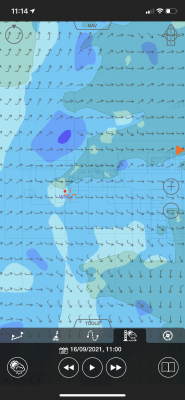
With our interactive boat route planner, you can plan your sailing trip down to the smallest detail. Our route planner tool allows you to choose your starting point and draw your desired sailing route. Once you're finished, the distance will be automatically calculated, and you can choose to have the sailing route sent to your email. Additionally, the boat route planner displays the coordinates of your starting and finishing points, so you can always know your exact location using your onboard instruments. Our boat route planner is the perfect tool to ensure the safety of your sailing trip.
Click on the video on the right and see an example of how to plan your own sailing route.

Don't lose your route , receive it on your e-mail.
Are you sure?
We use cookies to provide you with the best service on our website. If you stay on our website, you consent to our Cookies Policy .
Tell us about your dream holiday, and we'll make sure you get a personalised offer at the best price on the market.
Thank you for your message. We will get back to you as soon as possible.
We're looking forward to learn more about your dream holiday. The more info you send us, the more detailed and personalized offer we can provide.
You have succesfully submitted the details of your sailing trip. Your detailed and personalized offer is on its way.
Contact us to get some suggestions!
Thank you for your email. We will get back to you asap!
The Sailing App - It's like Google Maps for Boats.
Savvy routing, departure planning, charts, weather, wind, GPS, satellite mode and more...

Over 1 Million Downloads

4.7 out of 5 Over 5,000 5 Star Reviews

RAD NAV APP
I use Savvy Navvy daily for all my inshore fishing here in south Texas. Great for current conditions, including tides and wind direction. It’s like Google maps for boaters. Plan routes, mark your fishing spots and return to the dock in one piece. Every time! Great App 5 stars.
2 weeks ago during the heatwave, we were on the Solent and the temperature fried all our instruments including the GPS plotter. Thank god we had Savvy Navvy as it worked perfectly for the entire weekend and allowed us to do everything we wanted. People say these kind of apps aren’t meant to replace the instruments on board, well I can confirm that when they instruments on board all fail, this was an absolute lifesaver. Can’t wait to test it in other countries.
Great and simple to use
I sail with friends and families and this app is a great way to illustrate “dads” boring chart work through a much more teenage friendly platform. I use both for cross reference and find it pretty accurate. Considering the price of charts it is extremely good value.
Innovative Features To Put the Wind in Your Sails
Savvy charts™.
Whether you call them charts or a sailing sea map we don’t mind! Either way, our designers have built savvy Charts™ to show you essential marine information that’s easy to understand, without the clutter. View our chart coverage .

Sailing Route Planner
Passage planning is time-consuming but with savvy navvy you can plot a route to sail in seconds on any device, a great cross-check for traditional navigation. Tap the screen to drop a pin at your start and finish locations and the app will calculate the best route to sail, taking into account essential marine information and your boat settings.
Estimated Arrival Times
No one likes to be late but when it comes to sailing it can be tricky to be accurate when it comes to your arrival. With savvy navvy we do all the work for you. Plot a route to get an automatically predicted ETA based on wind, weather, tide and chart data. Click to share the route with your friends and family so they know you’re safe.

Tidal Streams and Tide Data
Understanding what the tide is doing is essential for sailors. That’s why we provide tidal stream data from thousand of tidal stations around the globe, in addition, sailors can use our tidal graph to easily view tidal highs and lows throughout the day. Checking the tide has never been so fun!
Global Positioning System (GPS)
Sometimes in home waters that you know well you just want to go sailing without plotting a route, we get it. That’s why savvy navvy has a “GPS view” which enables you to check your COG and SOG and easily calculate distances to key landmarks around you with ease.

Wind Forecast Map
Instead of using a dedicated marine weather app, you can now check the predicted wind direction and strength in the savvy navvy app. By using the slider you can easily view the changing wind pattern throughout the day. Read more savvy weather models
Sailing Weather Forecast
You may be used to using a dedicated marine weather app but with savvy navvy you can check the weather forecast for your location by dropping a pin on the chart to instantly view the weather forecast, wind speed and direction for that area. Use the toggle to see the changing effects of the weather over the next few days.

Fuel Efficiency
Adjust your engine and cruising speed settings to enable savvy navvy to calculate your estimated fuel consumption. Never worry about running out of fuel again.
Schedule departure time
See at a glance the best time to depart based on your route, wind & tidal conditions, see the demo .

Explore even more cool features
Automate your course to steer.
Get an automatic CTS and preview your route when planning a sailing trip with savvy routing™. Our routing algorithm uses wind, weather and tide data to give you a proper passage plan with Course to Steer information.
Marinas and Anchorages
Need to know the minimum depth of a marina? Looking for moorings or water fill-up stations? Perhaps you need to know the holding for dropping anchor? Find out all you need to know for the perfect stopover with our Navily and Dockwa marina and anchorage information, available to all members.
Satellite view
Used to using Google Maps to inspect key locations for your sailing trip? Now you can do it in the savvy navvy app! Just switch from Map to Satellite mode to take a closer look! We also have a night mode too.
Going Off-Grid - Offline Charts
Planning to sail out of range of signal? Download savvy charts™ and weather when sailing offshore so you can keep using all the app features whilst you’re away.
Exporting Your Route
You can use your savvy passage plan by exporting the route to a GPX file that can then be uploaded to your boat chartplotter.
savvy navvy is run by sailors for sailors. Think of us as your silent first mate, if you need us we’re here to help! Contact our team via the chatbot in the app or email us at [email protected]
Why are we the best sailing navigation app?
Watch our demonstration video to find out.

Marine Chart Coverage
We believe in the flexibility to sail wherever you want, so we don’t restrict you by chart locations. We provide members with access to all charts, wherever we have coverage. Take a look to view our full list of coverage.
Our range of Marine Partners

Ready to Go Sailing? Sail Away With Us, Download savvy navvy Today.
The savvy navvy boating app is available on Android or iOS with a 14-day free trial.
iOS & iPadOS.
Download savvy navvy, to start your free trial.

- Yachting World
- Digital Edition

Best navigation apps: 6 top options tested
- November 16, 2021
There are many app options on the market for sailors wishing to navigate from a smartphone of tablet. Bruce Jacobs looks at some of the best navigation apps on the market.

It’s increasingly rare these days to see any sailor without at least one navigation application on their phone, while tablets are even preferred to fixed multifunction displays (MFDs) on an increasing number of yachts. It’s great to have this navigation information so easily to hand and so mobile, but which are the best navigation apps for sailors and how do they compare.
Sailors need slightly different information to motorboaters. It’s nice to know if it’s going to be sunny, but we care more about whether the tide will be foul or fair. We need to know what the wind direction will be and whether it’s going to be an angle we can use, over and above nearby places of interest.
We looked at the most popular navigation apps, particularly from a sailor’s perspective, and highlighted what we think works well for yachting and what is best left to the motorboaters.
The absolute number one benefit of an app is the ability to instantly see where you are, on up-to-date charts, without the cost and immobility of an MFD. Every app we tested has that core functionality and, ultimately, you will get good basic use out of any of them.
Thereafter, to my mind, most of these apps have been developed with the leisure powerboater in mind. They are focused on short day trips under engine or maybe going fishing to fairly well known areas. Wind, tide and current have little impact in these scenarios beyond whether it is sunny or the anchorage is accessible.
Fast and reliable
Having spoken to a range of sailors, it’s clear that the universal requirement is for an app that delivers fast, reliable data within an intuitive interface. We want charts that show sensible levels of detail as we zoom in and out and, critically, will warn us when we need to zoom in more to see dangers that might have been hidden by vector charts.
We then want all the other essential information such as wind and current instantly accessible and able to be overlaid on the chart, and we want to be able to quickly measure distance and bearing to a relevant point.
But despite some decent contenders, the truth is that not one app delivers it all. Adding in extras such as AIS, boat data, autorouting and more is great, but that foundation level functionality should come first.
Savvy Navvy, the newcomer to the world of navigation apps, shows what the modern app could be. It is possibly the only app built with yacht sailors at the forefront and gives easily accessible wind, current and tide overlays to sensibly detailed charts. Its routing algorithm was the only app we tested that accounted for current, and its passage plans mapped out beautifully informative courses to steer.
It also recognises hazards such as tidal races and Traffic Separation Schemes (TSS). But its algorithm is too ambitious in the level of detail it tries to extrapolate from GRIB files and the app took us into dangerous shallows and routed us metres off hazards and lee shores in strong winds.
The app is nearly the absolute game changer it should be – but its programming sophistication has outstripped its seamanship and that’s an issue.
The other apps proved a mix in how suitable they are for sailors. Basic features such as wind and current were not universally available. Also often lacking were tools such as those measuring distance and bearing.
Frustrating menus
I found some of the routing software frustrating as I was made to go through multiple menus to load and select waypoints, rather than just touch two points on the screen. And some of the apps appear to have had data sources and functionality added over time, without the redesign they might then need to bring it all into one easy-to-use interface.
AIS data is a nice new feature, but some apps rely on an internet signal for it – others can link by wifi to your AIS device. Knowing how often internet signal drops on a yacht even close to land, I’m not sure I’d trust the type that doesn’t connect to the onboard AIS.
Crowd sourced data is also an increasingly common addition to the charts. Some love it for adding real time accuracy, but others claim it can be dangerously inaccurate. I suspect both are true so, as with everything, the prudent skipper should treat all information with a healthy dose of caution.
For the best mix of functionality, breadth of data and reliable information, Navionics + remains my app of choice. But if ( and it’s a big if) Savvy Navvy becomes more savvy with its seamanship – it will have everything it needs to revolutionise the sector and become the sailor’s app of choice.
Best Navigation apps for sailors:

C-Map on an iPhone
C-MAP produces my favourite charts, with just the right amount of detail for spot depths, enlarged navigational marks on land and sea and clever colouring. Wind data via GRIB files is easily overlaid and the colour shading system both makes it easy to see predicted wind speeds and discourages the user from trying to extrapolate unrealistic detail.
However, there is no tide and current overlay, which is a frustration for sailors, and it is also a disappointment that there is no satellite imagery overlay. C-MAP’s automatic routing system is fairly easy and intuitive to use but having allowed me to set a minimum depth of 3m, it would then suggest routes that contravened this limit, albeit giving a second option that didn’t. Some caution is therefore required.
Get C-Map app from the Apple App Store Get C-Map app from the Google Play Store
Note: We may earn a commission when you buy through links on our site, at no extra cost to you. This doesn’t affect our editorial independence.
Read our full C-Map navigation app review

Navionics app on a phone
Navionics Boating app
This app is intuitive and easy to use. Charts are quick to render and auto zooming of detail is probably best in class. Text is used to good effect and tells you when you need to zoom in to get more information about hazards (one of the dangers of vector charts). Arrows showing current are animated to show strength, direction and whether the tide is on the ebb or flood. Frustratingly, you have to access a different window to get GRIB/wind data, when it should surely just be an option on screen.
The Navionics Sonar option allows charts to be adapted to show depths based on real time user data from thousands of vessels, but the company sensibly warns that many other factors (such as barometric pressure) will have a considerable affect on depths.
Get Navionics+ app from the Apple App Store Get Navionics+ app from the Google Play Store
Read our full Navionics + navigation app review

Savvy Navvy app on desktop or tablet
Savvy Navvy
Savvy Navvy is a sophisticated app with all the key information ready to be switched on or off at your fingertips. It is the only app that has a routing algorithm that has inputs for wind and current (although bizarrely not leeway) and then plots a beautifully drawn course to steer. It is useful to be able to enter later or earlier departure times and see the impact on wind and tide.
Charts are a little light on detail for my liking – my sense being that artistic merit has slightly usurped navigational utility. A bigger issue with Savvy Navvy is that the sophistication of the programming for its route planning has not been matched by that of the seamanship. It extrapolates impossibly detailed wind patterns from the GRIB data and uses performance polars that cannot be adjusted – both of which make the plans interesting to look at but of little practical use.
Get Savvy Navvy app from the Apple App Store Get Savvy Navvy app from the Google Play Store
Read our full Savvy Navvy navigation app review

Seapilot app on a phone
This app is based on some features of the professional ECDIS charting systems and in many ways has some of the best features – but while some will not agree, personally I found it unintuitive to use.
The significant issue, however, is that the autozoom on its charting detail just doesn’t work in many regions. Until I zoomed in to a small area (maybe five square miles) there was so much clutter on the screen that there was not much that could be done. Even when zoomed in, information about navigational marks would often be overlaid on spot depths, making both impossible to read. Seapilot acknowledges that some regions suffer from this as an issue due to the use of ECDIS data and hopes to rectify it going forward.
The app also uses ECDIS warning symbols for some hazards, which leisure sailors won’t be familiar with.
Get Seapilot app from the Apple App Store Get Seapilot app from the Google Play Store
Read our full Seapilot navigation app review
isailor featues nice wind colouring
iSailor is another app that works well as an extension to your boat’s onboard systems. It will connect to the NMEA system and internet AIS, although each feature you unlock costs money. The alarms menu is comprehensive, including anchor drag, waypoint proximity, loss of GPS signal and a low battery warning.
Charts were fairly good, but as with Seapilot, I had issues with the auto detail of the chart at various zoom levels and had data overlaid on each other. I also found that at certain levels of zoom, key data such as spot depth was removed, but too soon for my liking. If I want to plan 2-3 miles ahead I want to see clear depth data, not just coloured contours.
Get iSailor app from the Apple App Store Get iSailor app from the Google Play Store
Read our full iSailor navigation app review

iNavx on a phone
iNavX can be frustrating to use at first because there is so much to customise that it can be tough to get into. Persevere, however, and you’ll find a good app. It has a range of chart options including Navionics, C-MAP and NOAA. They partner with Waterway Guides, which gives micro level detail for marinas and other facilities, although the UK version is yet to arrive.
While all the information is there, I didn’t find interrogation of chart data as easy as, say, the Navionics app, but this may just be personal preference. I also found building and adjusting routes frustrating. There is a very comprehensive manual that can be accessed and a range of excellent YouTube instructional videos – but honestly, I’d rather just be able to work it out quickly and easily on the app.
Get iNavx app from the Apple App Store Get iNavx app from the Google Play Store
Read our full iNavx navigation app review
If you enjoyed this….
Yachting World is the world’s leading magazine for bluewater cruisers and offshore sailors. Every month we have inspirational adventures and practical features to help you realise your sailing dreams. Build your knowledge with a subscription delivered to your door. See our latest offers and save at least 30% off the cover price.
- Easy Search
- Advanced Search
- Special Offers
- Yacht Charter Statistics Charts
- How to send a Charter inquiry?
- Booking procedure
- Charter terms
- Yacht takeover
- Skipper's licenses for yacht charter
- Standard boat equipment
- 7 Days Boat Charter
- Early booking
- Last minute Charter
- Sailing Yachts
- Motor Yachts
- Sailing route planner

With our easy-to-use route planner - plan your own trip!
Share this article with your friends
Leave a Comment
Have a Question?
- Affiliate Partners
- Extra Discounts
- Photo Gallery
- Itineraries
- Boat models in charter

- How to plan your sailing route properly
How do you plan a sailing route to get the most out of your voyage? Let’s take a look at all the factors to consider when choosing a route. Follow our guidelines and you’ll be rewarded with a perfect boating holiday that the whole crew will remember for years to come.
Before you begin planning the route
The choice of destination is crucial to a successful voyage. That’s how you determine all the options available to you when planning the route. A sailors ’s initial step should therefore be to research the destinations with regard to the experience of the crew, the weather and the voyage dates .
If you don't do this, you could easily end up heading to Italy in August , when the whole country is on vacation and spending the trip packed like sardines. Likewise, in the Aegean the Meltemi winds blow during July and August , which could turn your sailing vacation into a bit of a nightmare.
YACHTING.COM TIP: If you're not a seasoned sea dog yet, try sailing in an area where conditions are beginner-friendly. We recommend the first route in our article — Where to sail in Croatia: find the best sailing route for you or the southern or northern Ionian Sea in Greece .

Follow these 10 yachting commandments before booking your boat
Before booking your boat , it’s good to ask yourself some questions and choose the destination and route accordingly. This ensures you take away with you only wonderful shared memories and plans of where to go next.
1. What are the expectations of each crew member?
If you want an active, adrenaline-fuelled sailing holiday, you’ll be fired up by a different destination to someone planning a relaxing cruise with a group of friends.

Is it a diverse crew? It's conceivable that you'll have adventurers on board who want to sail from morning to night with the motto "the bigger the wind and waves, the better," as well as those who wish to bathe in deserted bays, snorkel, hunt for shells, and spend evenings at anchor far from civilization. Maybe you’ll even have friends who just want to spend all day moored in harbours, going to restaurants, bars and discos.
In these cases it's obviously very difficult to reconcile everyone’s expectations. The ideal solution is to meet up before you book the boat and try to reach a compromise which will appeal to everyone, no matter how impossible it seems.
2. What yachting infrastructure and sailing conditions do I need?
An experienced sailor will prefer a place with more challenging conditions and a strong wind, but they won't mind bad weather or insufficient infrastructure. Beginners appreciate an abundance of safe harbours, high-quality services, and predictable weather.
That’s why you should also research the yachting infrastructure when making your choice. If you’re used to Croatia ’s extensive network of moorings and harbours, then you might be caught off guard in Greece . Look up potential anchorages en route and plan your voyage around them (such as choosing an island with a mooring sheltered from various sides ).

3. What do you want to experience during the voyage?
Do you want to fully immerse yourself in sailing or do you want to combine it with other activities? Diving enthusiasts will be enamoured with a location teeming with life beneath the waves, others will be charmed by places jam-packed with historical monuments or captivating natural scenery. Choose your ideal location according to the interests and needs of the crew , so there’s something for everyone.

4. How many nautical miles do we want to cover?
You can sail 80 or 400 NM in a week. The first promises comfortable, relaxing sailing of two hours a day. For the rest of the day you can have your fill of swimming, snorkelling, romance and rest.
The longer distance would require 10 hours of sailing a day , long crossings motoring or under the sails. You’ll likely experience some great yachting, see plenty of places and have many experiences, unfortunately including seasickness and struggling to sleep at night on choppy seas. In a fore cabin, it can be as difficult as trying to fall asleep in a washing machine .

During the planning, you might bump heads with yachting beginners. When they look at the map, they imagine that in one week they’ll cover all the Croatian islands from north to south and back again. It’s good to remind them that novice sailors must listen to their captain, who has a clear idea of what can be achieved in a week. A little explanation can help. Average sailing speed is 5 to 7 kn (depending on the size of the sails), which is 9 to 13 km/h. It’s 340 NM from Dubrovnik to Biograd and back, which is approximately 70 hours of motor sailing time (6 days of almost 12 hours’ sailing every day). Probably nobody’s idea of fun.
Check out popular sailing destinations:
Sailing the Maldives: paradise
Croatia in autumn? A definite yes!
Top marinas in Montenegro
Sail to the 7 most beautiful sights in Greece
From Lefkada or Corfu to Paxos and Antipaxos
Discover the paradise of Paxos and Antipaxoss
Discover Corfu: sailing adventure in the Ionian
5 best sailing routes in the Bahamas
Yachting guide to the Bahamas
YACHTING.COM TIP: D uring the preparation and planning you can use the hugely popular Navionics boat navigation app. For other handy yachting apps are that are well worth downloading, take a look at our 10 best smartphone apps for sailors .
5. Will you be sailing with kids?
Families with children value stable weather and calm, warm sea and deserted, sandy bays accessible only by sea. Choose the route so that you can have adequate stops along the way. Daily sailing trips should be kept short, so the kids don’t get bored . Sailing in calm weather is ideal so mums don’t have to worry about the kids’ safety.
Children appreciate activities off the boat as well. Choose a location where kids will be able to explore islands, deserted fortresses and lighthouses, cool down with an ice cream or have fun with their water toys. If the kids are older, it’s important to find interesting places for snorkelling and exploring . See also our kid-friendly sailing itinerary .
YACHTING.COM TIP: If you are sailing with children, do not forget the main principles of safe sailing. Choose appropriate safety features, adjust the route and choose the boat with the whole family in mind. You can find out how in our article: Sailing with kids: how to keep all of you safe and happy .

6. When are you sailing? What will the weather conditions be like?
Choose your destination according to the dates you're going to ensure your safety at sea . If you choose well, it can take your sailing holiday to a whole new level and save yourself a lot of worry. Consider the expected weather and wind conditions carefully when making your choice.
- Is it high season in your chosen destination? Be prepared for crowded marinas and higher prices. However, in the autumn you can sail for cheaper and will be able to see more. Take a look at our article on 5 reasons to set sail in autumn . And if you want to find out which autumn sailing destinations to choose for pleasant weather and favourable winds, check out — Autumn sailing: top destinations, rental boats and tips .
- Are there commonly unfavourable winds on your chosen dates in your preferred destination? If so, it would be better to select another date, especially if you’re relatively inexperienced.
- Are you travelling with children ? Do you love to swim? Be sure to research air and water temperature as well.
- Do you like exploring inland and want to experience some real sailing ? Set off in spring. Outside of peak season, you’ll enjoy great sailing and lower prices.

7. What size boat do I want and what is its draught?
Choose the places you want to visit with the size and draught of the boat in mind . If you love small fishing harbours, then you won’t get into this kind of harbour with a catamaran or 57-foot boat. Even a racing boat with a 2.7-metre draught might not be the right choice. This mainly concerns old harbours in Greece, Spain, France, Turkey and Italy .

What else is worth thinking about when planning your sailing route?
8. sailing off the beaten track.
In every sailing region, there are standard routes that most boats follow, taking in the most interesting and beautiful places. When you do these routes you’ll be enthralled, but in high season there’ll be boats everywhere, loads of people, full harbours and moorings and busy restaurants.
If you head off the beaten sailing path , you’ll have a chance of uncovering small bays with neither people nor boats even in high season. It’s unlikely that you’ll ever be completely alone, but it will still be a big difference compared to the main yachting ‘draws’.
9. Location accessibility
A deserted paradise on earth where you can moor the yacht of your dreams will remain just a dream if you can’t fly there or get there by car.
10. Validity of captain’s licence
It’s the exclusive right of every country to decide whether it wants to accept a licence. Charter companies often decide on the basis of experience and habit. You should therefore also check whether your licence is valid in your chosen country or contact us. If you don't have a licence already, check out our comparison of international certifications . You can even take the prestigious RYA sailing course with us .

Don’t be afraid to change route and improvise
Don’t set the route in stone, so you can leave room to improvise and be flexible depending on the weather. It’s also good to factor in some extra time and a "lazy day".
Route planning does not end with setting sail . At sea, you always have to adapt to the weather and wind direction. If your planned route does not work with the weather forecast, just change it .
It doesn’t make sense to fight against strong winds for hours, when half the crew are seasick and when you could use the tailwind to sail comfortably to another beautiful spot. In short, wind direction is the most important deciding factor in regard to the route.

For example, you’re planning to sail south from Šibenik to Hvar and Vis. However, a strong Jugo is forecast for the first half of the week followed by a weaker Bora . If you keep to the original plan, you’ll be struggling against strong winds and waves in the first half of the week and again in the second half. The crew — unless they’re a bunch of yachting "freaks" — will definitely not thank you. However, if you change plans and sail in the direction of Kornati and Dugi Otok, then you’ll sail on a tailwind the first half of the week and your change of tack will be swift and comfortable. In the second half of the week when the wind reverses direction, you’ll be sailing back again comfortably downwind. The crew will be happy, especially when they hear stories from other crews who didn’t change course.
Are you in the planning stages and need advice? We’re happy to help you choose a destination and route , so that it fulfills all of your requirements and expectations. We will even help you pick the most suitable boat . With many years of yachting experience, we know the best spots with all their beauty and challenges.
Which boat are you taking to your dream destination?
We've got the route, let's pick a boat get in contact..

Denisa Nguyenová

Plan the perfect route

COVID 19: You can change your booking on most of our boats if your travel plans are affected by coronavirus. See here for more details
Let us help you plan the perfect sailing trip
Provide your travel details, receive free offer and enjoy your holiday!
A sailing vacation can be one of the most rewarding and fulfilling experiences of your life. However, those considering heading out to sea, especially for the first time, should not take it lightly as it can be pretty challenging.
Before you venture into this unforgettable adventure, there are eight critical elements to consider in order to create and enjoy the ideal sailing trip.
1. Before you set sail
Organising a sailing holiday can be quite a bit more challenging than your ordinary summer holiday. There are many elements to consider, so any essential sailing tips and advice should be welcomed with open arms. However, if done correctly, a sailing holiday will become your best holiday decision yet!
In this modern era, information about almost everything is just a click of a mouse away. So why not use a boat route planner to prepare for everything you will need for a sailing adventure.
With all the technological advantages at your disposal, preparing for a sailing adventure nowadays can be easy and quick.
Some user-friendly apps can be handy and make your everyday life on board much more effortless. You just need to know where to look on the internet!

Useful Apps
Google maps & google earth.
Google will be your first and primary assistant when organising your perfect sailing trip.
Using their easy-to-navigate map system is one of the best ways to get basic information about your current location.
Given that it is free and accessible with almost any smartphone, it is the most helpful tool to have.
Tip: Make sure to download the maps of the area you will be visiting beforehand to navigate even when there is no internet access.
MarineTraffic
Marine Traffic is extremely useful to use when navigating places with lots of naval traffic. The app uses the signal from your phone to find AIS (Automatic Identification System) information in your area. This system is used to supplement radar information to ensure collision avoidance.
This provides you with much-needed information about surrounding ships, especially if there is heavy fog or other adverse weather conditions. It can also be beneficial in high traffic areas like the Corinth Canal in Greece .
The app has a free version, where the essential information is available, and several paid options with more features.
PredictWind
To make sure there are no nasty surprises while at sea, a dedicated weather app is essential.
PredictWind has a user-friendly interface where you can input your chosen route and find out what predicted weather conditions await you on your way.
The app pulls information from various sources, which can be changed in the settings, depending on your preference towards the US or the European weather models.
2. Starting point

Firstly, you need to decide what part of this beautiful planet you wish to explore. Knowing where to sail and at which time of year to do it is crucial to your overall experience. Some places are best avoided at certain times of the year due to either bad weather conditions, local restrictions or high season crowds. Also, be sure to check for national and religious holidays in the period of your choice, as they often restrict the working hours of local businesses.
The best way to determine which destination to pick for your sailing vacation is by answering these questions for yourself:
- Where do I want to go?
If you have decided to go on a sailing holiday but are not quite sure which country to visit, there are plenty of options to choose from. Make sure to explore your options and choose a destination that will suit you perfectly.
Our guide on the most popular sailing destinations in the Mediterranean should help you make the final decision.
- When do I want to go on my sailing trip?
Although summer seems like the most obvious choice, sailing can be enjoyed for most of the year, depending on your preferences and location.
If you are looking to have your sailing trip in Europe, the sailing season starts around mid-spring and can last until the end of October.
Some locations like the Canary Islands , which enjoy a subtropical climate, are suited for sailing even in the middle of winter.
- What is my budget?
Sailing vacations can get expensive quite quickly. Therefore, it is essential to stay ahead of your finances and calculate all of your known expenses to avoid surprises.
Some destinations in Croatia and Turkey are better suited for smaller budgets while sailing trendy destinations like Santorini in Greece or Costa Smeralda on Sardinia can get quite expensive.
However, the most important thing to consider is the type of boat you will be chartering as the prices can vary massively.
3. Sailing experience

Unless you hire a professional crew, sailing is a very active and hands-on holiday experience. Plan your sailing route following the people that will be with you. It is not the same if you are sailing with a group of friends or taking your family and small children. There should be at least one person with some previous sailing experience. When at sea, mistakes can quickly happen and can be costly. Consider who will be coming on board with you and consider hiring a local skipper. Doing so will help navigate local areas and find the best-hidden spots to anchor, making the journey much more enjoyable.
If you wish to be fully prepared for your sailing trip, these are the basic steps you should consider:
- Familiarise yourself with the basic nautical terminology
- Learn about the different parts of a boat
- Practice some fundamental sailing knots
4. Logistical requirements
Familiarise yourself with the infrastructure of the areas you will be visiting. Knowledge of local marinas, ports and anchorages will save you from unnecessary stress. Some countries offer better sailing infrastructure than others which can mean all the difference when sailing, especially for those less experienced. Also, be sure to have your license sorted out, as you could be facing fines if stopped by the local authorities without having proper documentation.
- Most of the more significant marinas in the Mediterranean have their own websites where you can find the most recent information and check vacancies.
- For information on smaller harbours and ports, check the website of the town or region you are visiting. The local tourist information centre should have all the information you’ll need.
5. Holiday intensity

When planning your sailing route, consider the distance you are willing to travel during the trip. Make use of one of many sailing distance calculators and boat route planners available online, primarily the one integrated within Google maps. There is a big difference between sailing 100 nautical miles or sailing 300 nautical miles in a week. It is also dependent on the type of vessel you will be chartering. Some boats are better suited for longer distances than others. Motorboats are also less dependent on weather conditions and winds than sailboats and catamarans . Finally, keep in mind that stopping at each marina or port requires time and preparation.
Additionally, the size and experience of your crew will be detrimental to the nature of your sailing trip. The more experienced people there are on deck, the chance of any nasty surprises decreases.
Always be mindful of the weakest swimmers on board and make sure they either wear their life jackets or have quick access to them.
6. Be flexible

Keep in mind the unpredictability of weather and be prepared to adapt accordingly. Unlike holidaying at a resort or hotel, sailing holidays are heavily dependent on weather conditions. As a result, sail routes and itineraries can become obsolete if you are forced to remain anchored for a day or two due to bad weather.
Familiarise yourself with the area you’re visiting, and be prepared to improvise and adjust if needed. Make sure to check the weather conditions at least three times a day.
In case of an approaching storm when at sea, remain calm and organise your duties efficiently.
Hiring a local skipper can help you massively if caught in bad weather and provide you with alternative destinations and activities if the circumstances change.
Nothing is set in stone when you venture out to sea, so thinking on your feet and being flexible is of utmost importance.
7. Be adventurous

Sailing along popular routes and visiting popular tourist destinations often means dealing with high sea traffic and big crowds of tourists. This can lead to congestion in marinas, especially in smaller towns scattered around the Adriatic and the Mediterranean. However, if you decide to be a bit more adventurous and head off the beaten sailing path, you’ll have a chance of uncovering small coves and bays with a bit more privacy and space.
Sailing is one of the best ways to immerse yourself in your surroundings and embrace the customs and traditions of the country you are visiting.
Sometimes it is better to avoid the top tourist destinations and try exploring places off the beaten path. All Mediterranean countries are full of charming coastal villages and secluded harbours , just waiting to be explored.
Destinations like Croatia and Greece have an abundance of small islands where one can get lost and easily find a secluded cove just for themselves.
If you have a skipper with you, they will be more than happy to take you to some of their favourite spots in the area.
8. Plan your days

Even though sailing can be overwhelming, especially for beginners, it can also be the most fulfilling holiday you will ever take. It is essential to plan your days: for example, who will be in charge of what duties, where you will spend the night and what activities will be on the agenda that day. There is something truly magical about spending a week on the sea. Your morning coffee or tea will taste better. Meals made onboard will feel like a unique culinary experience, while swimming and snorkelling away from the crowded beaches will make you wish you could spend every summer holiday on a boat.
Checklist before you set sail:
- Make sure you have just enough provisions - enough food and water for a couple of days at least
- Check that all of the onboard equipment works - including the radio, stove, toilet, etc.
- Pack proper clothing and nothing more - space is limited, so make sure to pack only the necessary things (and don’t forget something in case of bad weather)
- Stock up on medical supplies - make sure to have a robust first aid kit which will come in handy in case of an accident far away from any hospital
- Bring some entertainment - books, board games, and playing cards are ideal for relaxing after a long day at sea
Map Your Route Yacht distance calculator
Map your route.
You can plan your sailing journey down to the last detail with our interactive distance calculator. Select points on the map below to plot your route. Enter the speed, fuel consumption, and fuel cost to determine the total cost of the trip.
Carbon Offsetting:
Total distance.
0 Nautical Miles
0 Kilometers
0 Fuel Consumed (litres/hour)
0 Total Cost
Explore the world of chartering
Your perfect adventure awaits on a luxury charter yacht. Whether you are new to the world of yacht charters or a seasoned pro, our yacht consultants are here to help at every stage of your yachting journey.

Luxury Yacht Charters with TJB Super Yachts: Uncover Remarkable Experiences.

How to Charter A Superyacht
Explore the thrills of chartering a superyacht with TJB Super Yachts. Learn how to charter a yacht and discover the TJB Super Yachts difference here.

- Concierge Services
Welcome to the world of bespoke luxury lifestyle: yacht concierge services powered by TJB Super Yachts.
CONTACT OUR TEAM
Interested request a call-back.
By filling out this form you will receive communications on our services and offers. You can unsubscribe at any point in the future from our mailing list using the ‘unsubscribe’ link on any of our emails. In order to understand how we use and protect your personal information, please read our privacy policy .
Share this page
- All Superyachts for Sale
- Motor Superyachts
- Sailing Superyachts
- Buying A Superyacht
- Selling a Superyacht
- Buying a Yacht FAQs
- Selling a Yacht FAQs
- Why choose us?
- Building a Custom Superyacht
- Build a Semi-Custom Superyacht
- Yacht Management
- Yacht Marketing
- All Superyachts for Charter
- How To Charter A Yacht FAQS
- Design Your Perfect Itinerary
- Mediterranean
- Indian Ocean & Asia
- South Pacific
- The Rest of the World
- Where Can I Travel?
- Summer Experiences
- Winter Experiences
- Wellness and Fitness
- Parties and Event Planning
- Adventures and Experiential Travels
- Yacht and Boat Shows
- Sporting Events
- Corporate Events
- Social & Luxury Events
- Sailing Regattas
- Charter Itinerary Builder
- Distance Calculator
- In the press
- Superyacht Charter Fast Facts
- Superyacht Sales Fast Facts
- Meet Our Team
- Our Offices
- Current Role
Privacy Overview
Forgot your password?
Enter the email address linked with your account and we'll send you a secure link to change your password.
Booking Advisor Form
Fill in the form below and you will soon receive suggestions with the ideal yachts for your trip.
Sleeping guests
Cruising guests
Your form has been submitted successfully!
A travel expert will contact you shortly to suggest the ideal yachts for your trip.
- Booking Advisor
Let a travel expert suggest the ideal yachts for your trip.
Enter the 4-digit confirmation code below:
Code hasn't arrived?
You can retry in .
The code you entered is incorrect. Please try again.
Your email address has not been confirmed yet. Please check your inbox and click on the link that has been sent to you.
- Help Center
- Terms of Service
- Privacy Policy
- Rent a Boat in Greece
- Deciding to list
- Add listing
- About Listing
- Sailing Distance Calculator
Introduction
What is fastseas, how do you use it, get routing and departure planning results while offshore, via email (iridium go, sailmail, winlink, etc.), via satellite communicator (garmin inreach, zoleo, spot, bivy stick, etc.), command reference.
FastSeas is a weather routing and passage planning tool. It will calculate the fastest route to take you from point A to point B given the current NOAA GFS weather forecast , current oceanic currents , the performance of your vessel, and your comfort criteria .
Feel free to look around, but before you can actually run routing calculations, you'll need to log in . Logging in allows FastSeas to remember your polar and comfort criteria. You can log in using various social login options. I have taken this approach rather than having you register with a username and password because it's less work for me and safer for you - as I don't have to deal with passwords. There is nothing nefarious going on here. FastSeas is not going to be reading your posts or creating posts or any such thing.
Configure Your Vessel's Performance
You need to teach FastSeas about the performance of your vessel. You do that using the Vessel Performance tab. You only have to setup these performance settings once. FastSeas will save these settings and use them next time you come back. There are instructions on the Vessel Performance tab, so I won't repeat them here. The amount of data you have to enter on the Vessel Performance tab can look intimidating, but it goes pretty quickly.
Set Start & Finish Locations
Before FastSeas can calculate a route, you need to tell it where you are starting from and what your destination is. You do that using the Routing tab. On the Routing tab, you'll see a map with an "S" marker and a "F" marker. These represent your start and finish points. They can be positioned by dragging them on the map. Or if you prefer, you can enter the Lat & Long into the fields.
You can now run weather routing calculations by clicking the Calculate Route button on the Routing tab. After the calculation is complete, the route will be displayed on the map. You can also look at the details of the route on the Route Positions tab, and summary stats on the Passage Stats tab.
You can specify your comfort criteria on the Routing tab. You can enter the maximum wind speed in knots that you are willing to tolerate beating (forward of the beam), reaching (aft of the beam), and maximum gust conditions.
Note that you can run multiple calculations, perhaps with different departure times, comfort criteria, or destinations, and have all of these routes displayed in the same map.
You can also get routing and departure planning solutions from FastSeas via email (e.g. Iridium GO! , Sailmail , Winlink , and other email services) and via Garmin inReach and other short message satellite communicators such as Zoleo, Spot, and Bivy Stick devices. This is particularly useful when offshore or in remote anchorages - when you don't have access to high-speed internet. Results are provided by an automated email responder, which automatically calculates the route or departure planning result in response to your emailed request, and sends the result back to you in a reply email within a few seconds. Using the email responder service requires a FastSeas subscription .
Routing Requests
To request a route using the email responder service, send an email like the one below:
Where 12.0N,68.3W are the coordinates of your departure point (in decimal degrees) and 10.9N,63.8W are the coordinates of your destination. The subject is not consequential - you can make it whatever you like. You can also specify coordinates in degrees and minutes if you prefer as shown below:
Where 12-0N is 12 degrees 0 minutes North, and 68-18W is 68 degrees 18 minutes West.
A few minutes after sending your email, the automated email responder will send you a reply containing a GPX file which contains your routing solution. The GPX file contains waypoint data for your optimum route. Each waypoint contains predicted weather data for that waypoint in the waypoint description field. GPX files can be imported into a variety of chart plotters and navigation software (e.g. Navionics "Boating" app, OpenCPN, iNavX, Coastal Explorer, etc.). The GPX file is typically very small (less than 5 KB) and therefore very suitable for low bandwidth HF or satellite access.
The automated email responder will only respond to requests from authorized email addresses. That includes the email address you registered with, or to any email address you setup in the Account tab - where you can authorize your Iridium GO, SailMail, Winlink, and other email addresses.
If you prefer to get a Google Earth KMZ file instead of the standard GPX response, add a KMZ switch to your request as shown below:
If you would like to receive a compressed GPX file (zipped), then use a GPXZIP switch instead.
If you would like to limit the number of days included in the route mailed back to you, then add a DAYS=3 switch, substituting the number of days you wish to receive:
You can also receive the routing data in a table (CSV file) using the CSV switch.
The default departure time for routing request submitted via the email responder in "now." You can adjust the departure time using the optional DEPARTURE_DELAY_HOURS parameter. For example, use DEPARTURE_DELAY_HOURS=2 to set the departure time to two hours from now; or use DEPARTURE_DELAY_HOURS=24 to set the departure time to this time tomorrow (24 hours from now).
You can optionally include parameters to adjust your comfort criteria. To set the maximum wind you are willing to tolerate forward of the beam, use MAX_WIND_BEATING=20 (e.g. 20 kn). Use MAX_WIND_REACHING=30 to set the maximum wind you are willing to tolerate aft of the beam. Use MAX_WIND_GUST=50 to set the maximum wind gust you are willing to tolerate.
If you would like to disable ocean current effects in the routing calculation, add a NO_CURRENT switch to your request.
You can also optionally include parameters to adjust your polar performance and motoring criteria. To set the polar performance adjustment, use PERFORMANCE_ADJUSTMENT=90 (e.g. 90%). Use START_MOTORING=3 (e.g. 3 kn) to set the boat speed at which you will start motoring. Use MOTORING_SPEED=7 (e.g. 7 kn) to set the speed at which you motor.
Departure Planning Requests
You can also get departure planning results from FastSeas via email. To get departure planning results, send an email like the following:
The reply email will contain an attached table with your departure planning data.
The FastSeas email responder also supports Garmin inReach and other short message satellite communicators such as Zoleo, Spot, and Bivy Stick. Messages on these devices are generally limited to 160 characters of plain text - and so this imposes some limitations on what FastSeas can send.
Garmin inReach Routing Requests
InReach devices usually automatically provide your current location in messages sent from the device, so there is no need to provide your current/start position latitude and longitude when submitting routing and departure planning requests from your inReach device. If you wish to specify a departure position different from the position automatically reported by you inReach device, then you certainly may include both departure and destination positions in your request.
When sending a request from an inReach device, you must include the EMAIL parameter, specifying the email address you registered with (see the Account tab) . This is required because messages from inReach devices do not provide a reply email address.
Example routing request:
Zoleo, Spot, or Bivy Stick Routing Requests
When sending a request from Zoleo, Spot, Bivy Stick, or other short message satellite communicator device, you must include the SHORT parameter, which tells FastSeas to respond using the short message format. You must also include both the start and destination latitude and longitude.
Some devices may require reply messages to be shorter than 160 characters. For example, Spot devices have a 140 character limit. You can configure different maximum reply message length using the MSGLEN parameter as shown in the example below:
Example Routing Request Response
Response messages are limited to 160 characters, so FastSeas will by default send a single compact reply message - consisting of the next 4 positions along the optimum route at 6 hour intervals. For example:
Where (looking at the first row of data):
If you need more waypoints, you can send a request with the optional WAYPOINTS and INTERVAL parameters, where WAYPOINTS determines how many waypoints will be sent (default is 4 waypoints), and INTERVAL determines how many hours between each waypoint (default is 6 hours). For example:
The example request above will send 24 waypoints with 4 hour interval between each waypoint. If you request more data than can fit in a single 160 character message, then FastSeas will reply with multiple messages. The example request above will result in a chain of 6 messages being sent in reply.
Departure planning responses to inReach and short message devices are similarly brief. The default response will include a single day (departing today) of departure planning stats sent in a single messages. Example request:
Example response:
You can request several days of departure planning results by specifying the optional PLANS parameter in your request. The example request below requests 5 days of departure planning stats, which will result in 5 separate response messages being sent to your inReach device:
Vessel Performance
A polar diagram is a common way of depicting vessel performance in various wind conditions. The diagram plots boat speed at various true wind angles and wind speeds. The true wind angle is indicated around the edge of the semicircle. Boat speed is then plotted at various true wind speeds - different color lines representing different true wind speeds. The boat speed is indicated as the distance from the center of the circle. Concentric circles indicate boat speed starting at zero in the center of the circle and extending out at 2, 4, 6, 8, and 10 knots boat speed.
Create a Simple Polar
You can create a simple polar diagram for your vessel by providing the waterline length (LWL) and closest point of sail (this is half of what you tack through) below. Click the "Create" button and FastSeas will generate a simple polar diagram from these two data points. You can can then refine the resulting polar diagram by selecting the Edit option below.
You can create a simple polar diagram for your vessel by providing the waterline length (LWL). Click the "Create" button and FastSeas will generate a simple polar diagram from the provided LWL. You can can then refine the resulting polar diagram by selecting the Edit option below.
Edit My Polar
Edit the polar diagram for your vessel by entering boat speed values in the table below. In this table there are four columns for different true wind angles. True wind angles measure the direction of the win relevant to the bow of the vessel. A true wind angle of 0° represents wind coming directly from the bow, and 180° represents wind coming directly from the stern. Sailing vessels should enter the closest point of sail in the first column header. The table has six rows for different true wind speeds (5, 10, 15, 20, 25, 30 knots). In each cell in the table, enter your boat's speed in knots for the given true wind angle and true wind speed. The polar diagram will be automatically updated as you enter this data. Your polar will be automatically saved in your account for reuse on your next visit.
Import/Export Polar
Use this option to import a polar created elsewhere; or to create a more complex polar than is possible using the Edit option above; or to export and save your polar for safe-keeping or for re-use in some other routing application.
Paste your qtVlm , OpenCpn , or iPolar formatted polar data in the window below and click the Import button.
Route Positions
Passage stats, departure planning.
Departure planning will calculate estimated route statistics based on the departure date/time, start location, and finish location that you configure on the Routing tab. It will calculate these stats on one day departure intervals starting with the departure date you specify on the Routing tab. These stats are rough estimates and intended for comparison of potential departure dates.
Administration
User accounts.
Ok, time for some common sense...
- FastSeas will not avoid reefs or other navigational hazards. Use real charts and your eyeballs for that.
- FastSeas will not keep you safe from localized weather phenomena (squalls, waterspouts, etc.).
- FastSeas will not keep you safe from cyclones/hurricanes.
- FastSeas will not keep you safe from piracy risks.
- Every Captain is responsible for the safety of their own vessel and crew. FastSeas is no substitute.
- All data presented by FastSeas is generated by computer models subject to error and deviation from reality. Use at your own risk.
You have imported custom polar data. If you edit it here, your imported polar data will be modified and likely significantly simplified in order to fit the data entry screen.
Are you sure you want to proceed?
When switching between "Sail" and "Power", FastSeas will generate a new "Simple" polar and your existing polar will be replaced/lost.
Calculating - Please Wait...
Terms and conditions.
FastSeas offers a REST API to facilitate integration with third-party services and products. The FastSeas API supports weather routing, departure planning, and vessel polar generation requests. The API is implemented in a highly available and scalable architecture and is ready for your web-scale use cases. Please direct inquiries to Jeremy .
- Weather Routing using GFS wind forecast and ocean current Limit 5 requests per month
- Departure Planning Limit 5 requests per month
BILLED $60 ANNUALLY
$ 10 /month
BILLED MONTHLY
$ 7.50 /month
BILLED $45 EVERY 6 MONTHS
- Unlimited Weather Routing requests
- Unlimited Departure Planning requests
- Email Responder supporting Iridium GO!, Sailmail, Winlink, and Garmin inReach
Secure credit card payment
Cancel Your Subscription?
Click " Confirm " below to cancel your FastSeas subscription.
Cancellation will be effective at the end of your current billing period on .
Thank You For Subscribing
Your subscription is now active. Your subscription renewal date is .
FastSeas is a sailing passage planning tool. It will calculate the fastest route to take you from point A to point B given the current NOAA GFS weather forecast , current oceanic currents , the performance of your vessel, and your comfort criteria .
FastSeas is created by Jeremy Waters. Jeremy is a lifelong sailor with extensive cruising experience spanning the Western Mediterranean (Costa del Sol, Balearics, Algeria), Eastern Caribbean (Virgin Islands through Trinidad, Venezuela, and Bonaire), throughout The Bahamas, US The US Gulf and East coasts (Florida through Chesapeake), and a transatlantic.
If you have feedback, suggestions or questions, please email them to me.

Can't find your answer?
We're here to help. Get in touch and we'll get back to you as soon as we can.
Send us an email
What weather forecast does FastSeas use?
Does fastseas consider the affects of current in calculating the best route, when are the gfs forecasts updated.
NOAA publishes GFS model data four times a day. The approximate times that FastSeas acquires these new data are shown below:
- 05:00 - 05:15 UTC for the 00z forecast
- 11:00 - 11:15 UTC for the 06z forecast
- 17:00 - 17:15 UTC for the 12z forecast
- 23:00 - 23:15 UTC for the 18z forecast
When is OSCAR data updated?
How does fastseas calculate passages that exceed the forecast duration, welcome to fastseas weather routing.

I am hidden
It's like Google Maps for boats.
Charts, weather, tides... everything you need in one place.
Over 10,000 downloads
4.6 out of 5 stars
“When I found myself at night and in unfamiliar waters, I had one friend checking the water depth with a pole and another friend looking for a boat nav app. Luckily we found Sea Drive. We were able to navigate home and I've been a Sea Drive user ever since.”
It really is like Google Maps for boating!
Depth and soundings are accurate, works well off the coast. It's the best water nav app I found.
Simple & intuitive
Sea Drive is dead simple to use and has free chart data and offline downloads. Finally a modern boat navigation app!
Fantastic App
I use Sea Drive everyday fishing in the Long Island sound, usually around Block Island or Newport. Great for tides, winds, weather. I mark all my favorite fishing spots and use the live location sharing when my buddies are out on the water. Great app. 5 stars!
RAD NAV APP
Free US Charts
You already paid for charts with your tax dollars. Why pay twice? Sea Drive gives you unlimited access (both online and offline) to all NOAA charts.

Tides & Currents
Check tides and currents without an internet connection. Visualize tides and currents for years into the future (or past) at more than 3000 locations around the US.
GPS Location
Turn on the GPS to instantly see your location on the chart. Sea Drive supports north up, course up, and heading up view modes. Your speed over ground is always available.

Offline Downloads
We know offline support is important, that's why it free. Download unlimited offline charts so you have access anywhere anytime.
Satellite Overlays
Enable satellite overlays for better navigational awareness and to help visualize your next destination whether it's a beach or a marina.

Turn on dark mode during twilight or overnight passagemaking to improve night vision and situational awareness.
Want sweet product updates?
Android & iOS updates, product announcements, hit the subscribe.
We never share your data. Read our Privacy Policy.
And more awesome features!
Drop a pin on a secret fishing spot or any point of interest. Share or export your markers.
Build routes and customize waypoint names. Navigate and view ETA, SOG, and bearing to the next waypoint.
Record, pause, and save your vessels location. Share and replay your routes or export a GPX file.
Distance Measurements
Use the caliper tool to measure the distance between points.
GPX Exports
Export routes, tracks, and markers as a GPX file for easy sharing with friends or compatible devices.
Heading Line
Orient your chart to course up mode and view a heading line overlaid on the chart.
Information Tool
Position the cursor and wipe up on the info panel to view details about anything on the chart.
Custom Depth Shading
Tailor the depth shading for your vessel type, be it a paddleboard or a deep keel sailboat.
Safety Depth
Set a custom safety depth and Sea Drive will show warnings about shallow areas.
Location Sharing
Share a link with friends for real time track updates, great for meeting up on the water.
Weather Data
Access weather forecasts including wind and swell/wave heights.
User Driven
We love feedback (especially the bad stuff). Contact us with requests and ideas. We might even build it!
Check Chart Charts
Sea Drive provides chart coverage for the US, the Great Lakes, and US Territories. We'll expand more globally in the future and we promise to keep chart data at as low of a cost as possible.
Ready to dive in? Start using Sea Drive today.
Route planner
Plan and navigate your route with one app.
Explore the waters and easily plan the best boating trips. Plan routes before you head out and share them with friends and family. You always have an up-to-date picture of the key points and sailing messages on your journey.

Nautical objects
Bridges & locks
Average rating

Complete routes
Prepare your trip thoroughly with comprehensive itineraries between your starting point and destination
Quick and easy
Plan your route automatically or manually, before you travel or while you are already on your way
Alternate routes
Easily find and discover alternate routes to and from a specific location
What our users are saying
Very user friendly app. Functions perfectly. After entering your vessel data, it’s easy to prepare routes. I already have my routes in Friesland ready for sailing.
- ton buijs
Well-functioning route planners
I have often used this app on the water, but after the latest update with automatic route planners I am completely thrilled. Clear display of operating times and all other necessary information for water sports enthusiasts.
I use the app very regularly and sail all over the country. I think it works very well and is pleasant to work with. Satisfied!!
- Wilkin den Boer
Nautical data
Complete with water maps of 4 countries, bridges, locks, marinas and more
Current information
Opening times of marinas, bridges and locks, current sailing info, blockages and more
Sail safer with an even more complete picture of vessel traffic en route

Offline use
Download the complete water maps for offline use and avoid surprises when sailing
Regular updates
Get free access to all new functionalities with a subscription
Personal service
Customer service 7 days a week via our helpdesk
Try the first 7 days for free now
Almanack info.
Sea route & distance
find start port:
find destination port:
start typing to see the suggestions
Distance: nautical miles
time at sea
Paste link in email:
© 2010-2023 Ports.com
- USA +1 954 892 5009
- UK +44 (0)20 7193 5450
- Asia +66 6000 35434
- Crewed Yachts
- Destinations
Boatbookings Journey Planner
Calculate the distance, fuel consumption, and cost of your next boating trip.
Boatbookings have created the leading online yacht charter route planner, distance and fuel calculator, so you can see your exact cruising plan and itinerary in unrivalled detail. See how far it is between each place of interest and all the islands and towns you will pass on route. Your charter is in your hands!
All you need to do is 1 - search for your port, 2 - click "Start New Route" and click through the exact route you'll be taking. Then 3 - enter average speed and fuel consumption per hour, and everything is calculated for you! Full instructions here .
See our yachts in the British Virgin Islands | A guide to Cannes and the French Riviera | Yacht charters in Greece | Amalfi Coast Yacht Charters
- 1 - search for your port
- 2 - click through the exact route
- 3 - enter average speed and fuel consumption per hour
Top Charter Areas:

Complete directions:
Enter your embarkation point and click through the map with where you plan to go. A line will trace your route, and the distance is calculated at each click. Double click to finish. Then scroll below and enter the price of fuel, the cruising speed and consumption of your yacht - everything is calculated for you!
Here's an example of a week long Amalfi Coast crewed motor yacht itinerary , embarking in Naples, visiting Procida, Ischia, Capri, Sorrento and the Amalfi Coast, showing the route, distance, and projected cost of the cruise:

We also have a CO2 Emissions Calculator , so that you can calculate your yachting Carbon Footprint as well as buy carbon offsets. Click here to read all about low carbon yacht chartering .
Looking to rent a day boat ? See our sister site MyDayBoat.com for great prices, real time booking, and direct contact with the boat owner!
Anti spam We'd love to contact you by email about yachts, destinations and offers. Do tick this box if you are happy for us to do so.

No Obligation Travel Itinerary
Chartering Information
Charter distance and cost calculator!!
Why Charter a Yacht?
Yacht Charter Basics
Charter and Rental Pricing and Boat Affordability for 2024 and 2025
Yacht Charter Fees and Insurance
Frequently Asked Charter Questions - Yacht Charter FAQ
About Boatbookings
Why Charter With Boatbookings?
Yacht Charter Insurance
Crewed Yacht Charter Checklist
The Yacht Charter Experience - Getting the most from your boat rental
Boat Rentals Guide - how to Rent a Boat for a Charter Holiday Vacation
Yachting and Boating Glossary of Terms
Browse All Articles
Our most popular charter regions
- Caribbean Sea Charter Yachts
- Mediterranean Sea Charter Yachts
- Pacific Ocean Charter Yachts
- Thailand and Indian Ocean Charter Yachts
- Virgin Islands Yacht Charter
- Bahamas Yacht Charter
- Seychelles Yacht Charter
- Where We Charter
Several of the key worldwide chartering events of the year.
- Corporate Yacht Charter
- Event Yacht Charter
- Cannes Film Festival Yacht Charter
- Monaco Grand Prix Yacht Charter
- Charter Events in Cannes
- Weddings and Honeymoon Yacht Charters
- Family Charters with Children
- List your Charter Yacht on Boatbookings
Our International Specialized Sites
- Stunning Yachts Charter
- Boating News and Blog
- Boat Itineraries
- France location de bateaux
- Boten Verhuur, Boot Charter
- Boot Charter/Location de Bateaux
- Alquiler de Embarcaciones
- Turkiye Yat Kiralama
Rating: 4.9 / 5 calculated on 1304 reviews
- London +44 (0)20 7193 5450
- French Riviera +33 (0)9 70 46 39 79
- Ft Lauderdale +1 954 892 5009
- Thailand/Asia Pacific +66 6000 35434
General Email Contact: [email protected]
- © Copyright 2024 Boatbookings
- T's and C's
- Useful links
- Testimonials
- © Copyright 2024 Boatbookings | T's and C's | FAQ |
This website uses cookies --- I understand and accept
Sailing Distance Calculator
Find a boat, why book with us.
Competitive prices, Exceptional Service
ONLY Professional Charter Fleets
Rated 4.9/5 on Feefo
Super-low 25% deposit
It’s down to the public vote – please vote for us here! (takes 20 seconds)
We’ve been shortlisted for a British Travel Award and need a quick favour – please vote for us in the form below (it takes less than 20 seconds to complete and is an official form – they won’t send any spam) – and in return we’ll guarantee to keep this nifty Sailing Distance Calculator free-to-use for another year . Thanks for your help and support!
Our Calculator makes planning your sailing holiday a little more 'Plain Sailing'...
We're proud to unveil our Sailing Distance Calculator - helping to make passage planning for your sailing holiday so much easier! Want to find out how far it is to that little bay you've been recommended, or that must-see Taverna? The answers are right here!
How does it work?
- Click on the map to set your start point.
- Click your route to navigate around the map - it will add up the distance as you go.
- If you want to go back a step, or start again, just click the buttons below the map.
- The map can be centred around any of the below starting points - click your home base and get started! :)

TOP TIP: If you’re after a leisurely sailing holiday (doing 4-5 hours of sailing a day), we’d recommend sailing around 20-25 nM a day.
Tags: Sailing Distance Calculator
Plan a route: Sailing route
Routes » Route planner » Sailing route
JavaScript is required for this feature, but it is either disabled or not supported by your browser. Please enable JavaScript or upgrade your browser.
Try this feature for free with a RouteYou Plus trial subscription.
If you already have such an account, then log in now.
- Search for a route
- My favorites
- Best rated routes
- Most popular routes
- Node routes
- Signposted routes
- Nature routes
- Cultural routes
- Partner routes
- Create a route
- Upload a route
- Record a route
- Hiking nodes
- Cycling nodes
© 2006-2024 RouteYou - www.routeyou.com
IMAGES
COMMENTS
Additionally, the boat route planner displays the coordinates of your starting and finishing points, so you can always know your exact location using your onboard instruments. Our boat route planner is the perfect tool to ensure the safety of your sailing trip. Click on the video on the right and see an example of how to plan your own sailing ...
VAR 3.5°5'E (2015) ANNUAL DECREASE 8' Edit. Map with JOSM Remote; View. Weather; Sea Marks; Harbours; Sport; Aerial photo; Coordinate Grid
Coordinate grid. OpenSeaMap seamarks. Interactive seamarks. Official depth data for Germany/MV. POIs for scuba diving. Search places. Marine traffic. Download map bundles. Debug tiles.
Sailing Route Planner Passage planning is time-consuming but with savvy navvy you can plot a route to sail in seconds on any device, a great cross-check for traditional navigation. Tap the screen to drop a pin at your start and finish locations and the app will calculate the best route to sail, taking into account essential marine information ...
Get local and national boating conditions. Plot your course with interactive nautical charts complete with weather radar, buoy reports, wind speed, wave heights, and marine forecast.
iSailor. iSailor is another app that works well as an extension to your boat's onboard systems. It will connect to the NMEA system and internet AIS, although each feature you unlock costs money ...
To plot your route, use the controls in the left-hand corner of the map. Click on the icon, then click on your starting point and drag the mouse to your next point, click and continue. When you have finished your route, click on the "Finish" option next to the icon; or click on the last point again. You will see the total distance of the route ...
You can sail 80 or 400 NM in a week. The first promises comfortable, relaxing sailing of two hours a day. For the rest of the day you can have your fill of swimming, snorkelling, romance and rest. The longer distance would require 10 hours of sailing a day, long crossings motoring or under the sails.
Route Planner improves operational efficiency by route optimisation for any sea passage. Speed profile, ECA zone avoidance, and gateway preference help you to compare various routes.
When planning your sailing route, consider the distance you are willing to travel during the trip. Make use of one of many sailing distance calculators and boat route planners available online, primarily the one integrated within Google maps. There is a big difference between sailing 100 nautical miles or sailing 300 nautical miles in a week.
MAP YOUR ROUTE. You can plan your sailing journey down to the last detail with our interactive distance calculator. Select points on the map below to plot your route. Enter the speed, fuel consumption, and fuel cost to determine the total cost of the trip.
View suitable yachts now. Booking Advisor. Let a travel expert suggest the ideal yachts for your trip. Verify your phone number. Your phone number is required so the owner & the captain can contact you during your trip. Add new number. Send Confirmation Code. SavedRetry. Enter the 4-digit confirmation code below:
Finding the optimum route from point A to point B, using the latest GFS grib weather and ocean current data. FastSeas ... PLAN 1 DEP 16 APR 14:34Z TIME 2d4h MOTOR 0h W-MIN 11 W-MAX-BEAT 19 W-MAX-REACH - W-GUST 25 W-AVG 17 %BEAT 100 %CLS 0 %BEAM 0 %BRD 0 %RUN 0 BS-AVG 6.8. Where: ... FastSeas is a sailing passage planning tool.
Sea Drive provides chart coverage for the US, the Great Lakes, and US Territories. We'll expand more globally in the future and we promise to keep chart data at as low of a cost as possible. Ready to dive in? Start using Sea Drive today. Your personal lighthouse. Modern marine navigation. Sea Drive is a chartplotter app with free charts, tides ...
Navigation tools. Distance and route computation. Create a port, anchorage, an area
Plan and navigate your route with one app. Explore the waters and easily plan the best boating trips. Plan routes before you head out and share them with friends and family. ... After entering your vessel data, it's easy to prepare routes. I already have my routes in Friesland ready for sailing. - ton buijs. Well-functioning route planners.
2. Use Our Sailing Distance Calculator. If you're interested in planning your own route, then the next easiest thing to do is to hit the PlainSailing.com Sailing Distance Calculator - which is basically like sitting in front of a sailing chart with a pair of compasses, but way quicker and less fiddly! You can find your charter start point ...
find destination port: start typing to see the suggestions. calculate. +. Calculate sea route and distance for any 2 ports in the world.
Use your charts in SailGrib WR at no extra cost! SailGrib WR, our flagship app, includes all the features you will need to navigate: weather, tides, currents, easy to use but very powerful routing, NMEA, AIS with its alarms. You can use your Navionics charts, or purchase atlases of marine charts as in-app purchase.
Calculate the distance, fuel consumption, and cost of your next boating trip. Boatbookings have created the leading online yacht charter route planner, distance and fuel calculator, so you can see your exact cruising plan and itinerary in unrivalled detail. See how far it is between each place of interest and all the islands and towns you will ...
We've been shortlisted for a British Travel Award and need a quick favour - please vote for us in the form below (it takes less than 20 seconds to complete and is an official form - they won't send any spam) - and in return we'll guarantee to keep this nifty Sailing Distance Calculator free-to-use for another year. Thanks for your help and support!
Plan your boat route along the most beautiful tracks in English. Print, download as GPS track and save it.
Plan your sailing route along the most beautiful tracks of the United States. Print, download as GPS track and save it.