
Tour du Mont Blanc | Maps & Routes
The Tour du Mont Blanc takes trekkers through France, Italy, and Switzerland on one of the most spectacular trails in the world. Typically completed in 11 stages, the route circumnavigates Mont Blanc, the highest peak in Western Europe. This post will provide all of the TMB navigational resources you need to familiarize yourself with the route, location, and all things map-related so you can be sure you’re ready to tackle this epic adventure!
What’s in this post?
Where is the tour du mont blanc.
- Interactive Tour du Mont Blanc map
- How long is the Tour du Mont Blanc?
- What is the elevation profile of the Tour du Mont Blanc?
- Which maps should I carry?
Tour du Mont Blanc GPS/GPX
- Apps and offline mapping
- Let Us Make Your TMB Trip Success
Let us help plan your TMB
We’re here to help! We offer comprehensive TMB planning support so you can plan your perfect trip!
In addition to our popular guides, we also offer the following TMB planning services:
GPS Digital Download
GPS files for the entire TMB
Navigate with confidence on the trail
Works with all GPS navigation apps & devices
Custom GPS File
Custom GPS file created for your unique itinerary
Includes all of your accommodations
Confidently navigate using a GPS file designed just for you
Expert Consultation s
1-on-1 video calls
Specifically catered to your questions
Problem-solve your itinerary, bookings, route options, and more!
Why work with us?

As passionate hikers, we’ve made it our goal to empower you with all of the information you need to have your best TMB experience.
We’ve helped over 2,500 hikers prepare for their trips, navigate on the trail, and simplify the planning process.
The Tour du Mont Blanc is an approximately 101 mile/162 km trek that takes walkers around Mont Blanc and through France, Italy, and Switzerland. The closest major city to the TMB is Geneva, Switzerland. The route passes through seven mountain valleys (Val d’Arve, Val d’Montjoie, Vallee des Glaciers, Val Veni, Italian Val Ferret, Swiss Val Ferret, and Vallee du Trient) and is typically completed in 11 stages.
Looking for more TMB resources? Check out our Ultimate Guide to the Tour du Mont Blanc here.

The TMB is traditionally hiked in a counter-clockwise direction beginning in the French town of Les Houches, which is adjacent to Chamonix. It is also possible to walk the route in a clockwise direction, and trekkers headed this way typically start in the Swiss town of Champex.
This is a result of the steep climb out of Les Houches that would be required if you were to hike clockwise from there. Best to avoid that on your first stage!
The TMB also passes through the French towns of Les Contamines, Les Chapieux, and Tre-le-Champ, the Italian town of Courmayeur, and the Swiss towns of La Fouly and Champex, while passing near the small village of Trient.
The stages for the traditional counter-clockwise route are as follows:
- Stage 1: Les Houches to Les Contamines
- Stage 2: Les Contamines to Les Chapieux
- Stage 3: Les Chapieux to Rifugio Elisabetta
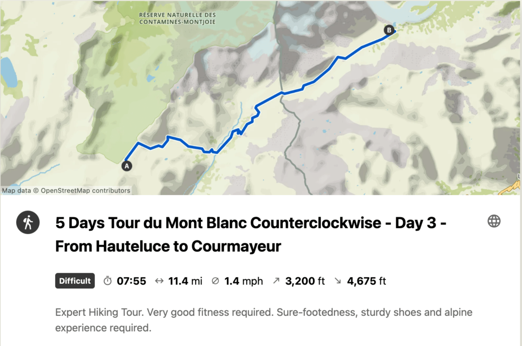
- Stage 4: Rifugio Elisabetta to Courmayeur
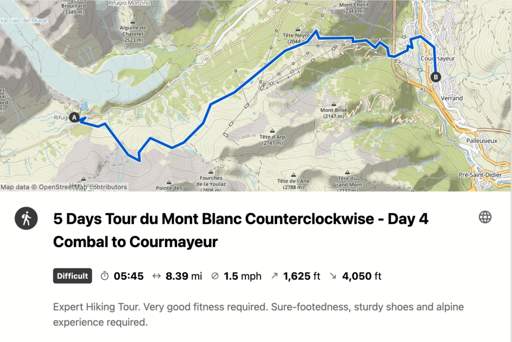
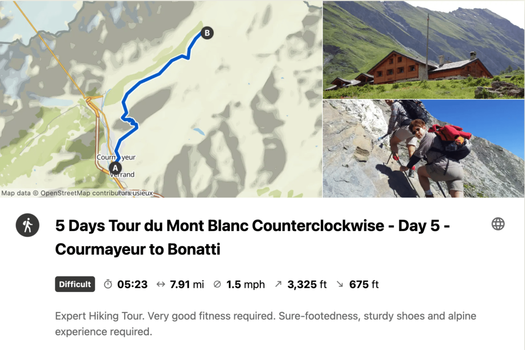
- Stage 5: Courmayeur to Rifugio Bonatti
- Stage 6: Rifugio Bonatti to La Fouly
- Stage 7: La Fouly to Champex
- Stage 8: Champex to Col de la Forclaz
- Stage 9: Col de la Forclaz to Tre-le-Champ
- Stage 10: Tre-le-Champ to Refuge La Flegere
- Stage 11: Refuge La Flegere to Les Houches
To help visualize these 11 stages, we created the Tour du Mont Blanc virtual fly-through video below. Give it a watch to get a sense of the route, terrain, and what you can expect!
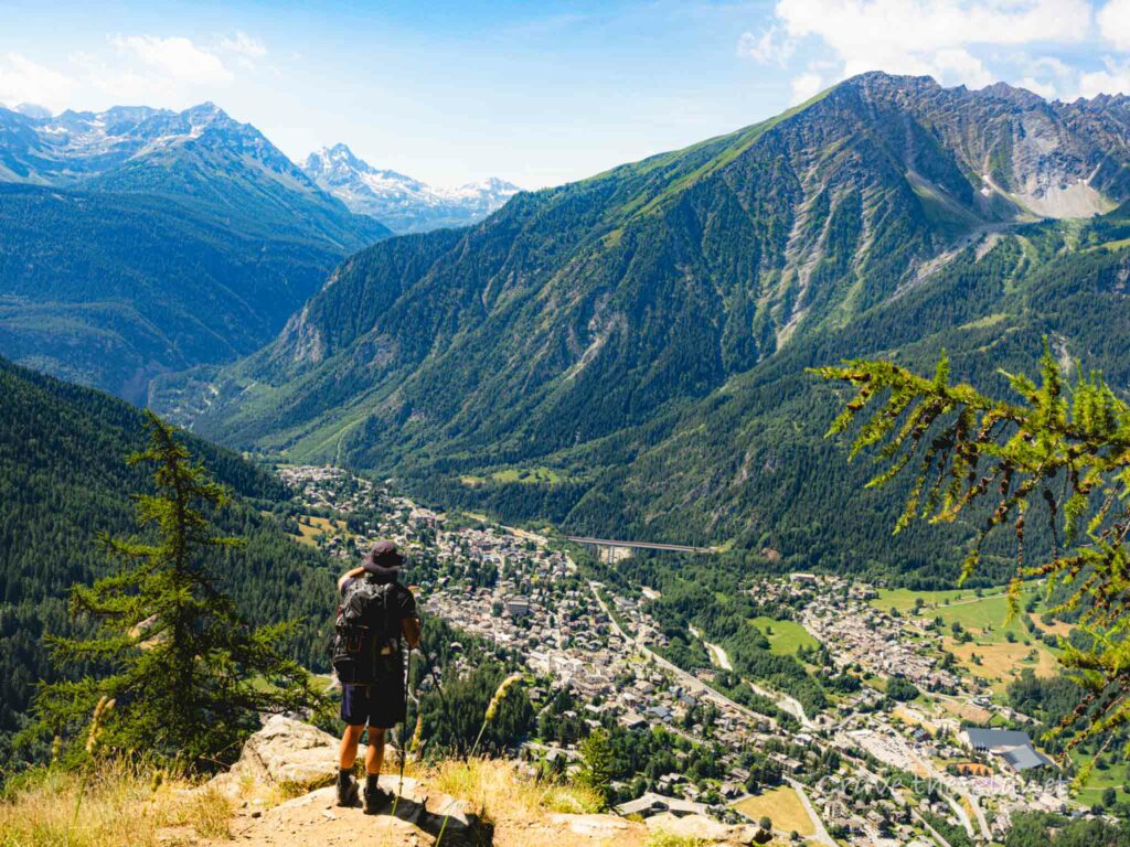
While for many the mere mention of Mont Blanc conjures up images of the famous French mountaineering town of Chamonix, the route of the TMB does not actually go through the town, instead taking a trail high above the Chamonix Valley.
In addition to staying in mountain huts and hotels along the TMB , it is also popular to camp along the route.

In addition to the traditional route, the Tour du Mont Blanc also includes several ‘alternates’. These trails still connect the same start and finish points, but take walkers on a different route between the two points. Alternates can be used to add challenge, avoid certain sections, or lengthen/shorten a particular stage. The map below shows the common alternate routes on the TMB.
These alternate routes include the following:
- Col de Tricot : Alternate between Les Houches & Les Contamines over the stunning Col de Tricot with up close views of the Bionnassay Glacier.
- Col des Fours : Alternate route between Les Contamines (starts at Refuge du Col de la Croix du Bonhomme) and Refuge Des Mottets. Effectively cuts out Les Chapieux stop. This is a rugged and exposed alternate that is best for experienced hikers.
- Tete Bernarda : Alternate route between Courmayeur and Rifugio Bonatti. High level route that has incredible views of the Grandes Jorasses.
- Fenetre d’Arpette: Alterate route between Champex and Col de la Forclaz. Arguably the most difficult stage on the entire Tour du Mont Blanc, but with amazing views.
- Refuge Les Grands : Route that connects the Fenetre d’Arpette alternate route to the Col de Balme via an overnight stay at Refuge Les Grands.
- Le Tour: Alternate route connecting Col de Balme with the village of Le Tour. This is an easier alternate from the main TMB and drops hikers into the valley.
- Col des Montets: Alternate route from Tre-le-Champ that avoids the famed ladder section enroute to La Flegere.
- Lac Blanc: Alternate route that takes walkers to the stunning Lac Blanc and associated refuge.

Interactive Tour du Mont Blanc Map
The interactive Tour du Mont Blanc map below will allow you to zoom in on the various stages as well as view the traditional stops along the route. The map also displays the common alternate routes that are a part of the TMB. You can click on each stage to see the total length, listed in both kilometers and miles.
Get The FREE TMB Essentials Handbook

Our free PDF guide covers all the basics – when to hike, accommodation, typical costs, and more!
Your TMB Essentials Booklet will be emailed to you shortly.
How We Navigate on the Tour du Mont Blanc
If you’re interested in getting access to the GPS data used to create all of the maps in this post, we are happy to offer our Tour du Mont Blanc GPX files for sale. When you download the GPX file, you’ll get route data for each of the traditional stages of the TMB as well as all of the common alternate route, plus waypoints for each stop along the way.
If you want to learn how to use the GPS data to navigate on the trail, be sure to check out our post on How to Navigate on the Tour du Mont Blanc.

You’ll be able to load the GPX file into the mapping software or GPS phone app of your choice!
How Long is the Tour du Mont Blanc
The Tour du Mont Blanc is approximately 101 miles or 162.5 kilometers long. This is based on following the traditional route and not taking any shortcuts or alternates. Of course, few if any walkers will stick to this route exactly. You could easily walk less or more depending on your preferences, route choices, and the conditions encountered on the trail.
The maps below show the approximate distance of each stage in miles as well as kilometers. For more detail on each stage be sure to check out our interactive map in the section above!

What is the Elevation Profile of the Tour du Mont Blanc?
Over all 11 stages, the Tour du Mont Blanc has approximately 37,000 feet or 11,300 meters of elevation change! That averages out to over 3,300 feet or 1,000 meters of elevation change per stage for those who complete the walk in 11 days.
Of course, there will be days with more elevation gain and days with less. Given that the TMB is a loop trail, you’ll ascend and descend the exact same amount over the course of your trek.
The elevation profiles below, displayed in both imperial and metric units, will give you an overview of what each stage of the Tour du Mont Blanc is like in terms of total elevation change and distance. On the charts elevation is shown on the left hand side while distance is shown on the bottom. Each blue dot represents a stop along the traditional 11 stage TMB route, with the stop name shown at the top.
The steepness of the line between any two points shows the steepness of the trail for that particular stage. The distance between the two points shows the length of the the stage. So for instance you can see that the stage from Tre-le-Champ to La Flegere is rather short in distance, while the stage from Les Contamines to Les Chapieux has a lot of elevation gain.

Which Maps Should I Carry on the Tour du Mont Blanc?
The TMB is a very well marked trail with frequent signs and trail markers. As a result, when we hiked the TMB we did not rely heavily on any of the various paper maps that are available for the route. Instead, we preferred to utilize GPS maps on our phones, as described in the next section. However, that doesn’t mean we didn’t bring paper maps with us.
While technology has done a tremendous amount to make navigating while hiking easier, there is simply no replacement for carrying a physical map with you. If your phone runs out of battery or you drop it in a puddle you’ll be glad you had your handy paper maps to rely on.
We recommend bringing the IGN 3630 OT Chamonix and IGN 3531 ET St-Gervais with you, as they provide a detailed view of the TMB route. There is also a single IGN map that covers the entire route , although at a less detailed scale. The table below has an overview of all of the options:

If you want to learn how to use the GPS data to navigate on the trail, be sure to check out our post on How to Navigate on the Tour du Mont Blanc.

You’ll be able to load the GPX file into the mapping software or GPS phone app of your choice!
Tour du Mont Blanc map app/offline mapping
As mentioned above we utilized offline downloadable GPS maps on our smartphones to navigate while hiking the TMB. This is a great way to navigate on the trail as it allows you to see your progress for the day and also isn’t reliant on a cell phone signal to display the map. Our How to Navigate on the TMB post has all the information you need to get set up using an app for your Tour du Mont Blanc map. This step-by-step article will teach you how to quickly and easily turn your phone into a GPS device.
Want more Tour du Mont Blanc content?
- Guide to Camping on the Tour du Mont Blanc
- TMB Packing List
- 10 Essentials for the Tour du Mont Blanc
- How to navigate on the Tour du Mont Blanc
- How to find all of your campgrounds on the TMB
- How to train for the Tour of Mont Blanc
- How to hike the TMB for (nearly) free
- TMB Trip Report
- TMB Photo Gallery
- Tour du Mont Blanc Logistics
- How Much it Cost us to Hike the TMB
- Tour du Mont Blanc Accommodation and Refuge Guide
- Tour du Mont Blanc – Shortcuts, Detours, & Public Transit
4 thoughts on “Tour du Mont Blanc | Maps & Routes”
Many thanks a lot for this article. Decided last minute to do the tour with not much time for planning and investigating info on the trek, distance, elevation, etc. This was of a great help. Thx a Lot !
Hey Veronika, So glad you’ve found the article useful! Hope you have a great TMB! Best, Ian
Most helpful site I have visited. Is there such a thing as a time map which shows the average time when walking each stage
Hey James, Glad you are finding our site useful! We don’t currently have a map showing estimated hiking times for each stage, but that is a great idea. In the meantime we do provide approximate hiking times in our Ultimate Guide to the Tour du Mont Blanc article here . Let us know if you have any other questions, Best, Ian
Leave a Comment Cancel reply

We’re Emily and Ian, outdoor lovers and planning nerds who live in Boulder, Colorado. The only thing we love more than researching and mapping out our next adventure, is actually being out there on the trail. Between the two of us, we’ve been to over 30 countries, and much of our travel in these countries has been on two feet or two wheels. When we’re not in a far-flung destination, we spend a lot of time exploring the amazing camping, hiking, and biking destinations in our home state of Colorado. Learn More About Us
Tour du Mont Blanc
West highland way, laugavegur trail, walker's haute route, coast to coast walk, national parks.
Let Us Help Plan Your TMB!

We’re here to help! We offer comprehensive TMB planning support so you can plan your perfect trip!
TOP 5 CAMPING FAVORITES FOR 2023
1. Rumpl Puffy Blanket - The coziest camp blanket out there.
2. Solo Stove - Elevate your campfire with this smoke-free fire pit.
3. Solar Power Bank Charger - Keep your gadgets charged with the power of the sun.
4. Yeti Tundra 45 Cooler - The ultimate camping cooler.
5. Gaia GPS - Download offline maps for easy navigation! Get 20% here .
- Gondolas, cable cars & trains open May 2024 in Chamonix
- End winter season at Grands Montets Freeride day Sunday 5 May 2024
- Mont Blanc Tunnel closed night of 2/3 May 2024
- Festival 'Montagne en Scène' this Thursday 2 May 2024 in Chamonix
- Mont Blanc Tunnel closed from 2 Sept to 16 Dec 2024
At the foot of Mont Blanc (4808m or 15,770ft), the highest mountain in western Europe, Chamonix's alpine town atmosphere

The resort of Chamonix has three 5 star hotels, eleven 4 star hotels, twenty two 3 star hotels, thirteen 2 star hotels

TransferFix, we help you find your Chamonix transfer

Since 1934, Snell Sports has been the largest mountain shop in the Chamonix Valley.

Compare & Book Online with Chamonix.net
Tour du mont blanc hiking - routes, maps and itineraries.

The Tour du Mont Blanc (TMB) is a 170 km trek that encompasses the whole of the Mont Blanc Massif; with nearly 10 000m of cumulative descent and ascent it is usually completed in a number of days.
The TMB has a variety of accommodation facilities along the route (hotels and mountain huts with possibility for vehicle support) that allow you to really enjoy the scenery, take lots of photos and walk each day with just a light pack.
Alternatively, the TMB can be done completely self-sufficiently: you carry all your own food and camping gear. This gives you a better sense of freedom and the ability to go where you please whenever you want.
Tour of Mont Blanc General Information
Mont Blanc Tour mountain huts are open, in general, from mid-June until the first or second week in September. It is advisable to reserve a bed, particularly in the high season of mid July to mid August.
Early in the season is the quietest and most beautiful, but beware of old snow on the higher paths which could be icy and dangerous and would make an ice axe essential.
For additional safety or to just show you the way you could hire an Independent Trek Leader .
Wildlife on the Tour du Mont Blanc
Have a look at the Chamonix.net nature, fauna and flora page for more information on wildlife you might encounter on the Tour of Mont Blanc. Chamois, deer, eagles and a range of beautiful alpine flowers can all be seen and photographed.
Tour du Mont Blanc Maps, Kit List and Equipment
Lightweight boots and shorts are sufficient as long as there are warm clothes in your backpack. Waterproofs are essential and trekking poles useful. Here are some of the best mountain equipment shops in Chamonix .
Do not forget sunglasses, skin and lip protection. Always carry drinking water and check the Chamonix weather forecast before starting your journey.
Maps for the Tour of Mont Blanc:
Tour of Mont Blanc - Route Descriptions
You have plenty of options: from 4 day sportive hikes to leisurely 12 day cultural experiences; there is not only one way to do the Tour of Mont Blanc. Here are a couple of different suggestions which may help you make up your mind on your particular style.
- You can go on your own with your own GPS track, or benefit from a mountain leader's experience
- You can carry your own gear or hike with a light pack with vehicle support
- You can sleep and eat in the refuges or carry a tent
Here is a list of contact information for the various mountain huts .
4 day trip: Not quite racing - but fast enough: For the hardcore hiker
This itinerary follows pretty much in the footsteps of the Ultra Trail race (which varies slightly from year to year). This is for very fit hikers and is done with only a light day pack, eating and sleeping in huts and is basically the run/walking version of the Tour du Mont Blanc. The times noted are for fit spandex-wearing (not obligatory!) hikers.
7 day trip: Hiking the Tour of Mont Blanc - hiker
Start with the previously mentioned itinerary and break up the days a bit depending on where you would like to spend the night.
For people who carry their own gear, plan on a 7 day trip.
9 to 11 day trip: Taking the time to look at the scenery
Of course if you really do have time, you can expand the experience. Here's an example of a slower pace, with time to veer a little off the path. This is described as an 11 day trip, but it would be really easy to knock off the first and last days as those days are dedicated to trekking in the Chamonix Valley.
Each year, in the last days of August, the trails around the Mont Blanc get really busy. This is because of one of the most amazing human competitions ever organized on this planet - The Ultra Trail du Mont Blanc - so keep this in mind when planning your hike of the Tour du Mont Blanc.

Social Networks

Latest News


Tour Du Mont Blanc Itinerary – 5 Days on the TMB with GPS Map & packing list
We use affiliate links and may receive a small commission on purchases. Read more about us.
5 Day Itinerary for Lightweight Backpacking from Chamonix to Rifugio Bonatti
Explore the French and Italian Alps Hiking Actually Hiking AROUND Mont Blanc with this Tour du Mont Blanc Itinerary.
Do you have a week of vacation and want to maximize your sense of WONDER by:
- Feeling the luscious burn of hiking around Europe’s highest peak –
- Hearing the tinkle of alpine cow bells –
- Tasting cheese from said cows munching wild herbs on the mountaintop –
- Seeing incredible and varied Alpine landscapes, wildflowers and wild animals –
- Sleeping in comfortable beds each night –
- Drinking locals wines and tasty beers on the top of a mountain –
- Experiencing French, Italian and Swiss culture all in one trek –
- and totally UNPLUGGING from the world below….
The Tour du Mont Blanc itinerary hike offers a chance to connect to what really counts and you don’t have to be a mountaineer to do it. Training ahead of time is adviseable, but I followed along a family last year that did it with 2 six year olds and a 2 year old toddler.
Read until the end where you can download and print a packing list with everything you need to do the trek, but keep your backpack light.
Protip: Staying in a mountain refuge is not exactly a hotel. Learn more with my detailed guide to the accommodations on the Tour du Mont Blanc and what the average costs of the TMB are.
A light backpack = A Happy hiker.
Final Verdict: Ways to Book a Hut to Hut Hiking Trip

Self-Guided Tour Planning Service
- [Self-Guided] - You're on your own once you start
- Must book in Oct to Jan of year prior to hike
- Fully done for you route
- Service finds and books your huts
- Maps provided on app
What we liked: The logistics of the TMB and other hut to hut hikes can be very daunting, especially if you don't speak Italian and French.
Note: Lesser known trails are often easier to book.
- Ease of route
- No finding or dealing with huts
- Tapping into expertise
- No waiting for slow hikers
- No feeling rushed if you're slower
- Less control of dates
- No guide on the trail
- Unknown - you didn't "plan"

Guided Group Tour : 4 Days
- small groups (<10 typically)
- local Chamonix guides
- all transfers/breakfast/dinner/accommodations included
- airport transfer included
- stay in the insanely beautiful Rifugio Bonatti and other huts at high elevation
What we liked: Designed for busy people that want to experience the highlights of the Tour du Mont Blanc without having to take 2 weeks of their precious vacation time. Everything is done-for-you and you can show up and relax in the most stunning mountains.
Note: The standard price includes shared rooms in the huts.
- All transfers included
- Best price for a guided trip
- Local Chamonix Guides
- At the mercy of group pace
- Not the full circuit

DIY: Book Your Own Huts
- Cheapest Option
- Most Freedom
- Take side excursions as you like
What we liked: The challenge of it. It's so fun to route plan, find trails and the huts you want. Often it's not the expense saved, but the learning of the trail while planning that is satisfying.
Note: Be prepared to spend some time with spreadsheets and wait weeks for replies from hut owners. BONUS: Click on the link to watch my 10 part video series on HOW to book a hut to hut trip. It's a Dolomites hut trip but it's basically the same process for TMB.
- Cheapest option
- Most freedom
- Learn the Trail by planning
- You must be organized
- Map skills are essential

- campgrounds can be crowded
- reservations often needed in advance
- Wild camping is prohibited or limited by elevation
Not really my favorite thing for hut to hut trails in Europe. The huts are quite often the best part of the hiking trip and the rules are so complicated about wild camping.
- Price is good
- More Flexibilty
- Wild camping is tricky
- Rules change
- harder and heavier pack
5 Days Itinerary TMB Map

Magical 5 Day Backpacking Trip Around the highest Peak in Europe
Example tour du mont blanc itinerary.
Follow along my journey of planning my first time hiking the Tour du Mont Blanc. The past 3 years I’ve planned summer hiking treks in the Dolomites and this year I wanted to tackle the famous Tour du Mont Blanc that spans 3 countries. You actually start in France, walk to Italy and then Switzerland and back to France. Very Cool!
I got started in December to book mountain refuges and found limited offerings on this top-rated trekking trail in Europe . Next time, I would begin the work early in September to book refuges.
We were limited to less than a week for travel so I picked the best 5 days on the trail that made sense for our group of travelers.
Tour du Mont Blanc in 5 Days
Tour du mont blanc backpacking trek.

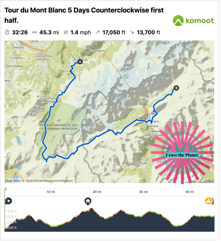
5 Day Section – 1st Half Location: Mont Blanc, France & Italy Distance: 45.3 mile Loop with Bus Time: Approximately 5-7 hours daily Elevation: 🔼17,050 ft 🔽13,700 ft Difficulty: Moderate due to rocky terrain and elevation gain Where to Stay on Final night: Armancette Hôtel, Chalets & Spa in Chamonix
Tour du Mont Blanc Itinerary for 1 Week of Vacation
It would be so nice to do the entire circle around Mont Blanc, Europe’s highest peak. However, my friends and I work at jobs that prohibit taking off weeks at a time to go trekking. So the next best thing is to do the first half of the trail and plan it so that we spend the least amount of time on buses.
Fortunately, there’s a tunnel under Mont Blanc with bus service so it makes it easy to begin hiking at the traditional start in Les Houches and walk 5 days to Rifugio Bonatti and take a bus back to the start.
Getting to the Tour du Mont Blanc
Geneva is the closest airport where you can rent a car or take a regularly scheduled bus to Chamonix. Once inside Chamonix you can walk everywhere within the town.
2 Days in Chamonix
Chamonix is a nice place to relax before the hike because there are many hotels, restaurants and things to do and it’s a 15 min drive to the trailhead in Les Houches.
The day before the hike we will take two cars the end of our hike near Rifugio Bonnati and park the big car in a free public parking lot. Both drivers will then return to Chamonix and we’ll leave a car there.
Without cars you can utilize bus ARRIVA I59055 towards Funivia Sky Way (30) to return to Chamonix from Courmayeur. In effect you’ll walk one way and take the bus back to the start. There are many buses that connect Geneva to Chamonix and Chamonix to the trailhead in Les Houches. Check the bus timetables here .
Tour du Mont Blanc Difficulty
This hike is not especially technical but it’s certainly challenging due to the amount of elevation change. Prepare your knees and bring your trekking poles because 🔼17,050 ft 🔽13,700 ft is a lot over 5 days. I’m going to guess that the decent to Courmayeur at the end of the day will sting a bit.
Stages Tour du Mont Blanc Itinerary 5 Days
From luxury alpine town in france to luxury alpine town in italy by foot.
Arrival Day: Get to Chamonix, France. Stay there the night before big hike and get a lot of sleep. There are many bus and private taxi or van connections from airports such as Geneva, Switzerland.
Tour du Mont Blanc Route
Get a hiking app for your Mont Blanc itinerary that is GPS enabled and download your track to your phone before the hike. This will ensure your phone can help you stay on the correct trail even without service. I like Komoot because you can plan day by day and have planned this TMB hiking trip here. But you can use whichever one is best for your TMB itinerary.
Tour du Mont Blanc Hike Map
If you are new to the world of hiking apps please read my article on how to use komoot app for hiking. It’s a total game changer and not really that hard to learn. I’m a huge fan of the multi-day option for paid subscribers. It gave me options on all the accommodations nearby the trail to make it really easy to plan distances.
Tour du Mont Blanc Trail
Stage 1: les houches to les contamines.
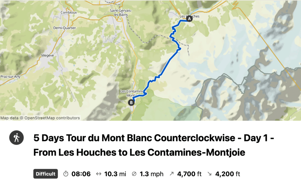
Monday July 10 – Day 1:
Hike 16.4 km
Enjoy a relatively easy warm up to the trail and we can use the gondola to shave off some elevation gain if we want. Stop at Auberge Truc for lunch.
Stage 2: Les Contamines to Refuge du Col de la Croix du Bonhomme
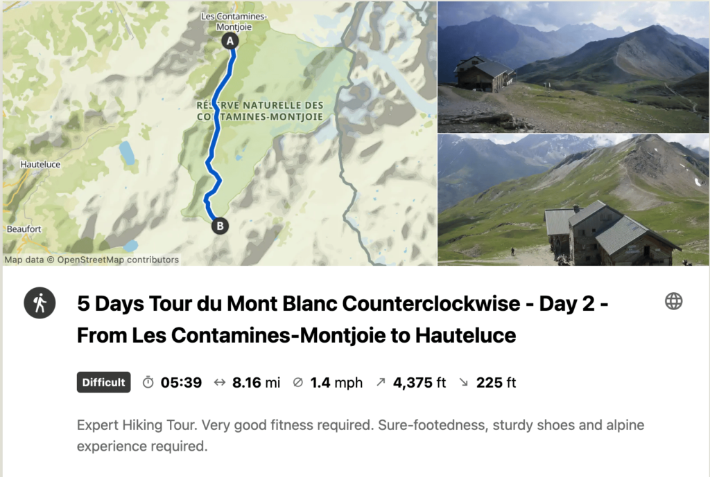
Tuesday July 11 – Day 2:
Hike 13.13 km
We will be going pretty much in one direction today, up.
Stage 3: Col de la Croix du Bonhomme to Cabana Combal
Wednesday July 12 – Day 3:
Hike 18.3 km
What a day! Views of glaciers and Mont Blanc almost all day.
Stage 4: Cabana Combal to Courmayeur
Thursday July 13 – Day 4:
Hike 14.4 km
We’ll descend into the Italian mountain town of Courmayeur and stay in a real hotel tonight and hopefully spend some time on the cobblestone town center eating delicious Italian food.
Stage 5: Courmayeur to Rifugio Bonatti
Friday July 14 – Day 5:
Hike 11.6 km
We’ll climb uphill all day with incredible views to the Bonatti rifugio. It’s a short day so we may opt to do some dayhikes from Bonatti or side excursions.
I’m planning for us to park the second car at Parcheggio Lavachey near Bonatti prior to the hike. It is a 3.3 km walk from the rifugio to the parking lot. There’s a restaurant nearby so I’m assuming it’s passable in summer.
It’s a 45 min drive thru tunnel back to Les Houches where the other car will be parked.
Where to Stay Directly on the Tour Du Mont Blanc Trail
Accommodations on the tour du mont blanc trail.
What is a refuge? Generally speaking they are high elevation accommodations of varying amenities. They are called refuges, rifugios, huts, or hütten, depending upon which language is spoken.
They range from luxurious to very spartan. Some have water, some run out. It all depends. But what is universal is that they are a pain in the butt to book. However, they are perched in some of the most beautiful and isolated landscapes in the world. As an American, i can hardly believe that such a thing exists. And they usually serve delicious 3 course dinners and have a breakfast with yummy coffee and lots of bread.
TMB Mont Blanc
Day 0 – arrival day in chamonix.
You’ll want to find your own accommodations in Chamonix prior to the hike. I would recommend to book your hotel on this website as it’s reliable to find a comfortable stay within the town of Chamonix or nearby. It’s a compact Alpine town and you can easily walk to dinner along the stream. It’s very ritzy and fun.
Day 1 – Les Contamines Airbnb
As of December 5, I couldn’t find any huts, campgrounds or booking.com places available for our date in early July before the high season. Whew. But I did find a chalet to fit the 6 of us with 3 bedrooms somewhere near the town of Les Contamines. It’ll be an easier day of hiking but that’s good for warming up.
Day 2 – La Croix Bonhomme Refuge
Hopefully it’s not raining because this is a true mountain hut on the top of a mountain with panoramic views. The facilities are super basic but that’s the point. It’s a respite from the world below.
Dormitory style prices for 2023:
26.50 bed 32.50 breakfast and dinner 8.00 sack lunch
Contact La Croix Bonhomme Refuge
No credit cards. You’ll want to bring a sleep sac which is like a liner to protect against bed bugs, lice, etc. They don’t want your body grease on their pillows and blankets basically. They should have showers especially in early July but you’ll probably have to pay for them and it’ll be quick, like 90 seconds. Bring your own quick dry towel and mini tolietries.
Other refuges in the area: Les Mottets
Day 3 – cabane du combal refuge.
A nicer hut from online reviews, we’ll see. The prices are higher and I’m assuming it’s half board, their website is pretty basic and it’s hard to tell. They use the https://reservation.montourdumontblanc.com/ site to book but do reply to emails. I did not have pay a deposit but we got room 4 and room 6. We’ll have to do a competition to decide which couple gets the whole room to themselves.
4 person room prices for 2023:
90.00 euros per person.
They have towels and soaps here.
Other refuges in the area: Rifugio Elisabetta
Day 4 – courmayeur.
Here we’re in a glitzy Italian alpine town so there are hotel and airbnb options. I used Hotel Triolet because they offer a nice breakfast and comfortable looking rooms.
Double room prices for 2023:
160.00 euros per room including breakfast.
We should plan to have a nice dinner out in town and soak up the cobblestone pedestrian areas and maybe even do some shopping.
Other accommodations in the area: Check on this Hotel Website
Day 5 – rifugio bonatti.
A hut with great views and isolated up the mountain from the valley where Courmayeur is located. It’s likely not to have great services but it’s half board and there’s not a lot of other options. We have 1 private room for 2 people plus extra bed and one private room for 3 people. Girls and guys? Who snores the least?
L’équipe del Rifugio Alpino Walter Bonatti
3 person room prices for 2023:
85.00 euros per person half board.
Other refuges in the area: Chalet Val Ferret
Packing list for the tour du mont blanc.
💡 It’s not about what you bring, it’s about what you don’t bring.

Not sure what to bring?
Go lightweight. It’s not necessary to bring a lot of stuff on a hut to hut hike. The huts (refuges) provide the food, beds, toliets, etc. Most people wash out their hiking clothes and hang to dry each night.
The refuges or mountains huts allow you to bring very little in your backpack. The lighter your pack is the more happy of hiker you’ll be. There are some services to do luggage transport to the refuges, however this goes against the idea of responsible travel. There’s really no need to make someone drive your luggage up to a mountain hut, or worse, load up a mule with your crap.
You’ll be hanging out with other hikers each night in the refuges to have dinner. Realistically, you’ll need one set of lightweight clothes that don’t stink to enjoy the dinner and breakfast services.
It’s totally kosher to wash out your hiking clothing and hang them up on the railings or provided laundry lines (at some refuges).
Printable Tour du Mont Blanc Packing List

Click here to download free PDF Tour du Mont Blanc Packing List
Costs of the Tour du Mont Blanc
Accommodations on trail, you can go pretty lux in the towns of courmayeur and chamonix if you choose..
Please see the detailed Airtable towards the end of the article where I’ve documented the costs for the year 2023. But in summary inflation is hitting everywhere:
–in towns, you’ve got more options for hotels & airbnbs that run 135 euros for a double and up
–The mountain refuges with half board range between 67 to 90 euros per person per night
–Of course, the earlier you book you may find better deals.
–Sack lunches are quoted at 11 euros
–Meals in town at restaurants have increased recently to 15 euros and up per meal
When to Hike the Tour du Mont Blanc
Mid-june to mid-october is when the huts and trail are open., the alps in august can be crowded.
–August is Italian/French/German vacation time, so you’ll be in high season.
–July has the best weather for families that need to do this trek during school break.
–Early June is chilly you can run into some snow. Same for late September and early October.
If you aren’t going with kids, early September would likely be the best as it’s least crowded and still warm.
However, there are absolutely no guarantees on weather. You’ll probably hit thunderstorms in the late afternoons so most people tend to get to their rifugios before 3 pm.
Read my full guide on when to hike the tour du mont blanc .
Resources to Plan Your Tour du Mont Blanc Hiking Trip
1. I started with the Montourdumontblanc website to assess the high mountain refuges. However, not all of the options are on this site, but it’s a great starting point and has a nice interactive map. These places are only open mid June to Mid October.
https://www.montourdumontblanc.com/uk/index.aspx
2. Google maps. Duh.
3. A great itinerary to do the entire Tour du Mont Blanc in 7 days . The author gives nice descriptions of the landscapes and it may suit more advanced hikers who want to move faster and cover more ground each day.
4. You can use travel sites like Airbnb and Booking to find hotels in Chamonix , Les Houches, Courmayeur and Les Contamines as they have offerings in the valleys.
5. The T our du Mont Blanc Facebook group is a wealth of inspiration and information.
6. Private car transfer Chamonix to Geneva Airport .
7. Customized Airtable TMB Planne r. I built this Airtable to keep myself organized and track the expenses. Copy and paste it to make it your own.
8. Detailed guide on how to use trekking poles and best budget trekking poles buying guide . You will definitely want them on this trek.
9. Plan your hiking time with a calculator.
10. Read my guide on how hard the Tour du Mont Blanc hike is.
Tour du Mont Blanc Self Guided Itinerary – Help
If it all seems to much to plan, you can hire a service to take care of the logistics but not have to utilize an in person guide.
Businesses such as Alpenventures Unguided will do the heavy logistical lift for you. You can simply just show up and hike. They will book your huts and provide maps and directions to do the hike on your own terms.
If I had a little more cashflow I’d use this to save about 20 hours of emailing back and forth and managing spreadsheets.
Guided Tour du Mont Blanc
There are also guided tours if you want a local mountaineer to walk with you for extra safety, context and fun. Cloud 9 Adventures and Mont Blanc Treks offer the Classic Tour du Mont Blanc, mini TMB treks and other variations that are led by a professional guide to ease your stress.
Other Great High Alpine Multi Day Hut to Hut Hikes in Europe
Italian Dolomites vs Tour du Mont Blanc? Are you curious about the other bucketlist hut to hut hiking trip in Europe’s high mountains? Our family has done the Alta Via 1 in summer 3 times so we’ve got a lot to say. Mostly about the food.
💞 Podcasts? Listen to our 3 different long form stories about hiking the Alta Via 1 on multiple trips that we’ve done with family and friends over the years. 🥾 Trails Worth Hiking Spotify , Apple , Website . He takes a deep dive into long distance trails and the history and mythology behind them. 🎧 Amateur Traveler focuses on the practical travel and highlights history : Website , Spotify , Apple . 🍻 Streets and Eats is all about the food and experience : Website , Spotify , Apple .
Author profile : Morgan Fielder is a Doctor of Physical Therapy and passionate hiker who believes in exploring the world on foot with good food. Follow her journey as she shares science-based hiking tips and advocates for sustainable tourism.
- Trail Guides
- App Features
- General FAQs
- Subscription FAQs
- How-To Guides

170km / 105 miles • The Alps of France, Italy & Switzerland
Official companion app to trailblazer’s tour du mont blanc by jim manthorpe.
Download our guide to access the Tour du Mont Blanc map, tracks, waypoints, and comments! Trek the European Alps through the epic peaks and stunning valleys of the Tour du Mont Blanc. The Tour du Mont Blanc is one of the world’s most famous hiking trails. This loop route passes through seven stunning mountain valleys around the spectacular Mont Blanc. This amazing scenery is classic European Alps: rugged spiky mountains, lush green valleys, strenuous mountain passes, and photo-worthy vistas. Hikers can start the loop from a variety of points in France, Italy, and Switzerland, including in Les Houches in the Chamonix Valley, Les Contamines in the Montjoie Valley, Courmayeur, Champex, and Martigny. The route also passes Chamonix, the famous resort which hosted the first Winter Olympic Games in 1924.
$14.99/£14.99 A TRAILBLAZER GUIDE
Buy Once, Works Everywhere
Works Offline
Trusted Trail Data
Detailed Waypoints
Built for Community
Tailored to You

Available on
- Desktop browser
- Android tablet

Trailblazer Special
Purchase all Trailblazer apps in one package. Includes South Downs Way, Coast to Coast, West Highland Way, Hadrian’s Wall Path, The Cotswold Way, and The Ridgeway. Purchase now and you will receive any new apps we add in the future at no additional cost.
$34.99/£34.99
Tour du Mont Blanc
The Tour du Mont Blanc is one of the world’s most famous hiking trails. This loop route passes through seven stunning mountain valleys around the spectacular Mont Blanc. This amazing scenery is classic European Alps: rugged spiky mountains, lush green valleys, strenuous mountain passes, and photo-worthy vistas. Hikers can start the loop from a variety of points in France, Italy, and Switzerland, including in Les Houches in the Chamonix Valley, Les Contamines in the Montjoie Valley, Courmayeur, Champex, and Martigny. The route also passes Chamonix, the famous resort which hosted the first Winter Olympic Games in 1924.
$14.99/£14.99

About Our Partner
Trailblazer was started in 1991 by traveller and author, Bryn Thomas. In his travels since the 1980s he has used a lot of guidebooks and firmly believes that it is the detail that makes guides most useful. Walkers need to know the nut and bolt detail of a walk – timings, distances, gradients and prices – rather than have to read long descriptions of views they can see for themselves. So Trailblazer guides focus in on really detailed information for only a single long-distance walk or a select few trails rather than general information on a large network of trails. And our authors have a voice – they tell it like it is. These are guides are written by walkers for walkers. Trailblazer is proud to have been associated with FarOut since 2014 and we work closely together.
- Best Hikes In The World
- Appalachian Trail
- European Hikes
- Nepal Hikes
- Patagonia Hikes
- See All Hikes
- Mount Kenya
- Mount Kilimanjaro
- Mount Toubkal
- See All Mountains
- South Africa
- New Zealand
- Switzerland
- United Kingdom
- Packing Lists
Tour du Mont Blanc (Expert Guide)

Europe , France , Hikes , Italy , Mountains , Switzerland

The Tour du Mont Blanc is one of the most popular treks in Europe. It covers a distance of roughly 170 kilometres and gains more than 10,000 meters of altitude over 11 stages.
In this guide we cover: what weather to expect and the best time to hike the Tour du Mont Blanc, which huts to book, what gear you might need, and much more...
Join a Tour du Mont Blanc Highlights Hike
Book with our recommended local guide
Tour du Mont Blanc
Route overview.
The Tour du Mont Blanc covers a distance of roughly 170 kilometres and gains more than 10,000 meters of altitude over 11 stages. Most people start their hike in Les Houches, France going in an anti-clockwise direction.
During this trek you will hike in the French, Italian and Swiss Alps and spend the night in mountain huts. This is one of Europe's best hikes and is a classic alpine trek. On the hike you will get splendid views of some of the highest mountains in Western Europe, as well as glaciers and alpine meadows.
The highest point reached is 2,665 meters.
The hike passes seven valleys along the way, which means there is a lot of altitude to be gained, making the Tour du Mont Blanc a physical challenge.
Fortunately, walkers are rewarded with some of the best views you can get of Mont Blanc . The route is not only one of the most beautiful long-distance treks in Europe (up there with the Walker's Haute Route ), but one of the most popular ones as well.
Nights can be spent in either mountain huts along the route or back in the valley, where you can have the luxury of a warm bed in a hotel.
What we like and dislike about the hike
- Incredible views of the Mont Blanc massif
- Hike in three countries
- Visit the beautiful villages of Chamonix and Courmayeur along the way
- Spend the night in some of Europe's most iconic mountain huts
- More expensive than other treks in Europe due to the cost of mountain huts
- Physically challenging
- Can be crowded during the summer months
Join the full Tour du Mont Blanc Hike (10-Days)
Tour du mont blanc circuit.

Source: chamonix.net
This map illustrates the Tour du Mont Blanc route. It starts off at Les Houches, France close to the Swiss and Italian border before heading west towards the Italian side of Mont Blanc.
There are 11 stages depending on your physical level. The route is circular around the Mont Blanc Massif, crossing the borders of France, Switzerland and Italy.
In terms of a trekking map we recommend:
- Chamonix, Mont-Blanc ~ IGN Top25 3630OT 2012 (English and French Edition)
And in terms of a trekking guide we highly recommend:
- Cicerone's The Tour du Mont Blanc: Complete two-way trekking guide
Altitude Profile
In the chart below you see the altitude profile of the full hike. It is quite clear there is a lot of altitude to be gained over the 11 stages, with the highest point reached just above 2500 meters. You can see that there are a few strenuous stages reaching high mountain passes that will require great effort.

Mont Blanc Route Itinerary
Below we have laid out the most popular version of the Tour du Mont Blanc Route – 11 days, starting and finishing in Les Houches. The itinerary includes approx. distances, hiking times and elevation changes.
Day 1: Les Houches – Les Contamines
Distance: 16 km Ascent: 646m Descent: 633m Hiking time: 5hrs
Easy first stage along, this is the most roadway you will see during the trek. The best views are to be seen at Col de Voza, where you get a look at Dome du Gouter and Aiguille de Bionnasay, with the glacier splitting it in half.
Day 2: Les Contamines – Les Chapieux
Distance: 18 km Change in elevation: 1316m+, 929m- Hiking time: 7.5hrs
A bit tougher than the first stage. Especially, since there is quite some altitude to be gained and distance covered.
Day 3: Les Chapieux – Rifugio Elisabetta
Distance: 15 km Change in elevation: 1004m+, 258m- Hiking time: 4.5hrs
This is the day you will leave France and enter Italy via Col de la Seigne. Despite being a short day, there still is some elevation to be gained as you will pass Col de la Seigne. At the highest point, you will gain some great views of both France and Italy and gaze into Val Veni. This is the first night you will spend in a mountain hut.
Day 4: Rifugio Elisabetta – Courmayeur
Distance: 18 km Change in elevation: 460m+, 1560m- Hiking time: 5hrs
Another short day, since you will mainly be descending. Still, some great views will be shared before reaching Courmayeur, the Italian equivalent of Chamonix.
Day 5: Courmayeur– Rifugio Bonatti
Distance: 12 km Change in elevation: 860m+, 101m- Hiking time: 4.5hrs
Often described as the most scenic stage of the Tour du Mont Blanc. With views on the glaciers of Planpincieux and Frebouze it’s not hard to see why. The high route along the Mont de la Saxe Crest is thought of as one of the best viewpoints of the southside of the Mont Blanc.
Day 6: Rifugio Bonatti – La Fouly
Distance: 20 km Change in elevation: 895+, 1410m- Hiking time: 6.5hrs
Today will cross another border and enter Switzerland. Cowbells and tiny villages that have been stuck in time are your scenery for the next few days.
Day 7: La Fouly - Champex
Distance: 15 km Change in elevation: 420m+, 565m- Hiking time: 4hrs
This probably is the easiest stage of the Tour du Mont Blanc since there are no cols to be conquered. This stage mainly is a valley trek with some great charming villages along the way. However impressive views of the mountains remain.
Day 8: Champex – Col de la Forclaz
Distance: 16 km Change in elevation: 742m+, 682m- Hiking time: 4.5hrs
There are two ways to reach Col de la Forclaz. A lower route via Alp Bovine, or the more scenic and higher route along the Trient Glacier. This latter passes the Fenetre d’Arpette, the highest point on the Tour du Mont Blanc, and should only be considered in good weather.
Day 9: Col de la Forclaz – Tre le Champ
Distance: 13 km Change in elevation: 1069m+, 1168m- Hiking time: 5.5hrs
From this point you re-enter France via Col de Balme. A lot of elevation is to be gained and lost, which makes the stage a strenuous one.
Day 10: Tre le Champ – Refuge Flegere
Distance: 8 km Change in elevation: 733m+, 257m- Hiking time: 3.5hrs
Short stage, but with some ascent. You will spend another night in a mountain hut. Refuge Flegere offers great views and is a perfect last night in the mountains before arriving in Les Houches the next day. There are some ladders to be climbed before reaching the refuge however.
Day 11: Refuge Flegere – Les Houches
Distance: 17 km Change in elevation: 772m+, 1546m- Hiking time: 6.5hrs
This last stage of the Tour du Mont Blanc goes along Le Brevent in the Aiguille Rouge. There are some splendid views of the Chamonix Valley before finally descending and arriving back in Les Houches.
Video Overview
A beautiful video overview, filmed with a GoPro, of the Tour du Mont Blanc by Eugenio psnt .
Join a Tour du Mont Blanc Hike
Frequently asked questions, how much does the tour du mont blanc trek cost.
The cost of the Tour du Mont Blanc trek is dependent on whether you plan to do a self-guided hike or join a planned tour. Self guided hikes cost in the region of $1500 (estimate of $50-$75 dollars a day). Most mountain huts / gites are around $50 (incl. breakfast).
Guided trekking tours can be quite expensive since not only do you pay for the guiding service, but you eat and spend most nights in hotels or mountain huts. This mostly includes a luggage transfer to your next accommodation as well, so you can hike with a small backpack. Guided tours range from $2000-$3500, depending on the company / season / size of the group.
Self guided is the cheaper option, however, it does mean you carry more weight in your backpack and some planning of logistics in the weeks / months before.
Are permits required for the Tour du Mont Blanc trek?
No permits are required for the Tour du Mont Blanc trek.
When is the best time to trek the Tour du Mont Blanc Route?
The best time to trek the Tour du Mont Blanc is between July-September, but exact start and end dates depend on the amount and timing of the previous winter’s snowfall and the onset of cold weather in the Autumn.
Since the Tour du Mont Blanc crosses high passes, snow could create problems / dangerous conditions. Therefore in a normal year it is not advisable to set out before July. In the summer months, mid-July through to end of August, are the busiest, and temperatures during the day can rise to 25 degrees. Nonetheless, thunderstorms or a dump of snow is possible as well.
By the end of September, huts will close and it might get a lot harder to complete the trek.
Is altitude sickness a risk?
No, you will cross passes slightly higher than 2500 meter and since you’re hiking slowly to this altitude, you have more than sufficient time to acclimatize. Most people don’t feel any symptoms of altitude sickness before reaching 3000-3500 meter.
How difficult is the Tour du Mont Blanc trek?
Hiking the Tour du Mont Blanc comes with great rewards. Rewards that will be more easily gathered when physically fit and mentally attuned. There are many steep and uphill sections to conquer, so exercising regularly at home before the trek is necessary to get in shape for the physical demands of this route. Mental fitness is as important and often go hand in hand.
The Tour du Mont Blanc is doable for any fit mountain walkers who are able to hike between 5h and 7h30 min per day for several days in a row.
If you are finding the trek tough there are a few sections where you can use public transport to shorten your hike.
What gear do I need?
To do a serious trek like the Tour du Mont Blanc, appropriate clothing and equipment is a must.
Some comfortable lightweight trekking boots are a must to enjoy this trek, while good waterproofs might be essential, not only to protect you against rain or snowfall but to double as wind-proofs. Since you’ll be crossing passes of more than 2500 meters, gloves and several layers will prove useful. Trekking poles are a good way to not overload your knees and ankles
To help you plan and prepare for your trek we recommend our Tour du Mont Blanc packing list .
What travel insurance do I need?
Trekking insurance is important when going into the mountains. See our article on insurance for more information.
Do I have to carry my own gear all the way?
It’s up to you. There are many organisations offering guided trips for this hike, meaning they do all the logistics for you. This often includes a luggage transfer to your next accommodation in the valley, so you only need to carry a small backpack with some lunch, snacks and clothes.

Browse more hikes in Europe
See our top European hikes picks, or check out these popular hikes.
- Tour de Monte Rosa
- Walkers Haute Route
- Camino de Santiago Routes
- Cinque Terre Hiking
- West Highland Way Hike
- El Caminito del Rey
- Laugavegur Trail
- Kungsleden Trail
- Rota Vicentina
- Slovenian Mountain Trail
About the author
Mark Whitman
Mark has trekked extensively in Asia, Europe, South America and Africa. He founded Mountain IQ in 2014 with the sole aim to be the best online information portal to some of the most popular mountain destinations around the world. When not writing for Mountain IQ, Mark is out exploring the outdoors with his wife!
Leave a Reply
Your email address will not be published. Required fields are marked
Hi Dempsey,
I’ve been thinking about doing that hiking for a long time and I think, after this pandemic crisis, it’s the time to see my dream coming true. I hope to do it as soon as possible, and to see it how beautiful the nature around is. Stay safe,
João Leite.
Wife and I are interested in doing this in last half of August. I know it is (too) late to reserve now. We plan to show up and hope for the best, perhaps taking advantage of late cancellations on a guided/luggage transfer arrangement. Any advice?
Hi Mike, there are a few dates available on this TMB highlights tour, which is amazing if you’re looking for a short circuit: https://www.skyhookadventure.com/trips/tour-du-mont-blanc-highlights
We work with local guides to offer great value adventures at unbeatable prices
Planning for the Tour du Mont Blanc
After reading this Trek article almost two years ago, I put the Tour du Mont Blanc on my bucket list and mostly forgot about it. Until this past November, when I started longing for warmer weather and snowless hiking. As I tend to do when I’m nostalgic for my hiking fix, I started researching potential trips. Since I had finished my section hike of the Appalachian Trail in August 2017, I needed new trips to obsessively plan while I was in the throes of winter depression. I decided that for this summer, I wanted a hike that was something I could do in one shot and not have to break into sections. And I really liked the idea of getting out into the larger world, and backpacking around the Alps sounded like a blast. So I started planning. All I can say is, thank goodness for Google Translate.

How to Hike Tour du Mont Blanc
1: overview.
The Tour du Mont Blanc (TMB) is a loop hike of ~110 miles with ~30,000 feet of elevation gain (and subsequent loss) that circumnavigates Mont Blanc massif, a 16,000-footer in the Alps. The trail’s highest point is 8,700 feet, which is not high enough to cause altitude sickness in most people. It’s easiest to fly into Geneva (though there are many other options for transportation if you want to get creative and fly into other parts of Europe), and then take a bus or shuttle the 1.5-hour drive to Chamonix (pronounced sha-mo-nee), France, where most people start and end their hike. The trail goes through France, Italy, and Switzerland. It’s typically hiked counterclockwise, to make the elevation more gentle and put better views at the end. The trail has a classic route, with many variants as options to make it more challenging or, in one case, to avoid a section with metal ladders.

Courtesy of Flickr
It’s a popular trail for Europeans going on vacation during their summer break – July and August. Some Brits go adventuring on the Tour du Mont Blanc as well, but it’s pretty uncommon for Americans. Of the people who hike the Tour du Mont Blanc, something like 95 percent of them are either on a guided or self-guided tour. Unsurprisingly, it costs a lot to pay someone else to plan this for you; I saw anywhere from $1,000 to $5,000 beyond the actual costs of the reservations. Many places offer the option of having your bag carried from hut to hut by donkey. If you’d like to pay REI $5,400 (doesn’t include transportation costs), you can do the Alps in style.

It’s worth noting that none of the guided trips and very few of the self-guided trips I found offer the option to hike the entire Tour du Mont Blanc . Almost every single one cuts out portions of it, and uses chairlifts to avoid longer ascents or descents. This didn’t sit well with me; I wanted to hike the entire Tour du Mont Blanc end to end, and I wanted to know where we were going and why. And I’m very frugal and the idea of paying someone else to plan my trip was physically painful to me, so I dug into it on my own.
The most popularly recommended guide book by far is The Tour of Mont Blanc: a complete two-way trekking guide by Kev Reynolds . It’s a comprehensive guide to hiking the Tour du Mont Blanc, offering a lot of description about the trail’s surrounding landscape, with information about lodging, services, and towns. As a whole, they mainly offer phone numbers for each place of lodging, though sometimes websites are noted as well. I would recommend purchasing the book ($18) if you’re thinking about doing the Tour du Mont Blanc – it is worth the money. However, as a number-crunching hiker, it didn’t offer me quite what I wanted. The distance was only provided as totals for each section and the elevation profiles were so small, they were relatively worthless. I wanted something like The AT Guide or the Thru-Hiker’s Companion . As I couldn’t find this information anywhere, I ended up making my own mileage and elevation tables in Excel. I also ended up purchasing this map ($20); it took me a bit to find the Tour du Mont Blanc on the map, but once I did, it helped me with my planning process. There is also a really helpful interactive map here on the Autour du Mont-Blanc website.

For those who might want to tent camp the Tour du Mont Blanc, know that it’s more complicated than it might first appear. Not only can it be challenging to bring camping gear on an airplane, it’s illegal to wild camp along the entire TMB, except in emergency situations above 2,500 meters, including outside a hut. While there are often campgrounds in or near towns, it can make your mileage more complicated. Or you could do dispersed camping and risk the consequences of being caught – $650 fine per tent. Besides, who wants to carry a heavy pack when you really don’t have to? And showers every day can be so nice! There are a number of online resources available discussing the Tour du Mont Blanc as a tenting vacation, if desired. If I like the TMB, I may return in the future with a tent, but for now, I’d just as soon reduce the number of things that I need to worry about.

2: Transportation and Travel Dates
So first things first – what time of year to hike the Tour du Mont Blanc? Most hostels don’t open until mid-June, because there can still be substantial snow in the mountains up until the beginning of June. If you’re hiking the Tour du Mont Blanc in June, it’s recommended that you check that huts and hostels will be open and bring traction devices like Microspikes. Yearly snowfall makes a difference, and if it hasn’t melted yet, some sections of the Tour du Mont Blanc can be completely impassable in June. July through mid-August are busier times of year, with Europeans on break, and July gets more rain than August or September, though all services are open and you’ll have warmer weather. Mid-August through the mid-September are generally nicer, with less people, less rain, and cooler weather. However, many hostels close in mid-September, so it can cut down on your lodging and refueling options if you go any later than that. And oh, there’s also an ultramarathon of the TMB each year in mid- to late August, so you may want to avoid those dates; it will be an absolute zoo. I had wanted to hike in mid-June but due to work and other summer hiking plans, I was locked into hiking this trip in mid- to late-July.
I used Google Flights , Scott’s Cheap Flights , and FareCompare to track the cost of various flights. Google Flights is a good tool to compare different departure locations; for my location, Boston was by far the cheapest. I kept an eye on the deals and jumped at round trip tickets for $633 per percon back in January. Most flights to Europe during the summer quickly work their way towards $1,000+ for a round-trip ticket. Buy earlier, and keep your eye out for flash sales.
Our economy tickets include one free checked bag. For the flight there and back, I’ll be putting my backpack inside a duffel bag that can be packed down once we arrive. The first hostel we’re staying at in Les Houches will hold a small bag for a euro per day, so we may leave the packed duffel bags and some town clothes in a small bag with them and retrieve them when we stay there again on our next-to-last night.

Something that came up for me as I began preparing my supplies was realizing that international travel can make it challenging to take medication. As someone who needs to inject medication, it was that much more complicated. So, the bottom line is this: for traveling to Europe, all prescription medication should be in its original container with the prescription label noting it’s yours. For traveling with syringes, you will also need to have a letter from your physician noting the medical necessity or they could be confiscated.
Shuttles Between the Airport and Chamonix
Most round-trip shuttles between the airport and Chamonix cost between $140 and 175. I found this prohibitively expensive, so I explored my options for bus and train travel. As best as I can tell, there isn’t a train station at the airport, so you would need to travel from the airport to a local train station. There are more public buses leaving from the Geneva bus station, but that’s a few miles away from the airport. I ended up settling on the Ouibus , as it’s $47 for a round-trip ticket and they leave from the airport every two hours and drop off in Les Houches and Chamonix. They also offer free rescheduling of your ticket if you reschedule 30 minutes or more in advance of the bus’s departure, and have a handy app to help you navigate that process. It does mean that we’ll end up returning to the airport for our flight home maybe an hour earlier than required, but it’s worth the price differential.

Reservations
I flailed around for a while, trying to figure out the best way to put in reservations for lodging on the trail. I was overjoyed when I found the Autour du Mont-Blanc . This is a wonderful site, and it’s almost everything you need to plan lodging for trekking the Tour du Mont Blanc. They help you plan an itinerary , based on where you’ll be starting and which direction you’ll be going. Once your starting point and direction are established, it will show you the nearest hostels and huts by walking distance, and also provides a lot of information about the services at the huts and hostels. Once you create an itinerary, it will assist you in reserving space at all of those places that offer online reservations. It will also tell you which places you must contact directly. Between this website, Google, and Kev Reynolds book, I was able to locate email addresses for all lodging that didn’t take online reservations, and placed all my reservations without making any phone calls. Before leaving on the trip, be sure to print out your reservation emails as proof. I read stories of people’s private room reservations not being respected because they hadn’t followed the directions to print out their reservation email as proof.
For Chamonix and Courmayeur, I found hotels through online searches. I found the hotels search within Google Maps to be the cheapest and most thorough option. For Courmayeur, we’ll be staying at Hotel Berthod ; in Chamonix, we’ll be staying at Le Vert Hotel . They were among the least expensive options, and both have excellent ratings on Google and TripAdvisor.
When I placed my reservations, I paid 335 euros and 20 CHF to reserve or pay in full for lodging; six of the 13 locations did not require any payment to make a reservation. Only two places required full payment up-front, and those were the two hotels (Courmayeur and Chamonix). All said and done, it was $800 each for me and my partner to get lodging, dinner, and breakfast for 13 nights; for three of those nights, we paid a bit extra for a private room. Other locations offered private rooms, but they were substantially more expensive than the basic hostel option, and we were unwilling to pay the difference.

Travel Sheets
Travel sheets are mandatory and very much desired for staying in huts and hostels in Europe. They provide pillows and blankets but do not provide sheets. Since there will be lots of people before and after you, it’s really the best idea to bring travel sheets with you. I purchased these synthetic ones for $20 and my partner purchased these silk ones for $33.
Most hostels have a place to handwash clothes and let them dry. We expect that we’ll be able to use a washer/dryer at the two hotels we’re staying at, and other than that, we’ll be handwashing everything. In looking for unscented laundry soap to bring with us, I found these dry laundry soap sheets. They don’t count against your liquids and can’t spill in your luggage. They can be cut or torn into smaller pieces for handwashing in a sink, and one sheet will take care of a small to medium load of laundry.

4: Safety and Communication
Mountain insurance.
When hiking in more mountainous places like the Alps, mountain insurance is recommended, which will cover things like the costs of a rescue team or a helicopter rescue, should you or anyone in your party get hurt badly enough they can’t self-rescue. It can also cover the cost of repatriation, which is the cost to return you to your country in case of serious injury.
After considering my options, I went with a yearly membership to the Austrian Alpine Club’s UK branch . They openly accept applicants from the US, and mailed me my membership cards. Membership includes mountain insurance, discounts at many huts and hostels, as well as a quarterly magazine. An adult membership starts at $60. They offer a variety of discounts for seniors, young adults, teens, and children. I ended up paying ~$110 for my partner and me, as they offer a discount for people who live together. With the discounts we receive at huts and hostels, it will pay for itself on our trip.

Health Insurance
You don’t want to be left holding the bill if something goes wrong overseas. Both me and my travel partner checked with our health insurance companies, to be sure that they cover medical care outside of the US. I was able to confirm it through their website, while my partner had to call the insurance company directly.
Plug Converters
For this trip in Europe, a Type C (‘Europlug’) converter will meet your needs, as it can be used with plug types E, F, J, K and L . I purchased this one for $12. You should check on your device or charger to be sure it offers both 110 and 220 volts (generally noted as 110-220 on the plug or device). Most items will have no problem with using a basic plug converter and don’t need a voltage converter (unless they’re high-powered appliances like hair dryers), but it’s worth double checking before you leave.
Phone Connection
While most hostels offer Wi-Fi, most huts do not. Given the complexity of this trip, I decided that I’d prefer to have full use of my phone during my trip and opted for a 30-day international phone pass. AT&T offers both a $10 per day and a $60 for 30 days international phone usage passport add-on, though it does need to be arranged prior to your departure.

I did research into currency exchange and found that ATMs and banks are your best bet for withdrawing money in the local currency. Airports do offer it, but will charge a huge percentage on top of the actual exchange rate. I will be getting a few hundred euros from AAA before we leave, just to tide us over and make sure we have something in case of emergency. There are ATMs available in: (France) Chamonix, Les Houches, Les Contamines, (Italy) Courmayeur, and (Switzerland) La Fouly. You’ll need to call your bank to make sure your ATM card will work. Check if your credit card company needs to be notified about you leaving the country or traveling. Most hostels require cash; maybe three to four hostels (all in Switzerland) take credit cards.
On the Tour du Mont Blanc, the predominant language is French; Italian, German, and English seem to be the next most-common. Since neither of us speak French, we worked on our basics using Duolingo. It won’t be enough to carry on full conversations, but we’ll be able to have some basic exchanges. From what I read, making an effort to speak at least some French is much appreciated by the locals.

5. Trip Cost
Our round-trip flights cost $633 each, and included one free checked bag; the Ouibus cost $47 each for a round-trip ticket. Total cost for 13 nights and 14 days in Europe came out to $1,535 per person, excluding incidentals and lunch, including RT flight, RT bus between airport and Chamonix, mountain insurance, and lodging with dinner and breakfast included.

*Featured image thanks to Flickr

This website contains affiliate links, which means The Trek may receive a percentage of any product or service you purchase using the links in the articles or advertisements. The buyer pays the same price as they would otherwise, and your purchase helps to support The Trek's ongoing goal to serve you quality backpacking advice and information. Thanks for your support!
To learn more, please visit the About This Site page.

Hi y'all, I'm Aubri ('Data'). I'm a queer, nonbinary hiker, backpacker, and trail runner (they/them pronouns, please). I've thru-hiked the AT ('13-'17), the Tour du Mont Blanc ('18), the Vermont Long Trail ('18), the John Muir Trail ('19, '21), the Tahoe Rim Trail ('19), and the New England Trail ('12-'17, '21), and summited all of the Winter New England 67, and completed the New England Hundred Highest and the Northeast 115 peaks. I've also run multiple 50ks, three 50-milers, and one 75-miler. I'm about 50% done with the PCT. This summer, I'm hiking the JMT with my partner, and section hiking more of the CA PCT. This winter, I'll be working on hiking the New England Hundred Highest. I'm hoping to thru-hike the Walkers Haute Route in Switzerland and section hike the rest of the PCT next year. At my day job, I'm a data-crunching research nerd, researching everything from medical outcomes for hospitalized patients to social determinants of health. During the week, I'm trail running, reading, and doing trapeze, and on the weekends, I'm generally out hiking some mountain somewhere. You can find trip reports and ramblings at https://transcendingmountains.blog/

This is a really informative post. Thanks for pulling all this together and sharing it.

Thanks for all the effort you have put into this; it will be a big help to many. Will look forward to reading about the trip after you return home…

You did a great job researching your trip and finding a way to keep the costs down. It’s hard to do all of this sight unseen.
I hiked part of the Tour du Mont Blanc when I did the GR5 (Holland to Nice, France). The Alps are amazing! Be prepared to be blown away by the beauty of it all. And I loved staying in the hostels on the trail. Les Houches (“lays hoosch”) sounds very familiar to me, so I assume I stayed there.
Please post a follow up report after your adventure. We’re all living vicariously through you.

Great post! Hope your trip was a blast.

Very informative, comprehensive and meticulous. Looking forward to your post on experience after the adventure !

Fantastic post! I’m planning my solo TMB for first week of july and I had very useful information from you. Thank you very much.

Very informative blog. We are doing the hike in August 2019 and done with most of our reservations. I wish I had come across your blog earlier. It would have saved us so much time 🙂
What Do You Think? Cancel reply
How to Hike the Tour Du Mont Blanc Self-Guided
By: Author Gabi
Posted on Last updated: April 7, 2024
The 105-mile Tour du Mont Blanc hike is one of the most renowned, prestigious, and extraordinary backpacking trips in the world. While challenging, this trek doesn’t require any special expertise, and hiring a guide isn’t necessary. This guide will help you plan your very own, self-guided Tour du Mont Blanc trek and experience one of the greatest hikes on earth.

While the Tour du Mont Blanc is considered one of the greatest walks in the world, a surprisingly large number of people have never heard of this famous hike that takes you around the base of one of the Alp’s largest mountains, Mont Blanc.

Mont Blanc’s grandeur at 15,771 feet captivates Le Brévent, Courmayeur, and the thrilling Aiguille du Midi cable car.
Sure, tackling the Tour Du Mont Blanc can be a life-changing experience suitable for various skill levels. But before diving in, it’s crucial to thoroughly understand what the journey entails to set yourself up for success.
The Tour du Mont Blanc: a trek that beckons with beauty and challenges alike. Despite my extensive prep, key details eluded me. Still, the journey was magical. Yet, more insights beforehand could’ve elevated the experience. Research consumed hours, but info scarcity was a hurdle.
I hope this planning guide will give you ample beta so you can plan the perfect Tour du Mont Blanc adventure.
Table of Contents
What Is The Tour Du Mont Blanc?
The Tour du Mont Blanc is a 168 km (104 mile) trail that goes around the Mont Blanc Massif and has a total height gain and loss of 32,000 feet (10,000m) depending on the variants you choose…that’s the equivalent of climbing Mount Everest (without the high altitude of course).
Mont Blanc isn’t solitary. It’s surrounded by a breathtaking lineup of peaks like Grandes Jorasses, Aiguille Noire, Aiguille du Midi, the Verte and Drus, Mont Maudit, and Mont Dolent. These names might not mean much during the planning phase, but once witnessed in person, these jagged, glacier-clad summits etch themselves into your memory for a lifetime.

Mont Blanc, spanning France, Italy, and Switzerland, offers diverse cultures and cuisines along its perimeter hike.
This trek stands out from other renowned treks because it offers diverse accommodation options like refuges, chalets, and hotels instead of solely relying on camping, though camping remains a viable choice.
When you hike the Tour du Mont Blanc you aren’t summiting any of these peaks. You rarely even walk along the base of peaks. Usually, you walk along a hillside across the valley so that you can look at the Mont Blanc Massif from a better vantage point.

The Tour du Mont Blanc winds through valleys, crossing 10 or 11 passes, revealing stunning mountain landscapes.

You never have to worry about getting lost, the trail is very well-marked.
Besides making the hike easier than what a mountaineer would take on, you get incredible views of Mont Blanc from many different vantage points along the way because you are looking at the mountain from a distance.
Map of the Tour du Mont Blanc
I found this map to be most helpful in the preliminary stages of planning our Tour du Mont Blanc trek.
I suggest pinning this map to one of your Pinterest boards or screenshotting it for easy access.
Planning your self-guided TMB trek is going to be very confusing until you’ve got a good understanding of this map.

Reasons To Hike The Tour Du Mont Blanc
I’ve done a lot of hikes and traveled to many countries, hiking the TMB is at the top of my list for 3 reasons:
- Glaciers: We’ve seen a lot of glaciers through our travels but never so many in such a short period. If glaciers make you happy, you have to do the TMB.
- Food: The food in Europe is so delicious, but to me, the French do food best. I’m not talking about overpriced Parisian food. I mean the down-to-earth real food you can find in every French town. Baguettes, butter, croissants, chocolate cakes, berries, coffee, and most of all the incredibly fresh and gorgeous looking produce. You haven’t had lettuce until you’ve had it in France! The refugees in Italy were insanely good good too.
- Solitude: Sure we passed people on the trail but for the most part, we had a ton of solitude. I can’t remember the last time my mind felt so at peace. Despite occasional pangs of guilt for leaving my children behind, the immeasurable personal wellness and growth gained from this life-changing adventure make it entirely worthwhile.
If that isn’t enough to inspire you, check out these 35 insane pics that Gabi captured along the way .
Why You Should Go With Self-Guided
Up until I was actually on the trail, I didn’t realize so many people chose to go with a guide on the Tour du Mont Blanc.
Honestly, a guide is unnecessary and this hike is anything but a rugged adventure. Challenging? Yes. But rugged? No. There is almost no risk of getting lost, you’re practically staying in a hotel every night, and you pass through civilization daily.

If you’re here, you likely know the perks of self-guided TMB trekking: cost-effective, flexible, and less obligatory socializing. Refuge communities suffice for social butterflies.
The only reason not to go with a self-guided tour would be if you’re the type who doesn’t like planning and doesn’t mind letting someone have full control of the schedule.
Where Does the Tour du Mont Blanc Start & End?
Traditionally, the Tour du Mont Blanc starts in the Chamonix Valley in Les Houches , which is a short bus ride from Chamonix. Many hikers also choose to start in Courmayeur, Italy especially if it is easier to get a flight into Milan.
Technically, the Tour du Mont Blanc is circular so you really can start it anywhere.
The reason most start in Les Houches and hike it in a counterclockwise direction is that it leaves the most dramatic views of Mont Blanc and the slopes of the Aiguilles Rouges chain for the end.
Most people choose to start the Tour du Mont Blanc in Chamonix, France, or Courmayeur, Italy because these towns are big enough to get supplies in, they are easy to find transportation to and from, and are lively ski towns that are destinations in themselves.
How to Get to The Tour du Mont Blanc
The closest international airports are Geneva, Switzerland, and Milan, Italy, and getting a bus to Chamonix or Courmayeur is very easy. As I’ve mentioned, depending on where you’re flying from, Milan may be a cheaper and/or easier flight though I will say that I liked Chamonix far more than Courmayeur.
We always use Skyscanner to find cheap flights. Use the search box below to find cheap flights from your chosen location.
Buses and Trains to Chamonix
Since we were starting in Chamonix, we flew into Geneva and then took a bus to Chamonix. We used both AlpyBus, Easy Bus, and Swiss Tours for different legs of our bus ride.
The most important about this part is to try and avoid flying in late at night. There are very few bus services that run late at night which means you have to opt for the train (which is painful) or pay for a private transfer .

Initially, we booked with AlpyBus because they were one of the few options that had the option at 11 pm but unfortunately, our flight got delayed to get to Geneva, and by the time we arrived, we had missed our booked shuttle ride and no other shuttles were running that night that they could re-book us on.
We ended up rebooking a new ride with EasyBus since their first bus of the day was at 6 am whereas AlpyBus wasn’t until 10 am or so and on the way back we rode with Swiss Tours.
Bus Services to Chamonix
Prices are per person
- AlpyBus : 25 Euros one way, 50 Euro round-trip; I can’t vouch for AlpyBus since I never actually got a chance to ride there however their booking process was really easy and the benefit of their service is that they’ll drop you off at your specific accommodation. They also have private transfers and they can take you to Courmayeur or Champex if you’re starting somewhere else.
- EasyBus : 17 Euros one way, 34 Euro round-trip; A cheap option with early morning service. Smooth and easy process even though we booked less than 24 hours in advance.
- SwissTours : 10-15 Euros one way (depending on the day); SwissTours was simple and easy and even though it’s a bus, not a shuttle, they were upscale busses with restrooms and wifi. Slightly longer bus ride since they stopped in the city of Geneva. Amazing value for the price.
- Mountain Drop-offs : Did not ride this one personally but is known as one of the highest-rated ride services to Chamonix. Suitable for late arrivals since they offer private shuttles.
Riding a train can be a cheap option however the train route to Geneva requires a lot of transfers which can be a real drag especially when you’re super excited to get on the trail.
Overall, try to avoid arriving at Geneva Airport late at night and if you do, it’s best to save yourself the headache and pay for a private transfer.
If you are traveling within Europe, local train travel to Chamonix is a very easy option and often doesn’t require many transfers
Staying in Chamonix
Most hikers opt to stay in their starting town for a few days before or after their TMB trek purely for the sake of enjoying the beautiful towns.
I loved staying a few days in Chamonix. If you are considering spending a few days here before or after (or both like us) then check out our complete guide to Chamonix (coming soon).

We loved staying at La Folie Douce Hotel and highly recommend it to all trekkers.
Related: Why We Love La Folie Douce Hotel in Chamonix
If you’ve brought a tent and are planning on tent camping on the TMB, you’ll want to stay at Camping Les Arolles in town.
The town of Chamonix is super pedestrian-friendly no matter where you stay and there’s even a free bus system to get around town if necessary.
We use Booking.com to find great hotel deals.
Getting to Les Houches
Assuming that you’re tackling the TMB in the traditional anti-clockwise direction, you’re starting point is in the town of Les Houches which you pass right through when you drive into Chamonix from Geneva.
When you’re ready to begin your trek, you’re going to want to get on the bus that departs every 30 minutes from Chamonix Sud, the main bus station in Chamonix that is hard to miss.
Note that this isn’t the only way to start the TMB and that there are many alternate starting options.

For example, we started our tour by riding the Le Brevent cable car right from the town of Chamonix. We did this because of unfavorable weather conditions to unfavorable weather predictions and we wanted to make sure we didn’t miss out on the amazing views of stage 11.
Because weather is so unpredictable in the Alps, even in the summer, I highly encourage you to have a plan and then a few back up plans.
Read How We Fast Packed the TMB to get ideas on how you can deviate from the traditional route in case the weather isn’t ideal for you.
Refuges vs Camping
There are two main ways to go about accommodation on the Tour. The most popular option is to stay at hotels and refuges as mentioned earlier.
Refuges are what make the TMB a unique backpacking experience. Not only does it mean you can carry a very light pack, but you also get to trek through one of the world’s most stunning mountain ranges whilst eating like a king every evening from a remote and cozy mountain hut.

Refuge food is ridiculously food and there is nowhere else in the world where you can eat so luxuriously while backpacking.
At the same time, refuges are very expensive ranging from 50-60 Euros per person per night (half board price with dinner and breakfast included) so we opted for camping (with 2 nights at a refuge).

I loved camping and don’t regret our decision to camp since we got to sleep in the most stunning spots but it’s not a decision that should be taken lightly. By camping you will have to carry at least 20lb packs as opposed to when staying refuges, you can carry as little as 8lb packs.
If you’re considering camping, read this blog for all the details on Camping the TMB.
Staying at Refuges
Staying at a European mountain refuge is a one-of-a-kind experience. It’s one part shelter and ease of travel, one part incredible culinary delights, and one part a community experience of people who are all here for the same reason, to hike the Alps.

Now there are a few things you should know about staying at refuges.
Refuge Basics
A refuge is a mountain hut and is run like a bed and breakfast. Some are privately owned and some are owned by the county/city (Elisabetta for example). Either way, every refuge is dedicated to providing you with the utmost comfort on your adventure. That’s not to say that all refugees are on par with one another. It’s important to consider which refuges you’re going to stay at because not all of them deliver a 5-star Alps experience (Chalet Refuge de la Balme for example).

In refuges, the schedule revolves around dinnertime. Dinnertime is one of the most wonderful experiences of the TMB and includes 3-4 courses. In general, dinner is served between 6:30 pm and 7:15 pm which means that you should be arriving at least an hour before that so that you can settle in, shower, and clean yourself up for dinner.

If you haven’t booked your stay ahead of time, plan on arriving no later than 5 pm, or else they may not be able to accommodate you for dinner.
Hiking boots are not allowed in refuges so upon arrival, you’ll remove your hiking boots in the boot room and switch to sandals. If you don’t want to pack sandals, crocs are provided by refuges.
Half Board vs Dorm Only
Many of the bigger refuges give you the option of paying for half board, dinner, and dorm, or dorm only. Half board is the most typical choice and includes dinner, a bed, and breakfast.
If you’re the type of person who doesn’t need breakfast, going with the dinner and dorm option is a nice option so you can save a little bit of money. If I’d been staying at refuges the whole trip, I would’ve chosen to do this.

If perhaps you’re trying to save money and are hauling your food, paying for just the room is an option.
No matter which board option you go with, you can choose to pay for a take-away lunch for the next day, just make sure you request it the night before.
Espresso/Alcohol Isn’t Included
This isn’t crucial knowledge but I sorta wish I had known this about espresso ahead of time.
While an unlimited supply of coffee and cream is provided with breakfast (assuming you opt for breakfast) at refuges, espresso, which is of course the local specialty, is not included. Each morning we paid for the espresso separately as did many other guests.

You may have already assumed that alcohol isn’t included in which case you’d be correct. Beer and wine are always available but they are not included in dinner. They are added to your tab and paid for separately.
Cost of Refuges
Refuges are pricey as I mentioned previously. Refuge prices can vary greatly depending on the type of refuge you’re staying at. Some refuges offer private rooms, semi-private dorms, and traditional dorm-style rooms. There’s also the option of dinner or no dinner and breakfast or no breakfast as I mentioned before. Depending on which room you choose/are available will greatly affect the cost.
For example, this is what a typical rate sheet looks like when you look at each refuge’s info online:
Half board (dinner and breakfast): – € 43 in dormitory – € 57.50 in twin room Overnight stay (no dinner or breakfast): – € 21 in dormitory – € 36.50 in a twin room – € 9.50 for breakfast Packed lunches are available to purchase: € 9.50
In addition, some refuges charge less for kids, but not all.
On average, half board in refuges cost 50 Euros per person per night and in Switzerland, they cost around 20 Euros more.
When you go to book your actual refuges, the rates will be shown on the TMB website (see next section).
Booking Refuges
If you’re doing a self-guided Tour du Mont Blanc trek in the high season of July or August, you’ll need to book your refuge around 6 months in advance. Yep, seriously. Thousands of people hike this every year primarily between July and August which means with only a limited amount of available beds in each refuge, you’re going to want to make sure you secure your reservations ahead of time.
To book refuges, the best place to go is 1) the guidebook as I mentioned at the bottom of this post, or 2) the Tour du Mont Blanc website.
The TMB website gives good, basic information on each accommodation including rates, and contact info to make reservations. Click here to start making bookings.
The entire TMB website helps plan your TMB trek but only if you’re staying on huts. There’s an interactive map that shows where each refuge is. We didn’t use the website because we were camping and it doesn’t give any information on camping spots.
How Long Does it Take to Hike the Tour du Mont Blanc?
- 9-11 days: Leisurely hiking – Most popular option
- 6-8 days: Fastpacking
- 4-5 days: Nearly running
The traditional and most popular way of hiking the Tour du Mont Blanc is in 9-11 days. Since the Tour du Mont Blanc is made up of 11 stages, doing 1, or just a little more than 1 stage per day requires a very leisurely pace, little challenge, and a lot of time spent relaxing in refuges or campgrounds.
Realistically, more experienced hikers would rather take on more mileage in a day and would be the kind of people who would rather Fastpack like we did.

Fastpacking is ideal for people who regularly tackle strenuous 12+ mile day hikes and are carrying just a light pack. It is a bit more challenging to pack fast if you go with the self-sufficient approach of camping. Get more details on this with our Camping on the Tour du Mont Blanc Guide.
If you’re interested in doing the trek in 6-8 days, see our guide on How to Fastpack the Tour du Mont Blanc .
If You Don’t Have Time to Hike it All
Opting for intermittent public transportation allows you to leisurely explore the TMB while discovering its highlights.
We met several people who did this and were only hiking some stages of the TMB due to time limits on their trip.
Another popular option that could easily choose is to just do half of the Tour by starting in Chamonix and finishing in Courmayeur (or vice versa). If you do choose this option, I recommend prioritizing the France/Italy side as opposed to the Swiss side.

The final option if you’re crunched on time is to just do day hikes from Chamonix or Courmayeur and there is a cable car, The Aiguille du Midi, that takes you over the mountain from Chamonix to Courmayeur (or vice versa).
Clockwise vs Counter Clockwise
When planning your Tour du Mont Blanc adventure, it feels like a huge decision on whether you should go clockwise or anti-clockwise but first let me reassure you, you can’t go wrong with either option. In fact you should probably do it one time in each direction, it’s that amazing.
Hiking the TMB anti-clockwise aligns with the popular route, ensuring encounters with fellow hikers, a potential positive or negative experience.

Hiking Tour du Mont Blanc clockwise offers solitude initially, with Champex as the starting point, bypassing challenging ascents.
Hiked Tour du Mont Blanc, and might try the opposite direction. Loved the trek, keen to see Val Ferret and Val Veni from a new angle.
Will you be alone on the Tour Du Mont Blanc?
No. Besides the fact that thousands of people hike the Tour du Mont Blanc every summer, many sections are also hiked as day hikes from many different starting points.
Having a semi-crowded trail provides some inspiration and healthy peer pressure to keep moving and it also makes you feel like you are part of something bigger when you are hiking it.
Consider this: Civilization is nearby, but some remote areas may necessitate mountain rescue in case of emergencies. Thus, getting travel insurance is strongly advised.
Are There Cities Along the Tour du Mont Blanc?
Yes. The TMB goes through populated areas and there are refuges along the way, but if you choose to camp it is very important that you read this blog because finding ample food along the way was a challenge for us despite affirmations from others that it’s super easy to find food on the Tour du Mont Blanc.

If you are following the traditional 11-day route and reserve your refugios and hotels as outlined in Overview of the Stages of the TMB , you will not have trouble finding food, entertainment, and a hot shower along the way.
How Hard is the Tour du Mont Blanc?
The Tour du Mont Blanc is rated as difficult and demanding. You should not underestimate the effort it takes to do this hike of a lifetime.
With that being said, there are many ways to make it easier, whether bypassing some strenuous sections or taking cable cars to minimize the impact of the steep downhills.
Not all effort can be avoided, however, and if too many challenges are avoided, then you’d miss out on the true goal of taking on this quest.
Technically speaking, there are a few sheer cliffs, some ladders (that can be avoided), and exposure that under ideal circumstances are perfectly safe. But in the Alps, normal doesn’t exist and the only certainty is uncertainty.

Weather patterns change quickly and there are remote sections that would require a mountain rescue. Not to scare you out of doing it, but rather to encourage you to be smart about it. It’s very cheap to travel with travel insurance from World Nomads and then you can hike knowing that if something were to go wrong, you’d be covered.
To prove to yourself what you are you are capable of and then experience the pride, joy, and exhilaration of achievement that soaks into your soul and will prove to be some of your happiest moments in life.
Best Time to Hike the Tour du Mont Blanc
Summer, with ample daylight and mild temperatures, is perfect for TMB hikes. June start might encounter snow, requiring crampons.
By July, just patches of snow remained. In August, only the majestic glaciers and clouds atop the peaks were white. Rain seemed most frequent in August, but in an era of climate change, anything feels possible when you travel frequently.

September is a great time to do the TMB as it is less crowded and temperatures are still warm enough for a pleasant hike. Supposedly it’s also drier weather in September than in August.
Most refuges close up by the end of September so hiking in October might require some creativity of fastpacking or camping and there is a good chance of snowfall. If you are flexible, tenacious, and want more solitude, this might be a good time for you.
The Ultra Tour du Mont Blanc
This is a good time to note that there is a huge race along the Tour du Mont Blanc route that takes place at the end of August each year, also known as the UTMB.
The UTMB is an ultra-marathon race that follows the Tour du Mont Blanc hiking route. Top runners can finish the entire 100 miles in less than one day. Crazy, huh?!
Hiking alongside the racers unexpectedly was worrying at first, but it turned out to be an amazing experience!

During the Tour du Mont Blanc, we hiked alongside runners for half a day, maintaining a respectful distance to avoid disrupting their race. Surprisingly, we matched their uphill pace, feeling invigorated by the energy of such an impressive athletic event. Timing our trek with the UTMB (Ultra-Trail du Mont-Blanc) wasn’t a significant issue. Many hikers avoid this period, assuming it’s crowded. However, in late August, the trail was surprisingly quiet, perhaps due to this misconception.
Weather on the Tour du Mont Blanc
A big reason we ended up fastpacking the TMB was due to the weather. We were constantly trying to time our mountain pass crossings on sunny days.

Plus, each day you’ll be going over mountain passes at much higher elevations than Chamonix and Courmayeur so expect days to feel hotter and nights cooler at the passes or Refugios.
Temperature: June and September average a high in the mid-sixties and a low in the mid-fifties, while July and August average a high of seventy and a low of sixty.
Rainfall: Summer averages 90 mm of rainfall but July typically has the least rain.
How Fit Do You Need To Be To Hike the Tour du Mont Blanc?
The Tour du Mont Blanc is hard, there’s no doubt about that. But if you are an avid hiker, you shouldn’t have any problem.
You can also check out my blog How To Train For A Strenuous Hike for some tips to make sure you are fully prepared.
If you aren’t an avid hiker but have the desire to take on this incredible journey, set up a free consult with Victor ([email protected]) and he can get you set up on a program to make sure you are in your best conditioning for this once in a lifetime experience.
Things to Consider before taking on the TMB
- Weather is unpredictable. Build a flex day into your schedule.
- Maximize your time in the TMB area. We spent 2 days in Copenhagen on the way in and 2 more in Paris on the way out. I wish I hadn’t. If I had known how amazing the towns along the TMB were, I would have flown directly here and spent more time enjoying Chamonix, Courmayeur, and Champex.
- Siesta is a thing. Many businesses close from about 1-4 p.m. and some even longer than this.
- While there are places to get supplies, it takes up quite a bit of time and isn’t as easy as I thought it would be.
- Reserve your huts way in advance.
TMB Guidebook and Map
If you are seriously contemplating the TMB, you’ll want a copy of the Cicerone Guidebook. I normally don’t use guidebooks I dragged my feet on getting the Tour du Mont Blanc guidebook, but when I finally got the book I was so glad I did. It is a crucial part of hiking the Tour du Mont Blanc on your own.
While I’ve provided you with a lot of information and these blogs will help tremendously with your planning, I loved that I could stop along the trail and see how much further I had to go or to double check that I was on the right path.
The book contains very little information on camping opportunities ( which is why we wrote a whole blog on it ) but contains good info on refugees and contact info to make bookings.

You could get this map too but I honestly didn’t need it for the TMB. If you plan on doing hikes in the area around Chamonix, then definitely grab it.
What to Pack for the Tour du Mont Blanc

Every ounce counts on the TMB and that’s why we’ve put together a complete list of everything you need to pack, and everything you shouldn’t pay for for the Tour du Mont Blanc.
Click here to see the pack list.
Overview of the Stages of the Tour Du Mont Blanc
The Tour du Mont Blanc (TMB) is a challenging hike with steep ascents and descents. It typically involves climbing around 3,000 feet and then descending the same amount daily. Fastpacking, where two passes are covered in a day, is quite intense and not recommended for most.
The estimated times for hiking provided by Cicerone’s guide were fairly accurate for uphill climbs, but we often took longer to appreciate the scenery. Expect these times as actual hiking durations and allocate additional time for scenic breaks or picnics.
Following the suggested stages allows ample time to relish the journey. Most days involve less than 6 hours of hiking, leaving room for a leisurely morning with breakfast, breaks at refuges, and the chance to freshen up before dinner, usually around 6:30 or 7:00 pm.
Additionally, there are options to adhere to this itinerary while using buses or cable cars to bypass certain sections. Details on these shortcuts can be found in the blog ‘How to Fast Pack the TMB’.
Stage 1: Les Houches to Les Contamines
Distance: 16 km Elevation Gain: 646 m Elevation Loss: 633 m Time: 5 – 5.5 hrs
Stage 2: Les Contamines to Les Chapieux
Distance: 18 km Elevation Gain: 1316 m Elevation Loss: 929 m Time: 7 – 7.5 hrs
Stage 3: Les Chapieux to Rifugio Elisabetta
Distance: 15 km Elevation Gain: 1004 m Elevation Loss: 258 m Time: 4.5 – 5 hrs
Stage 4: Rifugio Elisabetta to Courmayeur
Distance: 18 km Elevation Gain: 460 m Elevation Loss: 1560 m Time: 5 – 5.5 hrs
Stage 5: Courmayeur to Rifugio Bonatti
Distance: 12 km Elevation Gain: 860 m Elevation Loss: 101 m Time: 4.5 hours
Stage 6: Rifugio Bonatti to La Fouly
Distance: 20 km Elevation Gain: 895 m Elevation Loss: 1410 m Time: 6 – 6.5 hrs
Stage 7: La Fouly to Champex
Distance: 15 km Elevation Gain: 420 m Elevation Loss: 565 m Time: 4 – 4.5 hrs
Stage 8: Champex to Col de la Forclaz
Distance: 16 km Elevation Gain: 742 m Elevation Loss: 682 m Time: 4.5 – 5 hrs
Stage 9: Col de la Forclaz to Tré-le-Champ
Distance: 13 km Elevation Gain: 1069 m Elevation Loss: 1178 m Time: 5.5 hrs
Stage 10: Tré-le-Champ to Refuge La Flégère
Distance: 8 km Elevation Gain: 733 m Elevation Loss: 257 m Time: 3.5 – 4 hrs
Stage 11: La Flégère to Les Houches
Distance: 17 km Elevation Gain: 772 m Elevation Loss: 1546 m Time: 6.5 hrs
Tour du Mont Blanc Resources:
- Ultimate Tour du Mont Blanc Pack List
- Guide to Camping on the Tour du Mont Blanc
- How to Hike the TMB in 7 days: Fastpacking Guide
- 35 Photos to Inspire You to Hike the TMB
- Best Place to Stay in Chamonix Before/After the TMB
- Access our course Fit To Hike
- Get Travel Insurance
- Book Hotels or Airbnbs for your Trip
- Check Skyscanner for Cheap Flights
If you find this planning guide useful and you believe in karma, we’d feel honored if you could:
- Share this blog or save it to one of your Pinterest boards!
- Purchase through our affiliate links! We receive a small commission at no extra charge to you when you click to buy something through our website.
- Leave a comment below with questions or even just let us know if they helped you plan your self-guided TMB trip
Click here to join and get ready to tackle bigger adventures this year .

Share it or Pin it:

Hey! We're glad you found us! You may want to also join us on Instagram and follow our travels. .
Notify me of follow-up comments by email.
Notify me of new posts by email.
This site uses Akismet to reduce spam. Learn how your comment data is processed .
Wednesday 1st of November 2023
Easy read and a wealth of information! Thank you so much. Very detailed just like I wanted. All your details are helping me with decisions for our July 2024 trek on the TMB. I’ll check out the links you provided too. Much thanks for your help. Happy you absorbed the TMB experience!
Sunday 26th of March 2023
This blog has been SO HELPFUL!!!! I know it's late in the game but I am trying to plan a trip this August. Unfortunately Rifugio Bonatti is all booked and it looks like there are no other options in that area. So my back up plan is to camp between COURMAYEUR TO LA FOULY. I came across Camping Grandes Jorasses in another blog. Do you think this is the best bet since the Rifugio Bonatti is all booked or should I try to push it from COURMAYEUR TO LA FOULY in one day? I think thats around 20 miles? What are your thoughts?
Tuesday 25th of April 2023
That should work fine. We camped at a campground just a few miles before Bonatii but past Courmayeur (it might have been Jorassses) and it was great for us. I wouldn't push past Bonatti because you don't want to rush the Italy section there since it is so gorgeous. The Switzerland part can be pushed faster imo.
Friday 23rd of December 2022
I'm practically shaking with anticipation for this adventure. I'm going to try to make it there in July of 23.
Saturday 24th of December 2022
It’s so amazing! I hope you get to experience it:)
Atashi Mandal
Monday 26th of July 2021
Very helpful and overall fantastic blog! I am about to embark on the tour and your blog definitely injected even more excitement to get on the trail. Thanks for all the thoughtful details
Tuesday 27th of July 2021
Wonderful to hear! Enjoy the incredible trek!
Monday 19th of April 2021
I have been reading a lot about TMB for next year hike and your article is very clear and precise! It helps me to plan for my trip. Thank you.
Tuesday 20th of April 2021
That is so great to hear! I wish I was hiking the TMB this year...It is so amazing! My mouth is watering thinking about the chocolate croissants and Italian espresso :)
Well and Good Travel

The Foolproof Tour du Mont Blanc Itinerary: 10-Days
10 days of hiking in the Alps – the ULTIMATE wellness trip if you ask me. This Tour du Mont Blanc self-guided itinerary follows the traditional TMB route, includes tips, daily trail specs, and accommodation suggestions, and addresses some of the most common questions you might be asking yourself as you begin planning your tour.
The Tour du Mont Blanc, or the TMB, is a 105-mile (170 km) trail that circumnavigates Mont Blanc, the highest peak in Europe. The TMB is often considered one of the most beautiful through-hikes in the world, introducing hikers from around the globe to the exquisite and dramatic scenery of the Alps.
👉 Don’t forget travel insurance for this trip! I always use SafetyWing !
Want to save yourself a lot of planning time? Check out Skyhook Adventures’ 10-day guided trek if you want all of your accommodations, food, and transportation taken care of!
Tour du Mont Blanc Itinerary 10 Days

This itinerary does not include, but I recommend, staying in Chamonix for a couple of days before and after your tour, first to acclimate and then to relax.
The TMB is broken up into “stages”. Traditionally, there are 11 stages but depending on how many days you want to trek you can find different versions of the stages.
During your planning, and your trekking, take all distance, time, and elevation markers or estimations with a grain of salt. Mileage on GPS and in guidebooks and blogs rarely match up, and there are a lot of variables that affect the accuracy of the time estimations. The trail markers seem to allot 30 minutes for every mile, but depending on your age, the weather, and what shape you’re in, that will be different for every person. For your own sake, just always assume you’ll have an additional mile or 30 minutes 🙂
Tour du Mont Blanc Trek Specs:
- Distance: 105 miles / 170 kilometers
- Route Type: Loop
- Starting Point: Les Houches (traditionally)
- Direction: Counter-clockwise (although it can also be hiked clockwise)
- Total Elevation Gain/Loss: 33,632ft / 10,251 m
- Maximum Altitude: 8,500 ft / 2600 m
- Days To Hike: 7-12 days
- Countries: France, Italy, Switzerland
- Difficulty: Difficult (never flat, always up or down)
Tour du Mont Blanc Itinerary Disclaimers:
- Most stages have alternative route options, or “variants”, as they are called. This itinerary follows the traditional TMB route, except for day 10. Refer to the recommended guidebooks for variant options.
- Some stages have options to use public transport and lifts/gondolas to accelerate and shorten the path. This itinerary discloses any shortcuts by calling out *SHORTCUT*.
- There are many mountain huts/refuges along the TMB to choose from. This allows for total personalization of your trek. The huts recommended in this 10-day tour du mont blanc itinerary are huts that I stayed in and will provide my honest opinion about.
Day 1: Les Houches to Les Contamines

Do not get off at the first stop in Les Houches – stay on until you see the Office de Tourismo (on your left). Here you will see the TMB starting point arch. Take a photo and walk onward for about 10 minutes until you see the “Telecabine Bellevue”. *SHORTCUT* This will cut off a 2600 ft / 800 m climb through the forest. Begin your trek at the top of this cable car.
You’ll pass through many towns and villages today, and you won’t feel very “out there”. The signage is decent, just make sure you pay attention and don’t pass any turnoffs. Use the guidebooks and GPS for support.
✔ Mileage: 9 miles / 14.5 km (if you take the cable car, 11 if you don’t)
✔ Elevation Gain: ~ 1000 ft / 300 m (if you take the cable car, 3550 ft if you don’t)
✔ Estimated hiking time: 5 hours (with cable car)
💤 Where to stay: Gai Soleil

Gai Soleil is a quaint and quiet hotel just off the main road in Les Contamines. There is a lovely yard to relax in after hiking all day. The rooms are basic but very comfortable with amazing views. Breakfast was great and there is wifi. I would recommend staying here.
Day 2: Les Contamines to Les Chapieux
💪 This is one of the most challenging days of this 10-day tour du mont blanc itinerary.

Today you will climb over two Cols (mountain passes). You will see fewer towns and be pleasantly surprised by the beauty that is everywhere. Be prepared for lots of elevation gain and possible weather. It can get very cold (and wet!) at the top of the cols.
When you begin to descend from the second col, you’ll pass Croix du Bonhomme – a refuge. Stop here for hot chocolate or coffee but DO NOT stay here (outhouses, flies, no showers, etc).
BONUS: Look out and listen for lots of Marmots as you descend from Croix du Bonhomme!
✔ Mileage: 14 miles / 22.5 km
✔ Elevation Gain: 4500 ft /3000 ft down
✔ Estimated hiking time: 7 hours
💤 Where to stay: Auberge de la Nova
You will see the Auberge immediately as you descend into Les Chapieux (there isn’t much else here!). Try to get a private room if you can – unless you are fully comfortable sleeping in dorms. The dinner was one of the best dinners of the trek! Hot showers but no wifi or service.
Day 3: Les Chapieux to Rifugio Cabane du Combal
🌀 One of the most beautiful days of the trek!

Today you will get your first view of Mont Blanc from the trail and cross over into Italy via Col de la Seigne. To begin, take a bus from Les Chapieux to Les Mottets (NOT Ville des Glaciers). *SHORTCUT* This will cut about an hour and a half of walking on a skinny paved road which made sense to us (and most others).
There is a small wooden information center in Les Chapieux, just outside Auberge de la Nova. You can buy bus tickets here – try and buy them the night before in order to get the first bus, otherwise, you may have to wait until the 9 am bus (or just walk).
BONUS: When you get to Cabane du Combal, continue on another 10 minutes to see Lac Miage and the adjacent moraine – you’ll see the signs outside the rifugio. If you sit and listen at the top, you’ll hear small rockslides happen every few minutes as a result of the melting glacier.
The All Trails map linked below maps you to Rifugio Elisabetta. A lot of people like to stay here but I saw the sleeping area and would highly recommend continuing on to Cabane du Combal. It’s another 30 minutes and 1.5 miles on FLAT gravel road. Definitely stop at Elisabetta for a cappuccino though. You’ll have to climb up their long and steep driveway but it is worth it!

✔ Mileage: 10 miles / 16 km
✔ Elevation Gain: 3400 ft / 1036 m
✔ Estimated hiking time: 5.5 hours
💤 Where to stay: Cabane du Combal

Cabane du Combal is a very sweet rifugio with large, clean rooms and the dinner was really very good. They tend to get herds of ibex hanging around (hence their logo), so be on the lookout! We saw several here 🙂 Lastly, there is no wifi or service here.
Also read: Tour du Mont Blanc Refuges: Everything You Need to Know
Day 4: Cabane du Combal to Rifugio Maison Vieille
🌀 One of the most beautiful days of this tour du mont blanc itinerary!

This was one of my absolute favorite days. It was a short day but SO beautiful. On several days you trek through villages and towns, but this day you are just in the mountains the entire time. You’ll be walking at eye level with glaciers and alongside grazing sheep and cows. Take your time and admire the beauty in every direction.
ALTERNATIVE ITINERARY: As much as we loved Maison Vielle, I recommend continuing past Rifugio Maison Vielle and booking a hotel in Courmayeur. Courmayeur is the largest town you will go through and a great opportunity to stay somewhere nicer, and it will balance out the distances on days 4 and 5. The Alltrails map below goes to Courmayeur.
✔ Mileage: 6 miles / 9.6 km (to Maison Vieille)
✔ Elevation Gain: 1900 ft / 600 m
✔ Estimated hiking time: 3 – 4 hours
💤 Where to stay: Rifugio Maison Vieille

As I mentioned, I would continue on to Courmayeur. However, if you choose to stay at Maison Vieille you can spend the afternoon lounging in lawn chairs and sipping on cold beers. This is a popular lunch stop for day hikers so it’s very busy and fun. They only have dorms – no private rooms, FYI. But, they do have wifi.
Day 5: Rifugio Maison Vieille to Rifugio Walter Bonatti

Maison Vieille is situated at the top of a ski lift. When you depart on day 5 you can either sleep in and wait for the ski lift to open at 9 am to take you down to Dolonne or you can walk down the very steep descent which will take you about 2 hours. * This is another reason to stay in Courmayeur because you can take the ski lift down in the afternoon the day before.
*SHORTCUT* We chose to save our knees and took the ski lift as soon as it opened. You have to take a Gondola following the lift which drops you in Dolonne. You’ll walk about 10 minutes to Courmayeur. Build in some time to walk around and get some coffee if you can because it’s very cute here.
Next, begin your ascent through a paved neighborhood and then into a popular wooded hiking area. Stop at the top at Rifugio Bertone for a snack and beverage and then continue on. Today is another day of hiking eye to eye with massive glaciers… in fact, you’ll be sleeping directly across from one at Rifugio Bonatti!
✔ Mileage: 9 miles / 14.5 km (from Maison Vieille)
✔ Elevation Gain: 3600 ft / 1100 m
✔ Estimated hiking time: 6 hours
💤 Where to stay: Rifugio Walter Bonatti

Rifugio Bonatti is situated directly across from a massive glacier – it is an unbelievable location. The rifugio is a little newer and offers dorms and private rooms that are quite comfortable and clean. The dinner was pretty good. You have to get a coin for the shower and only get 4 minutes. There is no wifi, but some service. Although, if you ask nicely the staff might share the wifi password.
Day 6: Rifugio Walter Bonatti to La Fouly

On day 6 of this Tour du Mont Blanc itinerary, you’ll cross over into Switzerland. This is an absolutely stunning day of hiking, especially the climb to Grand Col Ferret (tough!). Prepare to see lots of rolling green hills, glaciers, cows, and sheep.
✔ Elevation Gain: 3200 ft. / 975 m
💤 Where to stay: Auberge des Glaciers

This Auberge is right in the center of town – as soon as you enter La Fouly you will see it. The rooms were cute (private) and the showers were hot! Dinner was delicious but it was an expensive auberge/refuge. Conveniently, there is a market right next door if you need to stock up on snacks.
Day 7: La Fouly to Champex

Day 7 is one of the easier days of this Tour du Mont Blanc itinerary. You will be in the forest most of the time. Look for wooden animal carvings along the whole trail. This day was very rainy for us – several people ended up taking the bus from La Fouly to Champex to avoid hiking in the rain. We were soaked by the time we got to La Fouly but ultimately we were glad we didn’t take the bus. You’ll pass through some really interesting and tiny Swiss towns today – not the most exciting day though.
✔ Mileage: 9 miles / 14.5 km
✔ Elevation Gain: 2000 ft. / 609 m
✔ Estimated hiking time: 4.5 hours
💤 Where to stay: Hotel Splendide

I had originally booked Hotel Belvedere, but when we arrived I was informed I accidentally booked it for the night before. They didn’t have room for us the night we needed it but it ended up being a BLESSING IN DISGUISE. Belvedere was very dark and dingy and the husband of the husband-wife combo was RUDE. We went next door to Hotel Splendide which happened to have a cancellation. It was such a treat to stay there. The rooms are sweet and gorgeous – amazing views and breakfast!!
Day 8: Champex to Trient

This day was challenging for us, mentally. Not incredibly tough but it felt very long. This was the easiest stage to get lost, in my opinion. When you leave Champex Lac, stay on the main road through town, following the TMB signs. If you turn off the road too soon you’ll find yourself in a maze of trails and the GPS is unreliable here. You’ll see a large boulder with “bovine TMB” painted on it. This is where you turn off.
When you reach Trient, continue on another km (15 minutes) to reach Le Peuty – it’s on the map.
BONUS: If you do the main route and not a variant, you’ll pass by Alp Bovine, a small unassuming rustic restaurant in the hills. The homemade tarts are AMAZING. The views and atmosphere are warm and authentic. A must-stop.
✔ Mileage: 12.5 miles / 20 km
✔ Elevation Gain: 2800 ft. / 853 m
💤 Where to stay: Le Peuty

I booked Le Peuty on a whim because it looked unique and fun and wow am I so glad I did. This was one of, if not the top place of all the places we stayed in this tour du mont blanc itinerary. The atmosphere and vibes here are unbeatable. There is a dorm above the kitchen, a huge field for camping, and one private yurt. I booked early enough that I was able to get the yurt and it was awesome. The BEST part of our stay though was hands down the food. Dinner was cooked fresh from scratch and could have come from a multi-star restaurant. Breakfast was equally as delicious. Best food and best vibes of the trip.
Day 9: Trient to Tre le Champ

This was one of our favorite days of the TMB. Our bodies felt conditioned to the daily grind and the weather and views were gorgeous. You’ll return to France today, via Col du Balme. It’s a steep ascent to the top so stop at the top for a coffee or beer (and photos!). As you reach the top you regain an unobstructed view of Mont Blanc and it remains in site the rest of the trek.
✔ Mileage: 10.5 miles / 17 km
✔ Elevation Gain: 3400 ft. / 1036 m
💤 Where to stay: Auberge la Boerne

The location of this Auberge is great, it’s very cute and rustic, unique, and has a very cool history. However, the dorm we stayed in was literally the size of a closet (not joking see pictures). It was fine – just funny. The dinner was also not very good – maybe the worst of the whole trip. All part of the experience though! I’d probably choose to stay here again versus hiking down into Argentiere if that’s any consolation.
Day 10: Tre le Champ to Chamonix

The final stretch! Today you will go through the “ladder section” which you will hear about during your TMB planning. It is a little nerve-wracking, but totally doable so don’t be deterred. If you have an intense fear of heights, you can avoid the ladders by doing the Col Des Montets variant.
We decided to take our first variant today and go to Lac Blanc. It adds on another hour or so and a bit of elevation gain but the views are worth it in my opinion. And the hike out of Lac Blanc is very cool and different from much of the rest of the path.
When you reach the ski lift, take it down to La Flegere, then continue on the TMB path to the Plan Praz gondola. This will drop you in Chamonix! Below is the trail map to La Flegere. If you want to do the Lac Blanc variant, just follow the signs once you get to the top of the ladder section.
There are a number of options to descend into the Chamonix valley (i.e. at La Flegere, Plan Praz, or further along) so decide what is best for you. We felt strong when we reached La Felgere so we decided to continue to Plan Praz. You do NOT need to buy lift cable car tickets ahead of time. However, make sure you get there before they close (5 pm).

✔ Mileage: 11.5 miles / 18.5 km
✔ Elevation Gain: 3200 ft. / 990 m
💤 Where to stay: Grand Hotel des Alpes

Treat yourself! Stay at the Grand Hotel des Alpes , in the center of Chamonix. They have an amazing spa with a gorgeous sauna and hot tub area (this was the major selling point for me). The rooms are stunning and the beds are amazing just stay here!!
Tour du Mont Blanc Itinerary Planning Resources
Blog posts, facebook groups, the official TMB website, GPS and weather apps, and guidebooks are all of the resources you will need to plan and hike your tour du mont blanc itinerary.
This Facebook group is very active and super helpful. People share their experiences, share all sorts of tips, and provide a decently accurate picture of what the current conditions and situation is on the trail.
I carried Jim Manthorpe’s Tour du Mont Blanc guidebook (2nd edition) with me and while it is not always 100% accurate, the detailed maps and elevation and distance charts were really helpful. He also covers all of the different variants available to you.

The official TMB website is a somewhat helpful planning resource. It is also the only way to book some of the refuges so if you plan on staying in mountain huts you will need to utilize this site.
Meteoblue is a helpful weather app to have – again, not always accurate of course but it’s more detailed than weather.com.
Tour du Mont Blanc Alltrails
While not always accurate, alltrails was the best GPS app for us. There are a number of route options that are downloadable. This way, if you don’t have service (which you won’t) you can still use the map. Alltrails has all of the traditional stages mapped out, as well as variants, alternative stages, and the entire loop even.
You will need to create an AllTrails account. Search for your desired stage, crosscheck it with guidebooks to make sure it’s accurate, and then download it. While you are hiking you will be able to go into the app and click on the respective stage and the app’s GPS will follow along the route.
FAQs About the Tour du Mont Blanc Hike
If you are just getting started with your TMB planning, I’m sure you have a LOT of questions. Don’t worry, everything will start to make sense and come together. It seems more daunting than it actually is. Hopefully, this FAQ gets you off to a good start!
What is the best time to hike the Tour du Mont Blanc?
August. I hiked this tour du mont blanc itinerary August 13th-22th and it rained two of those days. Earlier August you may see less rain, but I think generally anytime in August is a great time to hike the TMB. It was in the 80s in Chamonix, but higher up on the trail it was perfect hiking weather (60s and 70s).
If you go in June, you may encounter remnants of winter, in July it may be scorching hot, and in September it could snow. That being said, the trail will be busy June through September.

How much water should I carry on the TMB?
At least two liters. Although, you may need three liters during the hottest months or if you are planning on hiking longer distances than most people each day.
I carried two 1 liter Nalgene’s (I am not a fan of camelbacks) and never ran out of water. There are several water troughs along the route to refill if you are running low, although I recommend that you never begin the day with less than two liters just in case.
There are some occasions, particularly towards the end of summer, when the water is not flowing in all of the troughs along the trail. That being said, we found at least one water refill trough at every stage – and usually several.
How far in advance should I plan my Tour du Mont Blanc Itinerary?
Approximately, 6 to 10 months. If you plan on staying in refuges/mountain huts along the trail, you’ll need to book them well in advance. I booked all of our accommodations about 7 months ahead of our trip. If you plan on camping you have some more freedom to start your planning later.

Do I have to start the TMB in Les Houches, Chamonix?
No, absolutely not! Les Houches is the “official” starting point, and made the most sense for us because we wanted to spend time in Chamonix before and after our trek. However, there are several other starting points – pretty much any main town along the path can be a starting point. The only other starting point I would consider, personally, is Courmayeur.
How do I book the refuges?
The refuges, also called mountain huts, rifugios, and auberges, depending on what country you’re in, can be somewhat challenging to reserve. They need to be booked early if you want a guaranteed spot, and they all have different booking processes. For more information on how to book the refuges, refer to my post Refuges: Everything You Need to Know .
What gear do I need for the TMB?
See Tour du Mont Blanc Packing List [COMING SOON].
What To Expect on The Trail
- A variety of weather! Make sure you pack for every condition.
- Wildlife! Specifically, marmots, ibex, chamois, vultures, deer, sheep, cows, and goats.
- Crowds. The TMB is one of the most famous treks in the world, you are going to be hiking with a lot of people. There are days when you may not see many people, but most days you will see a lot. One positive is that it makes the trek feel very safe and is a great option for solo female hikers.
- Wild berries! You will find wild blueberries along much of the route, and occasionally some wild raspberries.
- Water refill stations. As I mentioned earlier, there are several water refill troughs along each leg of the hike. Make sure to always pack enough water for the day in case they are dry. Check Facebook groups to know the status of the water before you go.

Wrap-Up: Tour du Mont Blanc Itinerary 10 Days
So, if you are on the fence about hiking the TMB, let me just give you a little push. Allow yourself to breathe in the freshest of air, to gravel at the massive glaciers all around you, to sleep in places so remote that the stars seem brighter and more abundant than any place you’ve ever been. Give yourself a screen break, clear your head, and meet amazing people from around the world. Eat fresh homemade food every day, and drink untouched mountain spring water.
Use this Tour du Mont Blanc itinerary as a starting point – take what works for you and customize the rest to your needs.

Jade Gershen is the founder of Well and Good Travel. She has lived on three continents and explored more than 20 countries in the past 10 years. U.S. based, she also shares her favorite places to go and things to do in the States. Having experienced the impacts of chronic stress Jade has a particular interest in using travel and outdoor adventure to improve well-being and shares that with her readers.
Sending email...
Email sent!
You are using an out of date browser and this website will not function properly.
Please upgrade to Edge or Chrome browsers.

+33 (0)781586903
montblanctreks
- Dates & Prices
The Tour du Mont Blanc
Guided & self guided trekking holidays.

Experience one of the world’s most spectacular classic treks and join Mont Blanc Treks this summer, with our great range of professionally guided and self-guided trekking holidays.
The Tour du Mont Blanc features in the World’s top ten 'must do' treks and it's not hard to understand why, as this trek is outstanding with amazing views day after day. The full circuit takes you on a 170 km journey around the Mont Blanc mountain range accumulating 10,000m of height gain and descent. You will trek through three alpine regions within France, Italy and Switzerland, circumnavigating the mighty Mont Blanc which stands at 4810m.
The route is generally done in an anticlockwise direction starting and finishing in Chamonix. Having trekked the route many times, we have put together a selection of guided and self guided treks that we feel work well. The full circuit will take you 10 days and journeys through the most stunning environment day after day. For those who don't quite have the time to devote to the full circuit we have the 'Best of', a six day trek which focuses on the highlights. We also offer the Westerly section from Chamonix to Courmayeur or Easterly section from Courmayeur to Chamonix. If you prefer to be self guided, all our treks can be tailor-made to suit your needs with changes to the route and additional rest days.
See our Video and Photo Gallery for day by day visual information of the terrain and the views you will encounter. Get in touch for further information, we would love to share our passion and wealth of knowledge with you.
Our Trek Packages
Full Guided Trek
- 12 nights, 10 days trekking
- UIMLA guided trek
- 165k classic trek through France Italy & Switzerland
- Full circuit touring the ‘Mont Blanc Massif’
- Good quality accommodation
- Bag transfer included
- Rest day in Courmayeur
- Trekking in the shadow of Europe's highest mountain
Westerly Guided Trek
- 6 nights, 4 days trekking
- 65k westerly section
- Chamonix to Courmayeur
- 1 day to explore Courmayeur & Chamonix
- Breathtaking mountains views and pretty alpine villages
- Add in additional days
Easterly Guided Trek
- 7 nights, 6 days trekking
- 100k trek the easterly through Italy, Switzerland and France
- Courmayeur to Chamonix
- Spectacular alpine flora and fauna
- Stunning alpine scenery
- Add in additional days in Courmayeur or Chamonix if required
Full Self-Guided Trek
- 11 nights, 10 days trekking
- 165k full circuit starting & finishing in Chamonix
- Self-Guided Trek trek
- Hassle free independent trekking
- Flexible start date to suit you
- Maps, route cards, guide book & expert advice
- Option to select daily route using traditional Tour du Mont Blanc or variants
- Add additional days or tailor made to suit you
Best Of Self-Guided Trek
- 110k shortened 'Best of' Tour starting and finishing in Chamonix
- Maps, route cards, guide book and expert advice
Westerly Self-Guided Trek
- 65k from Classic trek from Chamonix to Courmayeur
- 1 free day to explore Courmayeur & Chamonix
- Add additional days or tailor made
Easterly Self-Guided Trek
- 100k classic trek from Courmayeur to Chamonix
Full Refuges Self-Guided
- 12 nights, 11 days trekking
- 165k full circuit from Chamonix to Chamonix
- Dormitory accommodation in refuges & hotels
Best Of Refuges Self-Guided
- 7 nights, 6 day trekking
- 110k shortened 'Best of' Tour starting & finishing in Chamonix
Photo Galleries
Tour du mont blanc, tour du mont blanc accommodation, alpine flora and fauna, looking back on summer 2023, trekking footwear, 2022 competition winner suzanne's diary, sign up to our newsletter, marketing permissions.
Mont Blanc Treks will use the information you provide on this form to be in touch with you and to provide updates and marketing. Please let us know if you are happy to receive emails from us by checking the box below.
You can change your mind at any time by clicking the unsubscribe link in the footer of any email you receive from us, or by contacting us at [email protected]. We will treat your information with respect. For more information about our privacy practices please visit our website. By clicking below, you agree that we may process your information in accordance with these terms.
We use Mailchimp as our marketing platform. By clicking below to subscribe, you acknowledge that your information will be transferred to Mailchimp for processing. Learn more about Mailchimp's privacy practices here.

Destinations
Trekking type, tour du mont blanc: all you need to know, by rintsje bosch.

The Tour du Mont Blanc is one of the most famous trekking adventures available in Europe. When talking about mountain trekking, most people think about trekking in Nepal or climbing higher peaks like Mount Kilimanjaro . However, there are options to go trekking closer to home. In this article, we will provide you with all the information you need for this adventure, from the difficulty of the trails, the accommodation along the way, a recommended itinerary for self-guided Tour du Mont Blank hikes, the cost and more!
Today we will introduce you to the majestic Mont Blanc, one of the most stunning massifs in Europe and a great adventure for those looking for some nature and fresh air. From stunning mountain views and snow-capped peaks to small and picturesque towns, this hike will leave you wanting more! Find out all you need to know about this European trekking adventure. Are you ready? Let's go!
Where Is the Tour du Mont Blanc?
Tour du mont blanc: difficulty and map, accommodation on the tour du mont blanc, what is the best season for the tour du mont blanc, tour du mont blanc itinerary and route, short or half tour du mont blanc, packing list for the tour du mont blanc, starting points for the tour du mont blanc hike, how to get to chamonix, tour du mont blanc: self-guided or with a guide, what to do in case of an emergency, how much does the tour du mont blanc cost, safe hiking tips for the tour du mont blanc, where can i book the tour du mont blanc.
This hike is one of the most famous in Europe and it crosses 3 countries: France , Italy , and Switzerland . The famous Tour du Mont Blanc is a 170-kilometer long circuit, which encircles the Mont Blanc massif and has 10 kilometers of ascent/descent. The trek can be completed in 7 to 11 days, depending on the route and physical condition. A part of the Tour du Mont Blanc shapes the Walker's Haute Route as well.

Full Tour du Mont Blanc

Western Tour du Mont Blanc
As we explained above, the Tour du Mont Blanc circuit is 170 kilometers long and has over 10 km vertical gain and loss. This means that the trek is definitely not a walk in the park. Although the route can be completed by almost anyone, if you are not used to this type of activity or if you don't do exercise regularly, chances are you won't enjoy it that much. In order to have a good experience and make the most out of this adventure, we recommend getting ready for it. You can start a couple of months in advance, climbing stairs, going for walks daily, and trying your trekking boots and backpack in advance. Remember that you will be walking 6 to 8 hours a day for at least a week, never underestimate such an expedition. On the Tour du Mont Blanc there's lots of uphill hiking and you will not always like it!
The accommodation options on the Tour du Mont Blanc are quite varied. On the route, you will find, in all countries, cosy mountain huts or refuges where to spend the night. Most of these huts offer a more affordable option, which involves sleeping with other trekkers in shared dormitories, and more expensive alternatives, where you can choose to have a private room. If you want a more luxurious option, you can choose to sleep in hotels in the towns close to the route.
Most huts offer a half-board pension, which includes breakfast and dinner. We highly recommend choosing this option. Having a warm meal waiting for you at the hut is not only a great way to end a long day of hiking, but it will also make your luggage lighter. Carrying your own food during the trek will mean extra weight on your back.

The best time to complete the Tour du Mont Blanc is during the summer months, July and August, when the route has little snow and the weather is usually good. Outside these months, the logistics get more complicated because many of the hostels and mountain huts on the route are closed. If we had to recommend a more specific time, it would be the second half of August. During these 2 weeks, the number of trekkers and mountaineers is lower and the weather is usually quite pleasant.
Did you know that we can book all huts and refuges for the Tour du Mont Blanc for you? Check out all our options here .
This is a 10-stage itinerary, during which you will cross 3 countries and you will walk around 170 kilometres. On the way, you will visit the valleys of Chamonix, Miage, and Les Contamines. Moreover, you will visit Lac Blanc and cross the Bonhomme Pass. This itinerary follows the classic route and makes sure that you don't miss any of the highlights of this wonderful trek.
From Chamonix / Les Houches to Auberge Du Truc
Auberge du truc.

From Auberge du Truc to Refuge De La Balme
Refuge de la balme.

From Refuge de La Balme to Refuge des Mottets
Refuge des mottets.

From Refuge des Mottets to Rifugio Maission Vieille
Rifugio maison vieille.

From Rifugio Maission Vieille to Rifugio Gio Bertone
Rifugio gio bertone.

From Rifugio Gio Bertone to Gite Alpage de La Peule
Gite alpage de la peule.

From Gite Alpage de La Peule to Relais D’Arpette
Relais d'arpette.

From Relais D'arpette to Auberge Mont Blanc
Auberge mont blanc.

From Auberge Mont Blanc to Gite le Moulin
Gite le moulin.

From Gite Le Moulin to Chamonix
Are you short on time or don't have the legs to hike the Alps for more than a week? No problem. Because the towns of Chamonix and Courmayeur are connected by the majestic Mont Blanc Tunnel, it's easy to just do half of the route. It is possible to start in any town along the route, but most people start in Chamonix. From Chamonix, you can hike in 5 days to Courmayeur, following the trails on the Western side of the Mont Blanc with highlights like the Bionassay glacier, Croix du Bonhomme, and Mottets.
Find our 5-day Western Tour du Mont Blanc option here.
One can also start in Courmayeur. This will take you East across the infamous Col Ferret to Switzerland. From here you can do Fenetre d'Arpette to get back to Chamonix. This will take you 6 days. Both shorter options are not necessarily easier, but definitely shorter. When availability becomes an issue on the Western side, the Eastern route can also be a great outcome.
Find our 6-day Eastern Tour du Mont Blanc option here.
Since the Tour du Mont Blanc is a circular route, there are many starting points on the route. The most common, by far, is Chamonix or the nearby town of Les Houches on the French side. However, you can also choose to start at any of the other main towns en-route, like Les Contamines in France, Courmayeur in Italy, or Champex in Switzerland.
To get to Chamonix, you can fly to Geneva and hire a transfer in advance to take you to this Alpine city. Transfers leave directly from the airport and are located as you leave the arrivals gate. You can travel within the valley between Chamonix and Les Houches on a local bus.
At Bookatrekking.com, we not only book your huts, we also send you on your way with a comprehensive hiking guide with the most important information for your Tour du Mont Blanc, including interactive Komoot maps. Browse all our options here and turn your dreams into reality.
Fortunately, getting to Chamonix is quite easy. Chamonix is located only 103 kilometres away from Geneva international airport, the second-largest airport in Switzerland. There are several transport options for you to get to this beautiful city depending on where you are departing from.
Flying is the most convenient and fastest way to get to Chamonix. Although the Geneva international airport is indeed the closest one, you can also fly to Chambery Airport, Turin Airpot, or Lyon Airport. Being Geneva's biggest airport in the area, it has more flight options available from more destinations than the other airports do. Also, from Geneva, you can take a direct shuttle from the airport to Chamonix.
If you are in France already or in any country near Chamonix, you can drive there. The extensive network of European motorways makes it easy to reach Chamonix by car.
There is a train station right in the centre of the city. Travelling to Chamonix by train isn't necessarily the easiest or fastest option, but it is definitely the one with the least impact on the environment. On your way to Chamonix, you will have to change trains a few times along the way. The silver lining is that you are allowed to carry more luggage without additional charges.
Coach or long-distance buses are another option to get to Chamonix. The good thing about these buses is that they tend to be quite cheap and are more environmentally friendly than flying. If you choose this option, however, you must know that the seats can be quite uncomfortable and the ride takes the longest of all the options.
You can do the Tour do Mont Blanc guided or self-guided, it is up to you. If you decide to go with a guide, you will have the accommodation and meals arranged for you and you won't have to worry about planning every stage of the route. Most importantly, there is no chance of you getting lost. That being said, the truth is that the trails on the Tour du Mont Blanc are very well marked and signposted. If the weather is clear and you follow the road, the chances of getting lost are very limited. As regards the weather, it can get quite foggy in the afternoons, so make sure to have a map, a compass (and know how to use it), and a whistle just in case.
It is possible to do the Tour du Mont Blanc without a guide and most trekkers choose this option. If you want to go on a self-guided trek, make sure you get all the accommodation booked in advance and you plan your steps wisely, making sure that every stage of the trek makes sense and is achievable. If you want to go on a self-guided trek but you want some assistance with the planning, we can help you out. On Bookatrekking.com we offer self-guided Tour du Mont Blanc treks where we take care of arranging the itinerary and accommodation for you. That way, your only concern will be enjoying the views along the way. Find out all our options here.

A situation is defined as an emergency whenever human life (yours or someone else's) is endangered and there is nothing you can do to resolve the matter. You should call for help if there has been an accident, if there is somebody trapped, if you got lost or in trouble and are unable to continue because of the time of day or weather conditions, or if you are trapped because of technical climbing challenges that exceed your capabilities.
The most important thing to do in an emergency is to stay calm and survey the situation. Do not panic or take useless risks if the people in trouble are difficult to reach. In an emergency, first and foremost, call for assistance. When calling for help, make sure to provide your location and the number of victims and type of injuries. Then, protect the victim from cold and other environmental threats and administer first aid, if you can.
Useful emergency phone numbers
- Italy: 118 / 112 / 800 319 319 (Civil Protection)
- France: 112 / +33 0 4 50 53 16 89 (PGHM Chamonix)
- Switzerland: 144
The price prices for the Tour du Mont Blanc are quite varied. The full circuit usually ranges between EUR 900 / USD 1020 and EUR 2800 / 3175 USD. There are several variables to take into account when it comes to how much this trek costs: the type of accommodation, which can be in a shared dormitory or a private room in a hut, or also at a hotel in a town; How many days you will be spending on the mountain and whether you will be doing the full circuit or only a section; whether you will be doing it self-guided or with a guided group. The price of the trek will depend on your expectations for the tour.
Not sure yet or want to discuss your plans for the Tour du Mont Blanc with one of our trekking experts? Get in touch today and turn your dreams into memories!
Know your limits
Hiking the Tour du Mont Blanc is the perfect outlet to escape from daily life. It is an endurance sport along with a beautiful nature experience with a positive effect on body and mind —as long as one is in good shape and has a realistic picture of one's possibilities and limits—. Never overestimate yourself or underestimate the route. Don't overdo it! Always choose the slower variant and take more time for your plans. Hiking under time pressure is not fun and at too fast a pace it can be dangerous. Be wise!
Plan carefully
Good planning is half the work! Hiking maps, literature, the Internet and expert advice are invaluable when planning the route in the Tour du Mont Blanc and enable you to determine the length, altitude difference, difficulty and conditions of the hike. When planning group treks, the itinerary should always be planned for the weakest member of the group! The weather in the mountains can change incredibly quickly and rain, wind and cold all increase the risk factor. For this reason, always check the weather forecast beforehand and contact our trekking experts to find your way around before you start.
Be fully equipped
Equipment is everything. In the most extreme case, it makes the difference between life and death, and in any case, it definitely makes the difference between having fun and having a bad time. Food and water, sunscreen and waterproof and warm clothes must always be in your backpack, as well as a first aid kit and a mobile phone with a full battery (in case there is an emergency). However, packing light makes walking easier, so don't take too much extra luggage with you. Your equipment should always be suitable for the terrain you'll be hiking on in the Tour du Mont Blanc.
Wear suitable footwear
Good walking shoes protect your feet and provide a better fit. Shoes with a good fit, with non-slip soles, water-resistant and lightweight are a must for additional walking pleasure during the Tour du Mont Blanc. Trail running shoes are great for a weekend in the mountains, but on longer hikes or more technical trails, you'll want at least A/B hiking boots. That means it is recommended wearing high mountain shoes that are water-repellent with extra ankle support to prevent sprains.
Stay on marked trails
Tour du Mont Blanc has endless marked hiking trails, which are controlled and maintained and should not be deviated from. It may be tempting, but it's not a good idea to take shortcuts or alternative routes through unmarked terrain. It increases the risk of disorientation and you're more likely to get lost and have accidents or fall in the mountains. Even steep slopes of packed old snow are often underestimated and dangerous. Are you in doubt? Better don't do it. For easy navigation we work with our trusted partner Komoot, whose interactive maps, also available offline, provide you with the necessary digital means to get from A to B. As a backup, make sure to bring a hiking guide or a paper map with you. FYI, 75% of stumbles occur due to carelessness on marked paths or roads, not in open terrain!
Take regular breaks
Remember you're on a hiking holiday. Timely and regular breaks not only provide welcome relaxation but also make it possible to enjoy the Tour du Mont Blanc. The body needs a regular food and drink intake to maintain performance and concentration. Our advice is that if you have little time, it's better to follow the short itinerary than to speed up the long one.
Stay reachable
If you are hiking solo or in small groups it is advisable to inform people back home about your plans, what route you are taking and when you plan to return. Even small incidents can lead to unpleasant emergencies so make sure you are available at all times. Bring a charged phone containing at least the phone numbers of immediate family members, your accommodations en route and the emergency phone numbers operating in the Tour du Mont Blanc.
Respect nature
Leave no rubbish behind, prevent noise, stay on the marked trails, do not disturb wildlife or grazing animals, and respect protected areas.
At Bookatrekking.com you can book the self-guided Tour du Mont Blanc and many other treks. We take care of all the details for you, including arranging accommodations and providing you with relevant information well in advance of your trek. Find our offers here . Our easy-to-use platform allows you to browse and compare different trekking options and find the perfect fit for your interests, abilities, and budget.
If you have any questions about a specific trek or need help choosing the right one for you, our team of trekking experts is here to assist you. Simply reach out to us and we will be happy to provide you with personalized recommendations and advice to help you plan the trekking adventure of a lifetime.
Is the Tour du Mont Blanc not your cup of tea and are you looking for other epic adventures? Check out one of our following blog posts:
- Peter Habeler Runde
- Salzburger Almenweg
- Berliner Höhenweg
Switzerland
- Via Alpina 1
- Hut-to-hut in Slovenia
- Climb Mount Triglav
- Palaronda Trek
- Alta Via del Granito
- Walker's Haute Route
- Tour du Mont Blanc
- Tour du Mont Thabor
- Hut-to-Hut in Mercantour
- Carros de Foc
- Porta del Cel
- Peaks of the Balkan Trail
- Menalon Trail
- Corfu Trail
- Climbing Olympus
- Laugavegur Trail
- Fimmvörðuháls Hike

Also Interesting

Alta Via 1: Map, Difficulty, and Route on the Italian Dolomites

Dolomites Hiking: The 8 Best Options for Hiking Hut-to-Hut in Italy

Everest Base Camp: A Trek to The Roof of The World

Hiking the GR221 in Mallorca: Everything You Need to Know

Annapurna Circuit Trek: How to Hike Around the Annapurnas

Peaks of the Balkans Trail: All You Need to Know

Hut-to-Hut Hiking in the Pyrenees: The 4 Best Walks
Get weekly inspiration with the best treks.

Account Options
- Where to stay – Chamonix
- Geneva Airport to Chamonix
- Itineraries
- Tour du Mont Blanc Refuges
- Refuges ebook
CLASSIC TMB - 11 DAYS
This classic Tour du Mont Blanc 11 day itinerary follows the traditional route of the TMB. Trek every step of this glorious 170km trail through France, Italy and Switzerland basking in the magnificent scenery of this once in a life time long distance trek.
Our Tour du Mont Blanc 11 day itinerary eases you into the trail with a nice easy first day on the spectacular variant stage 1 and then takes the remaining stages day by day.
Choose from carrying everything on your back or booking a luggage transfer so that for the most part where possible, you carry just a day sack.
This itinerary is perfect for trekkers who want to complete the entire circuit. However with an accumulated elevation higher than Everest do not underestimate the 11 day itinerary – it’s still tough trekking this 170km trail! For those who have time and want to enjoy the trail drinking in the views without feeling rushed and to have a day off consider a 12-14 day itinerary. For those who want a day off and happy to to trek full days then our 10 day itinerary might be better, making it 11 with a day off half way round.

Classic TMB – 11 days
Start point: Les Houches, France End point: Les Houches, France Length: 11 days
- Day 1 Les Houches – Refuge Miage / Auberge du Truc
- Day 2 Refuge Miage – Refuge Croix du Bonhomme / Les Chapieux
- Day 3 Refuge Croix du Bonhomme / Les Chapieux – Val Veny
Day 4 Val Veny – Courmayeur
- Day 5 Courmayeur – Val Ferret (Refugio Bonatti or alternative accommodation)
- Day 6 Val Ferret – La Fouly
Day 7 La Fouly – Champex-Lac
Day 8 champex-lac – la peuty/trient, day 9 la peuty/trient – tré-le-champ.
- Day 10 Tré-le-Champ – Refuge de la Flégère
- Day 11 Refuge de la Flégère – Les Houches
timings, distances, elevation
Timings for this itinerary are approximate and non-stop , meaning you should add extra time for stopping to take photos, rest stops and your lunch break. Expect this to always be more than you imagine. Consider adding 2 hours onto your timings per day (for a full day). Remember it’s best to set off early and arrive early – thunderstorms commonly occur around 4pm each afternoon in the peak summer months on the TMB trail.

Day 1 Les Houches – Refuge Miage/Auberge du Truc
1445m up / 740m down / 14.7km / 5-6hrs, this itinerary takes the variant 1 stage via the col du tricot which is the only variant safe to take early season from mid june. most trekkers now take this variant – more spectacular for not that much more effort it’s a winner. in bad weather however the traditional trail through the woods must be taken, route overview:.
Today is an easy first day to ease into the trek. Ascend on foot up to the Col du Voza and then follow path along parallel to the train tracks to the Bellevue train station where the variant Col du Tricot trail leads down to the right.
Bellevue cable car saves the day!
Did you know that you can bypass the first 7km of the TMB by taking the Bellevue cable car from Les Houches. It’s a godsend to those who want to omit the first 2 hours of up (680m/7km) on the Tour du Mont Blanc. This section doesn’t have fabulous views so for me it’s a no brainer to take the cable car – its perfect for the variant Col du Tricot trail as it drops you off just five minutes away from the trail. I always take this cable car when it’s operating (early June to approx 10 Sept). Of course many others would prefer to trek this section and I begrudgingly do so if I’m trekking later in September (which is a glorious time to trek!)
If you don’t want to take it easy on the first day, you can stay overnight in the town of Les Contamines. It’s a further 2-2.5 hours on the trail. Refuge Miage has private rooms but Auberge du Truc does not. If Miage is full and you want a private room we would alter the itinerary for you to stay in Les Contamines. This would make for an easy day 2. If you are booking our self guided option for this itinerary speak to one of the team & they can easily tweak this itinerary for you.
Taking the Bellevue cable car you’ll reach the Bellevue Plateau in minutes. It’s then just a 5 minute walk (very well signposted) to pick up the variant trail. Cross the railway tracks and follow the path for Col du Tricot. After traversing the alpine meadows with views of the spectacular Bionnassay glacier you’ll cross the iconic Himalayan suspension bridge. After a short climb you’ll come to a clearing with several large boulders – the view of the glacier is a good one from here and it’s great spot to have lunch. If you look carefully here you’ll find wild bilberry bushes everywhere.
You can now see the top of the Col du Tricot before you. It’s a steady climb up to the grassy saddle. Spend some time here to admire the views over the Miage Valley and over to the Col du Bonhomme. You can spot Refuge Miage far down in the valley. If you look carefully to your left, you’ll see a stone archway on the ‘smugglers route’ to Refuge Plan Glacier (see our adventure itinerary ).

The descent down is STEEP and takes around an hour. Take it easy and use your poles. Reaching the valley floor follow the signs to reach Refuge Miage in just 5 minutes. This cluster of farm buildings in set in an idyllic rural setting and is charmingly French. Refuge Miage is a good place to stay as a family as children receive a discounted price (not the case in high mountain refuges). You can even book tiny chalets around the refuge which are well worth the money for extra privacy. The view of the Dômes de Miage (3600m) from the refuge is outstanding.
how can I make today easier?
At Les Houches most trekkers opt to take the Bellevue cable car (open normally first week of June to approximately 10 Sept) instead of hiking up from the valley floor. This saves around 2 hours and slashes around 7km off your day. The Bellevue cable car costs €17.50 one way for an adult (2023 prices) and takes just five minutes.
lunch stops
As today is a nice short day, it’s probably best to pick up something in Chamonix or Les Houches to take with you for lunch. If you take the Bellevue cable car the trek is only approximately 4 hours today
accommodation on your first night
Accommodation on your first night on this itinerary is at either Refuge Miage or Auberge du Truc. They are approximately 45 minutes apart. Refuge Miage does have private rooms however these book out incredibly fast so if you want a private room contact us before September so we have a good chance o getting this for you. If you are booking this itinerary self guided just add this into the special notes during the booking process.
Alternatively if you want a private room and are happy with a longer day, we can arrange for you to stay in the town of Les Contamines in private room 2-3 hours further.

Day 2 Refuge Miage – Refuge de la Croix du Bonhomme
1361m up / 635m down / 16.9km / 5-6hrs.
If departing from Refuge Miage you’ll have an initial short climb from the Miage Valley up and over to Auberge du Truc. You may well have stayed in this humble, authentic refuge if Refuge Miage was full. Just before here on the left is a ‘pointe du navigation’ which shows the names of each of the peaks you can see.
From Auberge du Truc it’s a long steady descent through the forest into Les Contamines. Have a leisurely coffee in this small French town before walking along the river to Notre Dame de la Gorge where the trail heads out into the wild once more. If you’re trekking in July or August you can pick up the free shuttle bus ( navette ) outside the Les Contamines Tourist Office to Notre Dame de la Gorge.
Take a moment to visit the beautiful Notre Dame de la Gorge chapel next to the gushing water before setting out on the well marked path. Warning – the trail is VERY steep here along an ancient slabbed Roman road to Refuge Nant Borrant but pleasantly flanks the bubbling racing gorge for much of the ascent. Be sure to look out for the pont naturel sign leading to a natural arch on the river, just a few minutes from the trail (navigate down a steep, mud track – I normally leave my backpack at the top!). Cross the roman bridge, take in the rushing gorge below. Expect to hike for around an hour from Notre Dame de la Gorge to Refuge Nant Borrant which makes an excellent lunch stop.
This afternoon you’ll make the climb over two mountain passes Col du Bonhomme (2329m) and Col de la Croix du Bonhomme (2483m). You’ll stay in the cavernous Refuge de la Croix du Bonhomme, a high mountain refuge with epic views. This is one of the most remote high mountain huts on the trail so bring your adventure spirit with you. Bunks and storage are excellent & dinner is unforgettable served by candle light to save solar power.
snow on the Col du Bonhomme
You can expect to have a stubborn patch of snow on the Col du Bonhomme well into the end of July. This is normal and as there is no exposure this is really just a novelty. You will not need hiking crampons if you are trekking from the end of the first week July
If you are trekking early season (14 June – 7 July) then there could be a considerable amount of snow on the TMB trail still. In this case yes you do need to bring hiking crampons. During this period it’s very important that the only variant trails you undertake is only variant stage 1 via the Col du Tricot. This is the only safe variant early season. You can read my article on trekking the TMB early season here .
shuttle bus in July & August
In July and August you can catch the free shuttle bus (navette) from outside the Les Contamines Tourist Office to Notre Dame de la Gorge instead of walking along the river on the flat path. This saves around 45 minutes as it approximately 1 hour to walk whist the bus takes 15 minutes (leaves approximately very 45 – 60 minutes or so throughout the day. Find out more about taking this short cut here .
You can either order a packed lunch (pique-nique) from Refuge Miage or Auberge du Truc for today or eat in one of the many restaurants or cafes in Les Contamines. There are also three small supermarkets and a bakery in Les Contamines in case you want to pick up your own provisions.
accommodation on your second night
Accommodation on your second night is at Refuge Croix du Bonhomme. Perched at 2443m this high mountain refuge commands a spectacular position on the trail. With provisions delivered by helicopter or carried up on backpacks, this is one of the most remote refuges on the Tour du Mont Blanc route. It’s not luxury, there are no private rooms and sometimes there are no showers. However if you bring your sense of adventure & come with more realistic expectations, this refuge will not disappoint. Top tip is to bring extra snacks for breakfast!
Why do I recommend Refuge Croix du Bonhomme over Les Chapieux?
Les Chapieux is the biggest bottle neck on the whole of the TMB. It books out very quickly and is then a cause of untold stress to try to get into. We would rather clients be kept on the trail than having to go down to the nearest down of Bourg St Maurice and re-join the trail in the morning. Refuge Croix du Bonhomme is the refuge before and is in our opinion the best option for staying on the trail. If you book the 10 day option or if you book the private room option by the end of the September before you trek then we can do our very best to get you into Les Chapieux.

Day 3 Refuge de la Croix du Bonhomme – Val Veny
1032m up / 1288m down / 18.7km / 5-6hrs.
Today you’ll descend from Refuge de la Croix du Bonhomme to the hamlet of Les Chapieux and then embark on the steady climb up to the top of the Col de la Seigne – the border between France and Italy! From here, in good weather, you can once again see the gleaming white dome of Mont Blanc with an exceptional view down into this Italian valley.
Dropping down into the Vallée Lee Blanche you’ll marvel at this wide U shaped valley with the fortress of the Mont Blanc Massif dominating to your left. It’s all downhill from here to Refugio Elisabetta – a cavernous refuge perched on a spur just below two glaciers. You’ll either stay at Refugio Elisabetta or 1 hour further in Cabane Combal.
Les Chapieux shuttle bus
From Les Chapieux you can pick up a shuttle bus to Ville des Glacier (or Refuge Mottets parking) which cuts the trail to only 14.9km today. Highly recommended! The shuttle bus costs €4 and leaves frequently throughout the day. Taking this shuttle is reflected in the shorter hike time of 14.9km 6-7.5 hours.
side trip today
A brilliant side trip just minutes from the trail today is a visit to a tiny cheese farm that produces the delicious local cheese – Beaufort. Read my post Don’t Miss: La Ville des Glaciers cheese farm .
A great place to stop for lunch today is Refuge Mottets.
If you want to buy a packed lunch, it’s worth mentioning that the Refuge de la Croix du Bonhomme has a very basic packed lunch (just a sandwich and an extra optional cereal chocolate bar). I would pick up lunch at the deli in Les Chapieux (a great shop with fresh sandwiches, coffee, wine, snacks, fruit) which is a 2.5 hour descent from Refuge de la Croix du Bonhomme or stop and eat at Refuge Mottets.
accommodation on your 3rd night
Accommodation is limited in the Val Veny so you will be either stay in Refugio Elisabetta or Cabane Combal, whichever has availability. Refugio Elisabetta is one hour before Cabane Combal. Refugio Elisabetta is a large cavernous refuge perched on a spur with not one but two glaciers dripping down behind her. It’s large & busy but does offer private rooms. Cabane Combal is a smaller affair with small dorms with en-suite bathrooms (no private rooms).

540m up / 1532m down / 15.7km / 4-5hrs
Todays hike takes you up out of the Val Veny floor climbing steadily up to the highest point, a spur from Mont Favre. Looking back you can see the monstrous moraine of Glacier Miage dwarfing Cabane Combal and on a clear day all the way back to Col de la Seigne. From here you’ll trace the contours of the south flank of the Val Veni, following the rise and fall of the mountain side with jaw dropping views of sawtooth peaks and Monte Bianco opposite before descending down into the Italian town of Courmayeur.
From Refugio Maison Vielle during peak season (Aug & Sept) you can opt to take the chair lift and connecting cable car down to Dolonne which is a 10 minute saunter into Courmayeur. The descent from Maison Vielle is brutal so if you’re weary or just want to spend longer in the lovely Italian town of Courmayeur this is definitely a good option.
exit point at Cabane Combal
Should you be mildly injured, not feeling well, in the case of severe weather or perhaps you have not been able to secure accommodation in Val Veny – there is an exit point from the trail at the bridge just before Cabane Combal. Turn right after crossing the bridge & walk down the Cabane Combal access road to the village of La Visaille. It takes between 45-60 minutes to descend. There is a free bus that runs from La Visaille to Courmayeur in July & August. The bus stop is immediately on the right after crossing the last bridge. If you are not hiking in July or August you can call a taxi to meet you at the bus stop. (there is a barrier across the access road so no traffic can drive up to Cabane Combal).
During July and August you can cut off the 2-2.5 hour descent from Refugio Maison Vielle to Courmayeur by taking the Maison Vielle chair lift and the Dolonne cable car. Read more about this short cut in my post here.
If you’re trekking in June or September and would prefer to not do this brutal descent, perhaps you have bad knees or perhaps your itinerary is very long that day then its possible to walk a further 30 minutes from Maison Vielle and organise a taxi pick up.
Either organise a packed lunch from your refuge or if you set off early you could have lunch at Refugio Maison Vielle.
accommodation on your 4th night
Accommodation will be in the Italian town of Courmayeur. You can choose to upgrade your hotel to a 4 or 5 star. Add requests to your online booking in the notes or speak to a member of our team.
It’s worth noting that Courmayeur is the natural place to have a day off if you want a rest day during your Tour du Mont Blanc trek. This itinerary does not have a day off built in but this is easy to organise with our team.

Day 5 Courmayeur – Val Ferret
1088m up / 263m down / 12.1km / 4-5hrs, you will sleep preferabl y in the coveted refugio bonatti hut high above the val ferret..
Today starts with a push up to the Bertone hut for a late morning Italian coffee. Here, if the weather is good and it’s not early season (14 June – approximately July 7th) you can take the Mont Saxe variant to incorporate an extra peak: it takes a bit longer but it really is a stunning day – not many people, breathtaking scenery and avoids the crowds on the traditional balcony route.
You’ll reach the delightful Rifugio Bonatti hut, where you will either stay (based on availability) or make the easy 30 minute descent down to the valley floor to make your way to the hotel there, or back to Courmayeur for your accommodation.
Unfortunately there are no short cuts today!
I would suggest picking up lunch provisions in Courmayeur as there are no refuges to stop at for lunch today.
accommodation on your 5th night
Accommodation will be at Refugio Bonatti (preferably book with us by the September before the summer you want to trek!), Hotel Lavachey, Hotel Chalet Val Ferret or Courmayeur. If booking late, expect to stay in your Courmayeur hotel again for a second night (which some clients love as it stage 5 becomes a day hike with a small pack!)

Day 6 Chalet Val Ferret – La Fouly
907m up / 1331m down / 18.6km / 5-6hrs.
Today you’ll climb over the Grand Col Ferret and cross into Switzerland! The gentle Swiss alpine meadows are in stark comparison to the jagged wild landscapes you’ve trekked through in Italy and France. Take it easy as the gentle trail gradually descends to Ferret and the La Fouly.
La Fouly sits at the foot of two mighty mountains, Tour Noir (3, 836m) and Mont Dolent (3,823m) which incredibly is the tri-point where all three of the Tour du Mont Blanc countries, France, Switzerland and Italy’s borders meet!
skipping La Fouly to stay in Champex Lac
A quick note here on skipping stage 7 between La Fouly and Champex Lac. Now this
There is no real short cut worth taking today. There is a bus that picks up in Ferret that stops in La Fouly. This would save you 45 minutes at the end of the day.
I would recommend taking a packed lunch today or face the crowds to eat the Refugio Elena. Another option for a late lunch is Alpage de la Peule on the swiss side
accommodation on your 6th night
Accommodation will be in a gîte or hotel in either Ferret or La Fouly

578m up / 709m down / 14.8km / 3-4hrs
Today is the most gentle day of all the TMB stages. There is no col to climb and the route meanders easily through the valley past Swiss mountain pastures. Drink in the delightful scenes of rural life in Switzerland as you potter leisurely along this stage.
Many trekkers actually choose to omit this stage opting to take the bus but for trekkers who are intent to complete the entire route this is a lovely day that your tired legs will be grateful for.
Champex-Lac, your home for the night is a beautiful little town next to a pretty lake. Nicknamed ‘Little Canada’ it’s not hard to imagine why – this beautiful lakeside town is surrounded by hills of pine and is genuinely a beautiful spot.
How can I make today easier?
You can take the bus all the way to Champex-Lac if you want to skip today or only part of the way if you’d like to walk for less hours today.
I would pick up something from the well stocked shop at La Fouly or order a packed lunch (pique-nique) from your accommodation as there are little options to eat out for lunch today.
accommodation on day 7
Accommodation in Champex Lac can be as lavish or as basic as you’d like. There are plenty of accommodation options at varying levels of budget and comfort from 5 star to a basic gîte. Warning though, Champex-Lac does book up quickly even though it’s a town with numerous places to stay.

856m up / 1052m down / 16.7km / 4-5hrs
Today you’ll leave the serenity of beautiful Champex-Lac and take the Bovine route to the Col de la Forclaz and then drop down into the Swiss village of Trient, famous for it’s pink church, to spend the night.
The variant route via the Col du Fenêtre can be considered instead of the Bovine route but only in good weather, and only in peak season (not to be attempted in June, possibly in first week of July). Note this route is technically the most difficult on the entire TMB trail – the trail can be hard to follow and crosses a boulder field. It’s a much more difficult route however much more spectacular.
There are no transport options or short cuts on this day. In the case of severe weather it is possible to take public transport around to Trient.
If you choose to take the variant across the Fênetre d’Arpette you will need to organise a packed lunch as there is no-where to eat on the trail until Buvette du Glacier which is too late in the day. This section is particularly dry so you will need to carry extra water with you.
If you are trekking the traditional route (Bovine) you can stop to have lunch at the wonderful L’Alpage du Bovine, one of the most authentic experiences on the trail. If it is raining it may not be possible to eat here without a prior reservation as their interior is tiny (only 20 seats). In good weather there is plenty of exterior seating.
accommodation on your 8th night
Accommodation this evening is either in the Hotel Col de la Forclaz or further down in the village of Trient, famous for its pink church. Trient is slightly off the trail but has two large hotels. The fourth option is to stay at Refuge Le Peuty.
The end of this stage has very limited accommodation which gets booked up very quickly. If all accommodation options are full, then it is possible to get public transport to Vallorcine or back to the Chamonix Valley.

1151m up / 1024m down / 13.9km / 4-5hrs
Today you’ll ascend from Trient up the Col du Balme. It’s a gradual climb and not too taxing.
From Refuge Col de Balme perched on the Swiss side, you’ll have a splendid view of the entire Chamonix Valley – well done you’ve almost completed the circuit! You can now see where you set off from down the other end of the valley and Mont Blanc will be ever present with her snowy dome to the left of the valley.
Descend down into France to the saddle of Col des Posettes before ascending the rock spine ridge to L’Aiguillette des Posettes (2201m). L’Aiguillette des Posettes forms the beginning of the impressive northern flank of the Chamonix Valley. In good weather the 360 degree panorama here will take your breath away – the icy dome of Mont Blanc, the iconic spire of the Drus, the Aiguilles Verte as well as Glacier du Tour Lac Blanc and the Lac d’Emosson dam over your shoulder in Switzerland. Bear in mind this high route along the Posette ridge should never be taken in bad weather – the ridge is known for lightning strikes.
The descent down to Tré-le-Champ is brutal. Take your time. Home for the night is at the historical Auberge de la Bœrne.
There is no short cut or transport options today unless you want to miss out the whole stage in which case you can take public transport around to Chamonix.
I like an early lunch at Refuge Col du Balme, just because the location is outstanding with magnificent views back along the Chamonix Valley and crazy views of Mont Blanc. I suggest setting off 45-60 minutes later on this morning, have a leisurely breakfast and set off a little later. By the time you’ve ascended up to Refuge Col du Balme it will almost be 12 noon when they will start serving lunch. Don’t forget to order a refreshingly cold beer, make your way to the back of the refuge and plonk yourself in the grass to soak up that just so incredible view. For me its a pinch me moment – you can see Les Houches in the distance where you set off all those days ago and for me, it’s one of the most euphoric moments of the trek, even more so than crossing the finishing line!
accommodation on day 9
Accommodation on day 9 is in the lovely Auberge la Boërne in Tré-le-Champ. For those who would prefer private rooms, its a short distance on the bus or train to the village of Argentière.

Day 10 Tré-le-Champ – Refuge La Flégère
997m up / 510m down / 8.2km / 3-4hrs, for those who would prefer private rooms its possible to take the cable car down from refuge la flégère directly down to a hotel in the village to les praz or a short bus ride to chamonix centre.
The well marked trail has a knee jarring descent from the L’Aiguillette des Posettes eventually meandering through the forest to pop out on the main road winding up to the Col des Montets. From here you’ll begin the 3 hours climb up to Lac Blanc. The route climbs steadily for between 1.5-2 hrs until you reach the infamous TMB ladders – a series of 13 ladders and metal ware built into the rock. It’s the most exciting physical aspect of the entire Tour du Mont Blanc – teenagers will love it! This is the Aiguille Rouge National Park so look out for chamois or bouquetin – there’s a good chance of seeing them, often just on the trail.
A further hour up brings you to Tête aux Vents, a large cairn (2132m) which borders the national park. From there you can choose to deviate from the trail and ascend a further 1hr 30 mins to reach stunning Lac Blanc (2,352m) or turn down to follow the trail to Refuge La Flégère, a further 60-90 minutes.
Today is a short day and is the day of the infamous TMB ladders! Yay! If you suffer from vertigo and are sure you absolutely do not want to tackle the ladders on the traditional route, there is an alternative route which takes around an hour longer.
Lunch at Refuge Lac Blanc is a good option today. It takes around 3 hours on the traditional route up to Refuge Lac Blanc and around 4 hours on the alternative non-ladder route up to Lac Blanc. Aim for a late-ish lunch so take your time with breakfast today. Refuge Flégère is only a 1.5 hour descent from Lac Blanc so there’s no need to rush. You can allow plenty of time to walk around the lake and hopefully spot the plentiful chamois and ibex that live in this protected area of natural beauty.
Note that stage 10 is a very dry section and Refuge Lac Blanc cannot re-fill water bottles as there is no potable water available. You can buy bottled water if needs be (cash in euros only) but we would recommend carrying extra water for today.
accommodation on day 10
Accommodation on day 10 will be at Refuge Flégère. We can arrange for those who would prefer private rooms to descend via the cable car at Refuge Flégère to stay in the village of Les Praz or Chamonix and return to the trail the following morning.

Day 11 Refuge La Flégère – Les Houches
811m up / 1682m down / 17.4km / 4-5hrs.
Today you’ll continue along the Balcon Sud with it’s staggering views of Mont Blanc to reach Le Brévent. Choose to take the cable car up to the peak or hike the route that ascends behind that entails a couple of ladder sections. Soak in the magnificent views of Mont Blanc from the top of Le Brévent – undoubtedly the best viewing point of the highest point in Western Europe!
From here you’ll descend on the stony trail along the ridge line to Refuge Bellachat – a great spot for a refreshment with again insane views of Mont Blanc from their lovely sunny terrace. The descent into Les Houches is brutally long – watch those knees! However the pink wild azaleas that line the path are beautiful and there’s a high chance of spotting chamois and bouquetins as you descend.
For those looking to cut some kilometres today (yes it is a long day) you can cut the Col du Brévent off the trail by taking the cable car from the mid station Plan Praz to the summit Le Brévent. Those trekking early season are advised to do this as snow can linger on the Col du Brévent in June and can be difficult to pass.
Lunch at Refuge Bellachat is a good option. Bellachat has a lovely terrace facing Mont Blanc. Note that stage 11 is a very dry section and Refuge Bellachat cannot re-fill water bottles as there is no potable water available. You can buy bottled water if needs be but we would recommend carrying extra water for today.
Read my Chamonix and Les Houches accommodation guide here
Tour du mont blanc hike, privacy overview.

Everything You Need To Know About Hiking The Tour du Mont Blanc
A s an avid hiker, you’ve probably heard of the Tour du Mont Blanc or TMB hiking trail. You might even have plans to conquer this popular hiking destination one day. If so, here’s everything you need to know before you go.
In 1760, a Swiss Geologist and physicist, Horace-Bénédict de Saussure, then living in Geneva, discovered the TMB hiking trail. Saussure wanted to explore the Mont du Blanc Mountains to examine and document plant specimens. Also called the Mont Blanc massif, the mountain range is 60 miles by 20 miles long, with 11 summits over 4,000 meters high. Though he discovered it in 1760, Saussure first walked around the entire TMB hiking path in 1767.
Unfortunately, the Swiss scientist failed to climb one of its peaks on that initial journey around the path. The first to achieve this feat were Michel Paccard and Jacques Balmat. The two found a path to the apex in 1786 through the Grands Mulets route. Sausurre became the third person to reach the summit shortly thereafter.
Trail Overview
Though Pacard and Balmat first reached the peak of the Mont Blanc massif via the Grands Mulets route, the Gouter route is today’s standard path. This trail is 105 miles long and passes through 3 countries: France, Italy, and Switzerland . The Gouter Route (also known as the Voie Des Cristalliers and Voie Royale) is one of the two most commonly utilized routes to reach the summit of Mont Blanc in the Alps. Though the Gouter route reaches an elevation of 15,774 ft, it is considered the most straightforward ascent. The route lies on the north side of the mountain, in France, seeing thousands of mountaineers annually.
The Tour du Mont Blanc difficulty level is somewhat subjective to the hiker. The Gouter route is relatively easy because it takes about two days to reach the ascent and does not require extensive technical skills. Nonetheless, it is physically demanding and mentally challenging if you lack athletic ability. The most difficult aspect of this route includes a narrow passageway of unstable rocks on the mountain’s edge. Seventy-four have died, and 180 were injured in accidents along this dangerous segment between 1990 and 2011.
Once passing this tricky part, the Gouter route is smooth sailing. It steadily increases in steepness while crossing exposed terrain. Hazardous weather conditions are the most dangerous aspects that remain. Cold and wet conditions can cause hypothermia and frostbite. Therefore, visiting the Tour du Mont Blanc for Summer hiking, Mid-June to mid-September, is safest. During the summer, temperatures will range from 40 degrees at night to 80 degrees during the day. Some days require shorts beneath a warm, sunny sky ; others might entail brisk, wet conditions.
Permits And Regulations
No permits are required for the TMB and there are no regulatory restrictions. However, some believe a technical skills test could reduce deaths and injuries along the path. Additionally, residents are disturbed by the amount of trash that hikers inevitably abandon to lighten their loads on the ascent. What’s interesting about the Tour du Mont Blanc is that there are many comforts along the path in the form of hotels and huts. Several companies offer self-guided packages that include accommodations, detailed hiking guides, and set itineraries.
Trail Highlights And Points Of Interest
The Tour du Mont Blanc hike is considered one of the world’s top ten “bucket list” hiking trails. In addition to the soothing sounds of waterfalls , there are glaciers, streams, high alpine meadows, and the natural beauty of the Mont Blanc landscape. Among the most beautiful and visible flora are the rare Slipper Orchid, the Martagon Lily, Aquilegia Alpha, the famous Edelweiss, and rare Campanula thyrsoides. Though heavily impacted by human presence, the animals that remain in the wilderness of the Mont Blanc massif include Marmots, Ravens, Goats, Mountain Hares, Vultures, and Eagles, among others.
Safety Considerations
On the Tour du Mont Blanc hiking trail, the most important considerations will be comfortable shoes and a good quality backpack with appropriate dimensions and weight. What qualifies as an appropriately sized bag will depend on whether you stick to hiking the trail or detour slightly to local huts and hotels. The former will require a 60L bag, and the latter will require a 30L bag. Remember to break in your footwear a few months in advance and buy shoes larger than usual to accommodate swollen, achy feet. Trekking poles will help lessen aches and pains experienced in the knee and leg muscles. Hiking crampons are a “better safe than sorry” item to add to your Tour du Mont Blanc packing list. They will help maintain balance and avoid slipping across waterways and snow patches, which might even save a life!
In case of an emergency, administer first aid, note location and grid reference on a map, call for help (cell phone service is generally available along the TMB). If no phone is available, blow a whistle or flash a flashlight six times. If there is an injured person, carefully consider whether to go for help or stay with the injured. If the injured party stays behind, leave them with food, water, and warm clothes.
Planning and Preparation
Being physically prepared for the TMB hike is a necessary safety precaution. Training should start at least three months in advance and should be in layered clothing, hiking boots, and a fully packed backpack to best simulate trail conditions. Other things that require planning include booking accommodations along the trail and deciding how many days to stay. An itinerary will vary depending on whether two days, two weeks, or even two months are set aside to experience the beauty of TMB.
Most hikers can ascend the Tour du Mont Blanc self-guided if interested. The trail is easy to follow, with well-maintained paths, directional markings, and clearly understood signs. However, map reading skills are essential, and hikers should also carry a guidebook.
People Ask: Hiking the Tour du Mont Blanc
Q: What is the Tour du Mont Blanc hiking trail?
A: The Tour du Mont Blanc is a 170-kilometer hiking trail that circles the Mont Blanc massif in the Alps, passing through France, Italy, and Switzerland.
Q: How long does it take to complete the Tour du Mont Blanc?
A: The entire trail takes about 10 to 12 days to complete.
Q: What is the best time of year to hike the Tour du Mont Blanc?
A: The best time to hike the Tour du Mont Blanc is from mid June to mid September, when the weather is typically mild and the trails are clear of snow.
Q: Are there any accommodations along the trail?
A: Yes, there are many accommodations available along the Tour du Mont Blanc, including hotels, hostels, and mountain huts.
Q: Is it necessary to hire a guide for the hike?
A: No, it is not necessary to hire a guide for the hike. The trail is well-marked and there are many resources available for hikers.
Q: How difficult is the hike?
A: The hike is considered to be moderately difficult, with some steep ascents and descents.
Q: What should I pack for the hike?
A:You should pack appropriate hiking gear, including sturdy boots, warm clothing, and rain gear. You should also bring a map, a compass, and plenty of water and snacks.
Q: Are there any safety concerns I should be aware of?
A: Yes, there are some safety concerns to be aware of, including potential hazards such as steep drops, loose rocks, and unpredictable weather. It is important to stay on the marked trail and to be prepared for changing conditions.
Q: Can I hike the trail in sections?
A: Yes, it is possible to hike the Tour du Mont Blanc in sections, with many hikers choosing to focus on one or two sections at a time.
Q: What are some of the highlights of the hike?
A: Some highlights of the Tour du Mont Blanc include stunning views of the Alps, charming mountain villages, and the opportunity to experience the unique cultures of France, Italy, and Switzerland.
The Tour du Mont Blanc is a renowned hiking trail accommodating hikers from across the globe. It is mentally and physically challenging, but efforts will be rewarded with breathtaking views along the route. The TMB is accessible with or without a guided tour, as there is food, water, emergency services, accommodations, and other modern amenities along the path. With a reasonable amount of advanced preparation, physical training, thoughtful packing, and a conscientious “Leave no trace” mindset, this unforgettable journey is worth experiencing for yourself.

Confidence-building content for Hikers, Trekkers, Backpackers, and Mountaineers. The Hike Strong Podcast is where the fusion of fitness and hiking discussions will awaken the brain to unlock your true trail-crushing potential. Marcus and his guests frequently talk about iconic hiking destinations and how to get in shape for them. Look out for training and exercise-only episodes as well. Listen often for destination-specific episodes to build your bucket list of iconic trail adventures. Invite your friends to listen. And then make plans to crush an iconic hike at least one time per year – with friends! Train | Hike | RepeatMarcus Shapiro is a hiking strength and conditioning coach and the founder of Fit For Trips. He is a pioneer in the online hiking training industry and coaches adventurers every day, helping them to get physically prepared for their dream hiking, trekking, and backpacking trips.
Hike Strong Podcast Marcus Shapiro | Hiking Strength and Conditioning Coach
Hiking the white mountains vs colorado rockies, training tips, best white mountains trails, mount washington | hike strong podcast | ep. 03.
Marcus Shapiro is joined by Dave Fatula, White Mountains hiking expert and founder of Guineafowl Adventure Company. Dave successfully makes a strong pitch for why hiking in the White Mountains (in New Hampshire) is one of the most fun, beautiful, and rugged destinations in the Lower 48. Your challenge is to listen and then ask yourself how long you can resist before having to experience hikes in the Whites for yourself. He calls the White Mountains, Boston’s Backyard. Marcus and Dave talk fitness, trails you should hike, spectacular views above the treeline and much more… Below is a sampling of discussion topics: - Why is it important to feel, see, challenge, and immerse yourself in nature and what’s unique about the ruggedness of the White Mountains? - Make your pitch to the Northeasterner to hike in the White Mountains. - Make your pitch to the hikers out West who will belittle the 4000-footers vs 14,000-foot peaks. - Talk about the challenging trails that sometimes go straight up and down without switchbacks and why that is. - Hiking in the White Mountains vs Adirondacks vs Mahoosucs. - Discuss the overwhelming number of stunning views above the tree line in the unique alpine tundra. - Talk about the iconic Mount Washington hike and important safety measures you should take. - Discuss peak bagging the 48 peaks within New Hampshire and one in Maine, over 4,000 feet, known as the four-thousand footers. Let’s discuss the technical nature of the White Mountain National Forest and how a proper fitness level makes hiking much more fun, rewarding, and safe. - Favorite musical band for Musical Trekking. - Discuss some beginner, intermediate, and challenging hikes in the White Mountains. - Discuss that the White Mountain National Forest is home to some of the most formidable terrain on the entire Appalachian Trail. - What is the most common positive thing people say about the entire experience when hiking with the Guineafowl Adventure Company for the first time? Dave Fatula / Guineafowl Adventure Company https://guineafowladventure.com/ Ask Me How To Get Fit For Your Next Hike, Trek or Backpacking Trip: https://fitfortrips.com/consultation/ Check Out The Hiking Bucket List Builder System (includes training plan): https://fitfortrips.com/hiking-challenge/ LIKE & SUBSCRIBE for new videos: https://www.youtube.com/@HikeStrongPodcast Check out the audio podcast version on all platforms: https://fitfortrips.com/hikestrongpodcast
- 25 APR 2024
Tour du Mont Blanc Training Tips, How and When to Hike TMB, Wisdom | Hike Strong Podcast | Ep. 02
Marcus Shapiro is joined by Mags and Olly - Tour du Mont Blanc experts! They both share a passion for the Tour du Mont Blanc hike a.k.a. TMB. After listening to the discussion, you will feel confident about committing to this iconic hike. Below is a sampling of some discussion topics: - Make your pitch for why someone should pick the TMB if they could only make one trip this year. - What is the most common fitness question you get? - Do you find a difference in fitness levels between self-guided and guided travelers? - When someone has to abandon the TMB due to low fitness, what do you think they left out of their program? - What is the biggest surprise most people experience on TMB? - What do your guides find most people struggle with on TMB? - What surprises most people when they begin researching TMB? - Do many people underestimate the elevation gain per day? - Describe the most challenging 2 stages and why. - What percentage of hikers take on one variant or more? - What would be a good target pack weight to aim for in different scenarios? - Most hikers hike anti-clockwise so that the views of Mont Blanc are always in front of them, but there are advantages to hiking clockwise. Please discuss. - It is common to Cover the entire Tour du Mont Blanc in 11 days. Detail other ways to experience the TMB. Mags is omnipresent online, providing confidence to those who want to hike the TMB without a guide. Olly is the operations director, managing the running of all the trips for Adventure Base and will get you all set to hike with a guide. They are both based in Chamonix in the French Alps and live at the foot of Mont Blanc - the start/finish of the famous multi-day trekking route - Tour du Mont Blanc. Mags Nixon https://tourdumontblanchike.com/ Olly Alkema / Adventure Base https://adventurebase.com/ Ask Me How To Get Fit For Your Next Hike, Trek or Backpacking Trip: https://fitfortrips.com/consultation/ Check Out The Hiking Bucket List Builder System (includes training plan): https://fitfortrips.com/hiking-challenge/ LIKE & SUBSCRIBE for new videos: https://www.youtube.com/@HikeStrongPodcast Check out the audio podcast version on all platforms: https://fitfortrips.com/hikestrongpodcast
- 16 APR 2024
Rim to Rim 55x, How to Hike R2R, Training Tips | Hike Strong Podcast | Ep. 01
Marcus Shapiro is joined by Will Burkhart, owner of Badass Adventures. Will has Guided and hiked the Grand Canyon Rim to Rim 55+ times and is one of the experts you should listen to before dropping into the canyon. There are excellent hiking guides, and then there are badass guides like Will. His confidence and competence were forged by his years as a marine, a professional adventure race pioneer, and a hiking guide for decades, leading easy hikes to high-altitude summits. Marcus and Will discuss R2R training, whether to cross North to South or vice versa, and much more. Train | Hike | Repeat Hire Badass Adventures owner, Will Burkhart: https://www.badass-adventures.com/ Ask Me How To Get Fit For Your Next Hike, Trek or Backpacking Trip: https://fitfortrips.com/consultation/ Check Out The Hiking Bucket List Builder System (includes training plan): https://fitfortrips.com/hiking-challenge/ LIKE & SUBSCRIBE for new videos: https://www.youtube.com/@HikeStrongPodcast Check out the audio podcast version on all platforms: https://fitfortrips.com/hikestrongpodcast
- © 2024 Hike Strong Podcast
Top Podcasts In Sport
You might also like.
IMAGES
VIDEO
COMMENTS
The table below has an overview of all of the options: Entire Route TMB Map (1:50,000) Detailed TMB Map 1 of 2 (1:25,000) Detailed TMB Map 2 of 2 (1:25,000) Tour du Mont Blanc IGN Map (English and French Edition) Tour du Mont Blanc Map: 3630OT Chamonix Mont Blanc. Tour du Mont Blanc Map: 3531ET Saint-Gervais les Bains.
The Tour Mont Blanc easterly trek starts in Courmayeur and takes in half of the classic route anti-clockwise to Chamonix. It is a 6 day trek that covers approximately 100 kilometers through the Italian, Swiss and French alps. This walking holiday in the alps is ideal for those wanting to experience the Tour du Mont Blanc in a shorter period of ...
Tour du Mont Blanc Hiking - Routes, Maps and Itineraries. The Tour du Mont Blanc (TMB) is a 170 km trek that encompasses the whole of the Mont Blanc Massif; with nearly 10 000m of cumulative descent and ascent it is usually completed in a number of days. The TMB has a variety of accommodation facilities along the route (hotels and mountain huts ...
Tour du Mont Blanc (TMB) Proceed cautiously on this 102.0-mile loop trail near Les Houches, Haute-Savoie. Generally considered a highly challenging route, it should only be attempted by experienced adventurers. This is a very popular area for backpacking, camping, and hiking, so you'll likely encounter other people while exploring.
The whole Massif Du Mont Blanc extends for about 25 miles and has 11 summits. The TMB will give you spectacular views of them from every angle. There are many ways to hike the Tour du Mont Blanc—you can make it shorter, faster, luxurious or rugged. But for the sake of brevity, this guide will focus on the classic 105-mile section and will cover:
Tour du Mont Blanc Self Guided Itinerary. Make no mistake, the Tour du Mont Blanc hike is tough. The Tour du Mont Blanc is roughly 170 kilometres (110 miles) long with 10,000 metres (6 miles) of ascent/descent as it passes through parts of Switzerland, Italy and France while circling the Mont Blanc massif.
The Tour du Mont Blanc (TMB) is a captivating multi-day hike that circuits the Mont Blanc massif in usually 10-11 days, passing through France, Italy and Switzerland. The main Tour du Mont Blanc route is 170 km (105 miles) long and involves 10,080 meters (33,071 feet) of elevation gain and loss. The Mont Blanc mountain range takes its name from ...
This Tour du Mont Blanc itinerary offers you a perfect week hiking around Europe's highest peak going from one mountain hut to the next. Everything you need to plan your adventure, packing list and GPS directions. Read until the end where you can download and print a packing list with everything you need to do the trek, but keep your backpack ...
The Tour du Mont Blanc is one of the world's most famous hiking trails. This loop route passes through seven stunning mountain valleys around the spectacular Mont Blanc. This amazing scenery is classic European Alps: rugged spiky mountains, lush green valleys, strenuous mountain passes, and photo-worthy vistas.
The Tour du Mont Blanc covers a distance of roughly 170 kilometres and gains more than 10,000 meters of altitude over 11 stages. Most people start their hike in Les Houches, France going in an anti-clockwise direction. During this trek you will hike in the French, Italian and Swiss Alps and spend the night in mountain huts.
The remarkable views on the Tour du Mont Blanc hiking route. Photo: Ana France, Unsplash. If trekking the Tour du Mont Blanc is not already high on your bucket list, then it most definitely should be. There's no doubt that hiking Mont Blanc is one of the most spectacular hikes in Europe - but the options for a Mont Blanc hike extend further than just going up the iconic French mountain.
The Tour du Mont Blanc (TMB) is a loop hike of ~110 miles with ~30,000 feet of elevation gain (and subsequent loss) that circumnavigates Mont Blanc massif, a 16,000-footer in the Alps. The trail's highest point is 8,700 feet, which is not high enough to cause altitude sickness in most people. It's easiest to fly into Geneva (though there ...
The Tour du Mont Blanc is a 168 km (104 mile) trail that goes around the Mont Blanc Massif and has a total height gain and loss of 32,000 feet (10,000m) depending on the variants you choose…that's the equivalent of climbing Mount Everest (without the high altitude of course). Mont Blanc isn't solitary. It's surrounded by a breathtaking ...
Tour du Mont Blanc Map Overview of the Route. The Tour du Mont Blanc is a renowned hiking trail that spans approximately 170 kilometers (106 miles) through France, Italy, and Switzerland. The route encircles the majestic Mont Blanc, the highest peak in the Alps, offering breathtaking views of snow-capped mountains, lush valleys, and picturesque ...
The Tour du Mont Blanc or TMB is one of the most popular long-distance walks in Europe. It circles the Mont Blanc massif, covering a distance of roughly 165 kilometres (103 mi) with 10 kilometres (6.2 mi) of ascent/descent and passing through parts of Switzerland, Italy and France. It is considered one of the classic long-distance hiking trails ...
It's worth noting that each 'stage' is LONG averaging between 13-20km per day over challenging terrain, expect between 700m up to 1000m elevation gain each day! Covering the entire Tour du Mont Blanc in 11 days is no walk in the park - expect to be on the trail between 7-9 hours per day. Some of you may want to walk at a more leisurely ...
The Tour du Mont Blanc, or the TMB, is a 105-mile (170 km) trail that circumnavigates Mont Blanc, the highest peak in Europe. The TMB is often considered one of the most beautiful through-hikes in the world, introducing hikers from around the globe to the exquisite and dramatic scenery of the Alps.
The full circuit takes you on a 170 km journey around the Mont Blanc mountain range accumulating 10,000m of height gain and descent. You will trek through three alpine regions within France, Italy and Switzerland, circumnavigating the mighty Mont Blanc which stands at 4810m. The route is generally done in an anticlockwise direction starting and ...
The Tour du Mont Blanc is a 170 km trekking trail through France, Italy and Switzerland. Circumnavigating Western Europe's highest mountain, Mont Blanc, it is one of the world's classic multi day treks and is on every serious hiker's bucket list. Tour du Mont Blanc Hike is a blog dedicated to all aspects of the famous Tour du Mont Blanc ...
This hike is one of the most famous in Europe and it crosses 3 countries: France, Italy, and Switzerland. The famous Tour du Mont Blanc is a 170-kilometer long circuit, which encircles the Mont Blanc massif and has 10 kilometers of ascent/descent. The trek can be completed in 7 to 11 days, depending on the route and physical condition.
This map was created by a user. Learn how to create your own. Mont Blanc Treks full Tour du Mont Blanc 10 day trek. For More information visit www.montblanctreks.com.
This classic Tour du Mont Blanc 11 day itinerary follows the traditional route of the TMB. Trek every step of this glorious 170km trail through France, Italy and Switzerland basking in the magnificent scenery of this once in a life time long distance trek. Our Tour du Mont Blanc 11 day itinerary eases you into the trail with a nice easy first ...
The Tour du Mont Blanc is a renowned hiking trail accommodating hikers from across the globe. It is mentally and physically challenging, but efforts will be rewarded with breathtaking views along ...
Confidence-building content for Hikers, Trekkers, Backpackers, and Mountaineers. The Hike Strong Podcast is where the fusion of fitness and hiking discussions will awaken the brain to unlock your true trail-crushing potential. Marcus and his guests frequently talk about iconic hiking destinations a…