BEST WEEK EVER
Try out unlimited access with 7 days of Outside+ for free.
Start Your Free Trial
Powered by Outside

White River Canoe Route
Paddle and portage fish-filled waters past wild cascades to the greatest of lakes..
Heading out the door? Read this article on the new Outside+ app available now on iOS devices for members! >","name":"in-content-cta","type":"link"}}'>Download the app .

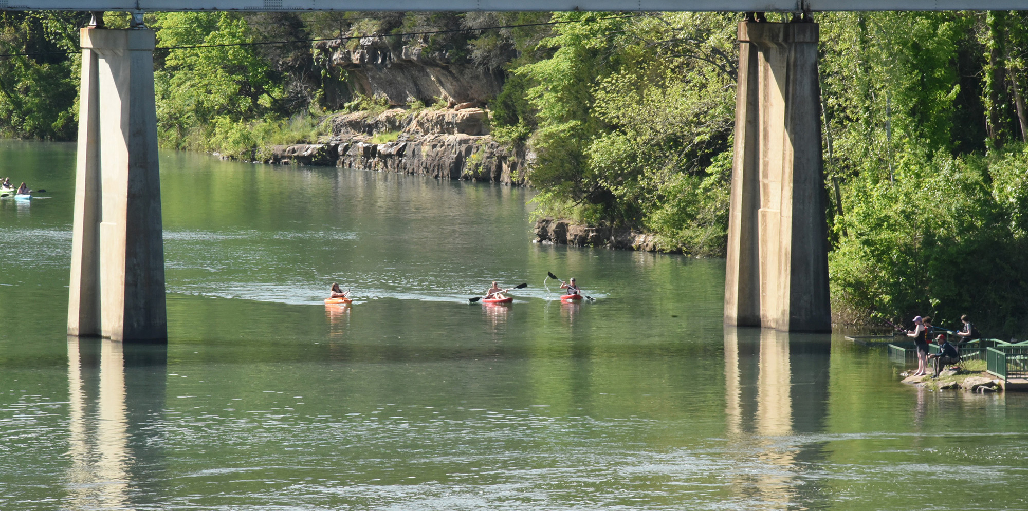
A swift channel just above Chicagoance Falls, Pukaskwa National Park. (Steve Howe)

The White River Paddling Route ends on Lake Superior (Steve Howe)
For deep-woods adventure, you can’t beat the 52 miles on the White River between White Lake Provincial Park and Lake Superior in Pukaskwa. There are 18 rapids on the stretch, from class II (easy) to class VI+ (fatal), each with a signed and mapped portage trail so you can skip any you choose. Most paddlers will walk at least half the drops, including the longest, a 1.4-mile mandatory portage around 100-foot Umbata Falls and its hydropower plant.
From White Lake Provincial Park, spend five days paddling through forested canyons and camping on granite ledges beside roaring rapids, before a four-mile lake paddle across Superior. Build in extra days in case winds or surf delay your lake travel.
Looking for more challenge? Run the longer, swifter and more remote Pukaskwa River (go in May or June). Fill any extra time fishing for “jack” (Northern pike), “pickerel” (walleye) and rainbow trout. For that you’ll need an Ontario Outdoors Card ($10CAD) and a separate fishing license ($21-$76 CAD; 800-387-7011; mnr.gov.on.ca/en ).
Map Crismar White River Wildwater; $13CAD; (905) 852-6151; chrismar.com
Permit Via Pukaskwa National Park; (807) 229-0801; pc.gc.ca
Guide & Gear Naturally Superior Adventures; naturallysuperior.com
Shuttle McCuaig Marine Services; $110CAD; (807) 229-0193; [email protected] Map & GPS data backpacker.com/hikes/1395748
Online Trip Planning Extras Get There Pukaskwa National Park lies on Highway 17 between airports at Sault Ste. Marie (250 miles south) and Thunder Bay (428 miles west). You can get supplies in the town of Marathon, 15 miles west of the park entrance.
Travel Contacts Ontario General tourism info: (800) 668-2746; ontariotravel.net
Thunder Bay (major airport city) >>Motel: Travelodge Airlane (Close to the airport, grocery stores, and Canadian Tire); (807) 473-1600 >>Transportation: Budget Rental Car (best prices our scout found); (807) 473-5040 >>Supplies: Canadian Tire (Fuel, kneepads, bug repellant, misc camping supplies, fishing licenses, tackle.);1221 Arthur Street West; (807) 475-4235 >>Groceries: Safeway; 1015 Dawson Rd;(800) 723-3929
Marathon (Pukaskwa National Park gateway) >>Supplies: Canadian Tire (fuel, bug repellant, miscellaneous camping supplies, fishing licenses, tackle), 3 Peninsula Rd (in the mall); (807) 229-2900 >>Groceries: D H Foods Ltd, 3 Peninsula Rd (in the mall); (807) 229-0641 >>Restaurant: Rumours Coffee House; 3 Peninsula Rd (in the mall, around back) (807) 229-8350
Popular on Backpacker
>", "path": "https://www.backpacker.com/gear/best-fathers-day-gifts-for-backpacking-dads/", "listing_type": "recirc", "location": "list", "title": "best father’s day gifts for backpacking dads"}}'> best father’s day gifts for backpacking dads, >", "path": "https://www.backpacker.com/gear/trekking-poles/best-trekking-poles/", "listing_type": "recirc", "location": "list", "title": "the best trekking poles for steep terrain and speedy missions"}}'> the best trekking poles for steep terrain and speedy missions, >", "path": "https://www.backpacker.com/stories/trail-qts-transgender-hikers-mentorship/", "listing_type": "recirc", "location": "list", "title": "lyla “sugar” harrod wants to see more trans hikers. so she became their mentor."}}'> lyla “sugar” harrod wants to see more trans hikers. so she became their mentor., >", "path": "https://www.backpacker.com/news-and-events/news/zion-national-park-to-ban-rvs/", "listing_type": "recirc", "location": "list", "title": "zion national park just announced a plan to ban rvs"}}'> zion national park just announced a plan to ban rvs.
Paddling Routes
Plan your lake superior adventure., lake superior paddling routes, planning starts here.
Find your paddling trip of a lifetime on the Great Lakes! Our big wilderness backyard in Northern Ontario features a wide range of sea kayak and canoe trips suitable for paddlers of all levels. Whether you’re looking for a day trip or a two-week wilderness expedition, you’ll find it in the backcountry of Lake Superior.Naturally Superior Adventures is pleased to share a range of sea kayak and canoe routes in the Lake Superior watershed with do-it-yourself adventurers. We’ve listed an overview of the route, distance, time required, season and relevant maps and guidebooks. If you’re looking for an expert guide and instructor, visit our guided trips website .
Contact us for inquiries about boat rentals and outfitting, or with your suggestions to update or expand our database.
Canoe Trips
Agawa river.
Difficulty : Intermediate Distance: 25-40 km Number of Days: 1-3 Season : Spring
Route Description
The Agawa River canoe route flows through Northern Ontario’s famous Agawa Canyon to Lake Superior. A treat for whitewater paddlers, this river has class I to IV rapids. The more challenging rapids have portages. Highlights of this trip include riding the historic Algoma Central Railway to the put-in, spectacular Agawa Falls and plentiful wildlife, especially bald eagles. There are a number of scenic campsites amid vestiges of an old grown white pine forest.
The Agawa is best paddled in May or during wet autumns. Whitewater boaters will enjoy a floodwater trip in April, however caution is required during periods of extreme high water. Put in at mile 114 (Canyon Station) on the ACR. For a longer, more whitewater intensive trip, start further upstream at Eton Station (mile 120). Take out at the Highway 17 bridge at Agawa Bay. *Note – As of January 2016, there is no longer passenger rail service to access the Agawa River. Contact us for possible alternative means of access.
Maps: National Topographic Series (1:50,000) 41 N/7 Water Levels: Use the water level gauge on the Batchawana River for reference. The Agawa should be runnable when the Batchawana level is greater than 2.5 metres. Expect very high water levels when the Batchawana level is greater than 3.25 metres.
The Agawa River is an ideal waterway to learn whitewater canoeing technique. Contact us for a custom trip.
Mijinemungshing Lake
Skill Level: Beginner Distance: 5-30 km Number of Days : 2-4 Season: Spring to Fall
Lake Superior Provincial Park’s Mijinemungshing Lake offers a diverse backcountry canoeing adventure. “Mijin” Lake’s 40 km of shoreline and dozens of islands makes it possible to spend a few days exploring. It’s also possible to portage into a number of other lakes from Mijinemungshing. Brook and lake trout fishing is excellent in this area.
Access Mijin Lake via highway 17 and Mijinemungshing Lake Road, located in the north end of Lake Superior Provincial Park.
Maps and Resources: National Topographic Series (1:50,000) 41 N/10&11 Visit the Lake Superior Provincial Park website to download a canoe route brochure . Mijinemungshing Lake is an excelling place to introduce your family to the joys of canoe camping. It’s also a sea kayak-friendly destination. Contact us for more information or a guided trip.
White River
Skill Level: Intermediate Distance: 80 km Number of Days: 5-7 Season: Anytime

Still, the White remains a solid choice for intermediate whitewater canoeists looking a river that can be run year-round. Beginning at White Lake Provincial Park (north of the town of White River on Highway 17), the river flows about 70 km to Lake Superior. From here, it’s a 10 km paddle to Pukaskwa National Park’s Visitor Centre at Hattie Cove.
Portages on the White River are challenging, and several otherwise runnable class II rapids end in large waterfalls. The mouth of the White River can be treacherous when onshore winds and swell intersect with river current, and the section on Lake Superior demands the respect of all paddlers.
Maps and Resources: National Topographic Series (1:50,000) 42 C/12, 42 D/9; “Top 50 Canoe Routes of Ontario” by Kevin Callan Canadian Canoe Routes online database
With hydroelectric development pending at several sites on the White River, you’re best to contact us for the latest route and information.
Skill Level: Advanced Distance: 37-65 km (river only) Number of Days: 3-7 Season: Spring
Route Description:
The Dog River is the most challenging whitewater trip on thenorth shore of Lake Superior. It’s a remote, wilderness river that falls in a series ofClass I to Class V rapids and spectacular falls, including awesome 40-metre-high(150-foot) Denison Falls, before emptying into Lake Superior, 25 km west of Michipicoten. This is a river trip for advanced paddlers only. Portages are virtually non-existent.Rapids are long and technical. Campsites are undeveloped. But for the skilled whitewater paddler, the Dog is a trip of a lifetime. It’s possible to access the lake-to-lake headwaters of the Dog at Hammer Lake, just north of Obatanga Provincial Park on Highway 17. From here, it’s about 65 km to Lake Superior. For a whitewater-only trip, put-in at the Dog River bridge on Paint Lake Road, off of Highway 17. Those familiar with the river have paddled from here to Lake Superior in 12 hours. Mere mortals are advised to plan on 3 to 4 days to afford the time to scout rapids and navigate portages. The 25 km section on Lake Superior takes 1 to 2 days to complete. Be prepared to be windbound on Superior.
Maps: National Topographic Series (1:50,000) 42 C/6 (headwaters), 42 C/3, 41 N/14, 41 N/15 (Lake Superior section) Water Levels: There is no water level gauge for the Dog River but the Pukaskwa gauge serves as a reasonable proxy. About 4.3 to 4.7 on the Pukaskwa gauge generally means medium flow on the Dog River. Contact us for a vehicle shuttle to the put-in on the Dog River.
Old Woman Lake
Skill Level: Beginner-Intermediate Distance: 25 km return Number of Days: 2-3 Season: Spring to Fall
Old Woman Lake proves the backcountry maxim that sheer beauty is only found through physical struggle. Old Woman Lake is a wilderness canoe tripper’s dream—a clear water gem cradled by the stalwart hills of the Canadian Shield. This portion of Lake Superior Provincial Park boasts abundant wildlife—moose, wolves and black bear—and exceptional trout fishing. Old Woman Lake is only accessible via a series of smaller bodies of water, linked by portages.
The lake is the ultimate destination for a wilderness base camp, and also offersaccess to the Sand River canoe route. In the spring, it’s best to launch at Mijinemungshing Lake, trace the scenic Mirimoki Wetlands and portage three times to get to Old Woman Lake. This route, however, becomes more difficult when water levels decrease in the summer. Later in the season, it’s best to start at Gamitagama Lake, a route that involves seven portages.
Maps and Resources: National Topographic Series (1:50,000) 41 N/10&11 “Top 50 Canoe Routes of Ontario” by Kevin Callan Visit the Lake Superior Provincial Park website to download a canoe route brochure .
Tired of the crowds of Algonquin, Killarney, Quetico or the Boundary Waters? Experience true wilderness canoeing on the Old Woman Lake canoe route in Lake Superior Provincial Park. Contact us for a custom trip.
Shikwamkwa River
Skill Level: Beginner-Intermediate Distance: 40 km Number of Days: 2-4 days Season: Spring to Fall
The Shikwamkwa River is a little known canoe route that exposes novice paddlers to the Northern Ontario wilderness. Starting from the railway ghost town of Dalton, east of Wawa, Ontario, the Shikwamkwa bisects the boreal forest. This is primarily a flatwater canoe trip, with three portages en route to bypass unrunnable logging dam, rapids and falls. A fourth portage near the end of the route accesses the Michipicoten River and the take-out at Highway 101. This route has good walleye and northern pike fishing. You’re all but guaranteed to have the waterway all to yourself.
It’s a long weekend run from Dalton to the Highway 101 bridge. For a four- to fiveday trip, consider extending the trip by descending the historic Michipicoten River to Lake Superior.
Maps: National Topographic Series (1:50,000): 42 C/1, 41 N/16
The Shikwamkwa River is an ideal waterway to learn wilderness canoe tripping techniques. It’s also a great wilderness canoeing destination for Scout groups and summer camps. Contact us for a custom trip.
Michipicoten River
Skill Level: Novice Distance: 15 km Number of Days: 1 Season: Spring to Fall
The Michipicoten River offers a pleasant day trip with lots of wildlife and historical appeal. Start at Scott Falls Dam and float downstream to Lake Superior. En route you may see black bear, bald eagles and salmon–especially in late summer. Historically, the Michipicoten was the main fur trade route from Lake Superior to James Bay. The remains of a Hudson Bay Company post can be found near the small community of Michipicoten River Village.
While this is a relatively benign trip, caution must be exercised in the fast moving water below Scott Falls. Be aware of sweepers–trees overhanging the water on the outside of river bends—and favour the inside of curves in the river. The mouth of the Michipicoten River can be hazardous when onshore wind and waves oppose the river current.
Naturally Superior Adventures offers a self-guided ecotour on the Michipicoten River that includes canoe rental, vehicle shuttle an eco-guide map.
Maps: NTS (1:50,000) 41 N/15
The Michipicoten River offers a great introduction to river canoeing for day-trippers. Check out Rock Island Lodge for adventure packages or contact us to register for a self-guided day trip.
Pukaskwa River
Skill Level: Advanced Distance: 65 km (river only) Number of Days: 5-7 (river only) Season: Spring
The Pukaskwa River cuts a tumultuous course through some of Ontario’s most remote wilderness. A treat for advanced whitewater canoeists, it features class I-IV rapids, scenic waterfalls and rugged portages. A highlight of the trip is Ringham’s Gorge, a 3-km-long whitewater canyon. Access the Pukaskwa River via Paint Lake Road (off of Highway 17, north of Wawa) and the Domtar 600 Road. From Wawa, it takes about 2 hours to reach the put-in.The upper reaches of the Pukaskwa are creek-like with lots of rugged, practically non-existent portages. The river is often obstructed by dangerous sweepers in this section. Open canoeists should plan on a grueling day-and-a-half of portaging and paddling (in that order) before reaching the hydro lines. From here, the river becomes wider and volume increases. The Pukaskwa is best run in medium to high water. At this level, many of the river’s57 rapids can be run. Still, there are a number of serious Class V rapids to be portaged, as well as several waterfalls. In extreme high water, be prepared to landupstream of traditional portages landings.Ringham’s Gorge is the Pukaskwa’s piece-de-resistance. If you choose to run it, be aware that there’s no turning back. The gorge is best run in medium water levels.The alternative is the arduous “Two Pants Portage”, which is 2.5 km long and takes the better part of a day to complete. From its mouth at Lake Superior, it’s a 90 km paddle north to Hattie Cove, or a 90 km paddle east to Michipicoten. Plan on a minimum of 4 days to complete this section, and be prepared to be windbound. Alternatively, boat shuttle pick-up can be arranged. Maps and Resources: NTS (1:50,000) 42 C/6, 42 C/5, 42 C/4 (river only); 41 N/13, 41 N/14, 41 N/15 (Lake Superior section east to Michipicoten); “Paddling the Pukaskwa River” by George Drought (out of print). Water Levels: The Pukaskwa River is best between 4.4 metres and 4.8 metres on the Water Levels gauge. The river becomes extremely pushy above 5 metres on the gauge. Take your wilderness canoe tripping to the next level with this spectacular whitewater expedition. Contact us for a vehicle shuttle to the put-in on the Pukaskwa River.
Sea Kayak Trips
Lake superior provincial park – michipicoten to old woman bay.
Level of Difficulty: Novice-Intermediate Distance: 25 km Number of Days: 1-3 Season: June-August
The northernmost coast of Lake Superior Provincial Park offers a diverse mixture of cliffs, headlands and cobblestone beaches. The trip’s highlight is paddling beneath the 200-metre-high (650 feet) cliffs at Old Woman Bay. Backcountry campsites are available at Smoky Point and Brule Harbour.
Maps: National Topographic Series (1:50,000) 41 N/15
Michipicoten to Old Woman is our favourite Weekend Getaway destination, the perfect guided sea kayak trip for first-time paddlers, families and outdoor adventure enthusiasts looking for a taste of the Lake Superior wilderness coastline.
Michipicoten Bay
Level of Difficulty: Novice Distance: 15 km Number of Days : 1 Season: Spring to Fall
The Michipicoten River and Lake Superior’’ Michipicoten Bay offer scenic sea kayak day trips. It’s a short paddle upstream on the Michipicoten River to the historic site of a Hudson Bay Company post and the cascades of Silver Falls. On Lake Superior, paddle along the sweeping expanse of Driftwood Beach to the rugged Greenstone Islands at the south end.
More adventurous day trippers may wish to cross to Michipicoten Light Station atPerkwakwia Point and explore the sheltered waters of Michipicoten Harbour.Return to the mouth of the Michipicoten River via the Glenn Gould Islets and Sandy Beach—the perfect spot for a picnic lunch.
The mouth of the Michipicoten River can be hazardous when onshore wind and waves intersect with the outflowing current. If in doubt, land on the adjacent beach and carry over to avoid paddling through the river mouth. Other hazards include exposure to wind and waves—be wary of onshore southwestly and westerly winds.
Maps: National Topographical Series (1:50,000) 41 N/15
Michipicoten Bay is our favourite location for sea kayak day trips . This guided trip ispopular with our Rock Island Lodge guests.
Denison Falls
Level of Difficulty: Novice-Intermediate Distance: 50 km Number of Days: 4-5 Season: June-August
This exceptional Lake Superior sea kayak trip includes a mixture of sand beaches and rocky headlands along a wonderful wilderness coastline. The highlight of the trip is spectacular Denison Falls on the Dog River, located a two-hour hike inland. Because of many landing options this trip is also suitable for open canoes.
Maps and Resources: National Topographic Series (1:50,000) 41 N/14, 41 N/15; “Teasing the Spirit” by Craig Zimmerman (out of print)
The Denison Falls Weekly Escape is a signature Naturally Superior Adventures guided sea kayak trip.
Neys Provincial Park
Level of Difficulty: Novice-Intermediate Distance: 5-30 km Number of Days: 1-4 Season: June-August
This often overlooked sea kayak destination on Lake Superior’s northernmost shore includes sand beaches, smooth rock island and the sweeping silhouette of Pic Island. Group of Seven landscape painter Lawren Harris revered the Pic Island area for its austere landforms. Novice paddlers can base camp at Neys Provincial Park campground while more experienced sea kayakers can circumnavigate Pic Island and camp on the east side of the Coldwell Peninsula.
While Neys’ Prisoner Cove campground seems benign, the open waters off of Pic Island can be treacherous. There are no rough-water landings on the south side of Pic Island so choose your days carefully. Expect plenty of fog in June and July. Backcountry campsites include King’s Beach (middle of Coldwell Peninsula) and Foster Island at the east end of the Coldwell Peninsula.
Maps: National Topographic Series (1:50,000) 42 D/10
Naturally Superior Adventures fully guided Rossport to Marathon trip paddles in the wake of Canada’s famous Group of Seven artists. This weeklong backcountry sea kayak trip visits painting locations in hidden coves, wave-washed beaches and the intriguing railroad ghost town of Jackfish.
Rossport Islands
Level of Difficulty: Novice-Intermediate Distance: 10-40 km Number of Days : 1-4 Season: June-August
The archipelago of islands off the quaint community of Rossport, Ontario, offers novice sea kayakers a friendly glimpse of Lake Superior’s north shore. The inner islands are protected from heavy seas and include a few great campsites on Healey, Channel and Wilson islands. A hiking trail on Quarry Island offers a panoptic view of the protected waters of the Lake Superior National Marine Conservation Area.
With the right conditions, more experienced paddlers can venture on overnight trips to the outer islands, visiting the lighthouse at Battle Island and the stunning cobblestone beaches of Wilson Island’s exposed south side. Despite its easy access, this region is noted for its cold water and frequent fog. Paddlers should be especially wary of southwest, south and southeast winds. Proper immersion gear, a VHF marine radio and a seaworthy kayak are essential. Note that mobile phones are reasonably reliable throughout the Rossport Islands (depending on your service provider).
Maps and Resources: National Topographic Series (1:50,000) 42 D/13, 42 D/14; “A Paddler’s Guide to the Lake Superior National Marine Conservation Area” by Darrell Makin and Zack Kruzins.
With a mix of sheltered and exposed water and numerous backcountry campsites, the Rossport Islands are a prime location for intermediate sea kayakers to explore.
Lake Superior Provincial Park – Old Woman Bay to Agawa Bay
Level of Difficulty: Intermediate Distance : 85 km Number of Days: 5-7 Season: June-August

This stretch of Lake Superior Provincial Park coastline comprises some of the most diverse sea kayaking on the Great Lakes. You’ll encounter towering cliffs at Old Woman Bay, sea caves at Cap Chaillon, sweeping sand beaches at Gargantua, and famed pictographs at Agawa Rock. Several imposing headlands with no rough-water landings make this trip best suited to experienced sea kayakers with appropriate skills and equipment, including cold-water gear and a VHF marine radio.
Maps: National Topographic Series (1:50,000) 41 N/15, 41 N/10&11, 41 N/7
The southern portion of this route parallels the Coastal Hiking Trail, offering paddlers the opportunity to stretch their legs and experience waterfalls, lookouts and coastal forests. Naturally Superior Adventures offers a five-day guided sea kayak trip of Lake Superior Provincial Park coastline for those looking for an all-inclusive adventure.
Michipicoten Island
Level of Difficulty: Intermediate-Advanced Distance: 70 km Number of Days : 4-6 Season: July and August
The exposed, fog-shrouded coastline of Michipicoten Island isthe most remote—and potentially hazardous—sea kayak destination on the Great Lakes. The island features abandoned fishing and mining communities and an enchanted mix of sand and cobblestone beaches. Undeveloped campsites are located at East Sand Bay, West Sand Bay, Green Island, Schaffer Bay, Quebec Rocks, Bonner Head (marginal) and Point Maurepas (marginal).
Contact us to arrange boat transportation to and from Michipicoten Island. Only expert sea kayakers with solid paddling and rescue skills, appropriate safety and communications gear, and a flexible schedule should attempt the 16 km (minimum) crossing to the island.
Maps and Resources: National Topographic Series (1:50,000) 41 N/12, 41 N/13; “An Introduction to Michipicoten Island” by David Whyte (out of print)
Michipicoten Island is a “bucket list” destination for Great Lakes sea kayakers. Naturally Superior Adventures offers a guided trip to the island: A minimally outfitted, self-supported expedition for experienced sea kayakers.
Pukaskwa National Park
Level of Difficulty: Intermediate-Advanced Distance: 90 km Number of Days: 5-7 Season: Anytime
Pukaskwa National Park is the premiere sea kayak destination on the Great Lakes. Its stunning scenery and sheer isolation ranks Pukaskwa amongst the best sea kayaking in Canada. This stretch of wilderness coastline includes spectacular campsites on sand and cobblestone beaches, cascading rivers and the potential to see wildlife such as moose, woodland caribou and bald eagle. Paddlers should have solid skills and appropriate equipment, including immersion wear and communication devices such as a VHF marine radio. Numerous stretches of this shoreline lack safe landings, including the mouth of the White River, approaching North Swallow River, and Otter Head.
This route is most frequently combined with the Lake Superior Highlands coast to make a 10-14 day sea kayak expedition. However, boat transfers are available to the remote south end of Pukaskwa National Park for paddlers with only a week’s vacation.
Maps and Resources: National Topographic Series (1:50,000) 42 D/9, 42 D/8, 42 D/1, 42 C/4; “Teasing the Spirit” by Craig Zimmerman (out of print); Pukaskwa National Park Coastal Paddling Trip Planner (Parks Canada)
Experience Lake Superior’s finest sea kayaking on Naturally Superior Adventures guided Pukaskwa trip .
Slate Islands
Level of Difficulty: Intermediate Distance: up to 80 km Number of Days: 4-6 Season: June-August
Northern Lake Superior’s Slate Islands offer something for everyone. Advanced sea kayaker’s will be challenged by the 10 km open water crossing to access the island (boat shuttles are also available—contact us for more information), while novices will appreciate the shelter of the inner harbour. Most paddlers are drawn to the Slates by the promise of encountering Ontario’s southernmost population of woodland caribou and to experience the islands’ bizarre geology, which attests to a meteorite impact. Lake trout fishing is exceptional in June and July.
The Slates consist of two larger islands—Mortimer and Patterson—arranged in a doughnut-shape and dozens of smaller ones within. Circumnavigating Mortimer is an easy day trip; paddling around Patterson requires a longer day or a relaxed overnight. Hazards include the open water crossing from Terrace Bay (or Jackfish) to the Slate Islands. It’s about 10 km long and is completely exposed to east, south and west winds. The south side of Patterson Island and the west side of Mortimer are also quite exposed.
Backcountry campsites are located at the northeast tip of Mortimer Island; the northwest tip (inside) of Patterson Island; Shell Cove (outer Patterson Island); Sunday Harbour (outer Patterson Island); Horace Cove (outer Patterson Island); and the Come-and-Rest cabin on McColl Island.
Maps and Resources: National Topographic Series (1:50,000) 42 D/10, 42 D/11; “A Paddler’s Guide to the Lake Superior National Marine Conservation Area” by Darrell Makin and Zack Kruzins
You’re all but guaranteed to see woodland caribou on Naturally Superior Adventures’ all-inclusive Slate Islands guided sea kayak trip, which includes transportation to and from the islands.
Gargantua Area
Level of Difficulty: Novice-Intermediate Distance: 5-40 km Number of Days: 2-4 Season: June-August
Sea kayak Lake Superior Provincial Park’s magical Cape Gargantua area. Launching from Gargantua Bay, visit the wreck of the Columbus, a century-old steamship sunk in the depths of Gargantua Harbour. Rounding Gargantua Point, the cliffs of Devil’s Warehouse Island loom above open water. From here, it’s a short 2 km paddle to the sandy campsites at Warp Bay.
Warp Bay makes an excellent base camp. Follow the Tugboat Channel to Nanaboozho’s Rock (Devil’s Chair) and cautiously round Cape Gargantua. Sheltered Indian Harbour has one nice campsite at the eastern edge of Cape Gargantua.
Lots of good landings make this trip accessible to novice/intermediate paddlers,however caution must be exercised rounding Gargantua Point and the northern tip of Cape Gargantua. There are no landings in these areas and shoals and sheer cliffs make for treacherous paddling in wind and waves. Hiking the Coastal Trail is a pleasant diversion if the lake is rough.
Maps: National Topographic Series (1:50,000) 41/N10&11
Haunted cliffs, mist-shrouded islands and sweeping sand beaches shape the magic of Gargantua. This area is suitable for families, base campers, sea kayakers and canoeists. You may also choose to sign up for Naturally Superior Adventures Spirit of Lake Superior Provincial Park trip , which will allow you to explore with a naturalist guide.
Lake Superior Highlands – Pukaskwa River to Michipicoten Bay
Level of Difficulty: Intermediate-Advanced Distance: 90 km Number of Days: 5-7 Season: June-August
Stretching west from Michipicoten, this section of Lake Superior coast offers superlative wilderness sea kayaking. Highlights include the sheer cliffs of Point Isacor and spectacular Denison Falls, a short hike up the Dog River. Campsites include a mix of sand beach and cobblestone. The coastline is entirely undeveloped, with the ramshackle remains of trappers’ cabins and abandoned fishing outposts tucked into a few bays.
This route’s greatest hazard is the eight-kilometre-long no-landing zone between Tamarack Bay and Ghost River. Paddlers are advised to monitor the weather with a VHF marine radio and to wear appropriate immersion gear, such as a wetsuit or dry suit.
Maps and Resources: National Topographic Series (1:50,000) 42 C/4, 41 N/13, 41 N/14, 41 N/15; “Teasing the Spirit” by Craig Zimmerman (out of print)
The Superior Highlands portion of Lake Superior’s Canadian shoreline is frequently ignored in favour of better-known sea kayak destinations. This means its backcountry campsites are pristine and crowd-free.
Hattie Cove to Michipicoten
Level of Difficulty: Intermediate-Advanced Distance: 180 km Number of Days: 8-14 Season: June-August

Lake Superior’s ultimate wilderness sea kayak trip traces the remote coast of Pukaskwa National Park and the Superior Highlands. While more ambitious paddlers may complete this trip in one week, it’s best to allot 10 to 14 days to enjoy the spectacular scenery. Cliffs, expansive sand beaches, stalwart headlands and cascading rivers make this a sea kayak trip of a lifetime.
Maps and Resources: National Topographic Series (1:50,000) 42 D/9, 42 D/8, 42 D/1, 42 C/4, 41 N/13, 41 N/14, 41 N/15; “Teasing the Spirit” by Craig Zimmerman (out of print); Pukaskwa National Park Coastal Paddling Trip Planner (Parks Canada)
Experience Lake Superior’s finest sea kayaking on Naturally Superior Adventures guided Pukaskwa trip .
Sibley to Rossport
Level of Difficulty : Intermediate-Advanced Distance: 125 km Number of Days: 6-8 Season: June-August
Between Lake Superior’s famed Sleeping Giant and the village of Rossport lie hundreds of wilderness islands, contained within the newly established Lake Superior National Marine Conservation Area. This island-to-island route explores a varied coastline of cobblestone and cliffs and will fascinate paddlers with its unique geology.
Starting from the village of Silver Islet, the trip begins with an eight-kilometre open water crossing to Porphyry Island. From here, open water crossings are the norm until you reach Roche Debout Point on the Black Bay Peninsula. The route crosses the Nipigon Strait at Fluor Island and follows the south shore of St. Ignace Island. A final crossing takes you to Battle Island and the Rossport group of islands. This trip is best for experienced paddlers. Hazards include rough landings and exposure to southerly seas. There are no sand beaches along this route so be prepared to land on cobble, boulders and smooth rock.
Campsites include: Finley Bay (Sibley Peninsula); Porphyry Island; Island No. 10 (the site of a heritage lighthouse); Spain Island; Jobin Island; Shesheeb Bay; Spar Island; Fluor Island (numerous); McNabb Harbour (St. Ignace Island); McKay Cove (Simpson Island); Harry Island; Sand Bay (west side of Wilson Island); and Channel Island.
Maps and Resources: National Topographic Series (1:50,000) 52 A/7, 52 A/8, 52 A/9, 42 D/12, 42 D/13, 42 D/14; “A Paddler’s Guide to the Lake Superior National Marine Conservation Area” by Darrell Makin and Zack Kruzins.
The Lake Superior National Marine Conservation Area is the world’s largest freshwater marine park and our guides’ second-favourite trip. If you’ve experienced the Pukaskwa Coast, you’ll marvel in the unique geology of Sibley to Rossport. Naturally Superior Adventures offers an all-inclusive guided trip .
White River Canoe Trip, Ontario, July 17-23, 2009
- White Lake Provincial Park
- Pukaskwa National Park
- Naturally Superior Adventures
View Slideshow
Modal title
First slide label.
Nulla vitae elit libero, a pharetra augue mollis interdum.
Second slide label
Lorem ipsum dolor sit amet, consectetur adipiscing elit.
From now until 4/30/24 purchase an Esprit Gift Card & SAVE 10%! Just enter promo code: SPRING10%

4-DAY PETAWAWA RIVER CANOE TRIP
Quick Details
- Hour Glass Duration: 4 Days
- Users Ages: Ages 12+
- Map Marker Location: Davidson, QC
Paddle the Petawawa River in Davidson, QC
Long considered a classic route for canoes, the Petawawa offers stunning scenery, deep gorges, the “Natch” campsite (the surrounding cliffs of which were the subject of a Tom Thomson painting) and frequent encounters with wildlife. The Petawawa cuts across the remote northeastern tip of the park and flows southeast towards its confluence with the Ottawa River.
Our four day, fully guided canoe trip will take us from Lake Traverse to McManus Lake. This stretch of river offers class 1-3 whitewater which provides ideal opportunities to develop your whitewater skills. Unparalleled for its wildlife and scenery, the Petawawa River provides the best of Algonquin wilderness with a fun, challenging whitewater experience.
The Petawawa Day Trip packs your day with the most whitewater possible! Due to the continuous nature of the river, we are able to make two descents for maximum enjoyment.
Day 1 – 7:00 am Breakfast – 7:45 am Meet your guides and fellow paddlers for a pre-trip briefing and packing – 9:00 am Depart for the river – 10:30 am Petawawa River – 12:15 pm Lunch – 1:00 Continue canoeing on the Petawawa – 4:00 Make camp at Little Thompson rapid – Evening Camp, dinner, relax
Day 2 – 8:00 am Breakfast – 9:00 am Break Camp – 10:00 am – 4:00 pm Canoeing from Little Thompson rapid to the Natch. Great whitewater instructional day! – 4:00 pm Make camp at the Natch – Evening Camp, dinner, relax
Day 3 – 8:00 am Breakfast – 9:00 am Break Camp – 10:00 am – 4:00 pm Canoeing from the Natch, through Schnooner and 5 mile rapids – 4:00 pm Make camp near Smith Lake – Evening Camp, dinner, relax
Day 4 – 8:00 am Breakfast – 9:00 am Break Camp – 9:30 am Paddle to take out on McManus Lake – 12:00 pm Lunch at take out & load equipment – 1:00 pm Drive back to Esprit (arrive mid-afternoon ~ 3:00 pm)
Note: Trip timing may vary depending on water levels.
What’s Included
- 4 days of canoeing
- 1 night camping at Esprit’s lodge
- 3 night camping on the river
- 4 breakfasts, 4 riverside lunches, 3 dinner
- All safety and paddling equipment
- Internationally certified guides
- Local transportation
- Complimentary après canoeing beverage
What to Bring
All your mandatory safety equipment is provided for you, therefore, all you need to bring with you are some personal items to help make your day even more enjoyable. We recommend that you bring a pair of shoes or sandals to wear on the river (they will get wet!), your swimsuit and/or shorts, sunscreen, water bottle, towel and a change of clothes.
If you are joining us during the early spring (April & May), we highly recommend that you bring an extra fleece or wool sweater, fleece socks and running shoes (versus sandals) for extra thermal layering under your wetsuit.
ADDITIONAL ADD-ONS
Customize your experience with Esprit by adding any of the following options:
RELATED RIVER TRIPS
- Most Popular
- Calendar May-Oct.
- Map Marker Davidson, QC
- Users Ages 7+
- Hour Glass 8 Hours
Ottawa River Rafting Day Trip
Raft both channels of the Ottawa River, Canada’s most famous whitewater river! The best way to experience the Canadian wilderness and enjoying exhilarating high volume rapids.
- Calendar June-Oct.
- Hour Glass 4 Days
4-Day Coulonge River Trip
Join us for 4 days unforgettable paddle on the Coulonge River from Rapids Enrage to the Les Chutes Coulonge and experience amazing waterfalls rock studded rapids! Choose between a two day or four day trip.
- Calendar Jul.-Aug.
4 Day La Riviére Noire Trip
Enjoy a Western Quebec’s best canoeing experience with an overnight paddle adventure on the Noire River. Book your trip online to experience the beautiful scenery!
Disclaimer: As with any information obtained from the Internet, this information must not be solely relied on without adequate investigation and verification of the journey by the user. The author and other persons identified in this web site will not be held liable for any damage to any person or property resulting from the use of this information. The author acknowledges the references for this information including map resources supplied by the Ontario Ministry of Natural Resources and Parks Canada. The following 1:50,000 scale topographical maps required for this trip are available from Ontario Ministry of Natural Resources (see address below): Pokei Lake 42C/6 White River 42C/11 Cedar Lake 42C/12 and Marathon 42D/9. For the White River Canoe Route guide and map (ISBN 0-7729-6814-4) and current river and portage conditions write the Ontario Ministry of Natural Resources at P.O. Box 1160, Wawa, Ontario P0S 1K0 or phone (705) 856-2396. Appropriate caution must be taken by paddlers, using suitable skills and equipment, because not all portages and rapids or their classes are marked on this map or the topographical maps. Natural Resources no longer clears the portage trails. For more information on Pukaskwa National Park phone the Pukaskwa National Park Service at (807) 229-0801. Overall, the majority of the White River's rapids are Class 2 and higher; the lower third of the river is primarily waterfalls requiring portaging. Starting from the White Lake Provincial Park it is a 4-to-5 day 112 kilometer trip to Lake Superior. Starting from Negwazu Lake it is a 7-to-8 day 192 kilometer trip. The White River can be run anytime during the ice-free season. Campsites can be almost every 8 km along the river and on the lakes, although the number of established campsites is low because the White River is not an overcrowded canoe route. There are few good campsites from 6km upstream of the confluence of the White River and the Oskabakuta River down to the bridge below Umbata Falls so parties may travel further in one day than originally planned providing extra time along the lower part of the river where crowding may occur. During busier periods in the summer campsites may not be available along the White River near Chigamiwinigum Falls due to the intersection of the Coastal Hiking Trail with the White River Canoe Route. Park officials recommend canoeists use any of the 2 campsites on River Left above the Third Falls (P95 River Right) or the 2 campsites on River Left between the Third and Second Falls (P215 River Left); there are also 3 campsites accessible only by water downstream from Chigamiwinigum Falls (300 meters River Right opposite the end of the Chigamiwinigum Portage, 3.2km River Right and 3.5km River Left before the mouth of the White River) which are generally less used than those below the falls. Filter or boil the river water to reduce the possibility of Beaver fever (Giardia Lamblia, protozoa that infects the intestinal tract of humans and other mammals). We stored our food in large plastic canoe-tripping barrels and had no problems with bears at any of the campsites. MNR recommends hanging your food from the trees. This page has been on the WWW since February 20, 1997! Use this URL to link to the White River 1996 Canoe Trip Page: www.wilds.mb.ca/whiteriver Return to Canoeing A WHITE River Return to Wilds Of Manitoba Wilderness Trips Page Paddle Manitoba Resource Page www.paddle.mb.ca WILDS of Manitoba www.wilds.mb.ca Copyright © 1997 WILDS of Manitoba
- Tales from the Cripps
- Accessories
- Inflatables
- Touring/Recreation Kayaks
- Whitewater Kayaks
- Sweepstakes
- Photo Contest
- Caption Contest
- Paddling Shops Directory
- Paddling Outfitters Directory
- Paddling Life Store
- Paddling Life — Digital Media Kit
- Paddling Life Staff Bios
- Schwag & Books
- Discount Paddling Trips.
Charlie Walbridge Releases “Whitewater Rescues: True Stories of Survival, Bravery, and Quick Thinking”
Paving the way: chattooga celebrates 50 wild & scenic years (special aw tribute), rig like a pro with down river equipment, fish on a review of sotar’s strike 13’6″ fishing raft, kayaking the zion narrows, bren orton update: body of pro kayaker found in switzerland’s lake maggiore, bridging memories: reflections from the 1,300-mile, 52-day columbia river canoe project, new book: “borne by the river” details canoeing the delaware from headwaters to home (plus: a pl q /a with author rick van noy), a doozy of a race: african dusi marathon brings out long-running marathoners, with women at the forefront, covet corner: new gear from nrs, put this on your bucket paddling list: death valley, hala pits its boards against cowboys in marketing campaign, a weekend with isle: testing the latest sups, hybrids and more in mission bay, mcbride, mcbeath come to hobie as sales and marketing heads, jackson kayak buys werner paddles, sea kayaking the northern tier of the san juans, sea kayaking, whitewater, climbing, suffering and love: check out new erik boomer baffin vid, tales from the cripps: episode 23 – paying it forward with andrey coto robles, tales from the cripps: episode 21: getting brown with dave fusilli, listen to armchair explorer’s podcast with “amazon woman” darcy gaechter, wilderness systems launches new iatak 110 inflatable fishing kayak, paddlesports trade coalition announces colab event in okla. city sept. 3-6.
- Kayak Fishing
- Digital Media Kit
- Destinations
- Discount Paddling Trips
- Eugene Buchanan – Author
Kevin Callan’s Top 50 Canoe Trips of Canada
Looking for the best canoe trips in Canada?

Here are the 50 best canoe trips of Ontario as chosen by one of Canada’s most famous paddlers. Bring your hockey stick and Kokanee…
Kevin Callan is the author of thirteen books, including the best selling “The Happy Camper”, the incredibly popular series of paddling guides, and most reviewed “Wilderness Pleasures: A Practical Guide to Camping Bliss”. On a regular basis, he presents across North America and has been a key speaker at all the major canoe events for over 25 years.
It’s no surprise that Kevin Callan lives in Peterborough, Ontario, deep in the heart of canoe country and home to the Canadian Canoe Museum. He has written 12 other books on canoe trips in Ontario, and this new book will be welcomed by his many readers, especially novice canoeists.
Some of these canoe trips are well known, and others are hidden secrets. Callan gives all the information paddlers need to complete each route, from detailed descriptions and maps of all access points to accurate portage lengths and important river features, as well as general advice on everything from running rapids to shuttle arrangements – all embellished with historical notes and his trademark humor.
Ranging from two-day paddles to week-long expeditions, Top 50 Canoe Routes of Ontario includes 40 routes taken from Callan’s Paddler’s Guides series, including: Turtle River, White River, Nellie Lake Loop, Eighteen-Mile Island Loop, Old Voyageur Channel, Big Trout Loop, Nipissing River, Barron Canyon, Leopold’s North Country Loop, The Pines Loop, Sturgeon Lake/Olifaunt Lake, Wabakimi Provincial Park, Bark Lake Loop, York River
The book also includes 10 new routes that Callan has yet to share with his readers. They include: Elliot Lake Blue Lake Loop, Lake Superior Provincial Park’s Old Woman Lake, Spanish River, Biscotasing Lake Loop, Island Lake, Upper Ottawa River, Algonquin’s South Panhandle
Beta 336 pages, 7 1/2″ X 9″ 50 maps, color throughout EAN: 9781554078349 ISBN: [ 1554078342 ] paperback 29.95 CDN / 29.95 US
Available on Amazon

LEAVE A REPLY Cancel reply
Save my name, email, and website in this browser for the next time I comment.
Newsletter Sign Up
Win swag by joining the pl newsletter, latest news, bad ash outdoors on a mission about fishin’, paddle sports show hits france sept. 24-26 (with new film fest—enter to win), rio’s lodge pacuare – costa rica, op-ed: the problems with kayak cross , dagger’s all-in with its new indra ww kayak, you might also like related recommended to you, editor picks, rafting community loses a legend with the passing of rafael gallo, largest sup accident in the world 4 dead in wales, conflicting reports: helmet-makers chime in on recent virginia tech helmet study.
- Paddling Life Exclusives 1656
- Paddling Industry News 1160
- Archive 859
- Sea Kayaking 768
- Whitewater Rafting 694
- Whitewater Kayaking 675
- Destinations 405
- Canoeing 359
Founded by a team of industry veterans and reaching everyone from first-timers to seasoned pros, Paddling Life keeps its fingers on the sport's pulse through timely news coverage, event updates, profiles, gear reviews, video links, photo galleries, story links and more. Our goal: to support and grow paddlesports and keep the sport's stoke alive.
Contact us: [email protected]
© Copyright - Paddling Life
Anglers White River Resort
White River Resort and Restaurant 870-585-2226 Creek Resort and Campground 870-585-2231
Float Trips
Float trips on the white river.

Anglers White River Resort is located directly on the banks of the White River near Mountain View, Arkansas, at the point where Sylamore Creek flows into the White River. That makes Anglers the perfect jumping off point for floating the White River and for trout and even small and large mouth bass fishing.
Cool Water – Gentle Float
Our section of the White River is full of clear, cool water (it feels great on a warm Arkansas summer day!) and the gently moving water makes it an easy float for the entire family. We have canoes and kayaks for rent or you can take the whole family in one of our large yet easy to manage inflatable rafts. Better yet, rent a combination of boats and let everyone take turns in the canoes and kayaks!
Supplies & Shuttles

We’ll do all the “heavy lifting” for you! We have all the boats and equipment available to rent and our store has all the picnic supplies you will need. We’ll transport you up river to put in for either an 8 mile or 17 mile float down the White River. At the end of the float trip you arrive at our easy access grass lawn and you are right back at Anglers White River Resort with your car, room, cabin or campsite nearby.
Canoes, Kayaks & Raft – *Rental Rates
All of our canoe/raft trips include jackets and paddles.
*Based on double occupancy
Have Questions? Email Us!
Your Name (required)
Your Phone (required)
Your Email (required)
What Are You Interested In?
What Kind Of Fun Are You Looking For?

Charming, Friendly Vacation Spot
My family had two rooms here on a weekend, when most other places were booked. We were delighted with the clean, neat room and porch overlooking the White River and with the restaurant. It was a quiet, family-friendly place. Even if you aren’t specifically visiting the White River, you will find plenty to do in the area. I hope to return.
Great fishing trip
“Guided White river fishing charter out of Anglers resort in Allison, Ar was outstanding. River was high and muddy but our exceptional guide Drew took us to a spring fed side creek and we caught fish! A beautiful day, excellent fishing with a fantastic guide. If you’re in the area we highly recommend a fishing trip with Drew out of Anglers resort!”
Great Cabin on the River
My son and I booked a “fishing special” guided trout fishing trip on White River and three nights in a river front cabin and meals included. Fantastic People run this place from the front desk to the fishing guide Jim, everyone wanted us to have a relaxing time at the resort. We took a side trip to nearby Blanchard Springs Caverns. We went down town Mountain View and joined the crowd around the Square for some great live country / folk music. My wife and Labrador “MAXX” joined us and the folks at the resort treated us like family. We booked a full day fishing trip for rainbow trout and we limited out with ten fish by10:30 in the morning. We saw Three mature bald eagles a river otter , deer and a road runner the bird not the car.
Amazing Mother’s Day Weekend
Lovely people that work here….Super friendly,amazing service all the way around….From the Ladies at the front desk to our servers at the Restaurant….My dinner was so tasty,i had the Catfish plate and my Daughter had Chicken Alfredo……The next morning for Mother’s Day, We ate the breakfast buffet (yum)….The room with a view was so beautiful with the backdrop of the White River ….The Room we had was very nice & clean,had the Rustic look to it,We loved it….Enjoyed the walk out upper deck from our Room,with the amazing view….I highly recommend it….Thx From Memphis TN.
- White River Cabins
- Sylamore Creek Cabins
- Motel Rooms
- Guided Fishing
- Boat Rentals
- Mountain View
23080 AR-5 Allison, AR 72050
(870) 585-2226

Explore Magazine
Hiking, Camping, Paddling, Cycling, Adventure — Canada's best source for Inspiring Outdoor Experiences.
25 Incredible Ontario Canoe Routes You Need to Paddle

Michaela Ludwig
July 25, 2021

There’s no place in Canada that’s as canoe-crazy as Ontario, and it’s easy to see why.
To start, the province is home to more than a quarter-million lakes. That accounts for one-fifth of the world’s fresh water. You could say that life in Ontario is lived at the lake’s edge. But it’s not just lakes; navigable rivers and tributaries are found in abundance too.
Canoeing in Ontario is what poutine is to Quebec, and Moraine Lake is to Alberta: iconic . The province’s waterways are steeped with Canadian heritage. First Nations were the first to identify that rivers like the Mattawa and French were effectively ‘water trails’, and they used them as important early routes. Later, Voyageurs (fur traders) would do the same. It’s a history that Canadian school children all learn, and there are few things that feel as Canadian as canoeing a heritage river in Ontario.
Today, canoeing is a recreational pursuit, but the raw wilderness afforded by backcountry paddling still invigorates spirited adventure. Here are 25 Ontario routes to inspire your next quintessentially Ontario canoe trip.
Routes suggested by Explore editor David Webb.
1. Beaverhouse Ranger Station
Quetico provincial park.
Region : Atikokan
Put in : Start at the northeast corner of Beaverhouse Lake.
Take out : This is a loop and you’ll come back to Beaverhouse Lake.
Distance : 64 kilometres
Difficulty : Easy
Description : Known also as the Cirrus Lake – The Sue Falls Loop , this paddle should take you about four days. The route travels across five lakes with seven portages. You’ll enjoy long, uninterrupted stretches of paddling, with portages few and far-between. While paddling close to the north shore of Quetico Lake, look for the Anishinabe rock paintings (pictographs) on the granite cliffs.
URL : ontarioparks.com/park/quetico/activities
2. Falls Chain Loop
Put in : Start at Cache Bay.
Put out : This is a loop route, so you’ll journey back to your put-in point.
Distance : 168 kilometres
Difficulty : Difficult
Description : It should take 8-10 days to complete this trip. This should be reserved for strong, experienced paddlers. You’ll paddle through 26 lakes and cross 37 portages. Stop at Silver Falls, follow smaller lakes and streams and paddle alongside the American border.
3. Lady Evelyn River
Lady evelyn smoothwater provincial park.
Region : Timiskaming
Put in : If paddling the north branch, you can access the entry at Gamble Lake. If you plan to paddle the south branch, you’ll need a floatplane to take you to Florence Lake.
Put out : Access off the river is either via floatplane or by paddling through several lakes to the access at Mowat Landing.
Distance : About five to seven days, depending on the route you decide to take.
Description : This is a wilderness river, known to have some awesome early-season whitewater. The north branch is easier to access at the beginning, and can be done by vehicle. This route is shorter and passes by three large waterfalls. The north and south branches will meet during your trip, and then the river begins to drop in elevation, and steeply, with rapids and falls and rugged portages. The river will then split again after paddling through Katherine Lake, once known as Divide Lake. Either way you choose, your course will be scenic, rugged and natural.
URL : ontarioparks.com/park/ladyevelynsmoothwater/activities & smoothwater.com

4. Lake Temagami/Obabika Lake Loop
Finlayson point provincial park.
Region : Temagami
Put in : Launch your canoe or kayak in Lake Temagami.
Put out : This route is a loop and will bring you back to Lake Temagami
Distance : 88 kilometres
Description : This trip will take you at least five days and four portages. Starting at Lake Temagami, you’ll paddle to the North Arm. You’ll paddle through Sharp Rock Inlet, Diamond Lake, Wakimika Lake and river and then into Obabika Lake and through Obabika Inlet. Once you’ve paddled through the inlet, you’ll come back to Lake Temagami. Be prepared for strong headwinds, which can create big waves.
URL : ontarioparks.com/park/finlaysonpoint/activities & myccr.com/canoedb
5. Sturgeon River/Wawiagama Lake
Sturgeon river provincial park.
Put in : You can put in at Paul Lake, via floatplane, or further north along river where the Portelance timber access road crosses.
Put out : You can get a floatplane out of Wawiagama Lake, or by vehicle at the Goulard Lumber Road.
Distance : It depends on the route you choose, but it should take about a week to complete.
Description : There are several options when paddling the Sturgeon River, but the most popular route includes the length of the river, and then paddling upstream on the Obabika River and onto Wawiagama Lake. A scattering of portages and some class I and II rapids lead to campgrounds along the way. This trip can be combined with other routes to make it a longer voyage.
URL : ontarioparks.com/park/sturgeonriver/activities
6. Maple Mountain Route
Obabika river provincial park.
Put in : Take Highway 558 to Mowat Landing to launch.
Put out : This is a loop route, so you’ll end up back at Mowat Landing.
Distance : 114 kilometres
Description : This route is not for the novice, nor the faint-of-heart. The trip should take about six days and includes 16 portages. The Montreal River, Lady Evelyn River, Lady Evelyn Lake, Sucker Gut Lake, Hobart Lake, Bill Lake – these are just a few of the waterways you’ll have to navigate on your journey. Start your journey on a Monday to avoid weekend traffic. Be sure to hike up Maple Mountain before paddling home again.
URL : myccr.com/canoedb
7. Kopka River
Wabakimi provincial park.
Region : Thunder Bay
Put in : The Via Rail stop at Allanwater Bridge (you can arrive by train from Toronto)
Put out : Paddle from Wigwasan Lake to the take-out point at the end of Bukeniga Lake Access Road. This is about 30 kilometres from Armstrong Station, a small community on Highway 527 from Thunder Bay, and a Via Rail stop.
Distance : 225 kilometres
Description : This incredible excursion will take almost two weeks to complete, depending on the weather. If you start at Allanwater Bridge, you’ll head upriver on the Brightsand and then on the Kashishibog River. This part should take about five days. Portage to Redsand Lake and then dip into the headwaters of the Kopka River. You’ll spend another five days paddling down the Kopka, and you’ll be rewarded with one of the most spectacular paddles northern Ontario has to offer.
URL : albinger.me/tag/kopka-river-canoe-route
8. Ogoki River
Put out : Albany River, and have a pre-arranged ride back to your vehicle.
Distance : 460 kilometres
Description : This epic 14-day voyage is not a loop trip, so some pre-planning is required to make sure you can get back to your vehicle. You’ll cross 20 portages on this two-week journey, the longest being about 300 metres. The fishing is said to be fantastic, and if you’re lucky you’ll see a lot of wildlife.
9. Marie Louise Lake
Sleeping giant provincial park.
Put in & Put out : You’ll paddle around Marie Louise Lake, entering and exiting the water from the boat launch.
Distance : 10 kilometres
Difficulty : Intermediate
Description : This is an excellent option for those that want to paddle, but might want a few good breaks here and there. You can camp at the Marie Louise Lake campground and put in and out of the lake at your leisure. Canoes and kayaks are available for rent from the park store.
URL : ontarioparks.com/park/sleepinggiant/activities
10. Charlton-Three Narrows-Iroquois Bay-Whitefish Falls Loop
Killarney provincial park.
Region : Killarney
Put in : Widgawa Lodge.
Put out : This is a loop trip, so you’ll end up back at the lodge to unload.
Distance : 75 kilometres
Difficulty : Moderate
Description : This trip should take about seven days. There are plenty of places to camp on Crown land along the way. This seems to be a route that’s less popular, so you might not run into as many people on this loop. There are about 20 portages, with the longest being 1,200 metres. As some of the route passes through Whitefish River First Nation land, it is advised to obtain permission from the band office before crossing.

11. Bell Lake-David Lake
Put in & Put out : This is a loop trip. You’ll start and end at Bell Lake.
Distance : 24 kilometres
Description : This trip should take about two days to complete, which makes it a great option for a weekend paddle. You’ll pass through some of the most beautiful lakes in the park, and you’ll also get the chance to see white quartzite hills from David Lake. There are four portages, but they are relatively easy. The longest portage is 745 metres. Reserve a camping spot as early as possible, if you want to go during the peak summer period, and be sure to take in some hikes along the route.
12. Mississauga River
Kawartha highlands provincial park.
Region : Bancroft
Put in : Take Highway 36 north and then Highway 507. Turn right on Mississauga Dam Road and make another right at the stop sign. You can access the river from Iron Bridge.
Put out : Leave your other vehicle on Highway 36 where the river enters Lower Buckhorn Lake.
Distance : 21 kilometres
Description : Although this journey is not a loop trip, it is another great option for a weekend away. It will include 15 portages, the longest of which is only 360 metres. There is cellphone service along the river. Aluminum canoes or kayaks are recommended for tackling this trip. You’ll encounter several rapids and a few short, scenic waterfalls along the way. The trip could be done in one day if you ‘re keen.
13. French River Canoe Route
French river provincial park.

Region : Killareny
Put in : Pine Cove, at the end of Highway 528A.
Put out : This is a loop route, so you’ll end at Pine Cove.
Distance : 20 kilometres
Description : This trip takes about four days to complete, but it can be customized if you want to do the journey in less time (there are 13 access points along the river). You’ll find rapids, minimal portages and beautiful scenery as you paddle the historic route of First Nations groups and explorers. This trip is perfect for the intermediate paddler that is looking to improve their skills.
URL : trailpeak.com/trail-French-River-Canoe-Route-near-Sudbury
14. Restoule-Upper French River Route
Restoule provincial park.
Region : North Bay
Put in : Launch your canoe on Restoule Lake, about 75 kilometres southwest of North Bay on Highway 534.
Put out : This is a loop trip, so you’ll end up back at Restoule Lake.
Distance : 72 kilomteres
Description : You’ll spend about five days on this trip and trek over 14 portages, the longest of which is about 900 metres. There is beautiful scenery, and you’ll be paddling a route with history – Champlain and the Voyageurs navigated one of the same portages you’ll venture through. With lots of wildlife to be seen and plenty of fishing to be done, this promises to be a great trip.

15. Petawawa River
Algonquin provincial park.
Region : Algonquin
Put in : Lake Travers
Put out : Lake McManus
Distance : 2-4 days
Description : This is the trip of a lifetime for the whitewater canoeist. You won’t find a more exhilarating trip, full of wildlife, stunning scenery and stories to last a lifetime. Most canoeists leave about four days for the trip. Those that are comfortable with the route might accomplish the trip in three days, or even two.
URL : loonislandoutdoors.com
16. Rain Lake
Put in : Launch your canoe on Rain Lake, at access point #4.
Put out : This isn’t exactly a loop trip, but more like a there-and-back trip. You’ll make it to Moccasin Lake and then come back again.
Distance : 30 kilometres
Description : This is a great introduction to wilderness canoeing. There’s quite a bit of lake travel, easy portages and the opportunity for a side trip. Head to Moccasin’s North Arm if you’re interested in some optional river travel.

17. Meanest Link
Put in : You’ll put in at Oxtongue Lake.
Put out : This is a loop trip (albeit, a long one) and you’ll end up back at Oxtongue Lake.
Distance : 68 kilometres
Difficulty : Difficult (they don’t call it The Meanest Link for nothing!)
Description : Twenty days, 93 portages and the meanest trip you’ll take in a canoe. This route combines four smaller routes – Oxtongue to Huntsville, Huntsville to Brent, Brent to Openongo and Openongo back to Oxtongue. Named after Algonquin Outfitter’s Bill Swift Sr., this route is a combination of four difficult canoe routes that connects the four stores in Algonquin Park.
URL : algonquinoutfitters.com/meanest-link
18. Georgian Bay Coast
Region : Bruce Peninsula
Put in : Tobermory’s Little Tub Harbour.
Put out : If you choose to paddle the length of the bay, you would end near Owen Sound.
Distance : 237 kilometres
Difficulty : Moderate to difficult
Description : Tobermory to Owen Sound is the entire coast, but you can make this trip as long or as short as you want. View lighthouses at day and at night, explore inlets and coves, and discover abandoned fishing villages. This isn’t a loop, unless you turn around and paddle back where you came from, so plan accordingly.
URL : thorncrestoutfitters.com/paddling
19. Kingston Islands
Thousand islands national park.
Region : Gananoque
Put in : Cataraqui Canoe Club’s public boat launch, just off Rideau Street.
Put out : Make your way back to your starting point to unload.
Distance : 3.5 kilometres from the club to Cedar Island, and another 5 kilometres between Cedar and Milton Island
Description : Located on the eastern end of Lake Ontario, you’ll paddle around the Kingston Islands, Cedar and Milton. This trip should take a full day. You can get to the beaches on Wolfe Island, when the winds are light.
URL : frontenacarchbiosphere.ca/explore
20. Superior Shore
Pukwaska national park.
Region : Marathon
Put in : Hattie Cove Visitor Centre
Put out : Michipicoten Bay, near Wawa
Distance : 160 kilometres
Description : Lake Superior is known for being large, wild and cold. And you’re going to paddle its coast! Be prepared for rough weather, tempered by some of the most rugged and untamed scenery that you’ll never be able to find anywhere else. Camp within the park, and then on Crown land once you’re past Pukaskwa River and heading south to Michipicoten.
URL : pc.gc.ca/eng/pukaskwa (download the trip planner PDF)
21. Missinaibi River
Northern ontario.
Region : Algoma
Put in : Near the town of Mattice
Put out : Near the town of Moosonee
Distance : 297 kilometres
Description : On the Missinaibi River , you’ll undergo 7 portages during this long trip, the longest being about 2,530 metres. It’ll take about two weeks to complete the journey, and it’s certainly not for the faint of heart. Black Feather Rapids, Kettle Falls, the rapids around Alice Island, Thunderhouse Falls, Hell’s Gate Canyon – all of this and more awaits!

22. Algoma’s Ranger Lake Loop
Put in : Start on Ranger Lake, Saymo Lake or Gong Lake.
Put out : This is a loop route, so you’ll reverse course and come back to your starting point.
Distance: 104 kilometres
Description : Nine days, 37 portages and one amazing canoe trip! Bring your camping gear for the numerous campsites along the way, and don’t forget to pack your fishing gear – brook and lake trout are available in abundance. You’ll pass through Ranger, Saymo and Gong Lakes, West Aubinadong River, Megisan, Prairie Grass Lakes and Nushatogaini River on this loop.
23. Goulais River
Put in : You’ll start your trip at Witchdoctor Lake.
Put out : Whitman Dam Falls, with a short walk up to Whitman Dam Road.
Distance : 70 kilometres
Description : There are a few different options for take-out points along the way, so this trip could be done as a five-day stretch, or you can do it as an overnight or even a day paddle. You’ll find waterfalls, rapids and great scenery along this route.
URL : myccr.com/canoeroutes
24. Batchawana River
Batchawana river provincial park.
Put in : You’ll start on the river at the Batchawana Station, on the Algoma Central Railway, about 128 kilometres north of Sault Ste. Marie.
Put out : Highway 17, at the mouth of the Batchawana River.
Distance : 48 kilometres
Description : This trip should be done in May and early June, when the water levels are high enough. It takes about 4 days. You’ll find the water moves quite swiftly, passing through some spectacular Algoma country along the way. There are good camping locations along the river.
25. Lower Madawaska
Ottawa area.
Region : Ottawa
Put in : Aumond’s Bay, near Quadeville
Put out : Griffith at Highway 41
Distance : 40 kilometres
Difficulty : Easy to moderate, depending on time of year.
Description : Nicknamed “The Mad,” this river isn’t as bad as the name might suggest. This is known as a paddler’s playground for the long, flatwater paddle to the first rapid. In the spring, the river attracts higher-calibre kayakers, but in the summer, when the water’s level is lower and the speed is slower, this is a great trip for beginner paddlers or families. The Lower Mad is known to be a great learning river. The entire route can be done in two or three days, or you can exit at Buck Bay and make it a one-day trip.
URL : ottawavalley.travel/docs/paddleroutes
Gear Roundup
Canoe and kayak journeys like these require specialized gear and apparel. Here are a few of our preferred picks:
- Mustang Survival Highwater 60L Waterproof Gear Hauler
- Mustang Survival Khimera Dual Flotation PFD
- Mustang Survival Callan Waterproof Jacket

P.S. Want more adventure in your life?
Join over 1,000 subscribers across North America when you sign up for explore magazine’s “Live the Adventure” Club.
Click here to learn more.
More Ontario Adventure on Explore
When you purchase something via the links in our articles, we may earn a small affiliate commission. Read more about our policy .
E-BOOK TODAY!

READ MORE: Hiking Trail Reviews , Trails , Travel

LEAVE A COMMENT Cancel reply
Recommended for you.

Adventure , Hiking , Travel
Explore the Beauty of Northern Wyoming: Top 5 Places to Visit on Your Road Trip Adventure
Buckle up for a road trip through northern Wyoming, a region often overlooked but packed with world-class natural wonders.

Climbing , Partner Content , Travel
In the High Alpine, You Need to Trust Your Team—And Your Gear
Read this inspirational story of three female athletes going on a high alpine climb in the Swiss Alps.

Editors’ Picks , News , Travel
13 Must-Read Adventure Books for Your Outdoor Bookshelf
There are 13 provinces and territories; here are 13 adventure books with one set in each.

Partner Content , Travel
Madrid: Come for the Tapas, Stay for the Hiking, Cycling and Epic Adventures
A trip to Madrid is often booked with an appetite—for rich experiences and tapas.

Adventure , Trails , Travel
The Kiwi Who Has Run a Marathon a Day Across Canada for Cancer
How does it feel to run the entire length of the second-largest country in the world?

3 Quick Jaunts from Madrid
Looking for a cool outdoorsy experience near Madrid, Spain? Here are three of the best.
Stay in the Loop
Subscribe for exclusive content, giveaways, new products and more!

- Backpacking
- Backcountry Cooking
- Wilderness Medicine
- Destinations
- TRIP REPORTS
Canoeing , Ontario
11 ontario canoe trips with little-to-no portaging.

I am suspicious of anyone who claims they enjoy portaging. I don’t hate it, but I definitely don’t plan my canoe trips with the intention of carrying my canoe for long stretches of time.
Besides simply disliking them, there are plenty of reasons to want a canoe trip without portages. Maybe you’re camping with young kids and don’t want the hassle of constantly packing and unpacking your boat. Or you’re getting older and carrying a canoe overhead isn’t working for you anymore. Perhaps you just want to get lost in the rhythm of paddle stokes without the interruption of a portage trail.
Whatever your reasons are, I hope this post will help you plan a canoe trip suitable to your wants, needs and desires!
For most of the routes mentioned, I’ve linked either a trip report or a paddling guide. Trip reports are hosted on my side website, written about specific routes and go into detail on campsites, portages, access points, etc. Paddling guides, on the other hand, are written about a particular area and provide details on planning your trip and choosing a route.
About Me : I’m Mikaela and I’m the voice behind Voyageur Tripper. I spent a few seasons wilderness guiding and now create resources to help others get outside in meaningful ways.

This post may contain affiliate links. If you make a purchase through one of these links, I may receive a small commission at no extra cost to you. Your support is much appreciated! You can learn more by reading my full disclosure .
Ontario Canoe Trips with No Portages
Here are a few canoe routes that have absolutely no portaging. There’s a mix between canoe trips on open bays, big lakes and rapid-free rivers.
1. Beausoleil Island Circumnavigation
- Type : Loop
- Distance : 25 km
- Duration : 2 – 3 days
- Difficulty : Beginner
- Paddling Guide
Ah, Beausoleil Island – this island is home to the camp I used to attend and sits in one of the most beautiful places in the world. Georgian Bay is a large and open body of water with tens of thousands of islands – which can be explored without ever having to do a portage.
I’ve circumnavigated Beausoleil Island many times (twice as a day trip even!). I’ve always started from camp, but you can start and end at Honey Harbour. There is paid overnight parking and a boat launch. From Honey Harbour, the entire route is about 25 km and you’ll pass by a lot of cottages and, on the weekends, a lot of motorboats. Be sure to stay along the shore and be careful crossing between islands. Technically canoes have right of way over motorboats, but that only matters if they see you.
Despite the proximity to civilization, the area is absolutely stunning. Campsites can be booked through Parks Canada – I recommend Beausoleil Point and Honeymoon Bay, which are at the bottom and top of the island, respectively.

2. Phillip Edward Island Circumnavigation
- Distance : 60 km
- Duration : 4 – 6 days
- Difficulty : Intermediate
- Trip Report
Here is another circumnavigation on Georgian Bay. Phillip Edward island is further north, close to Killarney, and is on Crown Land , so no need to book campsites. Because it’s crown land, it can be a little harder to find available campsites (and a little easier to find garbage…) on summer weekends.
The put-in and take-out for this route are Chikanishing Trail, which is part of Killarney Provincial Park and requires an overnight parking permit. This can be purchased from the Visitor’s Center on George Lake.
The south shore of Phillip Edward Island is sprinkled with small islands, which can be a little confusing to navigate, and the area is subject to the windy and wavy conditions of Georgian Bay. The north shore isn’t as scenic, but it’s much more sheltered.
The photos below are by Jesse Yacoubov who wrote the Phillip Edward Island trip report .

3. Spanish River: Duke Lake to The Forks
- Type : One Way
- Distance : 44 km
- Duration : 3 – 4 days
This is perhaps the least conventional route on this list. Most people who paddle the Spanish River do so for the whitewater. The West Branch, starting at Biscotasing Lake, and the section below The Forks have tons of rapids for the whitewater enthusiast.
The East Branch, which goes from Duke Lake to The Forks, doesn’t have any portages. The branch is a series of lakes connected to one another by small (very small!) swifts. It does have a few rapids – namely Cavana Rapids, Breadner Swifts and Kingfisher Swifts – which are all suitable for novice whitewater paddlers (if at least someone in your group knows whitewater paddling). You can see the rapids in this YouTube video I made.
Duke Lake is only a few meters off the side of Highway 144, making it an easy place to put in and leave a vehicle. The tricky part of this route is getting off the river at The Forks (before all the whitewater happens). Once at The Fork, you’ll need to paddle upstream for 1.5 km (the current isn’t strong so it’s annoying but not difficult) to make it to The Forks train stop. Call VIA Rail in advance to organize your pickup.
4. Moose River
- Distance : 70 km
The Moose River is spectacular. It’s quite far and a little logistically difficult to plan a trip here, but if you’re willing to put in the work you will be rewarded with an incredible canoe trip. I paddled the Moose River as part of my three-week Missinaibi River trip, but you can paddle just the Moose River over 4-5 days.
From Cochrane, you’ll hop aboard the Polar Bear Express heading toward Moosonee. The put in is at Moose Crossing, where the train crosses over the Moose River (as pictured below). From there it’s about 70 km to Moosonee, where you’ll hop back on the Polar Bear Express bound for Cochrane.
Campsites are easy to find along the river and Missinaibi: Journey to the Northern Sky is a fantastic resource. In the late summer, you may be able to catch the northern lights! Though be mindful that water levels can drop in late summer and you may need to drag your boats a little.
5. Upper Ottawa River: Mattawa to Driftwood Provincial Park
- Distance : 72 km
I’ve only paddled a small section of the Upper Ottawa River, but let me tell you, it is a real beauty. The river is wide and the current appears slow-moving; you won’t encounter any whitewater on this route, so there’s really no need to get out of your canoe.
If you don’t mind two small and unofficial portages in town, you can put in at Chant Plein Lake just west of Mattawa. There is an unofficial boat launch and free parking here. Otherwise, there is Valois’ Motel & Restaurant on the outside of Mattawa which has a dock and overnight parking for $20 per day.
There aren’t any good resources for finding campsites along this stretch of river, but I did find this one trip report on MyCCR which details some of the campsite locations.
The best place to take out is at Driftwood Provincial Park (shortly after the park there is a dam you’d need to portage around if you wanted to keep going). I’ve camped at Driftwood and it’s a beautiful little park.

6. Pukaskwa: Hattie Cove to Michipicoten River
- Type: One Way
- Distance : 170 km
- Duration : 10 days
- Difficulty : Advanced
The last portage-free canoe trip I’ll include is a one way journey along the northern shore of Lake Superior. There are dozens of potential routes of varying distances, so I’ll only specify one in Pukaskwa National Park.
Start at Hattie Cove and the Pukaskwa National Park visitor’s centre and paddle south. You’ll pass rivers that empty into Lake Superior and weave in between islands dotting the coastline. There’s a good mix between rocky and sandy campsites, depending on what you prefer.
Really the only suitable place to end the route is at Michipicoten River, 170 km south, so this is a big trip. It’s also quite exposed and you’ll need to be comfortable with big water paddling to safely execute the trip. But if you’re experienced, this is an excellent canoe trip with absolutely no portaging.
The following photos were taken by Swamp Walker , who wrote the Pukaskwa trip report .

Bonus: Lake of the Woods
I don’t know enough about this area to have a route recommendation, but I want to call out Lake of the Woods, an area near the southern part of the Ontario-Manitoba border. This area appears to have just as much water as it has land – like it’s a mix of Georgian Bay (little land on big water) and Algonquin (little water on big land).
Looking at the map, it seems you could plan a few different routes without having any portages. There’s boat launches off of the Trans-Canada Highway and tons of big, intersecting lakes to choose from. If anyone has paddled here, please let me know!
Ontario Canoe Trips with Minimal Portages
This section contains Ontario canoe routes that have very little portaging – typically less than 200 m per day. Although you’ll still have to carry a canoe at least once, I’ve tried to include routes where a small portage is well worth the destination on the other side.
7. French River: Dry Pine Bay to Hartley Bay
- Distance : 32 km
- Total Portage Distance : 100 m
- Duration : 3 days / 2 nights
This route takes you through a beautiful section of the French River. Put in on Dry Pine Bay at Loon Landing and paddle south to meet up with the French River (alternatively, you could put in on the French River at the supply post and save yourself 3 km of paddling). From there, you’ll paddle in between the steep granite walls lining the sides of the river.
There are only two portages on this one-way route: one 70 m portage around Recollet Falls and one 30 m portage around Little Flat Rapids. There are no portages or features between Little Flat Rapids and Hartley Bay, where you can take out.
If you want a little more distance for your trip, add a route around Merranger’s Island. This will add about 11 km of paddling and contains no portaging.

8. Algonquin: Achray Campground to High Falls
- Type : Out and Back
- Distance : 20 km
- Duration : 2 days / 1 night
High Falls is a popular destination in Algonquin Provincial Park for its natural waterslide. The easiest way to access the falls is from Achray Campground, which is only 10 km away and requires just one 50 m carryover between Grand Lake and Stratton Lake. There are campsites on Stratton Lake very close to the falls, but make your reservation early if going on the weekend – it’s a popular spot!

9. Tim River to Longbow Lake
- Total Portage Distance : 240 m
- Duration : 2 days
Tim River is a slow-moving, moose-frequented river on the east side of Algonquin. With the exception of one 120 m portage into Tim Lake (and a few lifts over beaver dams), this route keeps you in your canoe and off the trails. Starting at Access Point #2, the route paddles 16 km into the park, passing through several sections of the winding Tim River toward Rosebary Lake and Longbow Lake.
These photos were taken by Raina Freidman who wrote the Tim River trip report .

10. French River Loop: West Channel Loop
- Distance : 52 km
- Total Portage Distance : 170 m
Another great option for a minimal-portaging canoe trip is the French River Delta, where the river splits into several channels and meets Georgian Bay. A popular route is to paddle down the Western Channel, along the northern shore of Georgian Bay and back up either through the Main Outlet or the Eastern Outlet (or you can do it all in reverse).
The route creates a nice loop, with paddling through narrow sections of Canadian Shield or around small, rocky islands. Coming down the Western Channel, you’ll be forced to do the 110 m portage around Lilly Chute. If you take the Main Outlet, there’s a 310 m portage around Dalles Chute. We want to minimize portaging however, so you can take the Eastern Outlet instead, which has two portages, but they are significantly shorter: 10 m and 50 m.
The photos below were taken by Sean Vandersluis who wrote the West Channel Loop trip report .

11. Matagamasi Lake to Wolf Lake
- Distance : 30 km
- Total Portage Distance : 1000 m
Perhaps this route has too much portaging to be included. But considering it’s in Temagami (a region notorious for its long, frequent and difficult portages), I think this can be considered a minimal portaging route. Plus, it includes Wolf Lake, one of my favourite destinations in all of Temagami. This was the last lake I camped at during my first big canoe trip in 2010. We took a rest day on Wolf Lake and paddled to Paradise Lagoon and it’s one of the best memories I have.
The route kicks off from the boat launch on the south end of Matagamasi Lake and goes north to Silvester Lake and then Wolf Lake, passing by Paradise Lagoon along the way. There are two portages (200 m and 300 m) each way and they’re both pretty easy.

Ontario Canoe Routes with Little to No Portages
I hope this post has been helpful and you’ve found the destination for your next portage-free canoe trip. Let me know if you’ve tried any of the routes or if there’s a good one I’ve left off the list! Here are some additional canoeing resources you may find helpful!
- How to Portage a Canoe + 12 Expert Tips to Make it Easier
- The ULTIMATE Guide to Canoe Camping
- How to Find Canoe Routes: 9 Resources for Planning Your Next Canoe Trip!

Mikaela | Voyageur Tripper
Mikaela has been canoeing, hiking and camping for over ten years. She previously worked as a canoeing guide in Canada, and spent a season guiding hiking and kayaking tours in the high Arctic. Mikaela is a Wilderness First Responder and Whitewater Rescue Technician.
MY FAVOURITE GEAR

Fleece Sweater

Down Jacket

Hiking Boots

Hiking Shirt

Hiking Pants
3 thoughts on “ 11 Ontario Canoe Trips With Little-to-No Portaging ”
Stay in touch.
Join our community of outdoor adventurers - you'll find trip inspiration, gear discussions, route recommendations, new friends and more!

Trip # 11 looks interesting. Are all the 4 pictures of the Paradise Lagoon?

Yes they are! All Paradise Lagoon / Wolf Lake. Here is a trip report for the route: https://tripreports.voyageurtripper.com/chiniguchi-laura-lake-loop/

This was an awesome read, I’ve canoed for 25+ years and I’m looking for something different… I believe you have talked me into the Moose river trip lol. Thanks !
Leave a Reply Cancel reply
Your email address will not be published. Required fields are marked *
Save my name, email, and website in this browser for the next time I comment.
- Facebook Group

Lower Madawaska River: Paddler Co-op to Griffith (4 days / 38 km)
This trip is a quintessential canoe trip. The Madawaska River has easy access, fun whitewater, and beautiful sites. You can do this trip any time from spring through fall. In the spring the bugs can be heinous and look out for poison ivy in the summer. In the springtime, the water is much higher and better suited for more experienced paddlers. As flows drop in late spring/summer, this trip is really well suited for novice paddlers and children.
Trip Completed: July 2020
Trip Summary
Starting PointPaddler Co-opEnding PointGriffith Bridge/Picnic areaDuration4 days / 3 nightsDifficultyBeginner (whitewater)Total Distance39 kmPortaging Distance850 mNumber of Portages3Number of Rapids12
Location: This section of the Madawaska River flows through a non-operating provincial park called Lower Madawaska River Provincial Park. As such, it’s up to those passing through to keep sites and portages clean. There are no required permits and sites are first-come-first-served.
Traditional Territory: This route takes place on the traditional territory of the Omàmìwininìwag (Algonquin) and Anishinabewaki (source).
Note from Mikaela: Although part of the same river, don't confuse Lower Madawaska River Provincial Park with Upper Madawaska River Provincial Park. The Upper Madawaska is a challenging Class III river that should only be paddled by experienced canoeists. The Lower Madawaska is much easier and great for novice whitewater canoeists.
Maps & Resources
Guidebook: Madawaska & Opeongo River Whitewater Guide, published by Friends of Algonquin Park
Maps: 31 F/5 18T (#1), 31 F/3 18T (#2), 31 F/6 18T (#3)
There's also an online paddling map you can access here.
Permits & Reservations
Campsite Reservations: No reservations are required. Campsites are first come first serve.
Permits: No permits are required as this is a non-operating park.
Outfitters & Shuttles
We used our own gear and set our own shuttle,...
To continue reading this Trip Report, please login below.
If you aren't a Member yet, please sign up here .
Give $10, Get $10
When your friends & family sign up, you’ll each get $10. Get Started!
- Good Takeout
- Good Swim Spot
- Thunderbox / Outhouse
- I have read and agree to the Terms of Service
There was a problem reporting this post.
Block Member?
Please confirm you want to block this member.
You will no longer be able to:
- See blocked member's posts
- Mention this member in posts
- Invite this member to groups
- Add this member as a connection
Please note: This action will also remove this member from your connections and send a report to the site admin. Please allow a few minutes for this process to complete.
- Most Popular Trip!
RUSTY OAR TRIP
Quick Details
- Clock Duration: 2-3 Hours
- Map Marker Distance: 6 Miles
- Water Trip Type: Canoe & Kayak
About Rusty Oar
Our most popular trip; check-in/park at our River Ave livery, depart via shuttle/bus to the drop-in UP RIVER at our Rusty Oar property for a 2-3 hour float back to the River Ave livery.
Available Times
Summer season (Memorial Day weekend through Labor Day) weekdays 9am-2pm daily, weekends 9am-3pm.
Early and late season departures are 11am-2pm. Early season is April to Memorial Day weekend, and Late season is September after Labor Day weekend through the end of October.
RELATED ACTIVITIES
- Water Canoe & Kayak
- Map Marker 15 & 18 Miles
- Clock 5.5-8 Hours
Lafayette Trace Trip
Experience one of our best and longest tours! We will encompass much of the White River on a ~15 mile journey. This trip requires the portage around the low-head dam at Clare across from the Rusty Oar property. Limited Availability: Mondays , Tuesdays and Thursdays (May 30th – Aug 31st) 9:00 am only (not available early and late season or holiday dates/weeks April-Memorial Day / Labor Day-October). Subject to Availability
- Water Camping , Canoe & Kayak
- Map Marker 5+ Miles
- Clock 2-3 Hours
Campers Trip
We pick up at the shelter at White River Campground around the bottom of the hour and shuttle UP River to Lafayette Trace Park for a 6 mile / 2-3 hour paddle back down to the Campground.
***REQUIRED: Must have White River Campground Reservation
National Geographic content straight to your inbox—sign up for our popular newsletters here
- DESTINATION GUIDE
9 ways to experience Canada’s natural beauty
From canoeing Ontario lakes to digging for clams on Prince Edward Island, here’s how to get to know this vast and varied country.

From the old-growth rainforests of the Pacific coast to the glacier-carved fjords of the eastern seaboard, Canada serves up a stunning display of nature. And its culturally diverse cities and historic towns tell a sprawling story that befits the world’s second largest country. Here are nine great experiences that capture quintessential Canada.
Sail past grizzly bears in British Columbia
Colin Griffinson has been sailing the old-growth forest-lined fjords, inlets, and islets of coastal British Columbia for more than 20 years, most recently with small groups of guests aboard his meticulously refurbished 1943 yacht, the Pacific Yellowfin . His favorite spot is Desolation Sound , B.C.’s largest marine park with over 6,350 acres of wild shoreline and protected waters, and unexpectedly warm water. “It’s the warmest Pacific waters north of Mexico,” Griffinson says. “There’s one fjord that has been measured at almost 80 degrees.”
The marine life in Desolation Sound is abundant. Griffinson sees humpback whales, orcas, sea lions, dolphins, and porpoises daily. But the real stars are the grizzly bears, which venture out from the forest in the spring to munch mussels on the shoreline, and again in the fall during the salmon spawn.
Ski neighborhood slopes in Quebec

In parts of Quebec , skiing remains a welcoming, affordable activity, where lift ticket prices are still under three figures and no one cares how many feet of vertical you shred. Le Valinouët , located just north of the town of Saguenay on 3,220-foot Mount Valin, embodies the spirit of winter fun with hundred percent natural snow cover and a family-friendly vibe. Three minutes from the slopes, you’ll find L’Eternel, a Scandinavian-style hot springs spa set in the forest alongside the river. For even smaller-scale skiing, visit Mont Fortin , eight runs located at the edge of the town of Jonquière. Day tickets cost less than $25 USD. Expect to be spoken to en français .
(This ski paradise in Canada is one of the snowiest places on Earth.)
Step into a dinosaur graveyard
The Canadian Badlands, in southern Alberta , are an otherworldly topography of ravines, rock spires, and hoodoos. This unusual landscape is also the biggest cache of dinosaur bones on the planet. “Seventy-five million years ago, it was a great place for dinosaurs to live,” says Caleb Brown, a paleontologist at the Royal Tyrrell Museum .
Nearly 60 species have been uncovered so far at Dinosaur Provincial Park . Brown and team are currently excavating a hadrosaur, a large herbivore, that has most of its skin still intact. Register for a bus tour or guided hike to get access to these otherwise off-limit areas. Two hours northwest in Drumheller, the Royal Tyrrell Museum brings the region’s fossils to life in one of the world’s largest, most comprehensive dinosaur exhibits.
See northern lights in the Arctic
At 930 miles long, most of it north of the Arctic Circle, Baffin is Canada’s largest island and one of its least populated destinations. Its geography and its topography have long lured adventure travelers, from Norsemen sailors around 1,000 A.D. to 16 th -century European explorers searching for the Northwest Passage, to today’s big-wall climbers seeking to test their mettle on the 4,000-foot-tall granite rock faces that line the island’s east coast. But one of Baffin Island’s most awe-inspiring adventures is also one of its most accessible: experiencing aqsarniit , “aurora borealis” in the local Inuktitut language. The absence of light pollution means you can watch the celestial show from anywhere on the island—even from town.
(How to photograph the northern lights.)
Road-trip on Eastern Canada’s most scenic road

In a country full of incredible scenery, it’s impossible to decree the single, best road trip in Canada. But the Cabot Trail through Nova Scotia’ s Cape Breton Highlands would probably make every Canadian’s list of the Top 3 Most Beautiful Drives.
The 185-mile loop encircles Cape Breton Island , the northwestern corner of the province. This is a lush land of granite cliffs and Acadian, boreal, and taiga forests, including Cape Breton Highlands National Park . Expect delightful driving: winding roads that reveal panoramic views at seemingly every bend. While you can technically drive the entire route in five hours, you’ll want to give it at least three days. Don’t miss Chéticamp , a picturesque Acadian fishing village, and the opportunity to try Nova Scotia lobster, which many claim is the best in the world.
(Here are 6 of Canada’s most adventurous road trips.)
Canoe the Ontario backcountry
Quetico Provincial Park in northwest Ontario is a paddler’s haven with more than 2,000 glacial lakes inside a million acres of protected wilderness. “There are no roads, no cabins, no motor use. It is just strictly backcountry canoeing with thousands of lakes connected by rivers and portages,” says Jeremy Dickson, co-owner of Canoe Canada Outfitters .
Quetico, when combined with Minnesota's Boundary Waters Canoe Area across the United States border, is the largest international area in the world set aside for wilderness recreation. “You don’t have to go too far to be highly unlikely to see another canoe all week,” Dickson says. He recommends using an outfitter to help with logistics and gear, but not necessarily a guide: “It’s all flat-water paddling, no whitewater. If you can read a map, you can do a Quetico trip.”
Hike the northernmost route of the Underground Railroad
The northernmost section of the Underground Railroad , used by Black Americans in the mid-1800s to escape slavery, crossed into New Brunswick from the U.S. border community of Maple Grove, Maine . “There was a safehouse there, a Quaker Church,” says Joe Gee, creator of the Tomlinson Lake Hike to Freedom (TLHTF) trail. “Black families were told to follow the moose trails—they’d know they were in Canada when they reached Tomlinson Lake.”
Gee partnered with historian Graham Nickerson, a descendant of Black loyalists, and other volunteers to expose this little-known part of New Brunswick history. Today, visitors to Tomlinson Lake can read interpretive storyboards about its significance, while hiking a 2-kilometer trail. In the forest, they can view a replica squatters’ cabin. The first weekend in October, the TLHTF organization holds an annual lakeside event including a pop-up museum of artifacts by the New Brunswick Black History Society.
Dig for clams at a red-sand beach

At Prince Edward Island ’s Argyle Shore Provincial Park , a verdant green field gives way to a staircase leading down a cliff to a striking red-sand beach. During low tide, locals and in-the-know tourists can be spotted with shovels and buckets harvesting clams , one of the island’s culinary specialties.
(Prince Edward Island launches an epic pilgrimage trail.)
While red-sand beaches are rare in the world, Argyle Shore is one of many on PEI. The rich color comes from the mineral hematite, which is also present in the island’s nutrient-dense soil. “They call this Canada’s food island because there’s so much bounty from the land and the sea,” says Heather McQuillan, co-owner of Nature Space Resort & Retreat Centre , a four-season glamping resort. At her property, guests shuck oysters and eat produce pulled straight from the red earth of her onsite garden.
Help a researcher spot beluga whales in Manitoba
The remote town of Churchill , Manitoba , is better known as the polar bear capital of the world, but it’s also one of the best places on earth to see beluga whales. Each summer, thousands of the gregarious white whales migrate to the shallow waters of the Churchill River estuary to feed and give birth.
Local outfitter Frontiers North runs an annual Conservation Journey trip that coincides with the migration; a six-day adventure guided by a beluga whale researcher from the Raincoast Conservation Foundation . “It’s a unique opportunity for guests to observe and learn about these beautiful creatures in their natural habitat,” says Jaclyn Aubin , the scientist leading the 2024 trip. Churchill-based research has significantly advanced the understanding of beluga behavior, health, and conservation.
Related Topics
- ADVENTURE TRAVEL
- POLAR REGIONS
You May Also Like

10 whimsical ways to experience Scotland

20 of the coolest travel adventures for 2024
Introducing nat geo kids book bundle.

You won’t find these Hawaiian hiking trails in a guidebook

Visiting Ireland? Here’s what the locals love

25 essential drives for a U.S. road trip

The essential guide to visiting Estonia

10 best things to do in Estonia
- Environment
- Paid Content
- Photography
History & Culture
- History & Culture
- History Magazine
- Mind, Body, Wonder
- Terms of Use
- Privacy Policy
- Your US State Privacy Rights
- Children's Online Privacy Policy
- Interest-Based Ads
- About Nielsen Measurement
- Do Not Sell or Share My Personal Information
- Nat Geo Home
- Attend a Live Event
- Book a Trip
- Inspire Your Kids
- Shop Nat Geo
- Visit the D.C. Museum
- Learn About Our Impact
- Support Our Mission
- Advertise With Us
- Customer Service
- Renew Subscription
- Manage Your Subscription
- Work at Nat Geo
- Sign Up for Our Newsletters
- Contribute to Protect the Planet
Copyright © 1996-2015 National Geographic Society Copyright © 2015-2024 National Geographic Partners, LLC. All rights reserved
Win a Free Northern Ontario Gift Cooler
Share your thoughts on travel and enter to win a Northern Ontario gift cooler valued at over $2000!
- About Northern Ontario
- Canadian Canoe Culture
- Explore Indigenous Culture
- Group of Seven
- How to Fish
- Plan A Road Trip
- Plan Your Fall Trip
- Plan Your Summer Trip
- Plan Your Winter Trip
- Where to Eat
Algoma Country
Northeastern ontario.
- Sault Ste. Marie
- Sunset Country
- Superior Country
- Thunder Bay
- Motorcycle Touring
- Outdoor Adventures
- Snowmobiling

10 Easy Canoe Trips in Ontario

A canoe camping trip is the ultimate escape for a weekend or short getaway. Find solitude and discover the wonders of nature. It’s important to realize backcountry paddling (travelling by canoe and paddling to your campsite) is different from car camping. It requires specialized skills, preparation, respect and knowledge.
If you are a first-timer, we recommend you take a guided trip to gain valuable experience. Safety is the utmost priority in the wilderness.

With the help of your knowledgeable guide, you’ll develop paddling, map-reading, weather-watching, portaging and backcountry camping skills. Plus you’ll enjoy hassle-free planning. Ultralight canoeing and camping equipment is supplied, plus delicious backcountry meals. Just book and go.
If you have acquired basic canoing and camping skills and want to explore on your own, check out the list of Ontario Parks below that offer beginner backcountry canoe camping routes. Local outfitters can get you geared up and help you plan your trip.
Easy 2-, 3- or 4-Day Beginner Guided Canoe Camping Trips—No Experience Required
Try one of these trips. It’ll be a great way to get your feet wet and learn how to safely enjoy a canoe trip.

Grand River
Located in southern Ontario, within a one-hour drive from GTA, the 290-km Grand River and its major tributaries are the perfect waters for a beginner-friendly weekend canoe trip. Designated as a Canadian Heritage River in 1994, the Grand meanders past towns and winds its way through wetlands and rare Carolinian forests. See lots of birds and wildlife.
Paris to Brant Park Route (Very Easy)
Grand River Rafting offers the perfect introductory canoe trip . Start with a one-hour lesson, then set out on a scenic, leisurely 13-km paddle from the quaint town of Paris into a pristine wilderness. Highlights of this two- to four-hour trip include perfect swimming areas, natural spring water and picnic stops.
All canoeing equipment is provided. Add a river guide to learn more about the valley. Campsites are available at the end point. A variety of routes are available for more paddling adventures.
The Grand Canoe Camping Experience (Easy)
This fully outfitted two-day, two-night guided canoe camping trip with Grand Experiences makes it easy for you and your family to experience a safe and unforgettable adventure. Develop your canoeing and camping skills in the heart of southern Ontario’s largest nature region.
Trip includes a Paddle Canada-certified interpretive guide, all canoe and camping equipment, and shuttle rides. Check out their two-day Big Creek Eco-Adventure for more fun.

Algonquin Provincial Park
Known as one of the most beautiful and historic parks in Canada, Algonquin is a popular destination for canoeing, wildlife-viewing, hiking and outdoor adventures. Located an easy drive from Toronto and Ottawa, the park is a perfect choice for a beginner overnight canoe trip.
Classic 3-Day Algonquin Park Guided Canoe Trip (Easy Wilderness)
Voyageur Quest has created a perfect three-day beginner canoe trip for those who want a safe, easy and authentic wilderness experience in Algonquin Park. Your guide will help you develop your backcountry skills as you paddle and portage through beautiful lakes and rivers in Northwest Algonquin Park.
Sleep comfortably in top-quality tents. Feast on delicious meals cooked over a campfire. Trip includes all the canoe and camping equipment, park permits and meals. Available Monday to Wednesday or Friday to Sunday from June to September.
Guided Canoe Camping Trips Designed Just For You (Easy Wilderness)
Ideal for families or groups, a customized Algonquin Outfitters guided trip will teach you the basics of wilderness canoe tripping plus an extra level of comfort and safety to make your wilderness trip more enjoyable. Choose the Algonquin Outfitters guiding service that best suits your needs and budget.
- Greenhorn Service : If you need just a little help, this is a cost-effective option that will start your trip off right. A guide will go over the gear and lead you on a “mini-trip” to cover skills like camp setup, food storage, portaging and paddling.
- Guide for a Day : An experienced guide will travel with you on the first day of your canoe trip. Learn basic paddling strokes, portaging techniques, navigation, campsite selection and setup. Once you are safely on your first campsite with dinner cooking, the guide will depart, allowing you to finish the trip on your own.
- Custom-Designed Guided Trip: This guided trip allows the first-timer to comfortably experience a true backcountry wilderness trip that meets your expectations, experience, abilities and interests.
Customized Learning Canoe Trips For Adults, Youth and Families (Easy Wilderness)
Paddlefoot excels in organizing and guiding safe customized learning canoe trips for beginners to experts. They provide all the canoeing and camping gear and delicious meals. They will plan a route that suits your skill level and will teach you about the wonders of nature that you experience along the way.

French River
The French River , part of Ontario Parks, was designated a Canadian Heritage River in recognition of its natural and historical value. Paddle the route of Indigenous people, French Explorers, fur traders and voyageurs. Learn more at the award-winning French River Visitor Centre with its “Voices of the River” exhibit.
Beginner Canoe Trip for Families (Easy Wilderness Whitewater)
Black Feather offers exceptional wilderness holidays for families with lots of opportunity to learn and practice new whitewater canoeing skills on this fun, four-day canoe camping trip. Camp each evening at a new site, dine on exceptional meals and share stories about the day’s adventures. Enjoy swimming and exploring this beautiful natural setting.
Introductory Whitewater Canoe Trip (Easy Wilderness Whitewater)
With some fun and fairly easy rapids, there are lots of opportunities to learn and practice whitewater canoeing skills on this fun four-day canoe camping trip with Black Feather.
Starting at Wolseley Bay, you’ll paddle the most scenic section of the French River. There’s lots of time for photography, swimming, sharing laughs and enjoying gourmet campfire meals. A Women-Only Adventure is also available.

Killarney Provincial Park
Killarney ’s iconic landscape captivated artists including The Group of Seven. The La Cloche Mountains’ white quartzite ridges and over 50 clear, sapphire lakes surrounded by Jack pine hills is like no other place in the world.
3-Day Canoe/Hiking Trip (Easy/Moderate Wilderness)
Leave the city behind and join Overhang Adventures for a memorable three-day canoe/hiking trip . After a quick canoe lesson, you’ll start paddling on spectacular Bell Lake. Your expert guide will teach you backcountry camping skills before being wowed by millions of stars.
After a short paddle, you’ll hike to the top of Silver Peak to enjoy stunning views before returning to your campsite.

Madawaska River
The Madawaska River is celebrated as one of the best places in North America to learn whitewater paddling. Rapids range from a gentle class I to a splashy class III.
Weekend Whitewater Learning Vacation (Easy Whitewater)
Madawaska Kanu Centre offers an excellent introduction to the exciting world of whitewater paddling for adults and whole families. Learn the basic strokes and boat control on flatwater, then use your knowledge on easy current in the afternoon. By day two, you’ll be paddling up to class II rapids. A variety of camping and accommodations is available.

Rideau Canal
The Rideau Canal is a 202-km-long scenic waterway running from Kingston to Ottawa. It is a National Historic Site of Canada, a Canadian Heritage River and a UNESCO World Heritage Site. Maintained by Parks Canada, it is one of the most scenic and historic waterways in North America.
Beveridges Locks Overnight Canoe Trip (Easy Heritage)
Get fully geared up with Perth Outfitters and launch from their docks on the Tay River. Paddle through the renowned Tay Marsh to the Beveridges locks. Go through the locks and explore the lower Rideau Lake. Camp overnight in a Parks Canada unique accommodation called oTENTik , a cross between a tent and a cabin. Paddle back the next day.

Ontario Parks Backcountry for Beginners—Some Experience Required
If you have learned the basic skills for wilderness canoe tripping and now want to explore on your own for a weekend getaway or longer trip, these Ontario Parks offer incredible beginner-level backcountry paddling experiences. Learn about safety and etiquette .
Northwest Ontario
Neys – Located on the shore of Lake Superior, enjoy an incredible sand beach.
Fushimi Lake – Offers exceptional fishing and wildlife viewing.
Wakami Lake – Paddle through boreal forest with old-growth white pine.
Esker Lakes – Explore dozens of kettle lakes, formed when glaciers retreated 10,000 years ago. Enjoy great bird-watching.
Halfway Lake – See bald eagles and great blue herons on the Two Narrows Canoe Route.
Killarney – Paddle this iconic park, known for its beautiful quartzite mountains and sapphire lakes.
Mississagi – Paddle and portage through a rugged landscape of ancient hills and sparkling waters.
Restoule – Explore the pristine waters at the base of a 100-metre-high bluff.
Explorers’ Edge
Algonquin Park – Paddle the painted landscape, made famous by Tom Thomson.
Grundy Lake – A short five- to 20-minute paddle will get you to your backcountry campsite.
The Massasauga – offers 135 backcountry campsites accessible by water only.
Southeastern Ontario
Charleston Lake Provincial Park - With 10 interior campsites, it’s a perfect place to develop your backcountry canoe camping skills.
Ontario’s Highlands
Bon Echo – See one of Canada’s largest visible collections of Aboriginal Pictographs.
Murphys Point – Paddle five to 45 minutes to access a backcountry campsite on Big Rideau Lake.
Kawarthas Northumberland
Kawartha Highlands – Explore the largest park south of Algonquin. Enjoy solitude, tranquility, wilderness and dark night skies.
If you are new to canoe tripping or just looking for a quick, hassle-free weekend adventure, it’s easy to explore Ontario’s beautiful landscapes with a two- or three-day guided canoe trip. Just pick your trip, book and go paddling.

Find Great Paddling Adventures
Showing 'edited body' is no longer supported..
Trish Manning is an adventure travel writer and the content coordinator for Ontario Outdoor Adventures. She is an avid outdoor person who loves to hike, paddle, SUP, snowshoe, cross-country ski and explore Ontario's great outdoors with her golden retriever, Daisy.
Recommended Articles
Ontario’s blue-water lakes, paddling laws, it's time for a paddle, easy river tripping, sun and sand, find wilderness south of algonquin, best canoe maps in ontario, 9 best day trips by canoe and kayak, supreme adventure, philip edward island camping guide, learn or improve your paddling skills, temagami canoe trip guide, paddling in lady evelyn smoothwater, ontario’s moose hotspots, mattawa river canoe trip guide, the spanish river, quetico’s best canoe routes, more savage than the nahanni, explore kenora by kayak & canoe, paddle the french.

Ohio River Way Challenge promotes waterway through canoe expedition

Paddlers participating in a 250-mile canoe trip stopped in Cincinnati on Thursday. The Ohio River Way Challenge is an annual 10-day expedition that promotes recreation, research and appreciation of the waterway.
Participants wake up at dawn and paddle all day, traveling from Portsmouth, Ohio, to Louisville, Kentucky.
Maud Bartlett is taking part in the Ohio River Way Challenge for the second time this year.
“Last year was my first year and I was just impressed that I could make it,” Bartlett said. “It made me love the river though. I just want to come back to it like an old friend now.
Each evening the paddlers moor the boats — 30-foot long voyageur canoes — in river towns. They meet with people in the communities and discuss the Ohio River.
RELATED: Ohio's water quality program is expanding to the state's rivers
“Learning and getting to see how much people care and the ways in which they show that — whether its investing in their riverfront or in riverfront venues, or in their industry around the river — has just been really interesting to me,” said University of Kentucky student Sylvie Eckel.
Eckel and other UK students are participating in the Ohio River Way Challenge as part of an internship program.
The combination of scholarship and river travel inspired the theme for this year’s Ohio River Way Challenge: a boatload of knowledge.
The 250-mile expedition on the Ohio River retraces the route intellectuals William Maclure and Robert Owen paddled from 1825-1826. The two men led a “boatload of knowledge,” filled with scientists and educators, down the Ohio River, communal history researcher Donald Pitzer wrote . They departed from Pittsburgh, Pennsylvania, and arrived in Indiana a month and a half later. The passengers’ destination was the intended utopia at New Harmony, Indiana.
Present-day paddlers will complete their trip in Louisville, Kentucky on Tuesday.
IMAGES
VIDEO
COMMENTS
Run the longer, swifter and more remote Pukaskwa River (go in May or June). Fill any extra time fishing for "jack" (Northern pike), "pickerel" (walleye) and rainbow trout. For that you'll need an Ontario Outdoors Card ($10CAD) and a separate fishing license ($21-$76 CAD; 800-387-7011; mnr.gov.on.ca/en). Map Crismar White River ...
Online Trip Planning Extras Get There Pukaskwa National Park lies on Highway 17 between airports at Sault Ste. Marie (250 miles south) and Thunder Bay (428 miles west). You can get supplies in the town of Marathon, 15 miles west of the park entrance. Travel Contacts Ontario General tourism info: (800) 668-2746; ontariotravel.net
The White River canoe route includes whitewater rapids and sweeping meanders to Lake Superior, just south of Marathon, Ontario. It's a beautiful river that offers a pleasant mix of whitewater thrills, awe-inspiring waterfalls and wildlife-rich backwaters. Unfortunately, the White's thundering Umbatta Falls was recently harnessed for hydroelectricity, and other energy projects are planned ...
Good quality waterproof canoe tripping maps are critical for backcountry paddling trips. Where to Find Ontario Canoe Route Maps ... White River Canoe Routes Map. Chrismar offers The Adventure Map for the White River Provincial Park & Area. At 1:50,000 scale, this waterproof map shows extraordinary details of access points, campsites, portages ...
Missinaibi River Canoe Trip. This 550-km-long watercourse is one of Ontario's most famous wilderness canoe trips, ultimately draining into James Bay. The Missinaibi can be tackled by intermediate paddlers in two sections. The so-called Upper Missinaibi flows from the village of Missanabie, located between Chapleau and Wawa, to Highway 11 at ...
The trip begins with a train ride into Spanish River Provincial Park from Sudbury. Guides will spend time on whitewater instruction to prepare everyone for the upcoming six days of fun whitewater paddling covering over 103km. Trip: MHO Adventures - Family Adventure on the Spanish River. Date: August 12 to 17, 2023.
What You'll Love: Big sky and history on a tundra-like river. Recommended Guided Trip: Moose River Journey to the Northern Sky. Location: Southwest of James Bay // 9.5 hours from Toronto or 6 hours from Sudbury. In northern Ontario, the Missinaibi and Mattagami rivers meet and together they become the Moose River.
We pick up at the shelter at White River Campground around the bottom of the hour and shuttle UP River to Lafayette Trace Park for a 6 mile / 2-3 hour paddle back down to the Campground. ***REQUIRED: Must have White River Campground Reservation. Book Now. Learn More. From $25. Tubing, Canoe & Kayak.
White River Canoe Trip, Ontario, July 17-23, 2009. White Lake Provincial Park; Pukaskwa National Park; Naturally Superior Adventures (Stash Rapids) View Slideshow. Trip Schedule break down. Drive: 17th July-Drive to Huntsville to complete final packing and spend the night. 18th
The Petawawa Day Trip packs your day with the most whitewater possible! Due to the continuous nature of the river, we are able to make two descents for maximum enjoyment. Day 1. - 7:00 am Breakfast. - 7:45 am Meet your guides and fellow paddlers for a pre-trip briefing and packing. - 9:00 am Depart for the river.
Web page for planning about a canoe trip on the White River, Ontario through Pukaskwa National Park to Lake Superior. Canoeing A WHITE River Planning Logistics. by Donna Kurt. Disclaimer: ... For the White River Canoe Route guide and map (ISBN -7729-6814-4) and current river and portage conditions write the Ontario Ministry of Natural ...
Experience one of our best and longest tours! We will encompass much of the White River on a ~15 mile journey. This trip requires the portage around the low-head dam at Clare across from the Rusty Oar property. Limited Availability: Mondays, Tuesdays and Thursdays (May 30th - Aug 31st) 9:00 am only (not available early and late season or ...
They include: Elliot Lake Blue Lake Loop, Lake Superior Provincial Park's Old Woman Lake, Spanish River, Biscotasing Lake Loop, Island Lake, Upper Ottawa River, Algonquin's South Panhandle. Available on Amazon. Here are the 50 best canoe trips of Ontario as chosen by one of Canada's most famous paddlers. Bring your hockey stick and Kokanee...
Float Trips. White River Resort and Restaurant 870-585-2226 Creek Resort and Campground 870-585-2231.
4. Lake Temagami/Obabika Lake Loop Finlayson Point Provincial Park. Region: Temagami. Put in: Launch your canoe or kayak in Lake Temagami.. Put out: This route is a loop and will bring you back to Lake Temagami. Distance: 88 kilometres. Difficulty: Difficult. Description: This trip will take you at least five days and four portages.Starting at Lake Temagami, you'll paddle to the North Arm.
Hap Wilson, one of Canada's most iconic canoeists, calls Temagami home - and for good reason. I've done two different two-week trips and would still go back for more. Some of my favourite destinations in Temagami include Paradise Lagoon, Wolf Lake, and the hike up Ishpatina Ridge (the tallest peak in Ontario).
Planning Your Trip. The Ultimate Guide to Paddling the Missinaibi River. 11 Of The Best River Canoe Trips In Ontario. 2. Lady Evelyn River, Temagami canoe trips. Arguably the largest network of canoe routes in the world. There's a reason the Temagami region has become a household name among canoe trippers.
Here are a few canoe routes that have absolutely no portaging. There's a mix between canoe trips on open bays, big lakes and rapid-free rivers. 1. Beausoleil Island Circumnavigation. Type: Loop. Distance: 25 km. Duration: 2 - 3 days. Difficulty: Beginner.
7-Day/7-Night Petawawa River Whitewater Adventure. Our seven-day, seven-night Algonquin canoe trip travels west to east on the Petawawa River from Cedar Lake and the old town of Brent through to McManus Lake. Experience the thrill of whitewater on the Petawawa, with lots of time for wildlife viewing, hiking and backcountry exploration.
Lower Madawaska River: Paddler Co-op to Griffith (4 days / 38 km) This trip is a quintessential canoe trip. The Madawaska River has easy access, fun whitewater, and beautiful sites. You can do this trip any time from spring through fall. In the spring the bugs can be heinous and look out for poison ivy in the summer.
Our most popular trip; check-in/park at our River Ave livery, depart via shuttle/bus to the drop-in UP RIVER at our Rusty Oar property for a 2-3 hour float back to the River Ave livery. Available Times. Summer season (Memorial Day weekend through Labor Day) weekdays 9am-2pm daily, weekends 9am-3pm. Early and late season departures are 11am-2pm.
The St. Croix is designated a Canadian Heritage River for its historical significance, rich natural heritage, excellent wildlife viewing potential and, of course, great canoeing and camping. With relatively easy paddling conditions—mostly class I and II rapids, minimal portaging and very few hazards—it's a great choice for family outings.
Canoe the Ontario backcountry Quetico Provincial Park in northwest Ontario is a paddler's haven with more than 2,000 glacial lakes inside a million acres of protected wilderness. "There are no ...
Grand River. Located in southern Ontario, within a one-hour drive from GTA, the 290-km Grand River and its major tributaries are the perfect waters for a beginner-friendly weekend canoe trip. Designated as a Canadian Heritage River in 1994, the Grand meanders past towns and winds its way through wetlands and rare Carolinian forests.
Participants and supporters of the 2024 Ohio River Way Challenge gathered at the Ohio Launch Club for lunch on June 6, 2024. Paddlers participating in a 250-mile canoe trip stopped in Cincinnati ...