How accurate is Google Maps Journey time?
By: luke stewart tag(s): geolocation published: feb 01, 2021.
I have been doing quite a bit of work with businesses and government organisations on how to use Google Maps in real time and in particular the predictive Journey times and Estimated time of Arrival (ETA) functionality available through the Google Maps APIs .
One question that always comes up is how accurate the journey times are. So, I decided to put Google Maps to the test to find out just how reliable it is.


Testing the accuracy of Google Maps journey times
Google does not provide much documentation on the actual accuracy of their journey times, so it often comes down to the potential user to test this for themselves. Having used Google Maps for my own in-car navigation for a few years, I believe the predicted journey times are indeed very accurate. I would quite often let the person at the other end of my journey know my ETA and — bingo — arrive at that exact time. However, I had not validated the accuracy of the journey times. This is exactly what I have been doing over the last couple of months.
Over the past two months, I have noted the predicted journey time at the start of any car trip and measured this against the actual time. Having completed the analysis, I can confirm that, as expected, the Google Maps journey times are very accurate. Below is a summary of my findings.
Google Maps journey time analysis and findings
To undertake the analysis, I would enter my route into Google Maps, note down the predicted journey and arrival times and compare these to the actual times. I tried my best to stick to good driving behaviour, speed limit etc. to make sure the results were as representative as possible.
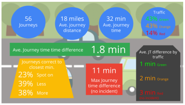
I conducted 56 individual trips with an average distance of 18 miles and journey time of 32 minutes. The trips were mainly from my house in Hampshire to locations in the South of England. I spent an average amount of each journey on motorways, A and B roads, with the odd country lane thrown in for good measure. I also recorded the traffic conditions based on the Google Maps navigation app and if the whole route equaled green, orange or red traffic. The majority of my trips were in green or orange, but I did have some with red traffic for comparison.
Considering the number of journeys I undertook and their average time and distance, I think an average of 1.8 min out of predicted journey time is a very good result. This gives me a lot of confidence about the accuracy of Google Maps journey times. It also gives me a lot of confidence that the technology we are offering to our customers is the best and most accurate there is.
One thing to note is that the journey time accuracy went down based on the amount of traffic on the route and the distance travelled. This is expected as those two variables make predicting journey times much harder. However the accuracy does not fall by a significant amount and my confidence in Google’s journey accuracy stays high even when undertaking long trips in traffic.
One further thing to note is I excluded from the results any trip that had an unpredictable incident such as a car crash, although there was only one such incident over my trips.
How does Google Maps work out journey times?
Google calculates journey time by measuring the distances between your two chosen points, and applying any speed limits that are in place on the route to provide a perceived average speed for the journey. This is then used to compute the forecast arrival time at the destination.
Crucially, however, Google Maps also layers over additional live, real-time data to ensure that these trip times are as accurate as possible. Data is sent anonymously to Google from Apple of Android smartphones that have Google Maps open, or from any Android device that shares location information. This data is then used to provide real-time updates on traffic congestion and incidents, which is then taken into account alongside the distance and typical journey time to provide a more reliable and realistic estimate.
The evolution of Google Maps journey time predictions
Google Maps journey time predictions have evolved to the point where they can now give highly accurate real and predictive journey times, even over long distances and in rush hour traffic conditions. These journey times have a wide range of uses, not only in the consumer world to help people navigate and understand when they will arrive at their destination but also in business and government to help improve customer service and plan new infrastructure.
I believe the journey times provided by Google Maps are the most accurate available in the UK and Europe, and most probably in the world. This information can help businesses and government services improve the services they provide and do so in a much more cost effective manner. I will be exploring some of these use cases and how Google predicts its journey times in subsequent posts.
Working with a Google Maps Premier Partner
A Google Cloud Partner like Ancoris can help you apply the power of Google Maps to solve current business challenges and develop new digital models using location-based services .
We’re not only a Google Maps Premier Partner but have achieved Google’s Location-Based Services Partner Specialisation. This means we’ve demonstrated both technical proficiency and proven success in building and managing applications using the best of Google Maps Platform and Google Cloud Platform in both web and mobile environments.
If you’d like to find out more about how we can help you, why not take a look at some of our customer success stories or talk to the experts in our Google Maps team .
Article updated June 2022 First published February 2018
< Back to resources
Think big. Start now.
We don’t believe in Innovation, we live it. Innovation combined with pragmatism is what runs through our veins. We ask ourselves the same question over and over again: Does it deliver value? And how quickly? Your big ambitions can start now.
Talk to an Expert
How-To Geek
Waze vs google maps: which one is really better.

Your changes have been saved
Email is sent
Email has already been sent
Please verify your email address.
You’ve reached your account maximum for followed topics.
Quick Links
Navigation: getting from a to b, exploring: restaurants, gas stations, and everything else, offline maps & customization, waze vs google maps: conclusion, key takeaways.
- Google Maps is better for planning routes with various transportation options (walking, biking, etc.) Waze is better for up-to-date traffic info and frequent route adjustments based on real-time situations.
- Google Maps is superior for finding detailed information about places (restaurants, gas stations etc.) including reviews and browsing menus. Waze is less useful for exploration.
- Google Maps allows downloading specific areas for offline navigation. Waze downloads route data only for the current trip. Waze offers fun features like avatars and themes, Google Maps has limited customization options.
Google Maps is one of the most popular apps for Android and iPhone. Waze, is another popular mapping app, and it happens to be owned by Google, too. The two services have borrowed many features from each other over the years, but they're still distinctly different. So which one is better?
To keep things simple, we're going to break this down into three categories: Navigation, Exploring, and some additional features. Any navigation app should be simple enough to just work—the last thing you need to worry about when getting around in unfamiliar territory is fiddling with the app that's supposed to be taking you to where you're going.
Obviously, navigation is the most important part of any map app. They need to take you where you actually want to go. When it comes down to it, both Google Maps and Waze do the job! And that's not surprising, given that Waze and Google share a lot of maps and traffic data. That said, there are some big differences.
Google Maps tends to determine a route when you start navigating and mostly sticks to it throughout the trip. Waze users can report things like road closures, speed traps, broken-down vehicles on the side of the road, and other hazards. This information is then used to adjust the route while you're driving. Google may ask if it's okay to change your route, but Waze will just do it.
Traffic reporting is one of the features Google has borrowed from Waze, but it's a different experience. If you use Waze, you'll notice a lot more reports popping up on the map. Google Maps does not have a "community" feel, so things are not reported as often. And as mentioned, Waze actually does a lot more with the information during your trip.
All that said, Google Maps has one significant advantage over Waze. While Waze only offers driving navigation, Google Maps provides navigation if you're walking, biking, ride-sharing, or using public transit. In those situations, Google Maps is the much better choice.
If getting you to where you're going is the most important aspect of any good map app, then knowing the surroundings is easily second on that list—in fact, the two almost go hand in hand.
When it comes to knowing what's around you, both Waze and Maps do a good job. You can search for locations by name and pretty much find what you're after. On Google Maps, you can pan around the map and easily spot lots of locations. Waze tends to show a lot fewer locations (but it loves to highlight parking lots) and you can't tap on locations easily.
Google Maps and Waze can show you not only the location of businesses you search for but also their hours of operation, phone numbers, departments, and more. Unsurprisingly, the information for both is coming from Google—including the reviews shown on Waze—so it's pretty similar on both apps.
This is where the interface and design differences really come into play. Google Maps is clearly more intended for exploration than Waze. While you'll find similar information on both, Google has much more, and there's much more you can do with it, too. You won't be looking at restaurant menus, ordering food, seeing the busiest hours , and checking gas prices in Waze.
A location page on Google Maps is stuffed to the brim with information. It might actually be too much information, but the fact is Google provides a ton of helpful information right from within the app. If you use Waze, you'll probably want another app for exploration.
The way each app handles offline data is interesting. Google Maps lets you download a specific area for offline navigation so that you can start navigation without a data connection. You could even navigate an entire route without needing data. By comparison, Waze only downloads the route data after navigation has started and only for that particular navigation session, which is much less useful. Sure, if you lose data while driving, then you should still be good, but that's the extent of its usefulness.
One big point in Waze's favor is an element of just plain fun. Other Waze users and their customized avatars and cars appear on the map (if they enable it). You can collect candies and other items while driving. Every year around Christmas, new themes and voices are added for your Holiday travels . There's tons of different voices and themese to choose from in Waze. Google will let you change your car , but that's about it.
Waze vs. Google Maps is similar to a "David vs. Goliath" situation. While they may have the same owner, you really wouldn't know it by looking at them. Google Maps is far and away the company's favorite, as it should be. Maps is an incredibly popular and powerful app that millions of people rely on every day. Waze feels more like a pet project that Google keeps around.
Regardless of which mode of transportation you're using, Google Maps will get you to your destination, and it will have a lot more information about that destination, too. Waze will get you there with more fun (assuming you're taking a car). Therein lies Waze's one big advantage over Google Maps.
Waze is great if you want your navigation to change on the fly to adapt to current conditions . This is especially helpful if you're someone who drives a considerable amount every day. Waze's proactive route adjustments can save you time that Google Maps wouldn't bother with. For the average person, it may not matter much, but frequent drives could benefit over time.
At the end of the day, Google Maps is a comprehensive travel service . It's an understatement to call it a "navigation app" or simply a "map app." Waze, on the other hand, is much more focused. It's heavily geared toward navigation, and it does that well. Google Maps stands on its own, but Waze may need some companion apps to fill in the gaps.
- Apple iPhone
- Apps & Web Apps
Pocket-lint
I tested google maps against waze to see which is actually better.

Your changes have been saved
Email is sent
Email has already been sent
Please verify your email address.
You’ve reached your account maximum for followed topics.
Key Takeaways
- I use Waze and find that it excels at driving navigation with real-time updates.
- I've been trying Google Maps, and it does offer a wider choice of navigation options.
- Honestly, both apps are useful. But here's how they compare, head-to-head.
Big companies love to buy smaller companies. There are countless small companies that have created useful Apple apps, but they were then bought out by Apple and turned into iOS features. Siri was born out of a voice assistant app, and the Weather app on your iPhone is based on the excellent Dark Sky app that Apple bought and then killed off . Apple isn't the only culprit, however. Google loves to buy other companies, big and small, as well.
Its major acquisitions include YouTube, Nest, and Fitbit . And, in 2007, Google bought the navigation software company Waze.
Unlike Apple, however, Google didn't steal the best bits of Waze and then kill off the original app. Instead, we find ourselves in the curious position where both Waze and Google Maps exist as rival apps owned by the same company. So, which app should you use for your navigation? It's a good question and one that isn't always that easy to answer. I use Waze, but I downloaded Google Maps again and put both navigation apps head-to-head to find their pros and cons.
5 reasons why I use Waze instead of Google Maps
Google has two free navigation apps: Waze and Google Maps. Here's why, after all these years, I still use Waze over Google Maps.
Driving navigation
Both can get you from a to b.
Waze is an app that's dedicated to driving navigation . This is also one of the primary functions of Google Maps, although it does have other navigation options which we'll look at in more detail later. How do the two apps compare when using them to help you navigate when driving?
Both apps allow you to select a destination and will then generate driving directions to that destination from your current location as determined by your phone. It's also possible to set a different starting point than your current location. This is far simpler to do in Google Maps; it's not immediately obvious how to change the starting point in Waze.
Once you’ve entered a destination, Waze will give you some alternative route options to choose from, with information about the distance and the estimated time of the journey. You can also see an outline of the routes on the main map screen.
Google Maps works in a similar fashion, but it will only give the information for what it considers to be the optimal route. You can see other routes on the map screen, along with their estimated journey times, but you'll have to tap each route on the map to see information such as the total distance.
Once you've selected a route and started navigating, Google Maps is focused on getting you from A to B on the route that it considers the best option. Unless something major occurs on the route it's chosen, you'll stick to that route for the whole journey. Google Maps will offer better route options if it finds them, but this is less frequent than with Waze.
Waze uses a slightly different approach; it will happily change the route if it believes this will get you to your destination more quickly. If there's an issue on your route reported by other Waze users, or traffic gets too heavy, Waze will offer to change your route and give you information about how much time you'll save by changing to the new route.
10 hidden Google Maps features, tips, and tricks to try
We've all used Google Maps to get from A to B, but did you know it has an AR view? We've rounded up secret Google Maps features you might not know.
Traffic and other information
Waze has more up-to-date info.
Both apps make use of data from other users to make informed decisions about the best routes to take. If other Google Maps or Waze users are driving on the same route as you (or at least part of it), then both apps will have data on how fast traffic is moving on that part of the route, which can help it to provide more accurate journey times.
What Waze does much better than Google Maps is provide additional information submitted by other Waze users. It's possible for Waze users to report issues such as heavy traffic, but also hazards such as cars stopped at the side of the road, speed traps, road traffic accidents, and more. This information is then instantly made available to other Waze users who are driving the same route. I've always been impressed by the accuracy of these reports; Waze will often inform me of a car stopped by the side of the road, and it's almost always there when I reach that point. If it isn't, I have the option to mark the hazard as no longer there.
Google Maps has added the ability to report crashes, speed cameras, congestion as more, but this isn't nearly as ingrained as in Waze. Many Google Maps users may be unaware that the features exist, meaning the data is spotty at best.
7 secret Waze tips and tricks you absolutely need to try
If you think you know Waze, think again. You'll get even more from Google's other navigation app using these hidden tips and tricks.
Waze can be glitchy
Until recently, if you asked me whether Google Maps or Waze was more accurate in terms of estimations for your journey times and estimated time of arrival, I would have said that they were both equally accurate if the journey is uneventful. The estimated journey times are usually fairly close for both apps for the same journey, and although the ETA can change during the course of your journey, both apps are good at updating the ETA accordingly.
However, recently I have found an occasional error in Waze . It recently estimated that driving to a local theme park that I know to be about 50 minutes away would take more than two hours. Google Maps estimated 48 minutes. I wondered if this was due to an issue en route such as an accident, but when I changed the destination to a road near to the theme park, Waze changed the ETA to 49 minutes. The drive did indeed take about 50 minutes. This may be a one-off glitch, but it's concerning, as if I hadn't known the duration of the drive already, I could have easily believed it would take more than two hours.
That being said, Waze's ability to update the route based on the current conditions means that while both apps will get your there in a similar amount of time if there are no issues on your journey, Waze may be able to get you there quicker if there are issues such as accidents or heavy traffic that occur on your journey.
I tested Waze against Apple Maps to see which is actually better
If you own an iPhone, Apple Maps comes pre-installed, but is it better than other apps? I go head-to-head with Apple Maps vs Waze to see which wins.
Other navigation options
Google maps has walking, cycling, etc., while waze is limited.
One major difference between Google Maps and Waze is that Waze is intended solely for driving navigation. If you want to walk somewhere, take public transport, or even cycle the same route that you would drive, Waze can't help. You can use the driving directions if you're cycling, but the estimated journey time will be wildly inaccurate, and the route may include roads that aren't suitable for cycling.
Google Maps, on the other hand, can offer multiple navigation options, including public transport directions, walking directions that include footpaths that aren't navigable by car, and cycling routes. It can even provide flight information for longer journeys. If you want to navigate by anything other than a motor vehicle, then it's a no brainer; Google Maps can help, and Waze can't.
How often does Google Maps update Street View?
Can't wait for your renovated house to show up on Google Street View? Here's what you need to know about how the feature gets updated.
Local discovery
You can plan more stops with google maps.
When you're driving from A to B, you may need to make some stops. You might need to fill up with gas, for example, or stop to get something to eat. Both apps allow you to search for amenities on or close to your route so that you can plan these stops.
In Google Maps, you can search for gas stations, restaurants, coffee shops, rest stops, supermarkets, hotels, and more. The app will then display these results on the map so you can see how far out of your way you'll need to go. You can select one of the results and add it as a stop to your navigation directions . Google Maps allows you to add multiple stops to your routes.
Waze offers similar options. You can search for fuel, food, parking, groceries, coffee, hotels, pharmacies EV charging stations , and more. However, unlike in Google Maps, you can only add one stop to a route. If you want to visit a gas station and a restaurant, for example, you'll have to create a new journey navigating to your first two stops, and then create another one to get you to your final destination.
One major benefit of Waze if you're looking for somewhere to fuel up is that searching for gas stations will bring up results on the map that include the current prices at those gas stations, allowing you to find the cheapest option. Some of this information is provided by the fuel retailers, and some is submitted by other Waze users. You don't see this information Google Maps.
What is Google Maps Immersive View and how can you use it?
Learn how to explore a new place from the comfort of your home with Google Maps Immersive View.
Additional features
Waze offers more personalization.
Waze is built around a social aspect, with other users providing information that benefits anyone who's using the app, such as traffic or hazard information. You can see other Waze users on your route shown as small car icons on your map, and Waze allows you to customize how your car displays to other Waze users.
You can also make other customizations, too. One of the most popular is the ability to select different voices for the voice navigation. Celebrity voices are often available as part of promotions for movies or products, and there are usually some festive voice options available in the holiday season, such as the Spicy Gingerbread Man or Santa. It's even possible to record your own voice and hear yourself telling yourself where to go.
Waze has also recently added some new features , including roundabout navigation and speed limit alerts.
Google Maps is far less customizable. You can change the voice language, but there's no option to choose amusing voices to keep you entertained as you drive.
Google Maps has some unique features of its own, however. You can download maps for use offline , meaning you can keep navigating even when you don't have an internet connection. Waze relies on having an internet connection to work. Indeed, if you're starting your journey somewhere remote, you may not be able to see any directions until you've reached somewhere where your phone can get a network connection. Google Maps also allows you to see a street view of your destination which is useful if you're going somewhere you've not been before.
Both apps allows you to connect music services such as Apple Music , allowing you to control your music directly from the app screen when you're driving.
What is Google Maps AR navigation and Live View and how do you use it?
Get a better view of where you're going.
Google Maps is clean and Waze has fun cartoons
The two apps look quite different. Google Maps has a more professional look with clean design that matches the other Google apps. In comparison, Waze looks a little more fun, with the cartoon icons that represent other Waze users appearing on the roads on the map.
Google Maps also unsurprisingly makes use of the impressive amount of imagery that it has captured, allowing you to see a realistic satellite view of your route rather than simple graphics like you get with Waze.
How to measure a distance with Google Maps
Measure the distance between two or more points using Google Maps on any device.
Google Maps vs Waze: Which should you use?
It depends on what you need, but both are free.
There's no simple answer to this question. That's because there are horses for courses, and each navigation app has its strengths and weaknesses.
If you want to navigate somewhere on foot, by public transport, on a bike, or even by plane, then the decision is an easy one. Google Maps can offer directions for all of these circumstances. In comparison, Waze is only any use if you're driving from A to B.
If you are driving, however, then the decision becomes a lot tougher. If your goal is to get where you want to go as quickly as possible, the Waze has the edge. It's more proactive in rerouting you if there are issues with the original route that you've selected. Google Maps will update your route, but it's not nearly as frequent. If there are problems on your journey, Waze is likely to get you to your destination before Google Maps does.
Waze can also provide more details and up-to-the-minute information about hazards such as vehicles parked at the side of the road or traffic accidents. It means that your journey might be a little safer using Waze, too.
Google Maps
Personally, I've used Waze for years. However, recently I've started using Google Maps a little more, not least because of the strange errors in the journey time that have occurred a couple of times. The beauty is that both apps are free to use, so there's no reason why you can't keep both on your phone and use whichever one is most suitable at the time.
How To : See What Traffic Will Be Like at a Specific Time with Google Maps

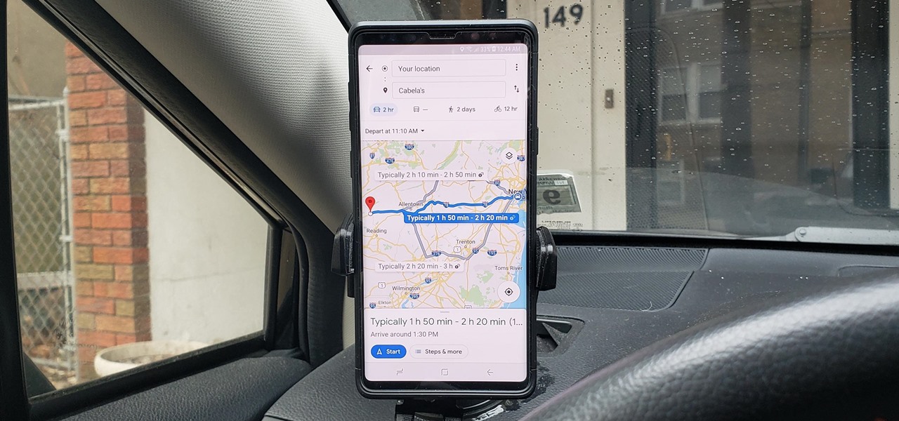
As intuitive as Google Maps is for finding the best routes, it never let you choose departure and arrival times in the mobile app. This feature has long been available on the desktop site, allowing you to see what traffic should be like at a certain time and how long your drive would take at a point in the future. Fortunately, Google has finally added this feature to the app for iPhone and Android.
To try this out, you'll need to update your Google Maps app, which you can do with the links below. When you do, you'll be able to plan ahead by choosing arrival and/or departure times, which is ideal for seeing when you'll need to leave if you want to get to your destination by a specific time.
- Get the latest version of Google Maps: Android | iOS
Setting Departure or Arrival Times
Scheduling a trip based on either when you'd like to leave for, or arrive to a desired location couldn't be easier with Google maps — simply input your destination as you normally would within the the search field along the top of the screen. Tap on "Directions" after doing so to yield available routes.
Afterward, choose the best route a from the selections given. From there, tap on the three-dot menu button on the upper-right and hit "Set depart & arrive time" (Android) or "Set a reminder to leave" (iOS) from the prompt.
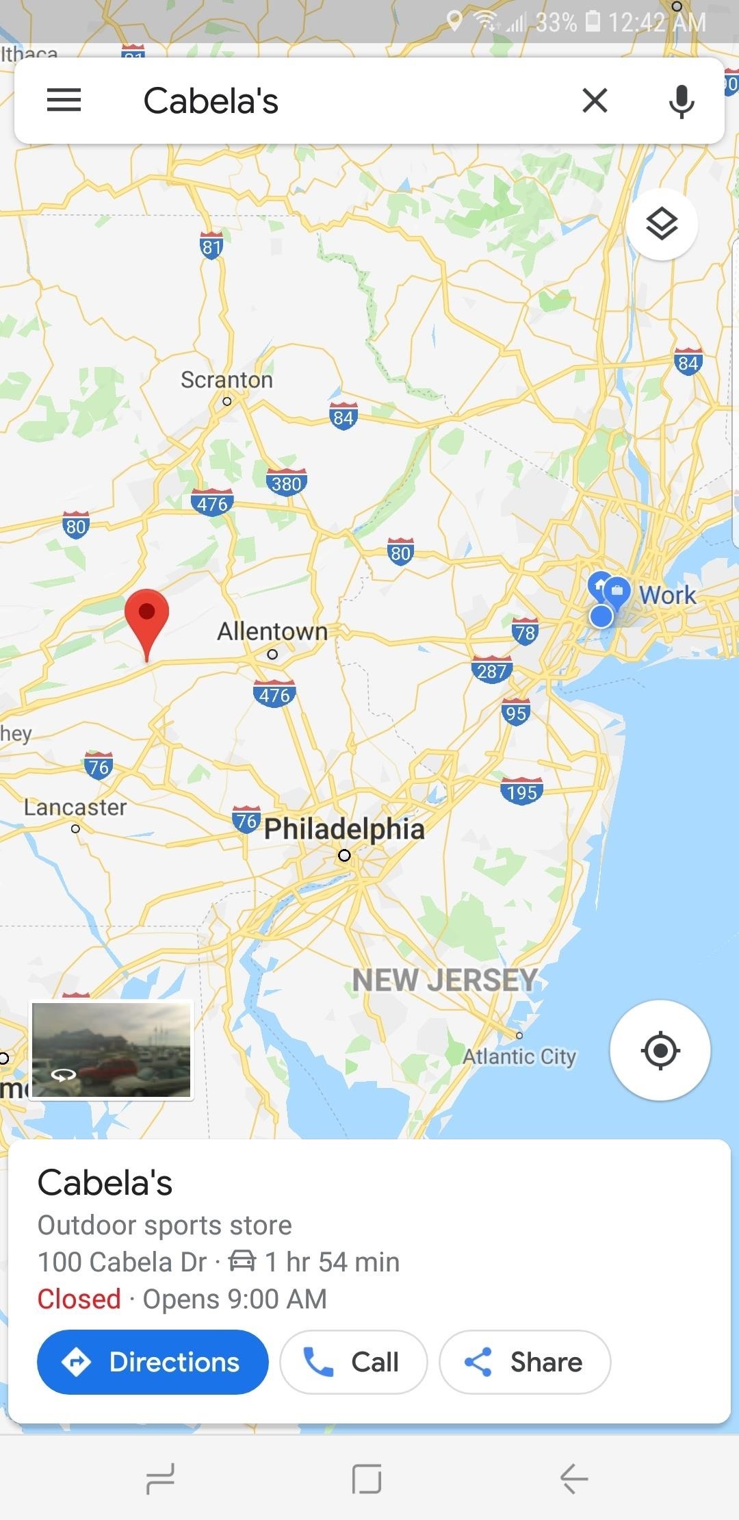
Now, either set the time and date you want to "Depart At" on the time table given, or tap on the "Arrive By" tab on the upper-right and adjust the time and date the same way if you want to arrive by a certain time. Hit "Set" once you're done, and Google Maps will yield average travel times for the route, along with either an ETA if you picked the former, or a suggested time for departure if you chose the latter.

As handy as this new feature is, it's worth noting that it does have some limitations. Google Maps currently won't alert you via a notification if you set a departure time. Besides that, traffic conditions aren't updated in real-time, so arrival times can vary, and drastically change due to unforeseen events like traffic accidents and sudden weather downturns.
Just updated your iPhone? You'll find new features for TV, Messages, News, and Shortcuts, as well as important bug fixes and security patches. Find out what's new and changed on your iPhone with the iOS 17.6 update.
Be the First to Comment
Share your thoughts, how to : make spoofed calls using any phone number you want right from your smartphone, how to : prevent people who have your contact information from finding your instagram account, how to : the trick that lets you link to specific start times in youtube videos right from your phone, how to : see who's viewed your tiktok profile (and how to stop them from knowing you visited theirs), how to : redial busy phone lines automatically on your iphone or android phone, how to : find out whether your phone has an lcd or amoled display (& why it matters), how to : this hack turns any phone into a black light, how to : hide facebook messenger groups without letting other people know you left, how to : we tested the best burner phone apps for iphone & android — here's our top 4, how to : convert tiktok videos to live wallpapers for a more animated home or lock screen, how to : easily remove unwanted people and objects in your photos with google's magic eraser, how to : change the notification sound & call ringtone in facebook messenger, news : snap releases lens studio 4.0 with 3d body mesh & more, upgrades scan as fashion assistant, how to : here's why it's harder to steal a samsung phone than an iphone or another android, how to : use voice control on the apple iphone 3gs, how to : ssh by usb using ifunbox with firmware 3.0, how to : this is the quickest way to add a new contact on any phone, how to : find all the reels you liked & saved on instagram, google photos 101 : how to make your own gifs out of pictures you've taken.
- All Features
- All Hot Posts
Google Maps vs. Apple Maps: Which navigation app is best?
Is Google or Apple the best option to get you from A to B?
- Availability
- Public Transit
- Street View
Should you get your directions from Google Maps or Apple Maps ? It's a decision all iPhone users have to make at some point — regardless of whether you're a long-time iPhone user or just picked up your first Apple phone. In the past Google Maps was the king of navigation, while Apple Maps was met with eye-rolls and stiffled laughter. These days that's no longer the case
Apple Maps has come leaps and bounds in the years since launch, with regular updates each year, and the people have started to notice . The fact Apple Maps is pre-installed on every iPhone also gives it a narrow edge over Google. And with essential feature like offline navigation now on offer, and topographic maps with hiking support and custom routes bundled inside iOS 18 , the gap between the two is smaller than ever.
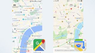
But picking between the two navigation apps isn't easy. Google Maps and Apple Maps both have a lot to offer, and the two don't really have many unique features any more. So to help you decide which one if right for you, we're pitting Google Maps vs Apple Maps. Here's how the two compare.
Google Maps vs. Apple Maps: Availability
Like most Apple services, Apple Maps is exclusive to the company’s own line of products. They don’t call it a walled garden for nothing. That means anyone not using an iPhone, Mac, or some other Apple-made device has zero way of accessing it.
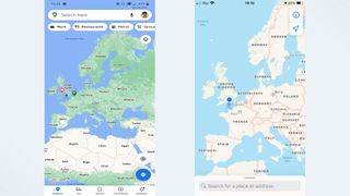
Google Maps is the complete opposite, and is available in some form on just about every device out there. Android, Windows, iPhone, Mac, even Apple’s CarPlay. Should you ever find yourself with a new device and in need of directions, your existing familiarity with Google Maps is going to serve you well. Logging in with your Google account also automatically syncs all your data, including journey history and favorite locations.
While Apple does have a lot of devices, all of which have some form of Apple Maps available, it’s not enough to beat Google’s near-universal availability.
Winner: Google Maps
Sign up to get the BEST of Tom's Guide direct to your inbox.
Get instant access to breaking news, the hottest reviews, great deals and helpful tips.
Google Maps vs. Apple Maps: Interface
After several years of refinement, Apple Maps and Google Maps both offer a very focused interface that’s easy to use. That said, the way they present that information is quite different.
Apple Maps takes a very simple approach to this, with an interface that keeps pretty much everything in one place for ease of use. Recent search history, saved locations, and information about businesses and places can be found when you expand the search bar.
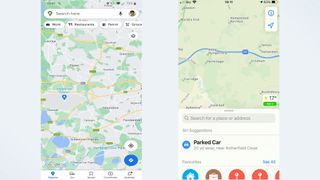
Crucially, that search bar stays where it is until you click on a place, and if you want to get rid of it all you have to do is tap the X button in the corner.
Google on the other hand, has buttons and toolbars all over the place. At the top of your phone screen is the search bar, which also houses account information and sits above dedicated buttons for finding local amenities. If you’re ever needing to find a restaurant or gas station fast, that’s likely to be very useful.
Likewise at the bottom of the screen is a menu giving you access to the Explore and Commute features, saved locations, local news, and the option to contribute to Google’s mapping database. All of these things will vanish if you tap the middle of the screen, so you can see a pure uncluttered map, but it’s still all a bit much.
Winner: Apple Maps
Google Maps vs. Apple Maps: Map Design
Like its interface, Apple Maps has opted for a more minimalist approach to its map design. While it has a lot of information at its disposal, Apple Maps doesn’t actually show you very much unless you zoom all the way in. Similarly, Google shows you more information when you zoom further in, but it does start showing a lot of that information much sooner than Apple Maps does.
That said, both of them always show the essentials no matter how you’re viewing the map. Roads, locations, landmarks, it’s all there. The only real difference is how much surplus information is on display, including businesses, smaller road names, and so on. Likewise both of them use a dark mode that makes it easier on your eyes during any late-night driving you need to be doing.
iOS 18 will also see Apple Maps add a topographical map interface , with support for hiking trails. That includes turn-by-turn directions, just like you'd get on the road, and the ability to tweak the route yourself. Google Maps does have a terrain layer, but nothing quite so extensive.
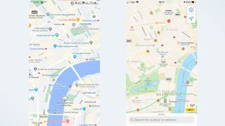
Both apps have the information you need, but Apple Maps’ less-is-more approach makes it much easier on the eyes. Google Maps’ excess information can be distracting sometimes, and that’s the last thing you need if you’re lost and struggling to orient yourself.
Winner : Apple Maps
Google Maps vs. Apple Maps: Navigation
There’s very little difference in how Apple Maps and Google Maps actually gets you places. Both services follow your progress as you travel, including travel time and journey distance, your current ETA, and the most relevant instruction at that point in time. So if you need to stay on the freeway for another ten miles, that’s what it’ll say. But as soon as you have a turn coming up it’ll change and let you know.
Both services are capable of telling you what current conditions are like on your route, including traffic, road closures, and so on. Both apps will also suggest alternate routes if the one you’re on is particularly congested, though neither of them are as aggressive as the Google-owned Waze.
It doesn’t matter how you intend to travel either, since Apple Maps and Google Maps can generate directions for drivers, walkers, cyclists, and those travelling by public transport.
As far as navigation goes, the differences between Google Maps and Apple Maps can be almost identical, or they can be as different as any route between two points can get.
For instance, driving from my house to our London office generated identical 51 mile routes and an ETA of 1 hour and 13 minutes. Going by train is a little different: Google Maps thought I’d get there in 58 minutes, versus 57 minutes on Apple.
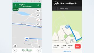
Neither app gave me much option to alter the routes. Apple Maps skipped the toll road, even when I’d set it to allow tolls, and wouldn’t give me the option of taking it. Likewise Google didn’t have any suggestions that involved leaving the freeway one exit later. Instead the only alternate routes on offer were so wildly different that all three routes diverged almost as soon as I left home.
However if you're taking your trip on foot, iOS 18 now lets Apple Maps users create their own custom routes. This is primarily designed for hiking, and will be useless if you're driving any sort of vehicle, but it's a helpful option to have. Especially if you know of a better route in the area.
It’s a bit strange that both apps offer primary routes that are similar, but the alternates were so wildly different.
Regardless of which one you have, you can be sure that the optimal route will get you to your destination in roughly the same amount of time.
However, Google Maps has the added advantage of letting you add multiple stops to your route ahead of time. Apple Maps does allow you to add pit stops mid-route, but that’s only really to let you get gas, or have something to eat. It’s not for, say, setting up a route to your Mom’s house to pick her up, and then carrying on to your grandparents without starting a brand new route.
Google Maps is also updating the way it calculates its routes, with the aim of prioritizing safety and optimizing fuel consumption. So it's going to use a number of factors, including real-time traffic data, to find you a route that uses less fuel and is less likely to cause an accident, but without affecting your final ETA too much.
So Google very narrowly clinches the win thanks to the added convenience of journey planning.
Google Maps vs. Apple Maps: Traffic
Both Google Maps and Apple Maps have access to real-time traffic data, and can let you know if you’re going to face any problems along your route. Whether it’s road closures, heavy traffic, or something else entirely, it shouldn’t come as a huge surprise. Naturally both apps let you report problems on the road, be they accidents, speed cameras, or general hazards that may affect travel times.
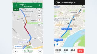
Google does have an edge here, thanks to the presence of its “Commute” feature. Once you’ve set up your work and home locations in the settings, tapping commute shows you what sort of journey you can expect. It’ll tell you how long the journey will take, what major roads you’ll be taking, and how busy those roads are. If that route isn’t to your liking then you can pick one of a number of different options.
Google Maps will also let you adjust your departure or arrival time in the app itself, something Apple Maps does not do. The apple Calendar has a “travel time” feature that can do much the same thing, but that relies on you setting up a calendar event with the Travel Time feature turned on. Convenient in some contexts, sure, but it’s also a convoluted process that definitely could do with some streamlining.
Apple Maps lets you save your work and home addresses as well, among other locations. It makes it faster to generate directions for places you go to regularly, but it requires a few extra steps that Google Maps’ Commute skips out. Google also has the advantage of all that extra historical and real-time data.
Google Maps vs. Apple Maps: Public transportation
If travelling by car isn’t your thing, both Google Maps and Apple Maps can include public transportation information in their directions. In both apps it’s as simple as picking a destination and then hitting the “public transport” option at the top of the screen.

Both services include data from multiple transit authorities, timetables, ride-sharing services, and status updates, but Google still has the advantage. Because it has data on where Google Maps users are, plus a mix of historical and crowdsourced data, Google can estimate just how busy the public transport system is at any given time.
Google Maps is even expanding this feature to show you how crowded particular areas or neighbourhoods are later this year . Like the Commute feature, all of this means you can see exactly what to expect and change your route accordingly.
But Apple Maps has started catching up in iOS 15. Apple Maps now prominently displays station information at the top of the screen and lets you pin your favorite transit route for easy access. The update also prompts users when they're approaching their stop, so they make sure to get off at the right time.
Both services are able to offer real-time transit information, including live departure times, schedules, outages and delays. Apple Maps can also tell you the location of a bus or train that's en-route, so you know just how far away it is.
However Apple Maps still doesn't feature information on how busy a particular service is, which puts it at a disadvantage. While this feature was first hinted at in the iOS 14.5 beta, nothing has materialized as of the release of iOS 16.
This system seemed to work in a similar fashion to Google, crowd-sourcing the rough location of Apple Maps users to gauge how many of them are in any particular place. But, thanks to Apple's privacy stance, this information would be anonymized and encrypted before it gets sent off to Apple servers. It's un clear why this feature hasn't been publicly released yet, but it's possible the privacy features aren't quite up to scratch.
Winner: Google Maps, for now
Google Maps vs. Apple Maps: Discovery
There’s more to navigation apps than finding directions from point A to B. Both Google Maps and Apple Maps have features that lets you see what’s around, helping you find restaurants, gas stations, parking lots, and any other businesses or points of interest for those times you don’t know where you’re going.
Google Maps puts this in plain view, with buttons underneath the search bar and a larger list of categories if you scroll to the end. There’s a button for pretty much anything you’d need, while the Explore tab at the bottom of the screen gives you a more generalized overview of the area.
Upcoming changes to this feature will also see Google offer more specific recommendations when you're looking for things. For example searching for restaurants in the morning will be more likely to show up coffee shops and places serving breakfast, rather than locations only open for lunch and dinner.
Apple Maps does something similar, which you’ll see if you tap and expand the search bar. “Find Nearby” works in exactly the same way, letting you pick a category that’s relevant to the area you’re looking at. Sadly there’s no full list like Google has, and you’ll only see a handful of options which will change depending on which specific area you’re looking at. Apple Maps also has something called “Guides” which imports relevant editorial content that should help familiarize you with any given area.
Google Maps’ Explore results can capitalize on a wealth of Google’s information, which is collected first hand and through crowdsourcing. Contact information, opening hours, whether business is limited thanks to the pandemic, it’s all there. Google knowing where people are at any given time also means it can estimate how busy a place is. So if a restaurant or a supermarket is particularly congested, you’ll be able to see that ahead of time.
Google also has future plans to expand this feature by letting you see how busy the foot traffic is in certain neighbourhoods or locations. Plus you'll be able to see this from the map itself, rather than a business's page.
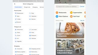
Apple Maps has a lot of that information thanks to partnerships with third party services like Yelp, Foursquare, and TripAdvisor, but not as much as Google Maps does. It doesn’t offer live updates on how busy a business is, and despite hints in the iOS 14.5 beta this feature is still missing as of the launch of IOS 16.
Apple also offers a 'Curated Guides' option, which arrived as part of iOS 15, offering recommendations on places to go when you're in a specific city. These guides can be saved and update automatically, so you're always up to date. Alternatively you can choose to create your own personal guide to share with friends and family.
Google has something similar in the works in the form of " Vibe Check ", a crowd-sourced tool that's designed to help newcomers discover hidden gems in an unfamiliar area. It highlights things you should check out, and showcases information submitted by the locals.
This feature also reveals the "vibe" of an area, so you can figure out what the general feel of the place is. However Google Maps is yet to launch the feature, promising only that it will arriver "in the coming months".
Apple Maps’ less-is-more approach does ensure a much cleaner interface, however. Whereas Google's insistence on including as much as possible means things can feel a little cluttered at times. Likewise Apple currently has the edge for quickly finding out what's worth checking out when you visit a new place — though that may change fairly soon.
Despite the potential for information overload, Google still comes out on top in this instance. The app is able to put its data collection to good use by ensuring you know if you’re heading somewhere at the wrong time. The fact the app doesn’t pick and choose Explore categories for you is also a win, and something Apple Maps definitely needs to copy. But Apple Maps appears to be catching up, and Google’s dominance may not be so certain for much longer.
Google Maps vs. Apple Maps: Hands-free control
Hands-free control is important if you’re driving, because you can’t be constantly tapping your phone to get things done. Apple Maps and Google Maps both have hands-free control, though they do work differently.
Apple Maps is connected to Siri , which is installed on every iPhone by default. That means you can get everything set up right away, without any unnecessary extra steps.
Siri does work with Google Maps now, but you have to specify where you want to send the command. Otherwise Siri will default to Apple Maps, and there's currently no way to change this. So you’ll have to say “Hey Siri, get me directions to work with Google Maps” because simply asking for directions to work will open up Apple Maps instead.
Alternatively you can download and set-up Google Assistant, or turn off Siri in Google Maps' navigation settings. That lets you use "Ok Google" commands while Google Maps is open. Similarly you can toggle voice commands by tapping the microphone button on screen.
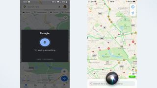
Over on Android both Google Maps and Google Assistant are pre-installed, meaning you can set up hands-free commands right away. Obviously Apple Maps isn’t available there, though again you do have the choice to skip the assistant and toggle voice commands with an on-screen button.
Tapping the screen every time you want to tell Maps to do something isn’t the best scenario, because you’re supposed to be concentrating on the road. It doesn’t matter which device you’re using.
Apple Maps has the edge if you use an iPhone, because everything is interconnected and you don’t need to deal with the hassle of downloading a new assistant or specifying which service you want to use every time. Google Maps has the edge on Android, but that’s primarily down to the fact Apple Maps isn’t available.
Winner: Tie

Google Maps vs. Apple Maps: Street view
If you need a different way of looking at the world, then Street View is a very helpful tool as it shows a location from your own point of view, rather than a map’s standard top-down perspective. It’s particularly helpful for orienting yourself in a strange location.
Google’s Street View has been around since 2007, and over the past 14 years it’s expanded across the world. Not everywhere, and you’ll find large portions of countries like Germany and South Korea don’t have Street View coverage, nor does mainland China. Still it’s in a lot of places.
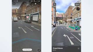
Accessing it is easy, and all you have to do is change the map type to the Street View option, and click an area highlighted in blue. You then have the choice to either navigate in a split-screen mode that relies on you tapping locations on the map to get around, or by tapping and swiping within Street View itself.
There's also the added advantage of Live View directions, which uses AR to overlay directions on what your phone can see — helping you navigate more effectively. Live View is also set to get upgrades in the near future, which should add even more value to this mode. That includes seeing business information and busyness levels, and the ability to search for specific services or locations . All from street level.
Eventually Google's 'Immersive View' will let you view the interior of business or location from your phone. But so far this feature is still officially "coming soon".
The downside to Live View is that relies on there being Street View coverage. Which is fine in a lot of public places, thanks to Street View's extensive coverage. But if you find yourself not covered, AR directions won't be available.
Apple Maps’ equivalent is called “Look Around,” and since it only launched in late 2019, it’s nowhere near as extensive. You’ll only find Look Around spots in major cities in the U.S., U.K., Japan, Ireland, and Canada right now. Accessing and navigating this mode used to be a little different, but things have changed.
In the past navigating meant physically selecting a spot on the map and scrolling around to go from place to place. That's no longer the case, and while the method still works you can now explore in much the same way as Google Maps. Tap a spot on screen and Apple Maps will take you there. Nice and easy.
iOS 15 also saw the launch of AR directions, with Apple users able to raise their iPhones to scan nearby buildings to work out exactly where you are — and show you where to go in a real world context. It's pretty much identical to how Google Maps does it, if you're already familiar with Google's equivalent.
With these two changes it means Google Maps and Apple Maps are functionally identical. However Google Maps still wins on account of its head start, and the sheer number of locations it's managed to document. Still, don't expect Apple Maps to stay on the sidelines for too long.
Google Maps vs. Apple Maps: Privacy
Apple has gone all in with privacy over the past few years, and Apple Maps is no exception. While privacy and live navigation seem pretty incompatible, Apple has developed a process called “fuzzing” that ensures anonymity.
Rather than requesting a route from A to B, Apple Maps sends off multiple requests with multiple identifiers that masks where you’re trying to go. The app also converts your precise location to a less-exact one after 24 hours, and Apple itself doesn’t store any information about where you’ve been or what you’ve been searching for. Plus none of the information that reaches an external server is associated with your Apple ID.

Any personalized data Apple Maps does have is stored on your device, rather than a server where it’s out of your control. That means you can go into the settings and delete it at any time, safe in the knowledge that it is gone for good.
Data can still be backed-up and synced across multiple devices, via your personal iCloud storage, but this doesn’t happen automatically. Because uploading that data to a server, no matter how secure, is riskier than keeping it on your device, you have to deliberately opt in first.
Google Maps does none of that. Instead pretty much everything you do gets routed through Google’s servers, and the information gleaned from your travels and searches can be used to better personalize Google’s ads. Because that’s how the company makes its money, and the more relevant the ads are to you the more valuable they become.
Measures are taken to ensure advertisers don’t learn too much about you as an individual, but it’s not entirely anonymized in the same way Apple Maps’ navigation requests are.
Google Maps does have an Incognito Mode, just like the Chrome browser, which limits the amount of data that is saved. However that doesn’t stop the fact everything has to go through Google servers first, so the only way to actively avoid Google Maps from keeping tabs on you is to stop using it and delete the app.
Google Maps vs. Apple Maps: Verdict
Google’s practice of data collection is key to making Google Maps a superior service to Apple Maps. Or that’s one way of looking at it. Since Apple Maps is run with a focus on user privacy, Apple can’t utilize data to make improvements. So Google can offer real time updates showing how busy a store or train might be, that’s always going to be well out of Apple’s reach.
But at the same time using Google Maps means knowing everything you do, and everything you search for, is being collected and analyzed for Google’s own benefit. When it comes to GPS and your actual location, that’s going to be too much for the more privacy-conscious.
Discovering new places is easy on Google Maps, but only just. Apple just needs to offer a full list of categories, rather than just giving you what it thinks is the most relevant. Similarly Google Street View is more widespread, but it also had a 12-year head start that puts Apple’s Look Around at a clear disadvantage. Apple Maps does offer a cleaner design and simpler interface, which is much more appealing than Google Maps’ relatively cluttered approach.
Most of these comparisons are arbitrary in the long run. Google Maps may well have won more categories than Apple Maps, but numbers don’t tell us everything. The most important thing to consider is the actual navigation, and it turns out there isn’t really a wrong answer here.
Google Maps’ and Apple Maps’ navigation performances were basically identical, and it means whichever one you pick you’ll be well served. It’s just up to you to decide which is right for you and what sort of journeys you plan to take.
If you value privacy above all else, or are happy with the default Mapping app on your iPhone, go with Apple Maps. However if you prefer a service that offers more information and puts your data to work improving what you see, then go for Google Maps. It’s all up to you.
Tom is the Tom's Guide's UK Phones Editor, tackling the latest smartphone news and vocally expressing his opinions about upcoming features or changes. It's long way from his days as editor of Gizmodo UK, when pretty much everything was on the table. He’s usually found trying to squeeze another giant Lego set onto the shelf, draining very large cups of coffee, or complaining about how terrible his Smart TV is.
Best iPhone apps in 2024
Gmail's AI Q&A feature comes to Android — what you need to know
Pixel Pro 9 Fold has the same weakness as Google’s first foldable
- Yazzoo7 Has anyone else noticed how poor the Google Maps graphics on Android Auto are compared to the Google Maps graphics on Apple CarPlay? For example, the search box in "Auto" is always visible which causes your vehicle travel to always be displayed significantly off-center. The result is seeing more of the traffic history from where you already passed instead of where you are headed. Also, the traffic flow definitions (green, amber, and red) in Auto are much thinner than in CarPlay and not as easy to see. For these reasons, I purchased a used, non-activated iPhone 6S, pair it with my Galaxy S9+ hotspot and use Google Maps in CarPlay for my navigating needs. Reply
- Porrotu I prefer Google just because you can skip to the next steps/turns. I like seeing beforehand the street where I should be turning, etc, with a map of it (not just a list). Reply
- CmdrBozo I'm now using Apple maps because I prefer a few of the navigation features not available with Waze or Google, like "turn left at the next stop sign,." Also I appreciate more warning for the next step, e.g. after a turn, " in 1 mile turn right at the traffic light" There are some Google advantages, such as better lane markings. I use all three depending on the situation. Reply
- Ronald Quint As a long haul Truck Driver, I use both. Google maps navigation has a more realistic E.T.A. Apple maps navigation has a persistent dedicated distance to go feature. If Apple maps could dial down their E.T.A., I believe it would increase highway safety. Reply
- hg0428 Apple maps now has Multi-stop routing as of September 2022 Reply
- MistyMu Apple Maps also has an "Arrive By" feature now built in. I think one area Apple Maps could improve is discoverability. Also, I would like the see offline map support. One thing that did impress me with Apple Maps is walking directions. Both have walking directions, but I live in a rural area and Apple Maps suggested the public footpath, Google Maps takes you a 15 min detour by road. You can't actually see the path on the Apple Maps interface (you'll need something else for that like Ordnance Survey, but at least it knows there is a path. Apple Maps is still very limited with cycling directions though and only works in a few major cities right now, whereas Google Maps works everywhere. I can't speak for using either for public transport. I do like that on Google Maps you can drag different routes out with the web app with a mouse, but while you can send the route to your phone (you can send route to phone on Apple Maps as well) it won't send the custom route you dragged out. It is interesting to see both apps getting EV support now as well, which will be useful for those with non-Tesla EVs to help plan journeys with charging stops, because the built-in car nav either doesn't have this built in or it is bad. Reply
- Joe Bowers Just upgraded. + Does now do multi stop route, including the total time AND distance, which Google refuses to provide on Apple app platform. - Once you start navigating, you cannot go back and Edit the route to change, add or remove a stop, instead you get a blank editor and have to start again. Apple Map very hard to share and only a single stop journey. Also saving routes is not provided to recall later., Google is great at this. Reply
- View All 7 Comments
Most Popular
- 2 PS5 Pro is overpriced — here’s why I’m buying one anyway
- 3 Galaxy S25 — 5 things Samsung needs to learn from the iPhone 16 launch
- 4 3 best action movies on Amazon Freevee right now
- 5 Facial recognition is the best feature to come to smart locks in years—here's why
- ⋙ Start Here
Search suggestions:
Popular searches:.
- Best cycling jeans
- Urban cycling brands
- stylish helmets
- Gifts for cyclists
Google Maps Bike Speed: How Fast Does It Assume You Cycle?
By Matthew Chandler
Updated Aug 15, 2023
Contributors
This post may contain affiliate links, which help to keep Discerning Cyclist rolling. Learn more .
Google Maps Bike Speed
Google Maps assumes a standard cycling speed of roughly 16kph (10mph) for its estimates. However, the speed can vary based on factors like gradient and intersections, influenced by past GPS data from other users. It doesn’t adjust for weather, time of day, actual personal cycling speed, or route surfaces.
If you take your bicycle out for a spin and end up venturing into the unknown, embrace it. Not only because you might find your new favourite cycling route, but because as long as you’ve got signal on your smart phone, you’ve always got good old Google Maps to bail you out if need be.
Introduced in 2005, before adding bike-specific functions in 2010, Google Maps has plenty of cycling benefits. For one thing, it actually shows you where the bike lanes in your area are , but it also gives you a rough estimate of how long it will take you to ride from your current location to your destination.
Obviously, this can be seriously different in reality if you go significantly faster or slower than the speed they use. So, what speed does Google Maps use for biking? And are Google Maps cycling times accurate all the time?
Why is Google Maps Cycling Speed Important ?
Google Maps cycling speed is important so that you can:
- Plan the duration of your journey ahead of time.
- Find the quickest or most accessible routes.
- See how much longer it will take you if you took a quieter or scenic route.
How Fast Does Google Maps Assume You Bike?
Google Maps assumes a standard moving speed of roughly 16kph (10mph) irrespective of the length of your journey.
It also does not take into account time lost due to stopping for water, checking directions, and so on, while it uses the average stopping time for traffic lights, rail crossings and other stops.
Yet people often say they complete their journeys before the clock hits Google Maps’ estimated time of arrival (ETA), so don’t take that speed as gospel. There are other factors at play, of course, as we’ll get onto next…
Does Google Maps Adjust Cycling Speed?
Yes. Google Maps bike speed alters for each part of the route based on factors such as gradient and the number of intersections, while GPS data previously logged by other Google Maps users can also affect it.
Cycling speed is not adjusted because of:
- Weather conditions
- Time of day (and so the amount of congestion)
- Traffic lights – it assumes all cyclists wait until red lights turn green
- Route surfaces (e.g. off-road cycle paths, bumpier, less even terrain)
- How fast you cycle on average
How Does Google Maps Calculate Bike Time?
Don’t just take our word for it. Richard Russell, an ex-Google engineer, used Q&A site Quora in 2013 to expand on how Google Maps calculates speed.
Asked if ETAs are determined by speed limits or actual travel time by previous users , he said: “These things range from official speed limits and recommended speeds, likely speeds derived from road types, historical average speed data over certain time periods… actual travel times from previous users, and real-time traffic information.
“They mix data from whichever sources they have, and come up with the best prediction they can make.”
Is Google Maps Good for Cycling?
Of course – it offers you multiple routes from A to B, giving you a pretty good estimate of how long each will take.
But it’s not perfect, either. As we’ve established, there is a sense of uniformity about its ETAs which, while rarely if ever wildly inaccurate, aren’t exactly geared to individual cyclists or specific factors mentioned above, like weather or traffic.
That said, credit where it’s due – it’s still pretty reliable, and is always adding new improvements, including a visual overhaul last summer courtesy of algorithmic analysis of satellite imagery, which tries to automatically decipher the nature of the environment.
Then, late in 2020, Google Maps launched a messaging function, so verified businesses can now communicate with customers directly from the Google Maps app. Its performance insights were also updated, as well as adding Street View contributions straight from your phone, and a Community Feed.
And as of March 2021, Google Maps have started defaulting to the route with the lowest carbon footprint, rather than the fastest, in a bid to make it more eco-friendly.
Google Maps Alternatives for Cycling Routes
If you decide you no longer want to be of the billion-or-so users of Google Maps, you’re at least spoilt for choice when it comes to picking another app.
Google Maps may offer great ease of use and arguably the most contemporary data, but some understandably feel uneasy about the amount of information it logs about you.
So, if you’re looking for something a little more private, niche or under-the-radar, these are a few good recommendations:
- Apple Maps – for iOS users, obviously, but Apple Maps is, perhaps a little surprisingly, one of the most privacy-friendly options available. It doesn’t like to your Apple ID or retain a search or cycling history, and when you save locations across devices, it uses end-to-end encryption, so Apple itself can’t view them.
- OpenStreetMap – like a Wikipedia of maps, where the users update it themselves through GPS devices, aerial photography and their own manual changes. No-frills, non-profit, only collects limited data, no logins or ads – simple but effective. The only real downside is it has no official app, so isn’t exactly tailor-made for smart phone users.
- OsmAnd – best for when you’re looking for previous users’ experience, it uses the OpenStreetMap database, which allows them to provide more precise live traffic updates. Available both online and offline, it’s also free with a Premium subscription from $1.99 a month. It also has tools to change the look of maps, ‘dark mode,’ and Wikipedia integration.
- CycleStreets – a UK-wide, non-profit journey planner, which offers a choice of four different route modes based on the type the user prefers. It also saves previous routes, tells you how many calories you’ll burn on a route, as well as how many traffic lights you’ll come across and how busy it is.
- Bike Citizens – an app which, through logging its users’ journeys, will then suggest the best routes for you, or help you explore a new city through a ‘cycling tour’ curated by the area’s regular riders.
Discerning Cyclist Store
Visit the Discerning Cyclist's Shop
Ride in style
Join our weeky newsletter to get early access to our latest discoveries.
Related reads
Flat tire no problem here’s a step-by-step guide.
By Herman Eloff
10 Facts About Cycling to Work That Will Encourage You to Ride Even More
5 common cycling challenges in the city and how to overcome them, beautiful beasts: 8 eye-catching bikes we’re obsessed with right now.
By Charlotte Broughton
The Perfect Bike Setup for Women: 5 Tips for Maximum Comfort
6 things female cyclists are tired of hearing .
Android Police
Google maps vs. waze.

Your changes have been saved
Email is sent
Email has already been sent
Please verify your email address.
You’ve reached your account maximum for followed topics.
Google Maps is preinstalled on most Android phones, but Waze is a popular alternative many use for directions. Despite Google owning both apps, they offer different approaches to navigation with unique features that can make one a better choice for your day-to-day traveling. We explain what makes each app unique and why one or the other might be better for your navigation needs. Waze is unavailable on WearOS. If you're considering jumping into the increasingly impressive world of Android smartwatches , stick with Google Maps.
A short explanation of Google Maps and Waze
Google Maps has been around since 2005 and is the go-to navigation choice for most Android users. It's preinstalled on most Android phones, and its helpful features make it more than a navigation app. From leaving reviews, checking traffic, filtering restaurants by dietary requirements, and seeing how much you've traveled, there are many great Google Maps features that many people aren't even aware of.
Waze, founded in 2008 and bought by Google in 2013, focuses on driving personal vehicles. It gives real-time journey updates by relying on users to enter information about traffic, speed cameras, accidents, road closures, or anything affecting road conditions. It doesn't provide information on public transport and only offers limited information about nearby businesses.
Google Maps vs. Waze: Transport options
Google Maps should be your go-to option when traveling by public transport, taxi, bike, or foot. Waze shows public transport routes but doesn't provide walking directions along roads. If you frequently travel by bus or train, use Google Maps to stay up to date on timetables and route times.
When it comes to traveling by car, competition is tighter. While driving directions are only one of Google Maps' features, the entire Waze app is built around helping drivers get from A to B as quickly and safely as possible. We break down what each app offers drivers to help you choose which app to use.
Google Maps vs. Waze: Safe driving features
Many apps offer driver-friendly features, such as increasing the size of essential UI elements and activating voice commands for actions. Google Maps and Waze are designed for use in your car, so they have plenty of features to ensure you can safely navigate while driving.
When you start a journey, both apps have large UIs that are easy to interact with. You don't need to hunt through menus and windows to perform everyday actions. For example, both apps let you navigate to nearby locations (for example, gas stations) with a few taps. You don't need to type any information.
How to set your commute in Google Maps
Get to work on time and avoid rush hour with Google Maps's commute feature
You can also issue instructions via voice commands. For example, on both apps, you can say, "Hey, Google, take me to the nearest gas station," and they automatically redirect you.
For driver safety, Waze wins out. While Google Maps follows the company's trend of prioritizing aesthetics over practicality, Waze's interface is bright, bold, and intuitive.
Google Maps vs. Waze: Traffic information and hazards
Both apps provide real-time traffic updates but display them in different ways. Waze's reliance on user input means you can expect almost instantaneous updates in busy areas. Google Maps' is slower at identifying hazards and traffic jams.
While using Waze, the app prompts you to check if a reported hazard or traffic slowdown is still there. If you respond negatively, the app removes the hazard from everyone's maps if other drivers agree. There's a constant stream of updates on hazards or traffic slowdowns, along with drivers' estimated speeds.
Google Maps color-codes roads from red to green depending on traffic congestion. You don't see estimated speeds or receive real-time updates. Google Maps allows you to report hazards or speed cameras, but it doesn't prompt you like Waze.
For up-to-date traffic information, Waze easily wins. The data is more detailed and up-to-date. However, due to the reliance on users, hazards may go unreported for a while in rural areas.
Google Maps vs. Waze: Trip planning
Both apps provide trip-planning features. While Waze offers a detailed breakdown of traffic and estimated arrival times, Google Maps' public transport information gives a better idea of the options available.
Waze's trip planning tool makes it easy to check the estimated arrival time from your date and time of departure by car. It's accurate and quick to use. You can connect it to your calendar to receive notifications of the best time to leave.
Google Maps' trip planning isn't convenient when comparing different times, but it is more detailed. The app automatically generates alternative public transport routes even when exploring private transport options. Even if you're planning to drive, you might discover that a train is the faster option. Something that's impossible with Waze.
If your only transport option is driving, Waze is the better choice for trip planning. If you want to see all your options, Google Maps provides a detailed breakdown of every transport option that gets you to your destination.
Google Maps vs. Waze: Discovering nearby locations
Google Maps and Waze support discovering nearby gas stations, restaurants, coffee shops, and other locations. Google Maps' extensive database of businesses and user reviews is more informative than the information Waze provides.
Google's business information pages contain opening times, reviews, menus, photos, updates, contact details, and more. The app is a comprehensive guide to nearby services, whether in the middle of traveling or planning a trip.
Waze offers a limited selection of nearby location options and only displays crucial information like opening times, contact details, and reviews. It's helpful in a pinch but switch to Google Maps or Yelp for a comprehensive guide to nearby businesses.
How to record and use your voice for Waze Navigation
Make it sound like you!
Google Maps vs. Waze: Which is best for you?
Google Maps' comprehensive database of routes and locations makes it the perfect companion if you like to explore all your transport and location options before setting off. While offering unparalleled real-time updates for driving, Waze is useless when it comes to public transport and has limited offline support for routes. In contrast, Google Maps can save entire regions offline.
If you drive regularly, Waze will help you get from A to B as fast as possible while minimizing the risk of hazards. If you're exploring a new location or regularly use public transport, Google Maps should be your go-to navigation app. Either way, both are compatible with Android Auto .
- Applications
- Google Maps
- Privacy Policy
- Terms and Conditions
- GIS Analysis
- Maps & Cartography
- GIS Software
- GIS Mapping
Unveiling The Truth: How Accurate Is Google Maps?
- May 29, 2023 June 4, 2023
Google Maps has revolutionized the way we navigate and explore the world. With just a few taps on your smartphone, you can find your way to a new destination, avoid traffic, and discover nearby attractions. However, with so much reliance on Google Maps, one question that often comes up is how accurate is google maps? In this article, we’ll explore the accuracy of Google Maps, the factors that affect its reliability, and how you can use it effectively.
Google Maps is generally accurate but its accuracy can be affected by several factors such as obstructions, weather, interference, and the number of satellites in view.
How Accurate Is Google Maps?
When it comes to navigation, Google Maps is one of the most widely used tools in the world. It provides users with the ability to find their way around, locate businesses, and explore new areas with ease.
At its core, Google Maps is powered by a complex algorithm that combines data from a variety of sources. This includes satellite imagery , Street View, and information submitted by users. With this data, Google is able to create a comprehensive and detailed map of the world that is constantly being updated.
Another way that Google ensures the accuracy of its maps is by allowing users to submit corrections. If a user notices that something on the map is incorrect, they can report it to Google, who will review and make the necessary changes. This means that the map is constantly being updated and improved.
How Google Maps Works?
Google Maps uses a combination of GPS, Wi-Fi, and cell tower signals to determine your location. When you search for a location or enter an address, Google Maps uses this information to generate the best route to your destination. Google Maps also provides real-time traffic updates to help you avoid congested areas and save time.
Accuracy of GPS
GPS technology is generally very accurate. It can determine your location within a few meters or less, depending on the quality of the GPS receiver and the number of satellites in view. However, GPS signals can be affected by several factors, which can result in reduced accuracy.
Accuracy of Google Maps Directions
Google Maps provides accurate directions in most cases, but it’s not perfect. In some cases, Google Maps may provide inaccurate or outdated directions due to changes in road layouts or traffic conditions. However, Google Maps allows users to report inaccuracies, which can help improve the accuracy of directions over time.
How Accurate is Google Maps coordinates?
Google Maps coordinates are generally considered to be quite accurate, with a margin of error of just a few meters. This is because Google Maps uses a combination of GPS data, cell tower triangulation, and Wi-Fi signals to determine your location.
GPS data provides the most precise location information, but it can be affected by buildings or other structures that block the satellite signal. Cell tower triangulation and Wi-Fi signals can help compensate for this by providing additional location data.
However, it’s important to keep in mind that the accuracy of Google Maps coordinates can vary depending on a number of factors. For example, if you’re in an area with poor GPS signal, your location accuracy may suffer.
Additionally, Google Maps may not be able to accurately determine your location if you’re in a crowded area with a lot of interference from other devices. In general, though, Google Maps coordinates are considered to be quite reliable, and the app is a useful tool for navigating to a specific location.
If you want to ensure that you are getting the most out of Google Maps, it is important to keep it updated and to report any inaccuracies that you notice. This will not only help to ensure that the map remains accurate, but it will also benefit other users who rely on the tool for navigation and exploration.
Conclusion:
Overall, Google Maps is a highly accurate and reliable navigation tool that has revolutionized the way we navigate the world. However, like all technology, it’s not perfect, and there are factors that can affect its accuracy. By understanding how GPS technology works and how Google Maps uses it, you can use this tool effectively and ensure that you arrive at your destination safely and on time.
Is Google Maps always accurate?
Google Maps is generally accurate, but it can be affected by several factors such as obstructions, weather, interference, and the number of satellites in view.
Can Google Maps work without a data connection?
Google Maps requires an internet connection to download maps and directions, but you can download offline maps for use without a data connection.
How often does Google Maps update its maps?
Google Maps updates its maps on a regular basis, but the frequency depends on the area and the availability of new data.
Can I trust Google Maps for driving directions?
Google Maps provides reliable driving directions, but it’s always a good idea to double-check the directions and to be aware of any changes in road layouts or traffic conditions.
Leave a Reply Cancel reply
Your email address will not be published. Required fields are marked *
Save my name, email, and website in this browser for the next time I comment.
This site uses Akismet to reduce spam. Learn how your comment data is processed .
- Help Center
- Google Maps
- Privacy Policy
- Terms of Service
- Submit feedback


IMAGES
VIDEO
COMMENTS
It's accurate for short trips only. Supposedly you're driving from Bay Area to San Diego around noon. Google map won't take into calculation (in the beginning) that in about 5 hours, you'll be driving through LA area during rush hour. It really depends on where you're driving.
It's pretty accurate for travel time once you're actually on the train, but doesn't take into account waiting for a train. I usually pad it by 5-10 min for this. It's great at train times. It gets inaccurate with walking times. Sometimes it seems to expect me to jog everywhere. Other times it vastly overestimates how long it takes.
In my experience, pretty damn accurate, but for longer distances, it can be around 10-15 mins longer than the estimate. Stuff can happen to slow down during that trip. Extremely. It's very accurate but any slight thing can change the traffic pattern, like people slowing down to watch somebody change a spare tire.
I have this route planned in Google Maps as a rough plot for travel times to 4 locations from Tokyo Tower, it's by no means finished. ... on this topic on reddit (it was about why speeding seemed to match the accuracy). Some of the discussion will be of interest: ELI5: When I get driving directions from Google Maps, the estimated time is ...
Left: Google Maps; Right: Waze (Image credit: Tom's Guide) Customization is a very small part of what both apps can do, but if you want to better express yourself through your navigation app then ...
4. Google Maps provides a feature to estimate your arrival time based on typical traffic along your route. It provides this time as a range, e.g., "typically 1h - 1h 50m" Based on that, if you select to arrive at a specific time (vs. leave now or depart at), it will tell you what time to leave given the high end of the range.
Google calculates journey time by measuring the distances between your two chosen points, and applying any speed limits that are in place on the route to provide a perceived average speed for the journey. This is then used to compute the forecast arrival time at the destination. Crucially, however, Google Maps also layers over additional live ...
Google Maps and Apple Maps will do just fine, but Waze is a cut above for driving to a new place from your current location. Its maps are simpler than the others, with larger icons, brighter ...
Google Maps is superior for finding detailed information about places (restaurants, gas stations etc.) including reviews and browsing menus. Waze is less useful for exploration. Google Maps allows downloading specific areas for offline navigation. Waze downloads route data only for the current trip. Waze offers fun features like avatars and ...
Google Maps will offer better route options if it finds them, but this is less frequent than with Waze. Waze uses a slightly different approach; it will happily change the route if it believes ...
Get the Reddit app Scan this QR code to download the app now. Or check it out in the app stores ... ELI5: When I get driving directions from Google Maps, the estimated time is usually fairly accurate. However, I tend to drive MUCH faster than the speed limit. ... I find I usually beat the estimated travel time by about 5-10%. While, yes, I ...
As intuitive as Google Maps is for finding the best routes, it never let you choose departure and arrival times in the mobile app. This feature has long been available on the desktop site, allowing you to see what traffic should be like at a certain time and how long your drive would take at a point in the future. Fortunately, Google has finally added this feature to the app for iPhone and ...
With these two changes it means Google Maps and Apple Maps are functionally identical. However Google Maps still wins on account of its head start, and the sheer number of locations it's managed ...
Google Maps Bike Speed. Google Maps assumes a standard cycling speed of roughly 16kph (10mph) for its estimates. However, the speed can vary based on factors like gradient and intersections, influenced by past GPS data from other users. It doesn't adjust for weather, time of day, actual personal cycling speed, or route surfaces.
If you frequently travel by bus or train, use Google Maps to stay up to date on timetables and route times. ... real-time updates. Google Maps allows you to report hazards or speed cameras, but it ...
This help content & information General Help Center experience. Search. Clear search
On average, Waze uses 0.23 MB each hour. As for Google Maps, the app gobbles up 0.73 MB every 20 minutes. That adds up to about 2.2 MB per hour. Waze's lower data usage is thanks in large part to the fact that Waze can be turned off. If you compare Apple Maps vs Google Maps, though, Google Maps comes out on top. 8.
Get the Reddit app Scan this QR code to download the app now. Or check it out in the app stores ... How does Google Maps estimate travel time so accurately even when there are multiple traffic lights? ... I ask because I am always astounded that it can be so accurate despite so many variables.
At its core, Google Maps is powered by a complex algorithm that combines data from a variety of sources. This includes satellite imagery, Street View, and information submitted by users. With this data, Google is able to create a comprehensive and detailed map of the world that is constantly being updated. Another way that Google ensures the ...
Google maps says it takes 30 minutes to bike to work but it's never taken me more than 21 biking there. I think google figures times on bikes at 10 miles per hour. Google gives me 22 min and I usually take 15 - 18 depending on effort/lights. If you use it enough it bases it on your personal biking speeds.
Google Maps said 14 hours of travel time. It took me 18 hours plus 1 hour of rest, there was no real traffic or Construction along the way. Speed limit is 100 km/h but many corners require me to slow down to 70.
Learn how to use Google Maps Timeline to track your location history and how accurate it is from other users' feedback.
Find local businesses, view maps and get driving directions in Google Maps.