het avontuurlijke leven van Antonette Spaan


Rimstigen – the forgotten hike in Nærøyfjord
Nærøyfjord is one of Norway’s smallest fjords and listed as one of Unesco’s World Heritage Sites. It receives many tourists each year that do the “Norway in a Nutshell trip” but not a lot of people get to stay there because there is almost nowhere to live. However, we were lucky and managed to stay at a prime spot next to the calm waters and steep walls of this outstanding piece created by Mother Nature. [Note that I hiked this trail in 2014 and have updated this article in 2018] Also read: the best unknown Norway hiking trails
Table of Contents | Inhoudsopgave
Hiking Rimstigen – great views in Nærøyfjord

Off to hike Rimstigen

Reaching Rimstigen

Heading back down
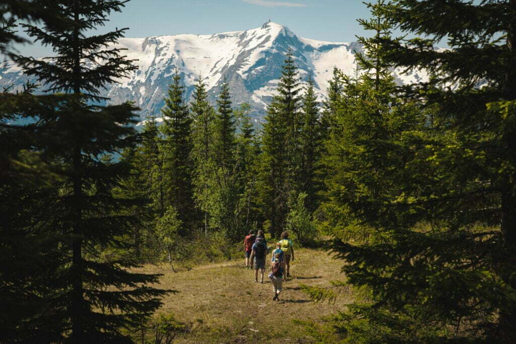
Within 90 minutes and taking it easy (the drops are really steep, if you fall, you will not make it) we hike down back to the house. Every now and then I look back over my shoulder the Rimstigen ridge. While walking down we pass various other couples and families on their way up. They are sweating and tired. I am happy we did this hike in the early morning when the sun wasn’t too hot yet. Once we’ve reached the house, the clouds have set in and the rain quickly starts. How glad I am I gave it one final push in time.
Our final thoughts
This hike eventually took us half a day and is a good alternative for those who don’t mind to work hard but can’t go all the way up. The Rimstigen hike is usually open from the beginning of June and even though you don’t get to the highest point in the mountains, there is still a great lookout from the ridge. Various website refer to this hike as being easy and that you can hike up in about 1-2 hours, but given the fact that for most hikers the maximum elevation gain is 400 meters in one hour, please bear in mind that two hours is more realistic. While in Norway we stayed at Dyrdal Gard . Our stay here was not sponsored but we mention the link as we would like to recommend everyone for staying here as it’s just an exceptional place. Please get in touch with the owner for questions! Anyone wishing to do this hike from nearby, can overnight in Gudvangen . From here it’s a short drive to the settlement of Bakka, where you can park your car and start the hike. Note that you cannot reach Bakka by public transport!
I hope you found this post useful and that you enjoyed reading it. Note that we’ve done this hike back in 2014 and some information may be outdated. If you find this to be the case, please let me know as I always try to take good care of updating articles where possible. In this article you’ll find affiliate links. If you make a purchase through any of those links, we may earn a small commission at no extra fee to you.
Related posts..

33 Comments

I love the second last photo – it has such depth. Such beautiful scenery, and especially for hiking. Your posts of Norway are just lovely.

thanks Alli!

Lovely photos – I think this trek would be worth every drop of sweat and an early morning wake up. It’s interesting thinking about what you wrote: “the abyss is really steep, if you fall, you will not make it,” as a hiker must confront that reality which is only a few feet away at many points. Thankfully, most of us have made it and can share the pictures to prove our efforts.
Yeah, as a hiker you must always pay close attention to what you do, or it may be fatal. However, it’s something you get used to, same as driving a car, really 😉

Margherita @The Crowded Planet
Such an amazing hike Anto. I would love to get some more tips from you as I’m planning a Norway trip for next year. I can relate with what you said about jetlag affecting your hiking… I experienced the same thing in New Zealand. Beautiful pics, I especially love the first one.
Keep an eye out for more posts to come about Norway Margherita, anytime this summer more will be online…

Breathtaking photos! I can understand why the hike was so worth it – that view is incredible. I’m glad that you pushed on through and made it! That doesn’t sound like much time to rest in between trips, so I can understand why you were tired. But, happy that you did this hike and are able to share it with us!

wow Norway looks so amazing! I can’t wait to visit one day. That hike has some amazing scenery- I’m sure it was worth the steep incline!

Chris Boothman
Nærøyfjord looks like such an amazing fjord to explore. In fact, just like the rest of Norway it is such an appealing destination that I can’t wait to get there and experience this for myself. Hiking around this part of the world with such stunning views and scenery is a must in my opinion for any aspiring travelers!
I’m sure you guys would love it. Now that I think of it, I don’t think I’ve ever heard anyone say they didn’t like Norway … 😀

Wesley Travels
Wouw, dat ziet er toch echt geweldig uit! Ziet eruit als paradijs.

Excellent hike! Those steps remind me of some I’ve been on, but never hovering over such beautiful fjords. 🙂
Thanks Bob – it was a great hike indeed. And the view, yes that was totally worth all the hard work 😉

The views are ridiculous! Great post, thanks for sharing you adventure :o)
Thanks Bex, the views were stunning indeed!

Great post and beautiful pics. Thanks. Plan on doing this in Sept. Check out my Arizona hikes on Youtube on channel Roy V Carter. What a difference.
Have fun, hope you won’t get any snow 🙂

My daughters and I hiked this trail July 2016. It was overcast and rained at times. It took us 3 hours to get to the top. We camped near the sign. We trekked down the next morning in slightly over 2 hours. The trail is steep but the views are incredible.
Oh wow camping there would have been awesome. Yes it’s steep indeed but the trail is great and the views even better. Thanks for sharing your experiences with us John!

Unforgettable landscapes of a wonderful country of Norway. https://youtu.be/Ugj_x4NlHfA
Thanks for sharing Mike!

Litteraly finished this hike 20mins ago. We are in gudvangen for the day and were looking for some hiking nearby. Somehow I stumbled over this post and we decided to do this hike because it seemed incredible. We don’t have much hiking experience but the blue trails felt a bit thame. Boy was this trail different. It took a lot of effort and willpower but we got to the top. And what a view! Not just the fjord but also the valley on the other side. It really is stunning. For anyone wondering. We are 2 25’s year olds in normal shape. Took us about 2,5 hours to get to the top and 1,25 to get back down. It’s a 100% worth it.
Yay, so nice to hear! Yeah it’s quite a strenuous trail but so much fun 🙂 I went back to Gudvangen last week but the road up to the hike was closed, so we had to skip it unfortunately. Hopefully next time, I’d love to go back again one day. I hope you enjoyed Norway!

Brandee Hommerding
Are we able to walk up the road to this trail? We are in gudvangen for the next 2 days and would love to hike this!
Ehm it’s a few kms from Gudvangen, not sure if you can walk because the drive goes through a tunnel, but I’m sure someone can give you a ride, it’s not very far from town. Enjoy!

There’s actually a blue trail next to the water. Its about 4km and very doable.
Ahhh good to know, thanks for letting us know 🙂

Chelsea Zimmerman
Hello, could you provide any specifics on how to get to this hike’s beginning? It sounds exactly like what I’m looking to do in July during my trip to this area. We will be staying in Voss.
Drive to Gudvangen, then follow the signs to Bakka (left side of the Naeroyfjord), through the tunnel. Bakka is a small settlement with a few houses. It’s been a few years but I’m sure there’s a signpost there.

Hi. Awesome post. Thx! Interested in this hike at end of August. Liked the camping at the top idea by one of the commenters. Will have a car. Question – Is there a good spot to park near the trailhead (leave a car there overnight) ?
Hey, not that I know of but I think it’s pretty safe to leave your car at the trailhead, it’s not a place lots of people go to and Norway is relatively safe … I’m in Norway now and feel totally comfortable leaving my car for a couple of days. Make sure to leave valuables out of sight though and enjoy the hike!

JULIEN GUILLEVIC
We are planning to go in Norway next summer, and this walk is already planned too. We have childrens 8 and 9 year old, they are used to trek and climb. Is there any tips to get before climbing there with kids? Also we would love to spend a night in our tent at rhe top. Is it makable too? Thanks for your valuable tips.
Hi, it depends on how well used your kids are to hiking. I guess for Norway standards it was an okay hike but it has been a while so maybe you can check locally as it may have changed over the past years. Good luck and have a great hike!
Leave a Reply Cancel reply
Your email address will not be published. Required fields are marked *
Notify me of followup comments via e-mail. You can also subscribe without commenting.
NORWAY – WESTERN NORWEGIAN FJORDS
A local's guide to the fjords in Western Norway.

AURLANDSFJORD AND NÆRØYFJORD – UNESCO WORLD HERITAGE
The aurlandsfjord and nærøyfjord in sogn are two of the worlds most beautiful and dramatic fjords. the name nærøyfjord origin from the norse god ‘njord’, the god of the seafarer and the sea..

The Aurlandsfjord and Nærøyfjord are two of many fjordarms in the 204 kilometer long Sognefjord. In 2005, the Nærøyfjord became a part of UNESCO’s World Heritage together with the Geirangerfjord.
Visit sognefjord.
Visit Sognefjord is the official destination company for the Aurlandsfjord, Nærøyfjord and Sognefjord area.
Hotels and accommodation in the Aurlandsfjord and Nærøyfjord area
Overview of hotels and other places where you can spend the night in the area around the Aurlandsfjord and Nærøyfjord.

Some highlights from the Aurlandsfjord and Nærøyfjord

Flåm, Aurland and Gudvangen are perfect starting points for experiences in and around the Aurlandsfjord and Nærøyfjord, two of the world’s most beautiful and dramatic fjords. On 14 July 2005, the Nærøyfjord together with the Geirangerfjord became part of our common UNESCO’s world heritage .
From Flåm you can take part in a fjord safari or a fjord cruise on the Aurlandsfjord and Nærøyfjord. You can take this fjord cruise as a round trip (both ways) or one way combined with bus between Flåm and Gudvangen. See the great view from Stegastein viewpoint , 650 meters above Aurland . Taste the local goat’s cheese in Undredal or in Skjerdal , two villages by the Aurlandsfjord.
Flåm Railway is the train journey from fjord to mountain, perhaps the most beautiful railway in the world. You can combine this train journey with cycling along Rallarvegen which goes from the high mountains via Flåmsdalen Valley to Flåm. Aurlandsdalen Valley is one of Norway’s most popular hikes. The lower part of Aurlandsdalen, which is also the most popular, starts from Østerbø and ends at Vassbygdi in Aurland.

The Flåm Valley is a beautiful adventure. The valley between Myrdal (866.8 masl) and Flåm by the Aurlandsfjord is 18 kilometer long. The valley is narrow and the mountains are steep, and there are waterfalls and rivers wherever you turn around. Flåm Valley is a great place for hiking and biking . Flåm Zipline sends you off at over 100 kilometers per hour, you are just hanging in a thin steel wire high above the valley.
By the Nærøyfjord, we have the small villages of Gudvangen , Bakka, Styvi and Dyrdal. Styvi is the only place without permanent inhabitants during the winter, and is together with Dyrdal without road connection. Gudvangen is one of two ports where the iconic ferry trip along the inner part of the Sognefjord departs and arrives. Visit the Viking village Njardarheimr in Gudvangen and experience the history and culture of the Viking Age.
The Nærøyfjord and Aurlandsfjord are both part of the 204 kilometer long Sognefjord which is located in the northern part of the county of Vestland, in the middle of Western Norway.

From Oslo and Bergen to the Aurlandsfjord and Nærøyfjord in one day

You can travel by train from Oslo or from Bergen to Myrdal and further by train down the Flåmsdalen Valley to Flåm. In Flåm, you can buy yourself a good cup of coffee and something good to eat at Flåm Bakery before you board the boat and join a Fjord Cruise on the Aurlandsfjord and Nærøyfjord. You can do all of this in one day, and best of all, the entire trip is sustainable.
You get to experience Bergen Railway , Flåm Railway , Flåmsdalen Valley, Flåm and the Aurlandsfjord and Nærøyfjord . Both train and boat on this round trip are electric. The boats run on batteries that are charged up on short-distance hydropower. The boats are both sustainable and silent, which makes the trips on the fjord an even better experience.

Winter – It is easy to understand why more and more people are discovering how beautiful and exotic the Norwegian fjords are in winter. The fjords is a fantastic playground for those who want to ski, go snowshoeing , take a winter fjord cruise or a RIB boat trip on the fjords or just take in the cold and fresh air and enjoy the beautiful winter landscape.
Flåm and Aurland are perfect starting points for exploring this area. It is a short distance to the fjords and the mountains and all the activities, attractions and sights you can do starting from these two fjord villages. Read about our winter trip to Aurland . The video below is from a winter trip from Oslo to Flåm. In the video we see Bergen Railway, Flåm Railway, Flåmsdalen Valley, Flåm, the Aurlandsfjord and Stegastein in winter clothes.
Season and Time to use – Day trip or more, season all year round. We recommend staying longer and experiencing more in this wonderful area.
Fjord Cruise on the Aurlandsfjord and Nærøyfjord

Here you will experience the Aurlandsfjord and Nærøyfjord (UNESCO World Heritage) in a fjord cruise from Flåm to Gudvangen.
The boats from run on batteries that are charged with electricity from short-distance hydroelectric power. The boat trips are both sustainable, climate-friendly and silent, which makes the trips on the fjord an even better experience.
Numerous wild and beautiful waterfalls and rivers characterize the landscape, crossing the rugged mountains and deciduous and coniferous forests on their way down to the fjords.
Beautiful villages with a sustained cultivated landscape with remainders of old farms and mountain pastures and unique cultural monuments gives a extra dimension to the dramatic natural landscape. Season: all year.
Flåm Railway – from fjord to mountain

Flåm Railway has been named one of the ten most beautiful railways in the world. It starts at Flåm at the inner part of the Aurlandsfjord and ends at Myrdal Train Station which is part of the Bergen Railway.
This is the train journey from fjord to mountain, and many people take the train ride both ways.
Flåm Railway is one of Norway’s most spectacular railways with its 20 tunnels and a gradient of 1 to 18 on almost 80% of the line. The train stops at Kjosfossen Waterfall where passengers can experience and take pictures of the wild and beautiful waterfall before the train continues on to the end stations which is Myrdal on the high mountain or Flåm down by the fjord.
Flåmsbana is also a fantastic experience in winter. It is highly recommended! Season: all year.
FjordSafari – Activities on and around the Aurlandsfjord and Nærøyfjord

FjordSafari offers guided activities, adventures and fjord excursions by RIB boat where you will get to explore the UNESCO world heritage site on and around the Aurlandsfjord and the Nærøyfjord.
The area represents an extreme, dramatic and a fantastic fjord landscape.
Their slogan is BOAT – HIKE – BIKE – SNOW, and they give you experiences that you will remember for the rest of your life.
Season: The activities and excursions can be done all year round, but they vary between summer and winter excursions.
Ferry trip on the Sognefjord between Gudvangen and Kaupanger

Kaupanger is one of two ports where the iconic ferry trip along the inner part of the Sognefjord departs and arrives.
This is a two and a half hour long fjord cruise on the Sognefjord and the Aurlandsfjord and Nærøyfjord , between Kaupanger and Gudvangen .
On this ferry trip you will see the mighty Sognefjord, where the fjord is at its widest. The outermost part of the Aurlandsfjord is narrower than the Sognefjord, but still quite wide. The Nærøyfjord is narrow and the precipitous mountains rise high above the fjord.
Countless rivers and waterfalls cascade down the steep mountain sides. On this ferry trip you can see and experience the stark contrasts and the beautiful and wild nature of this wonderful piece of Norway.
You can take your car on this ferry trip.
Season: Summer, see link for more information about season and scedule .

Waterfalls along the Nærøyfjord

Along the Nærøyfjord there are several beautiful waterfalls. Some of the most beautiful are Kjelfossen Waterfall at Gudvangen , which is located deep inside the Nærøyfjord, Tuftefossen Waterfall next to the Rimstigen trail at Tufto outside Bakka and Lægdafossen Waterfall at the very end of the Nærøyfjord.
Tuftefossen (680 meters high) and Lægdafossen (575 meters high) are best seen from a fjord cruise or from a fjord safari with a rib boat on the Nærøyfjord. You can see Kjelfossen (755 meters high) from the Viking village of Njardarheimr in Gudvangen, just look straight up in the southeast direction.
Below you can see a video from a fjord cruise on the Nærøyfjord, at the end of the video you can see the Lægdafossen Waterfall cascading down the steep mountainside.
Aurland by the Aurlandsfjord

In the middle between Oslo and Bergen lies beautiful Aurland. The idyllic fjord village that offers adventures and nature experiences in beautiful and wild nature.
It is a short way to well known tourist attractions such as Aurlandsdalen Valley , Aurlandsfjellet, Aurlandsvegen Mountain Road and Stegastein Viewpoint . But the Aurlandsfjord itself is perhaps the most beautiful and most famous of them all.
There are many activities you can do in this area all year round. You can take a Fjord Cruise on the Aurlandsfjord and Nærøyfjord or you can join a Fjord Safari in a RIB-boat to get even closer to nature.
In Aurland, there is something for everyone and not least a treasure trove of local food and drink, and is a perfect place to spend your holiday. Marianne Bakery and Café at Aurlandsvangen serves you a good atmosphere, the best of baked goods and a good selection of coffee and other drinks.
Flåm by the Aurlandsfjord

Flåm is one of several fjord villages located by the Aurlandsfjord. Flåm is a fantastic starting point for many great adventures in beautiful and wild nature.
Where the Aurlandsfjord ends, the Flåmsdalen Valley starts. If the Aurlandsfjord is an adventure, the Flåmsdalen Valley is an even more beautiful adventure, and both should be experienced.
It is easy to travel to Flåm. “All roads” leads to Flåm, and you can also get there by train via the Bergen Line and Flåm Railway. If you take the Flåm Railway down to Flåm, you will experience the beautiful Flåmsdalen Valley at the same time.
You can experience and do a lot with Flåm as a starting point. A fjord cruise on the Aurlandsfjord and the Nærøyfjord or a trip on the fjord with Fjord Safari is a must. So is a visit to Flåm Bakery , located on the quay near where the fjord cruise starts.
You can see and do a lot with Flåm as a starting point. In Flåm there are many places to eat and sleep. It is also a short distance to other beautiful fjords where you can visit idyllic fjord villages and experience beautiful and dramatic nature.
An autumn trip to Flåm by the Aurlandsfjord

One evening in October, I boarded the train at Oslo Central Station. I was going to take the train along Bergen Railway to Myrdal. Finally, I was going to experience the Flåmsdalen valley, the Aurlandsfjord and the Nærøyfjord in autumn colours again. It had been far too long since the last time.
I joined a fjord cruise on the Aurlandsfjord and the Nærøyfjord. Never have I seen these fjords more beautiful than this day. Here are some words that I got from a tourist who was on the same boat trip. He posted the comment on a timelapse video I made from that fjord cruise:
– My girlfriend and I were on this cruise that day and it was truly a magical morning. The water was like glass and the rising sun kept changing the mountain views all around us as we silently glided through the fjord.

Guided Kayak Trips on the Aurlandsfjord and Nærøyfjord

The Aurlandsfjord and Nærøyfjord are great to explore from a kayak.
You can join guided kayak-trips both in Flåm at the inner part of the Aurlandsfjord and in Gudvangen at the inner part of the Nærøyfjord.
- Guided Kayak trips on the Nærøyfjord and Aurlandsfjord – Start from Gudvangen
- Guided Kayak trips on the Nærøyfjord and Aurlandsfjord – Start from Flåm
NOTE – For safety reasons, we recommend you to join a guided kayak trip if you are going to paddle kayak on the fjords. Here are some good advices on how you can be safer when kayaking on the fjords and during other activities and when traveling in Norway and Western Norway in general.
Season Kayak: Summer, check with the guide companies when they offer guiding. Seasons mentioned on this website are approximately dates.
Flåm Valley

The Flåm Valley is a beautiful small adventure. The valley between Myrdal (866.8 masl) and Flåm by the Aurlandsfjord is 18 kilometer long. The valley is narrow and the mountains are steep, and there are waterfalls and rivers wherever you turn around.
Flåm Valley is a great place for hiking and biking . Flåm Zipline sends you off at over 100 kilometers per hour, you are just hanging in a thin steel wire high above the valley.
Rallarvegen ends in the Flåm Valley, and you can take the train up and down the Flåm Valley with Flåm Railway . Brekkefossen Waterfall is a popular hiking goal in the Flåm Valley.
Flåm Zipline – The longest zipline in Norway
Take the Flåm Railway from Flåm to Vatnahalsen Station or Bergensbanen Railway from Oslo or Bergen to Myrdal Station. From Vatnahalsen it is only a couple of minutes to walk to Flåm Zipline. From Myrdal Station it is 1.5 kilometers to walk.
When you have finished the zipline, you can rent a bike and cycle down the Flåmsdalen Valley to Flåm. Remember to book everything in advance ( package with train, zipline and bike rental ).

Skjerdal Stølsysteri and Café

Meet goats, sheep and horses at a traditional Norwegian mountain farm. The brown and white goats cheese has been produced in this valley for hundred of years.
Experience the life on the farm and taste traditional, local food at Skjerdal Stølsysteri and Cafè . The mountain farm is about 30 minutes hike from Skjerdal outside Aurland. Follow an old farm road up through steep landscape, with beautiful views over the Aurlandsfjord and the surrounding steep mountains.
You can combine a Fjord Safari on the Aurlandsfjord with a visit to Skjerdal Stølsysteri and Cafè, then you need to walk from the fjord and up to the café. This service is provided by FjordSafari in collaboration with Skjerdal Stølsysteri and Café.

Fjord Sauna on the fjord outside Flåm
Enjoy the heat in a sauna on the Aurlandsfjord and jump into the fresh water in the Aurlandsfjord . FJORD SAUNA is a floating sauna that is heated with electricity when it is at the quay and with wood when it is out on the fjord.
Season Floating Sauna: All year

Fjord Photography – Fjord Photoshoots
More and more people are choosing the fjords of Norway to do their engagement and wedding photos in the spectacular nature. And for good reason. With so many gorgeous and inspiring locations, the photos are spectacular.
Paul Edmundson of Fjord Photography in Aurland offers his product Fjord Photoshoot for couples to have their pictures taken in front of stunning fjords, mountaintops, waterfalls, forests and historic sites such as Otternes Mountain Farm and Borgund Stave Church. You can even have a Viking theme photoshoot, dressing up with authentic Viking gear and swords.
See some of the stunning locations around the Aurlandsfjord and Nærøyfjord with some of his pictures below.

Gudvangen – Where the Vikings still live

Gudvangen is the innermost village by the beautiful and wild Nærøyfjord and is a perfect starting point for many great adventures in beautiful and wild nature.
Gudvangen is a perfect starting point for many great adventures in beautiful and wild nature. Gudvangen is a tiny village where the Nærøyfjord ends. The Nærøyfjord is a perfect base for adventures and nature experiences.
If you include the nearby area on and around the Aurlandsfjord, you can stay there for weeks and discover new and wonderful adventures every day.
Today you can visit the Viking Village Njardarheimr in Gudvangen and experience the real history and culture of the Viking age.

Guided hike to Rimstigen above the Nærøyfjord
The Hike from Tufto by the Nærøyfjord to Rimstigen Viewpoint is very steep. The two kilometer long Rimstigen Trail starts down by the fjord and ends 725 meters above it.
A guided hike up to Rimstigen and back will take you around seven hours, and the prize is a fantastic view of the UNESCO Protected Nærøyfjord. A private guide will be with you and a light meal will be served in amazing surroundings. The guided hike includes transportation from Voss, Gudvangen or Flåm to where the hike starts.

Stalheim Hotel
From Stalheim Hotel you have a great view towards the narrow Nærøydalen Valley which is surrounded by steep mountains and waterfalls.
IMPORTANT! Due to the great danger of rock falls and both rock- and snow avalanches, the road Stalheimskleiva and the road and trail below Stalheimskleiva are now permanently closed, both for cars, for cycling and for hiking/walking. Do not stay in this area at all due to the high risk of rockfall and avalanches!
Skaldegard Cultural and Historic Farm
Come and visit Skaldegard, an old farmstead that clings to the mountain-side and enjoys splendid views over the Aurlandsfjord and surrounding mountains.
Skaldegard invites small groups to come and learn about the local area’s natural environment, history, agriculture and way of life, both past and present. The farm is situated at Skjerdal above the Aurlandsfjord, outside Aurland .
Cycling Rallarvegen from mountain to fjord
One of the finest and most famous cycle roads in Norway is the 82-kilometer long Rallarvegen (the Navvie`s Road) running from the high mountains to the fjord.
The most popular part of the cycle route is from Finse, at 1222 meters above sea level, to Flåm down by the Aurlandsfjord.
When arriving in Flåm, you can leave the bike at Flåm Railway Station before you enjoy something good to eat and drink at Ægir Brewery by the harbour.
Hiking the Aurlandsdalen Valley

If you want to have a day or two hiking in the Aurland and Flåm area, you should hike the Aurlandsdalen Valley. Many people combine this hike with biking along the Rallarvegen (the old Navvies Road), that is an excellent option if you have the time.
Wild scenery, wild rivers, narrow valleys, much history from old Norway and how they lived at that time. Many people consider this as the most beautiful and wildest hike in Norway.
The lower part of Aurlandsdalen is the most dramatic. It is a 20 kilometer long hike that starts at Østerbø and ends in Vassbygdi by Aurland.
There is now a bus-service that has made it easy to travel to and from the start and end of the Aurlandsdalen hike. The bus will transport you between Flåm, Aurland, Vassbygdi and Østerbø. This Bus-service is delivered by Norway´s Best .
Stegastein Viewpoint and Aurlandsfjellet Mountain Road

Stegastein Viewpoint is part of the Aurlandsfjellet National Tourist Route, 650 meters above Aurland and the Aurlandsfjord. Great view from the viewpoint towards the Aurlandsfjord and the surrounding mountains. Stegastein Viewpoint is a wooden platform, made of of glulam, which juts 30 meters out from the mountainside by the Aurlandsfjellet National Tourist Route . The panorama-view, 650 meters above Aurland and the Aurlandsfjord , is one of the best views in the fjords.
At Flåm you can rent a small electric car, and you can experience Stegastein Viewpoint and the area around Flåm and Aurland. The electric car is an urban two-seater which is fun and easy to drive, and the GPS-guide will supply you with loads of interesting things along the way. Season: Summer, check Norway´s Best website .
You can also join a sightseeing bus from Flåm to Stegastein Viewpoint . Departures at Flåm and Aurland. The tour will take one to two hours.
Otternes farmyard between Aurland and Flåm
Otternes farmyard is a cluster of 27 old buildings from the 1700s. The view towards the Aurlandsfjord and to Flåm from the farmyard is fantastic. Look south and you see the innermost part of the Aurlandsfjord towards Flåm. In the other direction you will see out the Aurlandsfjord towards the mountains which encircle Aurland.

Undredal Fjord Village

Undredal is an idyllic little village down by the Aurlandsfjord which is known for the many goats and the local white and brown goat´s cheese.
The movie Frozen I is inspired by this small village, with the surrounding steep mountains rising straight up from the fjord.
You do not need to go hiking or onto a fjord adventure when visiting Undredal. Many people just want so see and experience this beautiful village and the fjord from land, to buy some goat cheese from Underdalsbui and to learn about the tradition of goat cheese and farming in Undredal with tasting at Eldhuset by the pier.
Undredal Stave Church in Undredal is Norway’s smallest church. In Undredal you will also find what is believed to be the smallest fire station in Europe.
Undredal Stave Church in Undredal

Undredal Stave Church stands in Undredal by the Aurlandsfjord. Undredal Stave Church is Norway’s smallest church with only 40 seats.
The stave church had its 850th anniversary in 1997 AD. The year 1147 AD. is found in the carvings inside the church and is used as the official date of the building.
Season: There are no fixed times for guided tours of the church except for a period in the summer. A visit or a guided tour inside the church can be booked via Visit Undredal . See the official website for season and opening hours .

Solvorn, Fjærland and Undredal – Vibrant Fjord Villages by the Sognefjord

The Sognefjord is the lifeblood, indeed the main artery of the villages that lie along the fjord and of the fjord people who live there. The longest fjord is the very reason why these fjord villages exist and that they are located where they do.
Solvorn by the Lustrafjord, Fjærland by the Fjærlandsfjord and Undredal by the Aurlandsfjord are three great examples of vibrant fjord villages in the area around the Sognefjord.
These fjord villages have welcomed tourists since they began visiting Norway in the 17th century. At the same time, time has in a way stood still in these beautiful fjord villages. Many of the original buildings have been preserved and refined.

Sakte – Stay and Explore the Aurlandsfjord and Nærøyfjord
“Sakte” is a collaboration between companies that provide adventures, accommodation, dining and short-travelled food- and products. “Sakte” are located in the area around the Aurlandsfjord and Nærøyfjord and is an offer for those who want to contribute to a sustainable society in the world heritage area.

How to travel to the Aurlandsfjord and Nærøyfjord area

It is easy to travel to Flåm and Aurland, the Aurlandsfjord and the Nærøyfjord. Almost “all roads” go to Flåm and Aurland , and you can also travel there by train, bus and boat. It is only a short distance between the two neighboring villages of Flåm and Aurland.
You can start this fjord adventure by train from Oslo or Bergen to Myrdal station. Then you get to experience the Bergen Railway between Oslo and Bergen and Flåm Railway , one of Norway’s most spectacular railway lines, from Myrdal station to Flåm, which is located down by the Aurlandsfjord . If you take Flåm Railway, you get to experience the beautiful Flåmsdalen valley at the same time.
There are several daily bus departures between Oslo/Bergen and Flåm.
The nearest airport is Sogndal Airport at Haukåsen near Kaupanger. Most flights that go to and from Sogndal Airport come from and go to Oslo and Bergen. From the airport to Flåm, it is 70 kilometers by road, including a wonderful crossing of the Sognefjord by ferry.
HOTELS - LINKS - FAQ
The sognefjord with nærøyfjord and aurlandsfjord – map overview.
This website uses cookies to improve your experience. We'll assume you're ok with this, but you can opt-out if you wish. Read More
- Preferences Preferences Preference cookies enable a website to remember information that changes the way the website behaves or looks, like your preferred language or the region that you are in.
UNESCO Nærøyfjord Hike
Join in on a spectacular mountain hike up the historic Rimstigen with a fantastic view of the UNESCO-protected Nærøyfjord! A guide will be with you and a light meal will be served in amazing surroundings! This hiking experience includes transportation from your starting point in Voss, Gudvangen, or Flåm.
Rimstigen provides a spectacular hiking route to the mountains high above the fjord, through lush forests and up steep rocky steps. This unique mix of beautiful fjord nature and a living local culture has earned this region a spot on UNESCO's World Heritage list.
Tour description
Rimstigen is a historic path used by the farmers of Bakka to herd their farm animals to the summer pastures in the mountains. Looking up from the fjords’ shore, the ascent to the hanging valley Rimstigbotnen looks improbable. The steep, forested hills look both impressive and intimidating.
Luckily, the Rimstigen path is well made, winding its way steeply through the lush forest, under the looming presence of Bakkanosi (1398). The path up is one of the most remarkable, old mountain farming routes we know of! From the lush greenery near the fjord, you and your guide hike up steep sections towards gentler slopes with grooves of mountain birches. Bubbling creeks, mountains, and rivers are all around you.
As you gain altitude, the view gets more and more impressive. At an elevation of 700 meters, the path reaches easier terrain as you approach the hanging valley of Rimstigbotnen. This is a great spot for a lunch break and here, your guide will set up a stove and prepare a light meal and some hot drinks. Meanwhile, you can look down upon the tiny boats and kayaks on the still surface of Nærøyfjorden far below.
After a well-earned rest, you head back down the way we came up. During the steep descent, you can only marvel at how earlier generations of farmers were able to lead their livestock up and down these hills to the summer pastures in the mountains above.
Nærøyfjorden is a place of wild natural beauty, stillness, and peace. The locals still living here, maintain a close relationship with the surrounding nature. The hike up Rimstigen will give you an idea of the challenges faced by earlier generations in the rough fjord nature. Your guide is happy to share some of the local history with you, providing additional depth to the experience.
Enjoy your hike!

Other things to do in Voss

3 Exciting Hikes Around the Nærøyfjord: Discovering Norway’s Hidden Trails
- Post author: Espen Frithjofsen
- Post last modified: April 6, 2024

Nærøyfjord, a UNESCO World Heritage Site and one of the most stunning branches of the Sognefjord is a hiker’s paradise. This article will give you 3 exciting hikes around the Nærøyfjord. This serene and narrow fjord, surrounded by towering cliffs and lush greenery, is where nature’s beauty is most captivating. If you’re an avid hiker or a nature enthusiast, exploring the hiking trails in Nærøyfjord is an adventure you won’t miss. This guide takes you through some of the best hikes in this breathtaking fjord region, including the Rimstigen Hike, Stigen Hike, and the spectacular Bakkanosi Waterfall.
Read more about the Nærøyfjord and how to get there
Table of Contents
1. rimstigen hike.

Rimstigen, often called the “Rimstigen Ladder,” is a popular hiking trail renowned for its dramatic views and exhilarating ascent. This challenging hike offers a unique experience as you climb steep wooden ladders anchored into the rock face. The reward for your efforts is a panoramic view of Nærøyfjord and the surrounding mountains, a sight that will leave you awe-inspired. The trail begins in the charming village of Bakka, and as you ascend, you’ll feel a sense of accomplishment that comes with conquering this impressive trail.
Here are some suggestions for guided hikes to Rimstigen:
- Fjordsafari
2. Stigen Hike (Stigen Gard)

At the very tip of the Undredalshalvøya, where the Nærøyfjord and Aurlandsfjord meet, is Stigen Gard (Gard means Farm in Norwegian). For hikers seeking an adventure that’s both accessible and rewarding, the Stigen Hike is an excellent choice. The trip starts at the pier down in the Aurlandsfjord, and you have to get here by boat from Aurland or Undredal The easies way to do this is by booking a guided hike.
The hike takes you through lush forests and breathtaking views. The path leads to a charming farm, Stigen Gard, where you can enjoy a well-deserved break. It is also possible to spend the night here if you book in advance. As you hike, watch for wildlife and the diverse plant life that thrives in this pristine environment. The Stigen Hike is perfect for hikers of all levels and offers an opportunity to immerse yourself in the tranquillity of the Nærøyfjord.
Here are some suggestions for guided hikes to Stigen Gard:
- Stigen Gard & Turer
3. Bakkanosi Waterfall Hike

Bakkanosi Waterfall is a hidden gem in the heart of Nærøyfjord, accessible via a scenic hike. This trail leads you through enchanting woodlands and along the Nærøyfjord, offering splendid views throughout the journey. The highlight, of course, is Bakkanosi Waterfall itself. This natural wonder plummets dramatically from a rocky cliff into a crystalline pool. It’s an ideal spot for a picnic or a refreshing dip in the calm waters. The hike to Bakkanosi is moderately challenging, making it a delightful adventure for those who wish to explore the fjord’s lesser-known attractions.
There are no guided hikes to Bakkanosi, but this article will help you on your way.
Take a Nærøyfjord Cruise
Practical Tips for Hiking around the Nærøyfjord
Seasonal considerations.
The best time for hiking in the Nærøyfjord is from late spring to early autumn when the weather is mild and the trails are typically snow-free.
Trail Conditions
Be prepared for varying trail conditions. Some hikes may have steep and rocky sections, so sturdy hiking boots are essential.
Guided Tours
If you’re new to the area or prefer guidance, consider joining a guided hiking tour led by local experts who can enhance your experience with insights and stories about the region.
Please always be careful with yourself while hiking. Inform someone about your plans, carry essentials like a map, water, and snacks, and respect the Leave No Trace principles to preserve the natural environment.
Tips for Hiking In Norway: What To Bring and How to Behave
Local Accommodation

Charming accommodations in nearby villages like Bakka and Gudvangen make it convenient to explore these trails at your own pace.
We have now given you 3 exciting hikes around the Nærøyfjord. Nærøyfjord’s hiking trails promise an extraordinary connection with nature and an opportunity to uncover the hidden treasures of this UNESCO-listed fjord. Whether tackling the challenging Rimstigen Hike, leisurely strolling the Stigen Hike, or marvelling at Bakkanosi Waterfall, these trails offer a unique perspective of Norway’s Nærøyfjord that you’ll cherish forever.
You Might Also Like

How to Conquer The Challenging Buarbreen Glacier Trail Hike

6 Tips for Hiking to Kjeragbolten: A Daring Adventure

5 Exciting Things to Do in Lysebotn: Exploring Norway’s Hidden Gem
- Español
- Français
10 great hikes with fjord views
You won’t be short of options for beautiful hikes offering fjord views in Western Norway. We’ve chosen 10 of our favourites in the region between Flåm and Myrkdalen. You’re sure to find something here, whether you want to head up to a peak, just fancy an evening trip from Flåm or would like a family-friendly alternative. One thing all these trips have in common are spectacular views over the Nærøyfjord, the Aurlandsfjord or the Sognefjord.

Prest at 1,478 metres above sea level offers panoramic views across the Aurlandsfjord. This is a brilliant hike for all the family. It’s not a very long hike, but parts of the path are steep and there are sheer drops off the sides at times. To get to the starting point, you drive past the Stegastein viewing platform above Aurland. There’s a car park just after the Bjørgo farm. There’s a good, marked path all the way. The first part, towards Hovden, is gentle but gets steeper further up. There’s a sheer drop at Røyrgrindgjelet, where the path runs steeply down towards the farms below Prest.
The best views across the fjord landscape, Aurland and Flåm are from the beacon at 1,363 metres above sea level. The actual peak itself is just over 100 metres further up – in altitude, that is. If a longer trip is more your thing, you can carry on to Blåskavlen (1,809 metres above sea level), which is the highest peak in the municipality of Aurland. The trip to Prest is around 2.5 kilometres long and you should expect to spend just over 3 hours getting there and back.
Tip: Buy a tasty packed lunch from Flåm Bakeri to enjoy as you take in the view from the peak!
Get here by the bus to Prest from Flåm and Aurland.
Get bus tickets here

2. Day trip cabin in Aurland
All municipalities in the former Sogn og Fjordane have their own day trip cabins, built as low-level offerings for hikers. These cabins are around 15 sq m in area and provide most places where you can eat your packed lunch and flip through books from the collection available.
In the municipality of Aurland, the Vinjaåsenhytta daytrip cabin is located on the path between Aurlandsvangen and the Stegastein viewing platform. If you’re staying at the Hotel Aurlandsfjord , you just have to go out of the door and look up. The cabin is around 300 metres above the fjord, and it’ll take you about 1.5 hours to get there at a moderate pace. Even though parts of the path may be slippery when it’s been raining a lot, and one section through a rough patch can be a little bit challenging, this is a great trip for all the family. That sense of overcoming something will come when you see the view from the cabin.
If you want to carry on walking, you can carry on up to the Stegastein viewing platform at 650 metres above sea level.
Hiking package with accommodation

3. Hovdungo from Vikesland
The trip to Hovdungo is an Aurland classic. Not many farms are in a more beautiful location than Hovdungo at 780 metres above sea level, with its fantastic view down to Aurlandsvangen and across the Aurlandsfjord. The path up to there is signposted and starts at Vikesland, 460 metres above sea level, where there’s space to park along the gravel track or on the bend below the last farm. You can enjoy impressive views into the fjord and Flåm from here.
The trip begins on a relatively gentle gravel track but soon turns quite steep. The last part is gentle again, so you have the chance to get your breath back before the view takes your breath away again. From here, you can walk another 500 metres to the Berget viewing platform, 808 metres above sea level, where you can look in towards Vassbygdi towards the Aurlandsdalen Valley and enjoy excellent views over the region around Prest, Stegastein and Turlifossen. If you want to go a bit further, you can carry on to Liahovden (1,444 metres above sea level) or Blåskavlvarden (1,442 metres above sea level).
When you’re on your way back down, you can take a detour to the old Trolladokki ski jump, which was built in the 1930s. The 52-metre record for a jump from there was set in 1935. You can still see the beautifully finished overrun and the log cabin that was used as a clubhouse.
Buy your hiking outfit here

4. Ørnareiret above Undredal
Ørnareiret, a shelter sleeping 6, can be found a thousand metres directly above Undredal and the Aurlandsfjord. This really does give you a bird’s eye view of the fjord landscape!
Your trip starts in central Undredal and continues up the steep mountainside. At the second farm, Hovdungo in the municipality of Aurland, you can take a quick breather on the hill. There are beautiful views across the Aurlandsfjord here, so there’s no need to carry on if you don’t feel like it.
But you can carry on over the mountain and get down to Stigen gård further out in the Aurlandsfjord. Remember, you have to sort out transport by boat if you won’t be going back the same way.

5. The Royal Postal road
This may not be a mountain trip, but when it comes to fjord views there’s nothing to choose between Styvi and Bleiklindi along the Nærøyfjord. This 5.5 km-long path was built in the mid-17th century and was part of the Norwegian Postal route until steamboats took over in 1858. This path was used when the fjord was frozen in winter. The post came from Bergen via Voss and Stalheim to Bakka, where it was transported across the fjord to Bleiklindi and on via the mailroad to Styvi farm. The farmers at Styvi were mail farmers and took the mail to and from Lærdalsøyri by rowing boat.
Nowadays, you can get to Styvi aboard a fjord cruise from Flåm or Gudvangen . The old postal farm is no longer operational, but it’s kept in good condition. From here, you follow the path – it alternates between going all the way by the edge of the fjord and becoming more of an integral part of the terrain above. You’ll pass waterfalls and streams, walk on old walls and enjoy amazing views across to the Nærøyfjord all the way. At Bleiklindi, why not enjoy your packed lunch and maybe a swim? The name “Bleiklindi” – pale linden – came about because of the big, old linden tree, which has particularly pale leaves. You can go back the same way and take the boat back to either Gudvangen or Flåm.
Royal hiking package

6. Dyrdal to Hjølmo
This route perhaps has the least spectacular fjord views, but it provides a good insight into life next to the fjord as it used to be. Dyrdal is an idyllic little fjord village, with no road connection, along the Nærøyfjord. Farming has taken place here for centuries, and at its peak more than 100 people lived here and had their own school and infirmary. The last farmer gave up farming in the 1970s, and now only one man still lives in Dyrdal. As this region is part of the West Norwegian Fjords on UNESCO’s World Heritage List, both the buildings and the cultural landscape are kept in good condition and animals are sent here by boat from other places along the Sognefjord in order to graze in summer.
From the quay at the fjord, there’s a gravel track 5 kilometres up the valley to Hjølmo farm. On your way there, you’ll pass the grand farm of Drægo, which has probably been operational since before Dyrdal farm itself. From Hjølmo, you can continue up into the mountain, to the Vassete summer farm or all the way to Breiskrednosi.

7. Rimstigen
Rimstigen Opp is a famous 2.7-kilometre mountain race that ascends 725 metres. If you take the time to stop and enjoy the view towards the Nærøyfjord and Tuftefossen, this is still a walk most people could do.
This path starts between Bakka and Tufto at the Nærøyfjord, and you get here by car from Gudvangen. The path takes a steep turn up the mountainside under Bakkanosi and Rimstigfjellet. Great views over the fjord are available pretty much instantly on your way up. From the path, you can take a detour and get all the way down to the beautiful Tuftefossen. This area is very susceptible to avalanches in winter, and you’re sure to see the remnants of old avalanches.
When you get to the top, you’ll be ready for a nice rest as you enjoy the fantastic view across the fjord. After that, a number of choices are open to you. You can turn round and head back down the same route straight away, or you can take the gently sloping path inwards to Rimbotn. There’s a small body of water here – maybe you could be tempted to enjoy a swim here? Or if you fancy even more spectacular views, carry on up the old transport route between Dyrdal, Jordalen and Bakka and on to either Breiskrednosi or Bakkanosi. You can find out more about these peaks below.

8. Breiskrednosi
Breidskrednosi is truly a hidden gem. From the top, there is nothing less than an amazing view of the Nærøyfjord towards Bakkanosi and Gudvangen.
We recommend to follow the trail up Rimstigen to Skarsvotni lake and then follow the old transport route to Dyrdal with a small detour out on Breiskrednosi summit. The last 5 kilometres from Hjølmo is gravel road. When you reach Dyrdal, we suggest you take a refreshing swim in the fjord while waiting for Fjord Cruise Nærøyfjord to take you back to Aurland or Flåm. Just remember to check the cruise's timetable before setting out.
Alternatively, you can walk return trip from Bakka or you can start at Dyrdal.
Get to Bakka by bus from Aurland and Flåm.
Book Fjord Cruise

9. Ovriseggi on Vikafjell
Walking options with fjord views aren’t just available in Flåm and Aurland. Myrkdalen Mountain Resort is situated just 45 minutes’ drive from Vik by the Sognefjord, and the Vikafjell mountain plateau between has a range of trails of varying difficulty and length to offer. Ovriseggi is a family-friendly walk, with fantastic views over Vikøyri and the Sognefjord and across towards Vangsnes, Hella, Balestrand and the beautiful Kvinnafossen waterfall on the other side of the fjord.
From Myrkdalen, you drive towards Vik and there’s a little gravel track up on the right just after the tunnel – park here. The path along the edge is signposted and easy to find. This is a gently undulating walk and probably the least steep of the walks on this list, with the exception of the mailroad along the Nærøyfjord, since you’ve already driven up onto the plateau. Set aside a total of 2-3 hours to get to and from Daurmålshaugen. If you want to go a bit further, you can carry on to Store Svingen above Vik, or all the way down to Vikøyri.
Spend the night in Myrkdalen

10. Brekkefossen waterfall
The Raokjen viewing platform at Brekkefossen is a nice little walk from the Fretheim Hotel , and is ideal as an evening walk from the Fretheim Hotel, for example. The first part of the walk goes 1.5 kilometres along a surfaced road, along the lovely farms by the Flåmselv river towards Haugen Gard. Just before Haugen, you’ll see a signpost for Brekkefossen. From there, you follow a gravel track for a short way before you come to the beautiful stone steps that were built by Sherpas.
You head up these steps for 500 metres, and then the view opens up in front of you. Not only are you directly next to the huge waterfall, you also have panoramic views across Flåm and the innermost part of the Aurlandsfjord. Sit down and enjoy the view before going back the same way.
If you feel like a longer walk, you can either carry on up the path in the mountain towards Grindaflethytta and Stalheim or walk across Fretheimshaugane back to the fjord.
Find more inspiration here:
Hiking package Aurland from NOK 2395,-
Hike the wild Aurlandsdalen Valley
Cycle Rallarvegen from Finse to Flåm
- Route planner
Hiking Highlight ( Segment )
Recommended by 50 hikers
This Highlight goes through a protected area
Location: Aurland , Sogn and Fjordane , Norway
The steep and demanding ascend up the old farmers' route Rimstigen rewards the hiker with stunning views over the Nærøyfjord. Besides the views, the trail is great as well: steep, stony and slippery it takes full attention to hike up and down, but it will be all worth the effort!
September 17, 2018
Must be a beautiful hike but be aware that during springtime there might be avalanches. I went there in the end of april and an avalanche had already destroyed most of the path going up. I stopped the hike but later I saw another avalanche coming down that could have perfectly hit anybody trying to get up. Don't underestimate this danger planning your trip (and maybe rather go in June)!
April 28, 2020
Steep segment, defined worth it for the view
August 15, 2023
In the know? Log-in to add a tip for other adventurers!
- Take Me There
- Suggest an Edit
Information
- Distance 1.64 mi
- Uphill 2,200 ft
- Downhill 25 ft
Other Popular Places to Check Out
Last view to both Fjord sides
Blick über den Fjord
Ausblick auf den Fjord
Rimstig Plateau
Beautiful View over the Nærøyfjord
Viking Valley Gudvangen
First viewing ponit
Halvegs-Almen
Aussicht auf den Fjord
Nærøyfjorden
Top 5 fjord hikes in Norway
Experience the awe-inspiring beauty of Norway’s fjords with these top 5 hikes. Each trail offers a unique perspective and a chance to connect with nature in a profound way. From the rugged peaks to the crystal-clear waters, you’ll be swept away by the majesty of these natural wonders. Lace up your hiking boots and embark on an unforgettable adventure through some of the most breathtaking landscapes on Earth.
We at Wild Voss are thrilled to share some tips with you that will help you make the most of your outdoor adventures in Norway! By following our advice, you’ll be able to spend more time exploring the stunning trails and breathtaking wilderness, and less time worrying about rental car logistics. Are you eager to start exploring? Let’s get started on your next unforgettable adventure!
Jump directly to: -Kiellandbu -Oksen -Rimstigen -Breiskrednosi -Sverrestigen
Want to save time? Let’s jump directly to Where to start your trip

The hike to Kiellandbu is accessible, moderate in terms of difficulty, sees limited traffic, and has varied mountain scenery and immensely beautiful views. This makes Kiellandbu the perfect introduction to Fjord hiking. During this trip, we pass lovely rivers, and mountain farms, colourful mountain flowers accompany us along the way, and sheep graze peacefully in the meadows. At the top, you will have a breathtaking view of the Hardangerfjord and the Folgefonna glacier. Kiellandbu – read the full description here
The enchanting Kiellandbu cabin is an absolute treasure! Nestled on the precipice of a majestic hill, this cosy retreat boasts an unparalleled perspective of the untouched, breathtaking fjord landscape. Sleeping arrangements are available inside, making it the perfect place to unwind and rejuvenate. Managed by the prestigious Bergen Utferdslag touring club Bergen Utferdslag , demand for Kiellandbu is understandably high during peak season, so advanced reservations are a must. Although locating a reliable English booking source may prove challenging, fear not! Simply reach out to the touring club via their email address.
Kiellandbu – trip details Total distance: Around 12 km. Estimated time: Around 6h car to car. Total elevation gain: 350 meters. Difficulty: Medium (Blue). Family-friendly: Yes, for kids over eight years old.
Find the ut.no/kart hiking map to the cabin here.

Standing tall and proud, the mountain named Oksen (1241) provides the best view of the whole Hardanger region. From its peak, we get an exceptional birds-eye perspective of four surrounding fjords, two glaciers, the impressive Hardanger bridge and the Hardanger villages. Oksen – read the full description here .
Oksen boasts a truly breathtaking location at the convergence of not just one, but four fjords – Sørfjorden, Granvinsfjorden, Eidfjorden and the illustrious Hardangerfjord. Words cannot do justice to the sheer majesty of the views from atop Oksen, which are simply unparalleled. The journey to the hike’s starting point is an unforgettable experience, with idyllic fruit farms and quaint settlements dotted along the winding road. While the ascent to Oksen’s summit is undeniably challenging, every step is worth it for the unparalleled natural beauty that awaits.
Oksen trip details in short. Estimated total distance: 10-12 km (depending on route alternative). Estimated duration: 6 hours from car to car, including breaks. Total ascent: 1000 – 1200 meters, depending on route alternatives. Trip grading: Moderately strenuous (Red). Some steep sections in rough terrain. Patches of snow. Family-friendly: To the mountain farm at Vindhovden: Yes. Complete trip: No.
Find the ut.no/kart map here for the hike to Oksen.

Nærøyfjorden, also known as The Narrow Fjord, is an absolutely breathtaking wonder in western Norway. The snow-capped mountains tower majestically over the stunningly beautiful greenish-blue waters, creating a truly awe-inspiring sight. The meltwater cascading down the sheer cliffs is a sight to behold, leaving you feeling utterly enchanted. This incredible region has rightly earned a spot on the UNESCO list of World Heritage sites due to its unparalleled natural scenery and rich cultural landscape. Embarking on the historic Rimstigen trail will take you on an unforgettable journey to the heart of the fjord, far away from the typical tourist routes, allowing you to immerse yourself in the unique and pristine natural environment. Rimstigen – read the full description here .
Rimstigen is a truly magical and enchanting ancient trail, once used by the hardworking farmers of the fjords to reach their beloved mountain pastures in the summertime. This awe-inspiring path is short, but every step you take brings you from one wonder to another. From the very bottom of the fjord, at sea level, you’ll embark on an exhilarating journey up a steep forested mountain side that will take your breath away. As you climb higher and higher, you’ll be rewarded with the most stunning views of a Garden-of-Eden-like hanging valley called Rimstigbotnen, which sits majestically at over 700m above sea level.
Although the hike is short in kilometres, it’s a true test of endurance and willpower. If you’re up for an even more daring and breathtaking version of Rimstigen, then look no further – this trail has it all. So come and experience the sheer beauty and wonder of Rimstigen – it’s an adventure you’ll never forget!
Read the Breiskrednosi description below . Find the ut.no/kart map here for this hike.
For those family members who are less active, there are plenty of activities and attractions nearby to enjoy. Just a short distance away is the Viking Village in Gudvangen, where you can immerse yourself in the fascinating history and culture of the Vikings. Or, head over to Flåm and take a ride on the world-famous Flåm Railway, which offers breathtaking views of the surrounding mountains and fjords. With so many options to choose from, there’s something for everyone to enjoy in this beautiful and captivating region. The Viking Village in Gudvangen or Flåm with its famous railway .
Rimstigen basic trip details Estimated total distance: 7 km. Estimated total duration: 5 hours car to car, including breaks. Total ascent: 750 meters. Trip grading: Challenging (Red). Family-friendly: Yes, suitable for kids aged 9 and above.
Breiskrednosi

The Breiskrednosi hike is undoubtedly the most technically challenging, physically demanding, and visually stunning hike on this list. Once you reach the top of the trail, you’ll be rewarded with what is likely the most spectacular views overlooking the fjords in all of Norway. This epic trek begins with the aforementioned Rimstigen trail and continues all the way up to the steepest and wildest mountain peak overlooking the Nærøyfjorden, towering 1189 meters above the fjord.
At Wild Voss, we are pleased to offer guided tours for all of the mountains on this list, both as summer hikes and as ski trips. So why not join us and experience the thrill of this incredible adventure for yourself? Breiskrednosi – read the full description here
As we continue on beyond Rimstigen, the trail begins to fade away and we are immersed in the wild and untamed beauty of nature. All around us, there are splashing creeks, waterfalls, and rivers, creating a symphony of sound that echoes through the mountains.
Undoubtedly, the Breiskrednosi hike will be the highlight of your visit to Norway. It’s here that you’ll truly understand what Norwegian nature means to us. So come and experience the breathtaking beauty of this majestic mountain for yourself, and let its wild and unbridled nature leave an indelible mark on your heart and soul.
Breiskrednosi trip details Total distance: About 18 kilometres. Estimated total duration: 9-10 hours. Elevation gain: 1450 meters. Trip grading: Expert – black. Steep paths, rough terrain, river crossings, snow fields. A couple of exposed sections. Exposed during bad weather. Suitable for families: No.
Bonus hike: Sverrestigen
Sverrestigen is an exciting bonus hike that, in a way, doesn’t quite fit in with the other hikes on this list. That’s because it’s not a Fjord hike. However, it is located very close to Voss and is easily accessible by train, making it an excellent option for those looking for something a little different.
The trail itself is a lot of fun, with a section that is steep and playful. You’ll need to scramble along a fixed rope and cross some exposed slabby sections in the first part of the hike. While any experienced hiker should be able to manage this trek, you may find yourself feeling a bit airy at a couple of places along the way.
While you won’t be treated to any fjord views from the top, the hike offers a beautiful way to discover the valley of Raundalen and the steep gorge over the Raundals river. So why not take a break from the fjords and explore this lesser-known but equally beautiful part of the Norwegian wilderness?
Sverrestigen – Full description
The Raundalselvi river is widely regarded as the most spectacular river in Norway, not just by hardcore kayakers on YouTube , but by anyone who’s seen its exceptional turquoise waters and plenty of potholes, which are perfect for swimming under the right conditions. In some places, the water is so clear that you can even see the trouts swimming several meters below you.
While you may have come to Voss for the fjords, the valley of Raundalen and its river system have some serious wow potential. And, if you choose to hike Sverrestigen, you’ll be able to take in some of the best views of the river from above. The hike can be managed in half a day, which leaves you plenty of time to enjoy the river in the afternoon.
But that’s not all. Sverrestigen has an exciting backstory that dates all the way back to Viking times, which is why we’ve named this hike the Viking trail. The trail reaches the top of a mountain with a lower elevation than the other hikes, making it more suitable for hiking early and late in the season when the other peaks are still covered in snow.
So, whether you’re interested in experiencing the incredible Raundalselvi river, exploring Viking history, or simply enjoying breathtaking views from the top of a mountain, Sverrestigen has something to offer.
Looking to avoid the tourist trap:
Are you looking for an unforgettable hiking experience in Norway? You may have noticed that Trolltunga and Preikestolen , two of the most popular hikes in the country, aren’t on our list. But don’t be discouraged – this is because we want to offer you something truly special. Our small local guiding company believes that hiking should be a chance to connect with nature and escape the crowds, and that’s exactly what our top 5 fjord hikes offer. You won’t have to compete with masses of tourists or wait in long queues like you would at those over-hyped trails. Instead, you can immerse yourself in the beauty of the Norwegian wilderness and even have the trail to yourself. Look no further than our expert guiding company. We believe that travel should be about more than just checking off a list of popular destinations. Our unique approach offers a chance to truly connect with the beauty and wonder of Norway. Don’t settle for the crowded and overrated tourist spots – let us show you the real Norway, the one that will stay with you forever. Join us for an unforgettable adventure off the beaten path.
Where to start your trip:
Are you planning a trip to Norway and looking for the perfect starting point? Look no further than Voss . Situated between the stunning Hardanger and Sognefjord fjords, this mountain town is easily accessible from the two main airports in Norway via a reliable and comfortable train ride that is considered one of the most spectacular in the world. From Voss, you can access some of the best hiking in Norway without needing a car. But that’s not all – Voss is also known as the extreme sports capital of Norway , offering a wide range of activities such as kayaking, rafting, rock climbing, mountain biking, and paragliding. Whether you’re an adrenaline junkie or looking for a family-friendly activity, Voss has something for everyone. And let’s not forget about the stunning natural beauty of the area, with its impressive waterfalls, river systems, dramatic cliffs over the fjords, farming landscapes, and accessible glaciers. In short, Voss is the perfect gateway to experience the very best that Norway has to offer.
We hope you found this list of the best fjord hikes in Norway informative and inspiring. We would love to hear about your experiences and which hike was your favourite. Have you had a chance to explore the stunning fjord hikes around Voss yet? We value your feedback and look forward to hearing from you. Thank you for joining us on this unforgettable journey through Norway’s natural wonders. Takk for turen!
Share this article
Recent posts, climbing in uskedalen. the norwegian big wall paradise above the fjords. part iii: going big, climbing in uskedalen. the norwegian big wall paradise above the fjords. part ii: your first routes, climbing in uskedalen. the norwegian big wall paradise above the fjords. part i: getting started..
- Best places for snowshoeing and cross-country skiing in Norway
- Climbing in Lønahorgi
- Ski touring
- Snowshoeing
Related posts

Bakkanosi - above UNESCO Nærøyfjord
Bakkanosi (1398 masl) spectacular view of the UNESCO World Heritage Site Nærøyfjorden

In recent years, Jordalen has experienced a strong increase in hiking tourists who go to Bakkanosi to experience the spectacular view over the Nærøyfjord. The traffic is sometimes so heavy that it creates challenges for the local population and nature. We therefore ask you to pay attention and follow our simple requests when you visit this unique area. The trip to Bakkanosi is a long mountain trip The trip to the high mountain is demanding, and goes on an unmarked, sometimes indistinct path. The reward you get when you get to the top of Bakkanosi is a spectacular view over the Nærøyfjord heritage area and the Sognefjord. Ascent: 580 - 1398 meters Length: 20 km - 8 hours round trip Season: July - September Difficulty: Red (demanding) Starting point: Jordalen, by the hamlet house Tour map: Nærøyfjorden 1:50 000 and the book "Opptur i Hordaland" Note: This trip is not marked, and requires that you bring a map and compass NB - Avoid the snowridges on the edge at Bakkanosi, also in the summer! The trip to the famous mountainarea Bakkanosi, starts at Jordalen hamlet house. On the trip you can meet both wild and domestic animals, show consideration for the animals. The mountains here are also habitats for wild reindeer, keep your dog on a leash throughout the trip! The road to Bakkanosi goes via Slettedalen, where you pass some lush summer stalls that local farmers use when they are looking for their animals. Show care, keep a distance from the stables and be aware that one can camp as long as you are at least 150 meters from the nearest house or cottage. Parking In Jordalen, landowners have arranged for parking spaces you can use for a fee (Vipps or cash). These are severe signs showing you where to park, also see marking with P on the map above. Use these and do not park along the road. This creates challenges for local farmers who have to drive through the narrow roads with wide tractors, and for emergency vehicles and more. If you do not find parking, we would advise you to travel to one of the other nice hiking destinations you find on the website of the Nærøyfjorden - world heritage park. The trip to Breiskrednosi, one of the neighboring mountains to Bakkanosi with at least as good a view, can be recommended as a good alternative. Read about the guided hike to Breiskrednosi, via Rimstigen, here.
- Bakkavegen 28
- 5747 Gudvangen
- Challenging (red)
Where is Bakkanosi - above UNESCO Nærøyfjord ?

- Visit Our Blog about Russia to know more about Russian sights, history
- Check out our Russian cities and regions guides
- Follow us on Twitter and Facebook to better understand Russia
- Info about getting Russian visa , the main airports , how to rent an apartment
- Our Expert answers your questions about Russia, some tips about sending flowers

Russian regions
- Belgorod oblast
- Bryansk oblast
- Ivanovo oblast
- Kaluga oblast
- Kostroma oblast
- Kursk oblast
- Lipetsk oblast
- Moskovskaya oblast
- Sergiev Posad
- Orlovskaya oblast
- Ryazan oblast
- Smolensk oblast
- Tambov oblast
- Tula oblast
- Tver oblast
- Vladimir oblast
- Voronezh oblast
- Yaroslavl oblast
- Map of Russia
- All cities and regions
- Blog about Russia
- News from Russia
- How to get a visa
- Flights to Russia
- Russian hotels
- Renting apartments
- Russian currency
- FIFA World Cup 2018
- Submit an article
- Flowers to Russia
- Ask our Expert
Moscow Oblast, Russia
The capital city of Moskovskaya oblast: Moscow .
Moscow Oblast - Overview
Moscow Oblast is a federal subject of Russia located in the Central Federal District. Moscow, the capital city of the country, is the administrative center of Moscow Oblast. At the same time, Moscow is not part of this region, it is a separate federal subject of Russia, a city of federal importance.
The population of Moscow Oblast is about 7,769,000 (2022), the area - 44,379 sq. km.
Moskovskaya oblast flag
Moskovskaya oblast coat of arms.

Moskovskaya oblast map, Russia
Moskovskaya oblast latest news and posts from our blog:.
23 June, 2022 / Natural Spring Gremyachiy Klyuch in Moscow Oblast .
23 March, 2022 / Main Cathedral of the Russian Armed Forces .
31 January, 2022 / Vasilyevsky (Shcherbatovsky) Castle in Moscow Oblast .
1 August, 2021 / Savvino-Storozhevsky Monastery near Moscow .
4 August, 2020 / Sights of Moscow Oblast - the heart of Russia .
More posts..
History of Moscow Oblast
The territory of the Moscow region was inhabited more than 20 thousand years ago. In the first millennium AD, this land was inhabited mostly by the Finno-Ugric peoples (Meryane and Meshchera). In the 9th-10th centuries, the Slavs began active development of the region. The population was engaged in hunting, fisheries, agriculture, and cattle breeding.
In the middle of the 12th century, the territory of the present Moscow region became part of the Vladimir-Suzdal principality, the first towns were founded (Volokolamsk in 1135, Moscow in 1147, Zvenigorod in 1152, Dmitrov in 1154). In the first half of the 13th century, the Vladimir-Suzdal principality was conquered by the Mongols.
In the 14th-16th centuries, Moscow principality became the center of unification of Russian lands. The history of the Moscow region is inextricably linked to military events of the Time of Troubles - the siege of the Trinity-Sergius Monastery by the troops of False Dmitry II, the first and second militias.
More historical facts…
In 1708, by decree of Peter the Great, Moskovskaya gubernia (province) was established. It included most of the territory of present Moscow oblast. In 1712, St. Petersburg became the capital of the Russian Empire and the significance of the Moscow region as the country’s economic center began to decrease.
In 1812, the Battle of Borodino took place near Moscow. It was the biggest battle of the Russian-French War of 1812. In the second half of the 19th century, especially after the peasant reform of 1861, the Moscow province experienced economic growth. In 1851, the first railway connected Moscow and St. Petersburg; in 1862 - Nizhny Novgorod.
The population of the Moscow region increased significantly (in 1847 - 1.13 million people, in 1905 - 2.65 million). On the eve of the First World War, Moscow was a city with a population of more than one million people.
In November, 1917, the Soviet power was established in the region. In 1918, the country’s capital was moved from St. Petersburg to Moscow that contributed to economic recovery of the province. In the 1920s-1930s, a lot of churches located near Moscow were closed, a large number of cultural monuments were destroyed. On January 14, 1929, Moscow Oblast was formed.
In 1941-1942, one of the most important battles of the Second World War took place on the territory of the region - the Battle for Moscow. In the postwar years, the growth of economic potential of the region continued; several science cities were founded (Dubna, Troitsk, Pushchino, Chernogolovka).
In the 1990s, the economy of Moscow Oblast experienced a deep crisis. Since the 1990s, due to the motorization of the population and commuting, road traffic situation in the Moscow region significantly deteriorated. Traffic jams have become commonplace.
Pictures of Moscow Oblast

Moscow Oblast scenery
Author: Mikhail Grizly

At the airport in the Moscow region
Author: Evgeny Davydov

Nature of Moscow Oblast
Author: Alexander Khmelkov
Moscow Oblast - Features
Moscow Oblast is located in the central part of the East European Plain, in the basin of the rivers of Volga, Oka, Klyazma, Moskva. The region stretches from north to south for 310 km, from west to east - 340 km. It was named after the city of Moscow, which however is not part of the region. Part of the administrative authorities of the region is located in Krasnogorsk.
On the territory of the Moscow region, there are 77 cities and towns, 19 of them have a population of more than 100 thousand people. The largest cities are Balashikha (518,300), Podolsk (309,600), Mytishchi (262,700), Khimky (256,300), Korolyov (225,300), Lubertsy (209,600), Krasnogorsk (174,900), Elektrostal (149,000), Odintsovo (138,900), Kolomna (136,800), Domodedovo (136,100).
The climate is temperate continental. Summers are warm, winters are moderately cold. The average temperature in January is minus 10 degrees Celsius, in July - plus 19 degrees Celsius.
One of the most important features of the local economy is its proximity to Moscow. Some of the cities (Odintsovo, Krasnogorsk, Mytishchi) have become in fact the “sleeping districts” of Moscow. The region is in second place in terms of industrial production among the regions of Russia (after Moscow).
The leading industries are food processing, engineering, chemical, metallurgy, construction. Moscow oblast has one of the largest in Russia scientific and technological complexes. Handicrafts are well developed (Gzhel ceramics, Zhostov trays, Fedoskino lacquered miniatures, toy-making).
Moscow railway hub is the largest in Russia (11 radial directions, 2,700 km of railways, the density of railways is the highest in Russia). There are two large international airports - Sheremetyevo and Domodedovo. Vnukovo airport is used for the flights within the country.
Attractions of Moscow Oblast
Moscow Oblast has more than 6,400 objects of cultural heritage:
- famous estate complexes,
- ancient towns with architectural monuments (Vereya, Volokolamsk, Dmitrov, Zaraysk, Zvenigorod, Istra, Kolomna, Sergiev Posad, Serpukhov),
- churches and monasteries-museums (the Trinity Lavra of St. Sergius, Joseph-Volokolamsk monastery, Pokrovsky Khotkov monastery, Savvino Storozhevsky monastery, Nikolo Ugresha monastery).
The most famous estate complexes:
- Arkhangelskoye - a large museum with a rich collection of Western European and Russian art of the 17th-19th centuries,
- Abramtsevo - a literary and artistic center,
- Melikhovo - an estate owned by A.P. Chekhov at the end of the 19th century,
- Zakharovo and Bolshiye Vyazyomy included in the History and Literature Museum-Reserve of Alexander Pushkin,
- House-Museum of the composer P.I. Tchaikovsky in Klin,
- Muranovo that belonged to the poet F.I. Tyutchev,
- Shakhmatovo - the estate of the poet Alexander Blok.
The architectural ensemble of the Trinity Sergius Lavra is a UNESCO World Heritage Site. The largest museum of the Moscow region is located in Serpukhov - Serpukhov Historical and Art Museum.
The places of traditional arts and crafts are the basis of the souvenir industry of Russia:
- Fedoskino - lacquer miniature painting,
- Bogorodskoe - traditional manufacture of wooden toys,
- Gzhel - unique tradition of creating ceramics,
- Zhostovo - painted metal crafts,
- Pavlovsky Posad - fabrics with traditional printed pattern.
Some of these settlements have museums dedicated to traditional crafts (for example, a toy museum in Bogorodskoe), as well as centers of learning arts and crafts.
Moskovskaya oblast of Russia photos
Landscapes of moscow oblast.

Nature of the Moscow region

Country road in the Moscow region

Moscow Oblast landscape
Author: Mikhail Kurtsev
Moscow Oblast views

Author: Asedach Alexander

Country life in Moscow Oblast
Author: Andrey Zakharov

Church in Moscow Oblast
Author: Groshev Dmitrii
Churches of Moscow Oblast

Church in the Moscow region

Cathedral in Moscow Oblast
The questions of our visitors
- Currently 2.85/5
Rating: 2.9 /5 (197 votes cast)
- The Inventory
The Long-Lost Original Star Trek Enterprise Model Is Heading Home
After going missing from gene roddenberry's collection half a century ago, the very first model of the starship enterprise is back in his family's hands..

It was our first look at the vision of Star Trek ’s future: the original ship model of the USS Enterprise that zoomed across screens in the show’s opening credits. But after being loaned out during the making of Star Trek: The Motion Picture , it had gone missing... until now.
Related Content
After, bizarrely, it randomly turned up on eBay last fall—the first time it had been seen publicly since it had gone missing —the original model of the Enterprise made for the Star Trek pilot “The Cage” and shooting its opening titles sequences is now back in the hands of the Roddenberry estate. After the eBay seller quickly learned just what they had their hands on, the model was handed over to Heritage Auctions for authentication, and when it was confirmed to be the long-lost Trek icon , held in storage until it could be handed over to Rod Roddenberry this past weekend. “After five decades, I’m thrilled that someone happened upon this historic model of the USS Enterprise . I remember how it used to adorn my dad’s desk,” Roddenberry said in a statement provided over email. “I am tremendously grateful to Heritage Auctions for facilitating the return of this iconic piece of Star Trek history to my family.”
The original model served as the prototype for what would become the primary original 11-foot shooting model of the Enterprise , which has had a similarly long and winding history on display at the Smithsonian’s National Air and Space Museum —it was damaged, then tweaked in an a restoration that was ultimately undone to restore it to its original glory just in time for Trek ’s 50th anniversary back in 2014. Like its successor, the newly recovered model will find a life outside of a private collection: Roddenberry Entertainment intends to put it on public display.
“I can’t wait to figure out how we are going to share it with my extended family, Star Trek fans around the world,” Roddenberry’s statement concluded. “We look forward to making that announcement.”
Want more io9 news? Check out when to expect the latest Marvel , Star Wars , and Star Trek releases, what’s next for the DC Universe on film and TV , and everything you need to know about the future of Doctor Who .
Advertisement

Turn Your Curiosity Into Discovery
Latest facts.
15 Facts About New Beers Eve April 6th
8 Facts About National Orchid Day April 16th
40 facts about elektrostal.
Written by Lanette Mayes
Modified & Updated: 02 Mar 2024
Reviewed by Jessica Corbett

Elektrostal is a vibrant city located in the Moscow Oblast region of Russia. With a rich history, stunning architecture, and a thriving community, Elektrostal is a city that has much to offer. Whether you are a history buff, nature enthusiast, or simply curious about different cultures, Elektrostal is sure to captivate you.
This article will provide you with 40 fascinating facts about Elektrostal, giving you a better understanding of why this city is worth exploring. From its origins as an industrial hub to its modern-day charm, we will delve into the various aspects that make Elektrostal a unique and must-visit destination.
So, join us as we uncover the hidden treasures of Elektrostal and discover what makes this city a true gem in the heart of Russia.
Key Takeaways:
- Elektrostal, known as the “Motor City of Russia,” is a vibrant and growing city with a rich industrial history, offering diverse cultural experiences and a strong commitment to environmental sustainability.
- With its convenient location near Moscow, Elektrostal provides a picturesque landscape, vibrant nightlife, and a range of recreational activities, making it an ideal destination for residents and visitors alike.
Known as the “Motor City of Russia.”
Elektrostal, a city located in the Moscow Oblast region of Russia, earned the nickname “Motor City” due to its significant involvement in the automotive industry.
Home to the Elektrostal Metallurgical Plant.
Elektrostal is renowned for its metallurgical plant, which has been producing high-quality steel and alloys since its establishment in 1916.
Boasts a rich industrial heritage.
Elektrostal has a long history of industrial development, contributing to the growth and progress of the region.
Founded in 1916.
The city of Elektrostal was founded in 1916 as a result of the construction of the Elektrostal Metallurgical Plant.
Located approximately 50 kilometers east of Moscow.
Elektrostal is situated in close proximity to the Russian capital, making it easily accessible for both residents and visitors.
Known for its vibrant cultural scene.
Elektrostal is home to several cultural institutions, including museums, theaters, and art galleries that showcase the city’s rich artistic heritage.
A popular destination for nature lovers.
Surrounded by picturesque landscapes and forests, Elektrostal offers ample opportunities for outdoor activities such as hiking, camping, and birdwatching.
Hosts the annual Elektrostal City Day celebrations.
Every year, Elektrostal organizes festive events and activities to celebrate its founding, bringing together residents and visitors in a spirit of unity and joy.
Has a population of approximately 160,000 people.
Elektrostal is home to a diverse and vibrant community of around 160,000 residents, contributing to its dynamic atmosphere.
Boasts excellent education facilities.
The city is known for its well-established educational institutions, providing quality education to students of all ages.
A center for scientific research and innovation.
Elektrostal serves as an important hub for scientific research, particularly in the fields of metallurgy, materials science, and engineering.
Surrounded by picturesque lakes.
The city is blessed with numerous beautiful lakes, offering scenic views and recreational opportunities for locals and visitors alike.
Well-connected transportation system.
Elektrostal benefits from an efficient transportation network, including highways, railways, and public transportation options, ensuring convenient travel within and beyond the city.
Famous for its traditional Russian cuisine.
Food enthusiasts can indulge in authentic Russian dishes at numerous restaurants and cafes scattered throughout Elektrostal.
Home to notable architectural landmarks.
Elektrostal boasts impressive architecture, including the Church of the Transfiguration of the Lord and the Elektrostal Palace of Culture.
Offers a wide range of recreational facilities.
Residents and visitors can enjoy various recreational activities, such as sports complexes, swimming pools, and fitness centers, enhancing the overall quality of life.
Provides a high standard of healthcare.
Elektrostal is equipped with modern medical facilities, ensuring residents have access to quality healthcare services.
Home to the Elektrostal History Museum.
The Elektrostal History Museum showcases the city’s fascinating past through exhibitions and displays.
A hub for sports enthusiasts.
Elektrostal is passionate about sports, with numerous stadiums, arenas, and sports clubs offering opportunities for athletes and spectators.
Celebrates diverse cultural festivals.
Throughout the year, Elektrostal hosts a variety of cultural festivals, celebrating different ethnicities, traditions, and art forms.
Electric power played a significant role in its early development.
Elektrostal owes its name and initial growth to the establishment of electric power stations and the utilization of electricity in the industrial sector.
Boasts a thriving economy.
The city’s strong industrial base, coupled with its strategic location near Moscow, has contributed to Elektrostal’s prosperous economic status.
Houses the Elektrostal Drama Theater.
The Elektrostal Drama Theater is a cultural centerpiece, attracting theater enthusiasts from far and wide.
Popular destination for winter sports.
Elektrostal’s proximity to ski resorts and winter sport facilities makes it a favorite destination for skiing, snowboarding, and other winter activities.
Promotes environmental sustainability.
Elektrostal prioritizes environmental protection and sustainability, implementing initiatives to reduce pollution and preserve natural resources.
Home to renowned educational institutions.
Elektrostal is known for its prestigious schools and universities, offering a wide range of academic programs to students.
Committed to cultural preservation.
The city values its cultural heritage and takes active steps to preserve and promote traditional customs, crafts, and arts.
Hosts an annual International Film Festival.
The Elektrostal International Film Festival attracts filmmakers and cinema enthusiasts from around the world, showcasing a diverse range of films.
Encourages entrepreneurship and innovation.
Elektrostal supports aspiring entrepreneurs and fosters a culture of innovation, providing opportunities for startups and business development.
Offers a range of housing options.
Elektrostal provides diverse housing options, including apartments, houses, and residential complexes, catering to different lifestyles and budgets.
Home to notable sports teams.
Elektrostal is proud of its sports legacy, with several successful sports teams competing at regional and national levels.
Boasts a vibrant nightlife scene.
Residents and visitors can enjoy a lively nightlife in Elektrostal, with numerous bars, clubs, and entertainment venues.
Promotes cultural exchange and international relations.
Elektrostal actively engages in international partnerships, cultural exchanges, and diplomatic collaborations to foster global connections.
Surrounded by beautiful nature reserves.
Nearby nature reserves, such as the Barybino Forest and Luchinskoye Lake, offer opportunities for nature enthusiasts to explore and appreciate the region’s biodiversity.
Commemorates historical events.
The city pays tribute to significant historical events through memorials, monuments, and exhibitions, ensuring the preservation of collective memory.
Promotes sports and youth development.
Elektrostal invests in sports infrastructure and programs to encourage youth participation, health, and physical fitness.
Hosts annual cultural and artistic festivals.
Throughout the year, Elektrostal celebrates its cultural diversity through festivals dedicated to music, dance, art, and theater.
Provides a picturesque landscape for photography enthusiasts.
The city’s scenic beauty, architectural landmarks, and natural surroundings make it a paradise for photographers.
Connects to Moscow via a direct train line.
The convenient train connection between Elektrostal and Moscow makes commuting between the two cities effortless.
A city with a bright future.
Elektrostal continues to grow and develop, aiming to become a model city in terms of infrastructure, sustainability, and quality of life for its residents.
In conclusion, Elektrostal is a fascinating city with a rich history and a vibrant present. From its origins as a center of steel production to its modern-day status as a hub for education and industry, Elektrostal has plenty to offer both residents and visitors. With its beautiful parks, cultural attractions, and proximity to Moscow, there is no shortage of things to see and do in this dynamic city. Whether you’re interested in exploring its historical landmarks, enjoying outdoor activities, or immersing yourself in the local culture, Elektrostal has something for everyone. So, next time you find yourself in the Moscow region, don’t miss the opportunity to discover the hidden gems of Elektrostal.
Q: What is the population of Elektrostal?
A: As of the latest data, the population of Elektrostal is approximately XXXX.
Q: How far is Elektrostal from Moscow?
A: Elektrostal is located approximately XX kilometers away from Moscow.
Q: Are there any famous landmarks in Elektrostal?
A: Yes, Elektrostal is home to several notable landmarks, including XXXX and XXXX.
Q: What industries are prominent in Elektrostal?
A: Elektrostal is known for its steel production industry and is also a center for engineering and manufacturing.
Q: Are there any universities or educational institutions in Elektrostal?
A: Yes, Elektrostal is home to XXXX University and several other educational institutions.
Q: What are some popular outdoor activities in Elektrostal?
A: Elektrostal offers several outdoor activities, such as hiking, cycling, and picnicking in its beautiful parks.
Q: Is Elektrostal well-connected in terms of transportation?
A: Yes, Elektrostal has good transportation links, including trains and buses, making it easily accessible from nearby cities.
Q: Are there any annual events or festivals in Elektrostal?
A: Yes, Elektrostal hosts various events and festivals throughout the year, including XXXX and XXXX.
Was this page helpful?
Our commitment to delivering trustworthy and engaging content is at the heart of what we do. Each fact on our site is contributed by real users like you, bringing a wealth of diverse insights and information. To ensure the highest standards of accuracy and reliability, our dedicated editors meticulously review each submission. This process guarantees that the facts we share are not only fascinating but also credible. Trust in our commitment to quality and authenticity as you explore and learn with us.
Share this Fact:
- Bahasa Indonesia
- Eastern Europe
- Moscow Oblast
Elektrostal
Elektrostal Localisation : Country Russia , Oblast Moscow Oblast . Available Information : Geographical coordinates , Population, Area, Altitude, Weather and Hotel . Nearby cities and villages : Noginsk , Pavlovsky Posad and Staraya Kupavna .
Information
Find all the information of Elektrostal or click on the section of your choice in the left menu.
- Update data
Elektrostal Demography
Information on the people and the population of Elektrostal.
Elektrostal Geography
Geographic Information regarding City of Elektrostal .
Elektrostal Distance
Distance (in kilometers) between Elektrostal and the biggest cities of Russia.
Elektrostal Map
Locate simply the city of Elektrostal through the card, map and satellite image of the city.
Elektrostal Nearby cities and villages
Elektrostal weather.
Weather forecast for the next coming days and current time of Elektrostal.
Elektrostal Sunrise and sunset
Find below the times of sunrise and sunset calculated 7 days to Elektrostal.
Elektrostal Hotel
Our team has selected for you a list of hotel in Elektrostal classified by value for money. Book your hotel room at the best price.
Elektrostal Nearby
Below is a list of activities and point of interest in Elektrostal and its surroundings.
Elektrostal Page

- Information /Russian-Federation--Moscow-Oblast--Elektrostal#info
- Demography /Russian-Federation--Moscow-Oblast--Elektrostal#demo
- Geography /Russian-Federation--Moscow-Oblast--Elektrostal#geo
- Distance /Russian-Federation--Moscow-Oblast--Elektrostal#dist1
- Map /Russian-Federation--Moscow-Oblast--Elektrostal#map
- Nearby cities and villages /Russian-Federation--Moscow-Oblast--Elektrostal#dist2
- Weather /Russian-Federation--Moscow-Oblast--Elektrostal#weather
- Sunrise and sunset /Russian-Federation--Moscow-Oblast--Elektrostal#sun
- Hotel /Russian-Federation--Moscow-Oblast--Elektrostal#hotel
- Nearby /Russian-Federation--Moscow-Oblast--Elektrostal#around
- Page /Russian-Federation--Moscow-Oblast--Elektrostal#page
- Terms of Use
- Copyright © 2024 DB-City - All rights reserved
- Change Ad Consent Do not sell my data
- Election 2024
- Entertainment
- Newsletters
- Photography
- Personal Finance
- AP Investigations
- AP Buyline Personal Finance
- AP Buyline Shopping
- Press Releases
- Israel-Hamas War
- Russia-Ukraine War
- Global elections
- Asia Pacific
- Latin America
- Middle East
- Election Results
- Delegate Tracker
- AP & Elections
- Auto Racing
- 2024 Paris Olympic Games
- Movie reviews
- Book reviews
- Personal finance
- Financial Markets
- Business Highlights
- Financial wellness
- Artificial Intelligence
- Social Media
Long-lost first model of the USS Enterprise from ‘Star Trek’ boldly goes home after twisting voyage
The first model of the USS Enterprise is displayed at Heritage Auctions in Los Angeles, April 13, 2024. The model — used in the original “Star Trek” television series — has been returned to Eugene “Rod” Roddenberry, the son of “Star Trek” creator Gene Roddenberry, decades after it went missing in the 1970s. (Josh David Jordan/Heritage Auctions via AP)
Joe Maddalena, executive vice president of Heritage Auctions, left, and Eugene “Rod” Roddenberry, the son of “Star Trek” creator Gene Roddenberry, shake hands over the recently recovered first model of the USS Enterprise at the Heritage Auctions in Los Angeles, April 13, 2024. The model — used in the original “Star Trek” television series — has been returned to Eugene, decades after it went missing in the 1970s. (Josh David Jordan/Heritage Auctions via AP)
Joe Maddalena, executive vice president of Heritage Auctions, left, and Eugene “Rod” Roddenberry, the son of “Star Trek” creator Gene Roddenberry, view the recently recovered first model of the USS Enterprise at Heritage Auctions in Los Angeles, April 13, 2024. The model — used in the original “Star Trek” television series — has been returned to Eugene, decades after it went missing in the 1970s. (Josh David Jordan/Heritage Auctions via AP)
- Copy Link copied
DALLAS (AP) — The first model of the USS Enterprise — used in the opening credits of the original “Star Trek” television series — has boldly gone back home, returning to creator Gene Roddenberry’s son decades after it went missing.
The model’s disappearance sometime in the 1970s had become the subject of lore, so it caused a stir when it popped up on eBay last fall. The sellers quickly took it down, and then contacted Dallas-based Heritage Auctions to authenticate it. Last weekend, the auction house facilitated the model’s return.
Eugene “Rod” Roddenberry, CEO of Roddenberry Entertainment, said he’s thrilled to have the model that had graced the desk of his father, who died in 1991 at age 70.
“This is not going home to adorn my shelves,” Roddenberry said. “This is going to get restored and we’re working on ways to get it out so the public can see it and my hope is that it will land in a museum somewhere.”
AP AUDIO: Long-lost first model of the USS Enterprise from ‘Star Trek’ boldly goes home after twisting voyage.
AP correspondent Margie Szaroleta reports on the return of the original model of the USS Enterprise from the TV show “Star Trek.”
Heritage’s executive vice president, Joe Maddalena, said the auction house was contacted by people who said they’d discovered it a storage unit, and when it was brought into their Beverly Hills office, he and a colleague “instantly knew that it was the real thing.”
They reached out to Roddenberry, who said he appreciates that everyone involved agreed returning the model was the right thing to do. He wouldn’t go into details on the agreement reached but said “I felt it important to reward that and show appreciation for that.”
Maddalena said the model vanished in the 1970s after Gene Roddenberry loaned it to makers of “Star Trek: The Motion Picture,” which was released in 1979.
“No one knew what happened to it,” Rod Roddenberry said.
The 3-foot (0.91-meter) model of the USS Enterprise was used in the show’s original pilot episode as well as the opening credits of the resulting TV series, and was the prototype for the 11-foot (3-meter) version featured in the series’ episodes. The larger model is on display at the Smithsonian’s National Air and Space Museum.
The original “Star Trek” television series, which aired in the late 1960s, kicked off an ever-expanding multiverse of cultural phenomena, with TV and movie spinoffs and conventions where a fanbase of zealous and devoted Trekkies can’t get enough of memorabilia.
This USS Enterprise model would easily sell for more than $1 million at auction, but really “it’s priceless,” Maddalena said.
“It could sell for any amount and I wouldn’t be surprised because of what it is,” he said. “It is truly a cultural icon.”
Roddenberry, who was just a young boy when the model went missing, said he has spotty memories of it, “almost a deja vu.” He said it wasn’t something he’d thought much about until people began contacting him after it appeared on eBay.
“I don’t think I really, fully comprehended at first that this was the first Enterprise ever created,” he said.
He said he has no idea if there was something nefarious behind the disappearance all those decades ago or if it was just mistakenly lost, but it would be interesting to find out more about what happened.
“This piece is incredibly important and it has its own story and this would be a great piece of the story,” Roddenberry said.
Thankfully, he said, the discovery has cleared up one rumor: That it was destroyed because as a young boy, he’d thrown it into a pool.
“Finally I’m vindicated after all these years,” he said with a laugh.
Lost for a generation, original ‘Star Trek’ Enterprise model finally completes its voyage home

DALLAS (AP) — The first model of the USS Enterprise — used in the opening credits of the original “Star Trek” television series — has boldly gone back home, returning to creator Gene Roddenberry’s son decades after it went missing.
The model's disappearance sometime in the 1970s had become the subject of lore, so it caused a stir when it popped up on eBay last fall. The sellers quickly took it down, and then contacted Dallas-based Heritage Auctions to authenticate it. Last weekend, the auction house facilitated the model's return.
Eugene “Rod” Roddenberry, CEO of Roddenberry Entertainment, said he's thrilled to have the model that had graced the desk of his father, who died in 1991 at age 70.
Advertisement
“This is not going home to adorn my shelves," Roddenberry said. “This is going to get restored and we’re working on ways to get it out so the public can see it and my hope is that it will land in a museum somewhere.”
Heritage's executive vice president, Joe Maddalena, said the auction house was contacted by people who said they'd discovered it a storage unit, and when it was brought into their Beverly Hills office, he and a colleague “instantly knew that it was the real thing.”
They reached out to Roddenberry, who said he appreciates that everyone involved agreed returning the model was the right thing to do. He wouldn't go into details on the agreement reached but said “I felt it important to reward that and show appreciation for that.”
Maddalena said the model vanished in the 1970s after Gene Roddenberry loaned it to makers of "Star Trek: The Motion Picture," which was released in 1979.
“No one knew what happened to it," Rod Roddenberry said.
The 3-foot (0.91-meter) model of the USS Enterprise was used in the show's original pilot episode as well as the opening credits of the resulting TV series, and was the prototype for the 11-foot (3-meter) version featured in the series' episodes. The larger model is on display at the Smithsonian's National Air and Space Museum.
The original “Star Trek” television series, which aired in the late 1960s, kicked off an ever-expanding multiverse of cultural phenomena, with TV and movie spinoffs and conventions where a fanbase of zealous and devoted Trekkies can’t get enough of memorabilia.

This USS Enterprise model would easily sell for more than $1 million at auction, but really “it’s priceless," Maddalena said.
“It could sell for any amount and I wouldn’t be surprised because of what it is," he said. “It is truly a cultural icon.”
Roddenberry, who was just a young boy when the model went missing, said he has spotty memories of it, “almost a deja vu.” He said it wasn't something he'd thought much about until people began contacting him after it appeared on eBay.
“I don't think I really, fully comprehended at first that this was the first Enterprise ever created,” he said.
He said he has no idea if there was something nefarious behind the disappearance all those decades ago or if it was just mistakenly lost, but it would be interesting to find out more about what happened.
“This piece is incredibly important and it has its own story and this would be a great piece of the story,” Roddenberry said.
Thankfully, he said, the discovery has cleared up one rumor: That it was destroyed because as a young boy, he'd thrown it into a pool.
“Finally I’m vindicated after all these years,” he said with a laugh.
IMAGES
VIDEO
COMMENTS
The Hike from Tufto by the Nærøyfjord to Rimstigen Viewpoint is very steep. The two kilometer long Rimstigen Trail starts down by the fjord and ends 725 meters above it. Map to use: Nærøyfjorden 1:50000. A guided hike up to Rimstigen and back will take you around seven hours, and the prize is a fantastic view of the UNESCO Protected ...
Rimstigen - the forgotten hike in Nærøyfjord. Nærøyfjord is one of Norway's smallest fjords and listed as one of Unesco's World Heritage Sites. It receives many tourists each year that do the "Norway in a Nutshell trip" but not a lot of people get to stay there because there is almost nowhere to live. However, we were lucky and ...
The Hike from Tufto by the Nærøyfjord to Rimstigen Viewpoint is very steep. The two kilometer long Rimstigen Trail starts down by the fjord and ends 725 meters above it. A guided hike up to Rimstigen and back will take you around seven hours, and the prize is a fantastic view of the UNESCO Protected Nærøyfjord.
Rimstigen. Aug 1. I had an extra day in Flåm, and tourist information recommended that I check out Gudvangen, a town about ten minutes away on the bus. There's an incredible hike called the Rimstigen that goes from Gudvangen to a view over the Nærøyfjord. I chose to do a part of the hike rather than the complete hike given that I had ...
8 hours. Fitness Level. Advanced. Season. 20.MAY -25.OCT. Rimstigen provides a spectacular hiking route to the mountains high above the fjord, through lush forests and up steep rocky steps. This unique mix of beautiful fjord nature and a living local culture has earned this region a spot on UNESCO's World Heritage list.
Nærøyfjord, a UNESCO World Heritage Site and one of the most stunning branches of the Sognefjord is a hiker's paradise. This article will give you 3 exciting hikes around the Nærøyfjord. ... Rimstigen, often called the "Rimstigen Ladder," is a popular hiking trail renowned for its dramatic views and exhilarating ascent. This ...
Hiking Nærøyfjord, UNESCO world heritage hike. Posts navigation. ← Hiking Oksen, the best view over Hardanger fjord. Dagskurs skred - gjenkjenn skredterreng → ...
As this region is part of the West Norwegian Fjords on UNESCO's World Heritage List, both the buildings and the cultural landscape are kept in good condition and animals are sent here by boat from other places along the Sognefjord in order to graze in summer. ... Rimstigen. Rimstigen Opp is a famous 2.7-kilometre mountain race that ascends ...
The steep and demanding ascend up the old farmers' route Rimstigen rewards the hiker with stunning views over the Nærøyfjord. Besides the views, the trail is great as well: steep, stony and slippery it takes full attention to hike up and down, but it will be all worth the effort! Must be a beautiful hike but be aware that during springtime ...
This incredible region has rightly earned a spot on the UNESCO list of World Heritage sites due to its unparalleled natural scenery and rich cultural landscape. ... This epic trek begins with the aforementioned Rimstigen trail and continues all the way up to the steepest and wildest mountain peak overlooking the Nærøyfjorden, towering 1189 ...
Enjoy a hike in the UNESCO world heritage area, by yourself or with a knowledgable guide. ... Rimstigen is an old trail that was used by farmers living along the Nærøyfjord when the only way to connect to nearby villages and cities was over the mountains. Rimstigen is the steepest trail in the area with a climb of 720 meters in just over 2km ...
Breiskrednosi - Spectacular hike through wild landscapes in the midst of UNESCO World Heritage. This is a very beautiful yet challenging mountain hike with fabulous views of the Nærøyfjord. The trailhead is in Bakka, not far from Gudvangen. The hike leads steeply up the mountainside from the fjord, and you will always have a magical view of the surrounding mountains plunging into the fjord ...
Bakkanosi (1398 masl) spectacular view of the UNESCO World Heritage Site Nærøyfjorden. In recent years, Jordalen has experienced a strong increase in hiking tourists who go to Bakkanosi to experience the spectacular view over the Nærøyfjord. The traffic is sometimes so heavy that it creates challenges for the local population and nature.
The unique natural scenery and cultural landscape has granted this region a well earned spot on the UNESCO list of World Heritage sites. From Breiskrednosi, you get to experience this beautiful scenery from a unique perspective, 1189 meters above the fjord. After a one-hour drive from Voss, we arrive at the picturesque village called Bakka, by ...
On the eve of the First World War, Moscow was a city with a population of more than one million people. In November, 1917, the Soviet power was established in the region. In 1918, the country's capital was moved from St. Petersburg to Moscow that contributed to economic recovery of the province. ... Moscow Oblast has more than 6,400 objects ...
It was our first look at the vision of Star Trek 's future: the original ship model of the USS Enterprise that zoomed across screens in the show's opening credits. But after being loaned out ...
40 Facts About Elektrostal. Elektrostal is a vibrant city located in the Moscow Oblast region of Russia. With a rich history, stunning architecture, and a thriving community, Elektrostal is a city that has much to offer. Whether you are a history buff, nature enthusiast, or simply curious about different cultures, Elektrostal is sure to ...
Bakkanosi (1398 masl) spectacular view of the UNESCO World Heritage Site Nærøyfjorden. In recent years, Jordalen has experienced a strong increase in hiking tourists who go to Bakkanosi to experience the spectacular view over the Nærøyfjord. The traffic is sometimes so heavy that it creates challenges for the local population and nature.
Elektrostal Geography. Geographic Information regarding City of Elektrostal. Elektrostal Geographical coordinates. Latitude: 55.8, Longitude: 38.45. 55° 48′ 0″ North, 38° 27′ 0″ East. Elektrostal Area. 4,951 hectares. 49.51 km² (19.12 sq mi) Elektrostal Altitude.
The first model of the USS Enterprise is displayed at Heritage Auctions in Los Angeles, April 13, 2024. The model — used in the original "Star Trek" television series — has been returned to Eugene "Rod" Roddenberry, the son of "Star Trek" creator Gene Roddenberry, decades after it went missing in the 1970s.
April 18 (UPI) -- The original model of the starship Enterprise has returned to the family of Star Trek creator Gene Roddenberry. Heritage Auctions last week returned the long-lost model, featured ...
Heritage in Russian Art; ... (Moscow), and was "branded" as the eighth wonder of the world. It was extravagant both on the outside and the inside. Its scale and external décor was beyond impressive; its interiors were lavish and elaborate, all intended to demonstrate the Tsar's power, influence, and opulence. ...
The first model of the USS Enterprise — used in the opening credits of the original "Star Trek" television series — has been returned to the son of series creator Gene Roddenberry after it ...