Statistics:
- Length: 70 km
- Northern Terminus: West Eumundi Road, Memorial Drive and Bruce Highway (M1) at Eerwah Vale
- Southern Terminus: Blackall Range Tourist Drive (TD23) (Myrtle Street & Maple Street) at Maleny
- Roads that Form The Route: Eumundi-Kenilworth Road, Elizabeth Street, Maleny-Kenilworth Road, Macadamia Drive and Beech Street
- Suburbs, Towns & Localities Along The Route: Eerwah Vale, Belli Park, Gheerula, Kenilworth, Cambroon, Conondale, Elaman Creek, Witta and Maleny
Route Numbering:

- Road Authority Internal Classification: 484 (Eerwah Vale to Kenilworth) and 495 (Kenilworth to Maleny) 1
General Information:
Tourist Drive 22 is a rural route in the hinterland of the Sunshine Coast of Queensland.
The route links several small towns, that rely on tourism as a major part of survival. The route passes though residential, commercial, rural and bushland areas, and is quite picturesque in parts.
- 2007: Works commence to widen Eumundi-Kenilworth Road. 2
- June 2009: Upgrade of Maleny-Kenilworth Road between Lawrence Place and just east of Kings Lane, which included widening and reconstructing an 800m section of pavement to provide a 10m seal, plus realignment of the Reesville Road intersection with Maleny-Kenilworth Road to improve safety. 3
- July 2009: Upgrade of Belli Creek Crossing, which involved replacing a timber bridge, and widening of the bridge approaches as well as improvements at Buckby Road, Browns Road and Lockes Lane intersections. 4

1 Transport and Main Roads, Queensland state-controlled roads and region maps, North Coast Region: front 2 Queensland Government, Ministerial Media Statements, More money for Eumundi-Kenilworth Road, 6 July 2007. 3 Transport and Main Roads, Publications, Maleny-Kenilworth Road Construction Update, July 2009. 4 Transport and Main Roads, Publications, Main Roads Local Links, In and Around The North Coast, September 2009.
Last updated: 03 Nov 2019 16:00


Ferry crossings on the Clarence River
- May 18, 2021
- No Comments
- Clarence Valley
- Adventure riding
- Lookout , Waterways
Trail information
- Start location: Shannon Creek Dam, Shannondale NSW, Australia
- Before you go - tips to stay safe
We begin our journey travelling through Nana Glen and Glenreagh on Orara Way. If you like bridges, dams, ferries, then this loop will keep you entertained.
First, some bridges over the Orara River, which is prone to huge floods. Bluff Bridge now has its own webcam for flood monitoring . Coutts Crossing bridge was built in 1941 to replace a previous lesser bridge that was subject to flooding. Later we cross the Orara again on the aptly named Poley Bridge on Rushforth Road. Sand has built up from recent flooding on this bridge, so we take it carefully on our motorcycles.
Shannon Creek Dam
The Shannondale Road leads through koala country to a lovely picnic area and a lookout over the Shannon Creek storage dam. Shannon Creek and Karangi Dam (which you can visit on the Bindarri Adventure Loop ) supply Coffs Harbour and Grafton with water security in dry periods. The dam was built in 2008, together with some 90km of pipes to bring water in from the Nymboida River and to exchange water with Karangi Dam. A rock spillway was been created off to one side. There are interesting interpretive panels at the dam viewpoint and at the picnic area.

Ferry to the Island
After leaving Shannon Creek Dam, we cross the old Bendy Bridge into Grafton then cruise down the northern bank of the Clarence to Lawrence. We take a couple of narrow local roads along the river bank, which are more scenic than ploughing through sugarcane. Road signs tell us we are on Tourist Drive 22. As we approach Lawrence, we cross Sportsmans Creek on a nice new bridge. Upstream is a weir constructed a century ago as part of a drainage scheme to improve the agricultural lands. Now much of the wetlands around Sportsmans Creek are including in Everlasting Swamp National Park. At Lawrence we cross onto Woodford Island on the Bluff Point cable ferry which can carry 24 cars. The first punt to cross the north arm of the Clarence River at Bluff Point was established back in 1882.
Woodford Island is one of 53 islands in the Clarence River and has a hilly nature reserve in the centre. With an area of 37 square kilometres, it is supposedly the largest inland island in Australia. We leave Woodford Island over another interesting old bridge, the McFarlane Bridge , built 1906 out of timber and wrought iron with a lifting span. The McFarlane bridge was designed by De Burgh, who was responsible for Sydneys water reservoirs at Cataract and elsewhere, as well as numerous interesting bridges.

Mclean has a very nice lookout high on the hill over the Clarence estuary. We can see the new Harwood bridge carrying the Pacific Highway north. Iluka and Yamba are clearly visible and to the south is Clarence Peak. Nearby is a viewing platform for the Pinnacles, a rock feature of cultural significance to the Yaegl people. There’s lots more heritage in Maclean, but we are more interested in coffee and lunch and head for Botero cafe.
From Maclean, we go back over the McFarlane bridge and take the road around the southern side of Woodford Island to Brushgrove to cross with Wingfield Bridge. We continue on the old Pacific Highway alongside the Clarence to Ulmurra where we catch the little 6 car cable-ferry to Southgate and return to Grafton, before crossing the new Clarence bridge and heading for the highway and home.
Next time, we will explore the bridges and crossing upstream of Grafton on the Clarence River.
Frequently asked questions about GPX downloads
About our guidebooks
Buy online with our discount code YVONNE15
Best Walks on the NSW Mid-North Coast has 40 walks from Port Macquarie to the Coffs Coast and Clarence Valley.
Go exploring with 4WD Treks of Northeast NSW on the coast, mountains and forests.

You may also like these trails
Old grafton to glen innes road, clarence gorge, sherwood road – falls, bluff, swamp trails.

Please enable javascript to access the full functionality of this site
NSW National Parks and Wildlife Service
Everlasting Swamp National Park
Closed due to current alerts
Visitor info
All the practical information you need to know about Everlasting Swamp National Park.
Getting there and parking
Everlasting Swamp National Park is located along NSW Tourist Drive 22. To get there from Grafton:
- Drive 20km north-east on Lawrence Road. Veer left on the Sportsmans Creek bridge at the blue national park sign (with a paddle symbol).
- Continue on Weir Road for 4.5km to the park entrance
- Continue south along the side of the creek until you see the Everlasting Swamp National Park entrance sign
Please keeps gates as they were when you arrived. If gates are open, leave them open. If gates are closed, be sure to shut them after you pass through.
- Sportsmans Creek canoe trail See on map
- Woody Creek walking track See on map
Road quality
The final 1km is high quality unpaved road. This and other roads in the area close during major Clarence River floods. There’s a high potential for vehicle bogging in this park.
Parking is available on the gravel area just inside the park entrance—after the end of the sealed road and past the historic weir.
Best times to visit
In Everlasting Swamp National Park there are always new things and places to explore as the wetland changes with the seasons. Here are some highlights.
This is high season for twitchers. Bring your binoculars for a good look at black-necked storks in their nests and other wading birds. See large migrating flocks pass through, especially in wetter years. It’s your last chance to fish for bass as the season ends on 30 April.
It’s a great time to see black swans with their cygnets and if you’re lucky, pairs of brolgas or jabiru guiding their young. If you’re coming for a paddle, bring your rod and reel because bass season opens on 1 September.
As summer rains fill the wetland, it truly comes alive and frogs begin to breed. Now's the time to fish and explore new areas of the park by kayak or canoe. Come prepared because there’s not a lot of shade in this park.
The wetland dries and birdlife retreats to patches of still-deep water. Come in mid-August to witness brolgas bob and leap in flamboyant courtship dances—a must-see. Cool, sunny days are perfect to explore Everlasting Swamp by bike and canoe down Sportsmans Creek.
There are no facilities or drinking water in this national park.
Maps and downloads
- Everlasting Swamp National Park factsheet
- Everlasting Swamp National Park map (1.8MB pdf)
Safety messages
- Some areas of the park lie below 1m sea level and water levels vary significantly throughout the year. Water levels are highest after summer rains which causes floods and gradually dries in winter.
- Snakes are commonly found in swamps. You should avoid walking through long grass but if you must—wear long pants and boots, and alert snakes by dragging your feet. It’s a good idea to bring a first aid kit.
- Bring insect repellent especially if you’re out at dawn or dusk
Bushwalking safety
If you're keen to head out on a longer walk or a backpack camp, always be prepared. Read these bushwalking safety tips before you set off on a walking adventure in national parks.
Cycling safety
Hundreds of cyclists head to our national parks for fun and adventure. If you're riding your bike through a national park, read these mountain biking and cycling safety tips .
Fishing safety
Fishing from a boat, the beach or by the river is a popular activity for many national park visitors. If you’re planning a day out fishing, check out these fishing safety tips .
Mobile safety
Dial Triple Zero (000) in an emergency. Download the Emergency Plus app before you visit, it helps emergency services locate you using your smartphone's GPS. Please note there is limited mobile phone reception in this park and you’ll need mobile reception to call Triple Zero (000).
Paddling safety
To make your paddling or kayaking adventure safer and more enjoyable, check out these paddling safety tips .
River and lake safety
The aquatic environment around rivers, lakes and lagoons can be unpredictable. If you're visiting these areas, take note of these river and lake safety tips .
Camp fires and solid fuel burners
Please note there are no campsites or facilities in this park.
A current NSW recreational fishing licence is required when fishing in all waters.
Gathering firewood
Pets and domestic animals (other than certified assistance animals) are not permitted. Find out which regional parks allow dog walking and see the pets in parks policy for more information.
NSW national parks are no smoking areas .

- in the North Coast region
Everlasting Swamp National Park is open all year, but may have to close at times due to weather conditions or fire danger.
- Grafton office 02 6641 1500 Contact hours: Monday to Friday, 8.30am to 4.30pm.
- Level 4, 49 Victoria Street, Grafton NSW 2460
- Email: [email protected]
- What is a wetland?
- Plants and animals in wetlands
Nearby towns
Maclean (22 km).
Maclean is a fishing port and service centre for the local farmlands. It's located inland on undulating terrain along the Clarence River.
www.visitnsw.com
Grafton (33 km)
Grafton is a gracious, historic city in the Clarence Valley farming district. It's situated on the broad Clarence River and surrounded by river flats.
Provide feedback
Information submitted on this form, including any personal details, will be a matter of public record and will be stored in the Department of Climate Change, Energy, the Environment and Water (DCCEEW) records system. You can find out more about how DCCEEW handles the personal information it collects online by reading our privacy policy . By submitting this form, you consent to the collection and use of your personal information in accordance with this policy.
Skip links and keyboard navigation
- Skip to content
- Use tab and cursor keys to move around the page (more information)
Popular services
- Renew vehicle or boat rego
- Check my licence demerit points
- Renew my driving licence
- Change my address
Browse by category
- Transport and motoring
- Employment and jobs
- Education and training
- Queensland and its government
Day trips and scenic drives in Queensland
Queensland has many great scenic drives. They can be good to do as a day trip or to include in your driving holiday.
Whichever way you choose to enjoy Queensland’s scenic drives, make sure you plan your trip and drive safely.
To get ideas for your day trip and where to go, there are many Queensland tourist guides you can buy or websites you can visit like Tourism and events Queensland .
Tourist drives

Many scenic drives in Queensland are called tourist drives. They are marked on the road by tourist drive signs that are brown with white writing or symbols.
Tourist drive signs may have:
- a route number
- the name of the tourist drive or tourist destination
- a symbol representing a tourist destination.
These signs let you know when you can take a scenic drive or when a tourist attraction is coming up on or near the road you are on.
Types of tourist attractions that might be along a tourist drive are:
- scenic lookouts and drives
- walking tracks and viewing platforms
- historical towns, sites, buildings and monuments
- waterfalls, rock formations, caves, rivers, dams, lakes, mountains or beaches
- museums, galleries and art and craft outlets
- wineries and wine regions
- recreation areas
- parks and forests
- Aboriginal and Torres Strait Islander heritage sites
- industry attractions (for example, farms or factories)
- zoos and wildlife parks
- theme parks
- tourist towns or areas
- iconic state attractions.

Tourist drive route marker signs are brown with white writing and have a pentagon shape. They are placed at points along the tourist drive to let you know you are still on the tourist drive. They may also be placed at the end of the tourist drive to let you know you have finished it.

Visitor information centres and bays
There are many visitor information centres in Queensland. They’re marked by signs that are blue with a yellow lower case ‘i’ in italic writing. Information centres can be useful to stop at when travelling to find out about:
- local tourist drives
- things to do in the area
- other useful or interesting local information.

When you see a blue sign with a white lower case ‘i’, this is to show where there is an information bay. Information bays can have similar information available as visitor information centres, but it may not be as detailed. Information bays don’t provide the services you will find at a visitor information centre that has staff, for example, tickets and permits.
Driver reviver rest stops
If you’re driving a long distance or for a day trip, we encourage you to take a break every 2 hours. You can stop at rest areas or driver reviver sites (when set up) throughout Queensland to rest and revive yourself and continue safely on your trip.
Find out about rest areas and driver reviver sites and where you can find them.
Planning your trip
To help have a fun and safe trip, it is important you plan and prepare before you leave.
One of the main things you need to have and check is a map or GPS to plan your trip. Read more about using maps and GPS to plan your trip .
Make sure that you and your vehicle are ready for your trip .
Find out what to do if your vehicle fails during your journey .
Adventure Alternatives - Kenilworth
Photos of adventure alternatives - kenilworth.

Adventure Alternatives - Kenilworth On the Web
Kenilworth campus | adventure alternatives.
Follow Tourist Drive 22 to Kenilworth. Pass through Kenilworth Township towards Maleny. 6.5km after Kenilworth township turn Right onto Booloumba Creek Road. Follow Booloumba Creek Road for 3km. The camp is on the left hand side of the road. 243 Booloumba Creek Road. Here is a Travel Factsheet that outlines the directions of.
Adventure Travel, Trekking and Climbing Holidays | Adventure Alternative
Specialist Adventure Travel Company. Founded by British adventurer and mountaineer Gavin Bate in 2001, Adventure Alternative offers adventure holidays including climbing trips, trekking holidays and wildlife safaris, school trips and charity treks mostly in Kenya, Tanzania, Nepal, Morocco and Borneo.
Frequently Asked Questions - Adventure Alternatives
Morning Tea consists of a piece of fruit such as an apple/mandarin or orange and savoury crackers with spread. Lunch is cold meat and salad sandwiches or wraps. Afternoon tea is a piece of fruit and sweet biscuits or slice. While dinner consists of meals which are traditional home style cooking that students will see as comfort food while still ...
Adventure Alternatives - Kenilworth (Establishment) - Sunshine Coast ...
Adventure Alternatives - Kenilworth (Establishment) is located in Sunshine Coast, Queensland, Australia. Address of Adventure Alternatives - Kenilworth is 243 Booloumba Creek Rd, Cambroon QLD 4552, Australia. Adventure Alternatives - Kenilworth has quite many listed places around it and we are covering at least 83 places around it on ...
Adventure Alternatives - Kenilworth Cambroon opening hours 243 ...
Adventure Alternatives - Kenilworth opening hours. Updated on 21.09.2022 +61 7 5472 4287. Call: +61754724287. Route planning . Website Adventure Alternatives - Kenilworth opening hours. Closes in 1 day. Updated on 21.09.2022 . Opening Hours. Hours set on 21.09.2022. Friday. Open 0-24. Saturday. Open 0-24. Sunday. Closed ...
Outdoor Educator Job in Kenilworth, Sunshine Coast QLD - SEEK
If you wish to discuss this role further please contact us on 0412 485 582 Visit our website to learn more about us; www.adventurealternatives.com.au Report this job advert
Companies in Cambroon, Queensland
Review of Adventure Alternatives - Kenilworth . Ben Johns Added February 25, 2018 ...
Our Staff - Ipswich Grammar School
Our Staff - Ipswich Grammar School ... Our Staff
Private Schools Queensland - Independent School | Ipswich Grammar
About Us. This is Ipswich Grammar School. The oldest grammar school in Queensland and a Prep to Year 12 independent day and boarding school. Our boys live and breathe our motto - Labore Et Honore - to work hard with honour. We challenge our staff and our boys to be exceptional performers every day and we invite you to be part of our community.
Explore Businesses and places in Cambroon, Sunshine coast regional ...
Address: Park Little Yabba Rest Area, 3145 Maleny Kenilworth Rd, Cambroon QLD 4552, Australia
Questions & Answers
What is the phone number for adventure alternatives - kenilworth.
The phone number for Adventure Alternatives - Kenilworth is 0412 485 582.
Where is Adventure Alternatives - Kenilworth located?
Adventure Alternatives - Kenilworth is located at 243 Booloumba Creek Rd, Cambroon QLD 4552, Australia
What is the internet address for Adventure Alternatives - Kenilworth?
The website (URL) for Adventure Alternatives - Kenilworth is: https://www.adventurealternatives.com.au/woodford-kenilworth-campus
What days are Adventure Alternatives - Kenilworth open?
Adventure Alternatives - Kenilworth is open: Monday:Open 24 hours Tuesday:Open 24 hours Wednesday:Open 24 hours Thursday:Open 24 hours Friday:Open 24 hours Saturday:Open 24 hours Sunday:Closed
Most Recent
- Supertop Camel Milk [Food]
- Ezy Igloo [General contractor]
- Superfroot [Food]
- The Orthodontic Centre [Doctor]
- Abbe Corrugated Pty Ltd [Storage]
- CMC Steel Solutions [General contractor]
- Indian Brasserie Golden Grove [Restaurant]
- Kungfu Express West Lake [Restaurant]
- Capital Roofing [Roofing contractor]
- Brunetti Oro Flinders Lane [Food]
Sponsored links
- Allstate Corporate Services
- Home Upgrade Specialist
- Fred J. Baumann, LMSW
- Milestones Children & Family Dentistry
- AllerFreeHome
- Colorado Institute of Massage Therapy
- Young Terica MD
- Pits Auto Repair
- WELLCURE PHARMACY
- Metropolitan Orthopedics LLC
Home page . About . Privacy Policy . Terms of Service . Contact Us
© 2024 australia247.info All Rights reserved.

- Visitor Information

Queensland Tourist Drives
Tourist drives are in most regions through Queensland. Some routes have a number associated to the tourist drive. The numbers are based on the region they are in, so you will find the same number used in different regions.
Tourist Drives Queensland

Dynamic title for modals
Are you sure.
- Flightseeing
- National Parks
- Wildlife Experiences
- Gluten-free Travel
How to Do a Scenic Drive in the Blackall Ranges
Updated 2023
Even though the Sunshine Coast Hinterland isn’t as spectacular as the lush and dramatic Gold Coast Hinterland, there’s still plenty to do, including some very pretty scenic drives .
If you’re after some views of the Sunshine Coast, short bushwalks or are keen to poke around local shops, the Blackall Range Tourist Drive (#23) is the perfect choice.
From pretty much anywhere on the coast, you’ll be up in the hinterland within 30-40 minutes. Depending on how much time you have, you could just do the scenic drive and stop at the lookouts. Or you could explore some of the towns and walks along the way.

BLACKALL RANGE TOURIST DRIVE (#23)
Just like the Glass House Mountains Tourist Drive (#24) , the Blackall Range Tourist Drive is an official tourist drive on the Sunshine Coast.
You’ll see the brown #23 road signs dotted everywhere along the route. Signage is really excellent so you won’t have any trouble finding your way.

This scenic drive is really quite fabulous.
Not only do you get picturesque views of the hinterland and the coast , there are also quaint little towns along the way, rainforest walks , waterfalls , lookouts , and plenty of cafés and restaurants to indulge at.
You can easily do this Sunshine Coast scenic drive as a day trip from Brisbane or the Sunshine Coast. Alternatively, you could make a weekend of it. There’s plenty of accommodation to choose from in the Sunhine Coast Hinterland.
HOW TO DO THE BLACKALL RANGE SCENIC DRIVE
The Blackall Ranges are about 100km north of Brisbane , and easily accessible from the Bruce Highway.
If you’re already on the Sunshine Coast, you can turn the Blackall Range Tourist Drive into a great scenic drive loop. Or if you want a scenic drive from Noosa to Brisbane, this would be a great alternative to the Bruce Highway.
The Blackall Ranges Scenic Drive is about 55km , which you can comfortably drive in an hour or so. I’ve never managed that though as there are so many spots to stop at.
Anyway, plan at least half day , or better yet a full day, which would make this scenic drive a much more relaxing experience and give you time to explore the region.
STARTING/END POINT
Start either in Nambour in the north or approach the drive from Landsborough in the south. You can then loop back to the coast or back to your starting point by taking the Bruce Highway (not the most inspiring road, I agree) and Steve Irwin Way.
Or if you’ve got plenty of time on your hands, combine it with my suggestion for a Glass House Mountains Scenic Drive , and explore that part of the Sunshine Coast Hinterland drives as well.
- From Nambour: Take Netherton Street up the hill past Nambour General Hospital and simply follow the road. This will turn into Nambour Mapleton Road outside Nambour but you can’t really get lost.
- From Landsborough: Take Maleny Street , which turns into Landsborough Maleny Road just outside town.
As you can see, we’re really creative when it comes to street names! 🙂
BLACKALL RANGES SCENIC DRIVE: WHAT TO DO AND SEE
No matter where you start from, there’s plenty to see and do along this scenic drive.
But just a note of caution, since I’m not much of a restaurant goer or shopper, you won’t find too many ideas for eating out or shopping here. I’m really more into lookouts and walks than meandering around towns and poking my nose into too many shops (unless they’re bookshops, of course).

1. VISIT THE SUNSHINE COAST HINTERLAND TOWNS: MAPLETON, MONTVILLE & MALENY
Visiting the three “M-towns” – Mapleton, Montville and Maleny – along this route is kind of obligatory.
And admittedly, they are rather neat little towns with Maleny being my favourite by far.
Coming from Nambour, Mapleton is the first town you reach. It’s nice and sleepy with a bakery, pub and a couple of other eateries that can get busy on Saturday and Sunday mornings. There’s also a lovely waterlily pond but what I like is that it’s close to Mapleton Falls National Park with a fabulous (very short) rainforest walk at hand.
From Mapleton, it’s only 6 km until you reach Montville. Along the way, you can catch glimpses of the coast or even veer off at Kondalilla Falls Road for a picnic at Kondalilla Falls National Park .
Montville , in contrast to Mapleton, is that perfect, almost kitschy, little town where you can stuff yourself full of slightly overpriced food, buy pretty things you don’t really need, and eat more chocolate than would ever be good for you.
However, all this comes with gorgeous views for a backdrop.
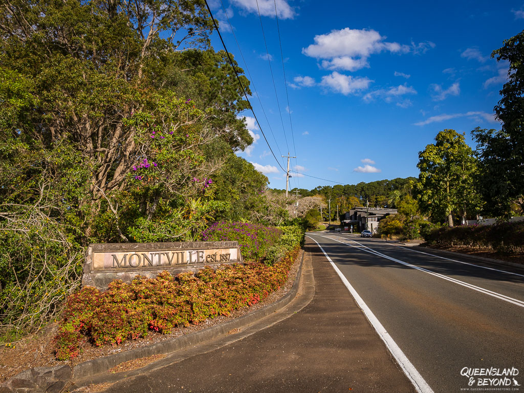
Montville is just a bit too touristy for my liking, which is why I really enjoy Maleny .
It’s got a bit more of a locals’ feel. From Montville, it’s about 16km to Maleny and the drive could be done in 15 minutes. I always seem to dawdle too much though and never get there in under 40 minutes.
Maleny has this incredible gluten-free gelato-selling Maleny Food Co. store , which obviously helps strengthen my conviction that Maleny is the best of the three towns! 🙂
But it’s also got a fabulous main street with some cute cafes and indie shops that sell anything from new & used books, clothing, antiques to gorgeous timber knickknacks, and overall just feels like a real town.
From there, you could head back to Landsborough, a fairly laid-back town, and call it a day.
2. TAKE A SHORT WALK
If you’re keen to stretch your legs a bit, there’s more than enough hiking in the Blackall Ranges to keep you busy for a day.
For an easy stroll through rainforest and dry forest, try the Wompoo Circuit (1.3 km) in Mapleton Falls National Park not far from Mapleton. Most people just walk the 50 m to Mapleton Falls Lookout but you can’t really see the falls so don’t expect too much. The views into the valley are quite nice though.

For a longer walk, try the Kondalilla Falls Loop (4.7 km) in Kondalilla National Park (between Mapleton and Montville).
This hike offers picturesque valley views, rainforest, a swimming hole and a gushing waterfall, especially if we’ve had some rain. Expect mozzies and lots of people, it can get very busy, especially on weekends.

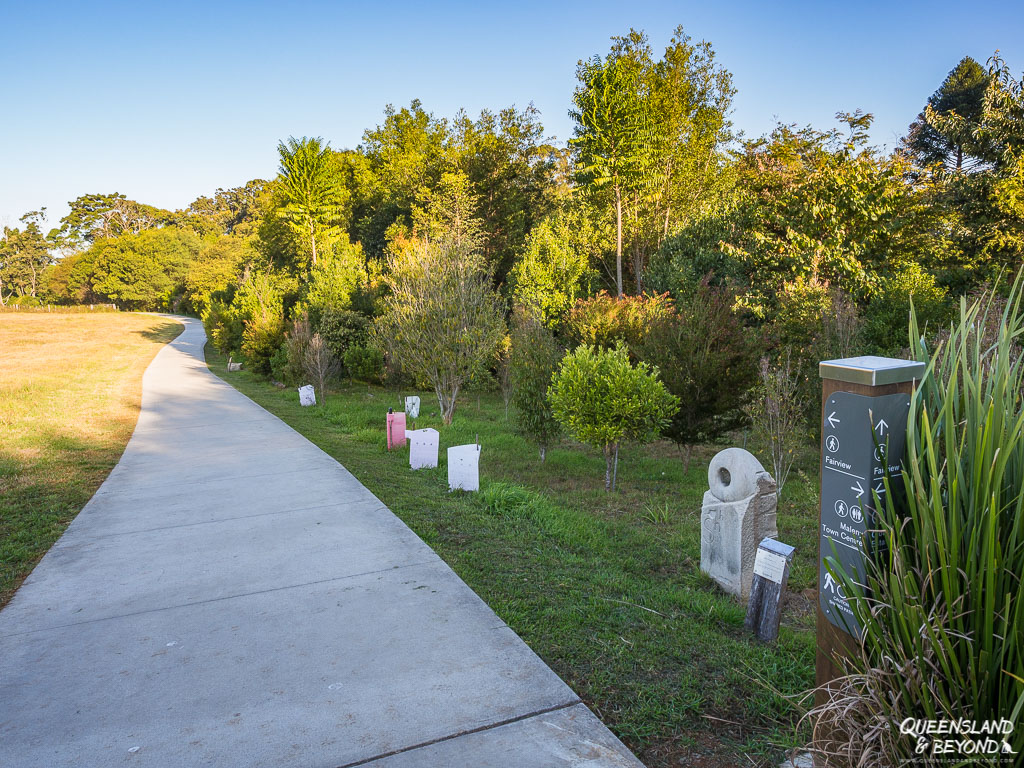
If you’re in Maleny, you could try the Maleny Trail , which takes you on a meander through the town and beyond.
Or head to Gardner’s Falls , at the end of Obi Lane South (off Landsborough Maleny Road). There’s a very short walk to a mini cascade and a rock pool that’s quite popular (but not among my favourite spots).
For one of the best rainforest walks on the Sunshine Coast, stop at Mary Cairncross Scenic Reserve on your way to Landsborough (along Mountain View Road). We always take visitors here, it’s just such a nice spot.
There’s a huge picnic area, a café that serves lovely gluten-free (and non-gf) food, an education centre and a rainforest walk that’s less than 2 km.

3. ENJOY THE VIEWS ACROSS THE BLACKALL RANGES
If it’s hot or you’re just not that keen on hiking in the rainforest, you could just stop at the various lookouts. There are plenty.
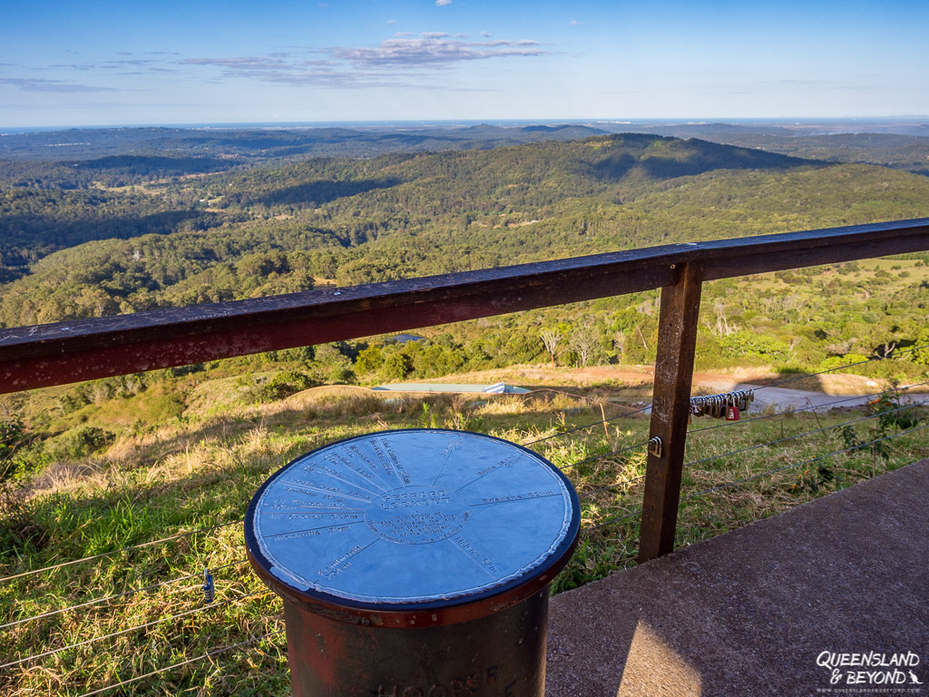
One of the best ones, especially on a clear winter day, is Dulong Lookout , which gives you fine views over the sprawling coast coming from Nambour.
Another one that’s great to stop at is Gerrad’s Lookout , some 7 km south of Montville on the way to Maleny.
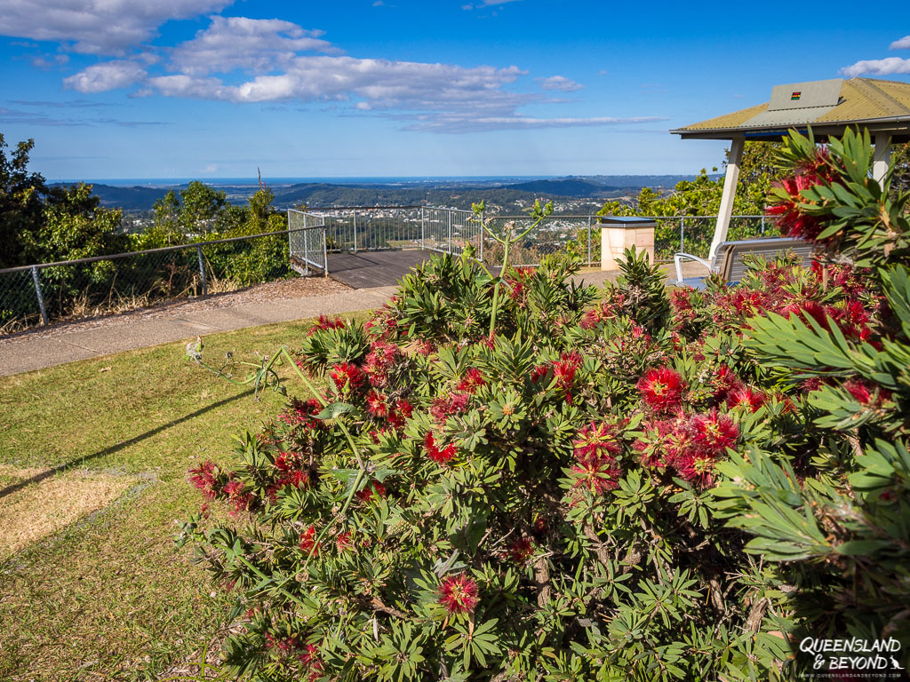
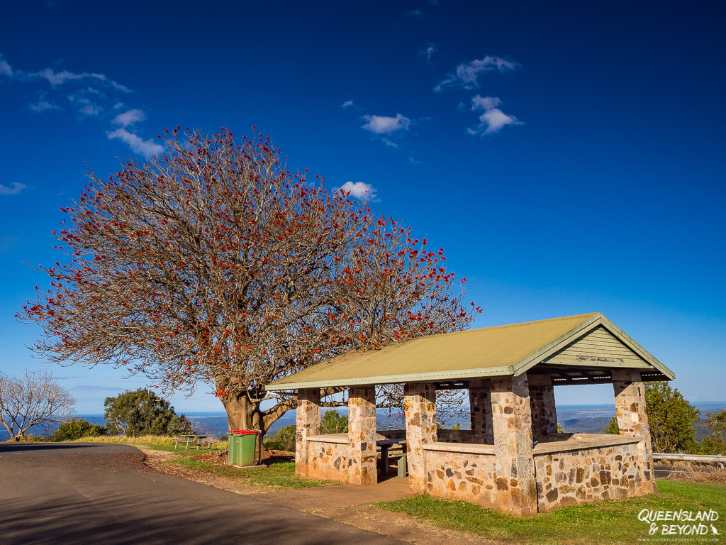
I really like Balmoral Lookout because there are some beautiful trees that come to life in winter and blossom bright red.
This lookout also offers picnic tables and would make for a great lunch spot (if you don’t mind the road noise).
McCarthy’s Lookout offers stunning views over the Glass House Mountains along Mountain View Road near Maleny.
Alternatively, you could stop at Mary Cairncross Scenic Reserve because the views from the upper deck of the education centre are pretty neat. Winter (and morning) is best as there is much less humidity in the air and you might even see Brisbane in the distance.

4. EXPLORE SOME SUNSHINE COAST ATTRACTIONS
This is something we haven’t much done yet, I mean, we’ve only lived on the Sunshine Coast for almost 10 years so what’s the hurry… 😉 But there are a few (paid) attractions that are probably worth visiting on an outing to the Blackall Ranges.
You could visit the Maleny Botanic Gardens , which are a little on the pricey side admisson-wise and weren’t quite looking their best in spring 2022 (still recovering from our terrible weather in 2021 and 2022). But I do love wandering around gardens and photographing flowers, and they have lots of benches and shelters, which make for great picnics with gorgeous views.
And you can BYO your own picnic delicacies, which certainly works for me!

Just FYI, if you just want to see the gardens and not the aviary, it’s much cheaper. We certainly skipped it.
If you’ve ever wondered how a dairy farm works, Maleny Dairy offers guided tours (temporarily closed) . I really want to do this! 🙂
If cheese is more your thing, you could stop at the Maleny Cheese store and café (open Wednesdays-Sundays) for some yummy treats.
MORE IDEAS ON WHAT TO DO ON THE SUNSHINE COAST
Another scenic drive on the Sunshine Coast is the Glass House Mountains tourist drive with some pretty cool views of the volcanic outcrops that are the Glass House Mountains. The official drive isn’t that much to shout about but I’ve written up a little loop tour you could do.
If you’re after some close-up coastal views, check out my guide to 11 Sunshine Coast Lookouts that offer beach views or why not go on a short walk .
Alternatively, go on a day hike , there are some beautiful spots on the Sunshine Coast.
While you have to pay for the Maleny Botanic Gardens, the Maroochy Bushland Botanic Gardens are free, and include a great kids’ corner walk full of Aussie animal sculptures. Totally entertained me!

Further Reading...

Quick Dash through Wongi State Forest and a Visit to Maryborough

Driving the German Alpine Road But Not Seeing Much

A Snapshot of Stunning Kananaskis Country
Road trip australia: 20 routes for your next journey - birdgehls.
[…] Queensland’s Sunshine Coast may not offer epic road trips but there are plenty of gorgeous scenic drives around. And one of the best local road trips is the Blackall Range Tourist Drive. […]
Mudjimba QLD – Tagalong22
[…] attempted to complete the Hinterland tourist drive known as the Blackall Tourist Range Drive #23 which is a total return trip of 114kms (click for Google’s route map) but after […]
3 Sunshine Coast Road Trips You Will Love | Alex on the Map
[…] Range Tourist Drive, as the name suggests, is a route that’s immensely popular with tourists. You don’t have to drive this route, you can cycle it too. There are plenty of places where you […]
Directions to Maleny - Maleny Life
[…] For other items of interest in the Blackall ranges, visit Queensland and Beyond. […]
Leave a Reply Cancel Reply
Save my name, email, and website in this browser for the next time I comment.
Back to Medieval Times: Visiting Burg Rheinfels
An in-depth guide to mount moffatt (carnarvon national park), queensland & beyond.


4 Days in Yamba Itinerary
Yamba truly has something for everyone with its pristine beaches, stunning waterways, and laid-back vibe..
Whether you’re a beach lover, an avid surfer or a keen angler, this charming town is sure to captivate you with its natural beauty and endless activities. Join us for a four-day family-friendly itinerary as we showcase some of the best that Yamba has to offer, from its gorgeous beaches and estuaries to its vibrant food scene and unique shopping experiences. Soak up the sun, feel the sand between your toes, and immerse yourself in the relaxed coastal lifestyle – it’s all waiting for you in Yamba.
Yamba on Yaegl Country
Welcome to Yamba, and welcome to paradise! On arrival, check in to the Blue Dolphin Holiday Resort , where the fun can begin.
After you’ve settled in, walk to town and head to Yamba’s Main Beach , where it’s time to relax and enjoy this kid-friendly sheltered beach and its iconic Ocean pool . There is a great café here, The Kiosk , which is way fancier than just chips on the beach. Think acai bowls, healthy smoothies, and smashed avocado on toast. The kids will love having food options quite literally ON the beach.
After a morning of sandcastle building and jumping waves, grab a takeaway lunch and head to the Blue pools in Angourie . Pop down a picnic blanket and enjoy the serenity as you surround yourself with the old rock quarry.
Fun fact: Legend has it, the pools were formed totally by mistake when a freshwater spring was disturbed in the quarry, transforming it into an aquatic haven. The kids will love exploring the pools, the braver will jump from the rock wall, or while the littlies explore the rockpools with the many sea creatures that inhabitant them.
Head back for a siesta at the Blue Dolphin Holiday Resort and enjoy the kids-friendly facilities it offers, such as kids’ pools, kids’ game areas, and a new scooter track.
In the afternoon grab a few bikes from the resort and head into town, taking in the news from the bike-friendly Yamba break wall (where the Clarence River flows into the ocean). You may spot dolphins here that frequently visit the river mouth and follow the trawlers for their afternoon tea. There’s a life!
Head over to the famous Lighthouse and enjoy panoramic views over the ocean.
Time for dinner? Enjoy a lovely meal at Sassafras , a large family-friendly Pizza restaurant near the main street. It’ll be hard to choose between their famous Yamba Prawn pizza or pasta dishes made from locally sourced produce, but please do yourself a favour and get the rat baits as you peruse the menu, freshly baked bread balls with a selection of homemade butters… Yum!
On your way home to the Blue Dolphin you will pass Yamba Icecreamery where you’ll find a huge selection of homemade ice creams and sorbets made from local produce. It would be rude not to right? Just save room for some Ferrero Rocher flavour for us, please.

Iluka on Yaegl Country
The best (and most fun) way to reach Iluka is by ferry from Yamba. A scenic 45-minute passenger ferry ride will take you across the Clarence River in style. If you choose to go on a Sunday, don’t forget your dancing shoes, as the Sunday Cruise offers live music from one of many local bands/artists. And no, its not karaoke so put your microphone away!
Bring the kid’s scooters along and enjoy a 25-minute stroll/scooter along the river to the charming seaside town of Iluka . There happens to be an awesome playground on the river along the way, which will be a great stop for the kids to run around on the way to town.

Grab a coffee in downtown Iluka, while here stroll the quaint shops and discover Iluka Emporium – An eclectic art space featuring distinctive local art, upcycled objects, books, and collectibles.
After an energising coffee and morning tea from Freshwater Kitchen located in town head over to the incredibly peaceful Iluka Nature Reserve & Bundjalung National Park (stop at the local bakery in town to stock up on some lunch supplies for the hike) – immerse yourself in a 1.5 hour return walk through an ancient forest which just happens to be one of the oldest established forest in the region. The kids will enjoy looking out for all wildlife, listening for the bird calls, and finding interesting tree branches that twine around each other.
At the halfway point, you reach Iluka Bluff to catch the spectacular 360-degree views out over the coast and inland forest. Unpack your picnic lunch and enjoy rest time, either on the grassy headlands or right on the beach before ending back the way you came.
Once back in Yamba (after returning on the ferry), head to Yamba Bowlo for some mini golf, ten pin or to watch the kids attempt the climbing wall. Or if golf is your thing, head over to Yamba Golf club for some dinner and your chance to claim glory on their brand new virtual golf simulator.
A short walk home to the Blue Dolphin where you’ll spend the night preparing for another fun packed day tomorrow.
Maclean on Yaegl Country
While Yamba has everything you need for an action-filled holiday, the Clarence Valley has lots of great towns you’ll want to explore while you’re here. So today, we’re heading out and about. A 30-minute drive out of Yamba will take you to the Scottish-inspired town of Maclean . Notice all the Tartan-Painted Power Poles? Pick up a map from the Scottish Shop and try and find your Scottish name and tartan. Don’t worry if you don’t have Scottish Heritage, just adopt the tartan you like best and Scottish name for the day.

While you’re in town, head on up to the Maclean Lookout for spectacular views of the Clarence Valley. Look over the valley from the viewing platform and spot The Pinnacle, a unique rock formation surrounded by subtropical rainforest, and an important Aboriginal Cultural Heritage Site. In fact, Maclean lookout, or The Giant Serpent, is the number 1 stop on the Lower Clarence Aboriginal Tourism Site Drive, the first project of its kind in Australia. You can learn the importance of Aboriginal Culture and 13 Yaegl significant sites from Maclean to Yamba.
Do you smell that roasted coffee? Follow your nose and find Botero where coffee roasters perform their weekly ritual of perfecting the best possible coffee combination in-house. Enjoy outdoor seating with an adjacent playground or perhaps the kids will love the Lego room. Quite literally, a room full of white Legos.
Lawrence on Yagel County
From Maclean, drive across the McFarlane Bridge onto Woodford Island to head to Bluff Point Ferry. Fun Fact (in case the kids are keeping track) Woodford Island is the largest island in NSW.
Take the famous Bluff Point Ferry, known fondly as the Lawrence Ferry, which will carry you calmly across the Clarence River to Lawrence . In true country town style, there is no timetable and no fees, and the ferry operates 24/7. What an adventure. Fun Fact #581: there are only 11 car ferries left in NSW!
Head down to the local playground complete with bike tracks and flying fox, you may have to drag the kids away eventually to get a move on. Try to bribe them with ice cream from the General Store across the road. It may just work.
Grafton on Bundjalung country
From Lawrence drive Tourist Drive 22 which follows the river all the way to the historic town of Grafton . Pop down to the Grafton Regional Gallery and get inspired by word class exhibitions – grab lunch at the stunning courtyard at Rubony’s café at the Gallery or take part in one of the many workshops that are held here, especially during school holidays.
After lunch stroll down to Grafton’s main street and admire the historic buildings, it’s like walking back in time. You may have to answer some interesting questions from the kids on what each building is so make sure you pick up the Grafton Heritage Trail brochure from the at the Regional Gallery while you’re there.
If it’s raining and someone (usually dad) forgot his umbrella again, just catch a family movie at the Saraton Theatre instead. This theatre dates back to 1925 and is simply stunning. The kids will love the old charm feel and a movie with a choc top of course. This theatre is licensed, so mum and dad can grab a drink while here too.
As you head back to Yamba, just imagine the fresh prawns you can pick up from the local Fishos for a quiet evening in the holiday park, peeling prawns and taking in one of the famous Yamba sunsets. What a perfect end to a fun-filled day.
If there is one phrase you’ll hear a lot around here, it’s “You’re on Yamba Time”. The giant clock on Coldstream Street, the one outside Wobbly Chook Brewery doesn’t even work and is for decoration only, time stands still quite literally. You are on Yamba Time now which basically means you have the freedom to take your time, take it all in, and take each moment at a time.
When your biggest decision today will be which beach to take the kids to. Whiting Beach , where the river is calm and perfect for paddle boarding or little legs who don’t like waves. Turners , where you’ll find surfers and body boarders putting on a show for people walking the break wall. Pippi , where you can take the dog to the South, or catch waves in the North. Or maybe even Convent , a lesser-known hidden beach, the local’s favourite where you’re pretty much always protected from the wind, enjoy shade from the Pandanus trees, and can find a nice quiet spot to relax. Wherever you end up, take some snacks because the kids will need the energy after all the swimming and shell searching.
Learn about Yamba’s history and take a tour of Yamba Museum , where the kids are on the hunt for hidden mice (no actual mice were harmed in the making of this quirky treasure hunt).
As you walk through town, check out the boutique shops and popular cafes where you can decide if it’s time for morning tea, brunch, lunch, afternoon tea, or all combined! You’re on Yamba time remember!
The newly upgraded skate park , complete with a huge clover bowl, is the key attraction for kids under the age of 80. From behind your hands, you can watch as the kids take on the half pipes and other obstacles that test their fear and your patience!
Let the day come to an end by catching yet another spectacular sunset in this perfect little town, creating family memories for years to come. We’ll see you again soon just like so many other families generation after generation. Yamba is home now.
While you’re here, don’t forget to tag us on your adventures at #myclarencevalley!
THINGS TO DO
The great outdoors, a place to stay, eat, drink & be happy.
- LIST YOUR EVENT
- MOVING HERE
- ©2024 My Clarence Valley
- Privacy policy
- terms and conditions
- SITE BY WISDOM
Event Calendar
Moving here, trip planner.

M-22 Road Trip: a scenic drive along the Lake Michigan shoreline
With dramatic views across Lake Michigan, M-22 is one of the state's most famous scenic drives, with picturesque shorelines and beautiful countryside all along the route. Beside the stunning scenery, you'll stumble upon quaint towns along the way, including charming Manistee and historic Frankfort.
It takes 2 hours 50 minutes to drive the scenic M-22, following the shore of Lake Michigan for 120 miles through Manistee, Arcadia and Frankfort to Traverse City or start in Chicago for a 7 hour 20 minute, 390-mile trip via Indiana Dunes and Holland.
During fall the striking greenery turns vibrant red and brown, making it a wonderful time to drive this scenic Michiganroad. M-22 was even voted 'Best Scenic Autumn Drive' back in 2015, so keep on reading to find out what makes it such an amazing drive whatever time of year you visit.
Where is M-22?
The whole length of M-22 is in Michigan, following a stretch of the Northeastern shore of Lake Michigan. It passes through small fishing towns and villages such as Manistee, Onekama, Frankfort, Lake Township, Leland, Northport and Traverse City.

The scenic road offers beautiful lake views throughout the drive, but there are also some amazing natural wonders that you'll pass, including Arcadia Dunes, Crystal Lake, Glen Lake, West Arm Grand Traverse Bay.
Where does M-22 begin and end?
Manistee, on the shore of Lake Michigan, is where the scenic drive along M-22 begins.
This small town, located 265 miles out of Chicago, is famous for its picturesque views, historic downtown, and also as a gateway into Huron Manistee National Forest.
M-22 runs right the way up to Traverse City, which is also in Michigan. Looking out over the West and East Arms of Grand Traverse Bay, it has fantastic freshwater beaches. It's also known as the Cherry Capital of the World!
How long is M-22, and how long will it take to drive the entire M-22?
M-22 itself is about 120 miles long, including the short distance you'll need to travel along other roads to get all the way from Manistee to Traverse City, Michigan.
You can cover this distance in around 2 hours and 50 minutes if you don't make any stops, meaning you could easily complete the round trip in half a day.
Many travellers will make their way from other cities in the region. One of the most popular is Chicago, which is 265 miles away from Manistee. If you start your trip from the Windy City then the one-way drive via M-22 to Traverse City is 390 miles long.

With a driving time of 7 hours and 20 minutes, you'll probably want to stop at least once on your drive from Chicago. With so many amazing views to admire along the way, we'd suggest taking your time so that you can really appreciate this amazing part of the world - a night or two by the lakeshore makes the perfect scenic getaway.
Best way to drive M-22
Driving the full 120 miles of the M-22 allows you to see the scenic road in its full glory. You'll ride along the eastern shores of Lake Michigan then turn along the western side of Great Traverse Bay before reaching your destination.
As you'll be following this one road almost all the way, it's pretty simple to navigate this route so you can give all your attention to the stunning beaches, lush forests and quaint towns you'll pass.
M-22 is still considered something of a hidden gem, so heavy traffic isn't usually an issue. Along the way, you're sure to find a secluded spot to pause and admire Lake Michigan.
If, like many travellers, you're starting your trip from Chicago, you'll find that the route via Interstate 90 (I-90) and I-94 is pretty straightforward. As an added bonus, you'll be able to enjoy the southern shores of Lake Michigan along the way.
As well as nature spots and sweeping lake views you'll pass through charming towns like Holland voted 'America's Prettiest Town' not too long ago.
Driving the entire length of M-22
Leave Manistee on Route 31, heading toward the airport. A little way out of town you'll take a left turn just after Little River to pick up the start of M-22, this scenic drive that you'll be following for the next few hours.
This will take you north, swinging round the shore of Portage Lake before carrying on through Arcadia and Green Point Dunes.
Next, after crossing Betsie Lake, you'll reach Frankfort where you can stop to explore this charming historic town. From here the road hugs the shore of Lake Crystal and carries on through Empire and Glen Arbor.
Follow the road around Good Harbor Bay then up past Clay Cliffs Natural Area to Northport, where you'll change direction and start heading south along Great Traverse Bay.
From Sutton Bay, the road cuts inland for a couple of miles before you begin the final, stunning stretch along Great Traverse Bay into Traverse City.
Driving M-22 from Chicago to Traverse City
Head east out of Chicago on I-90 then merge onto I-94 near Portage. The interstate will take you past Indiana Dunes National Park then on into Michigan, where you'll change onto the I-196 a little way past Benton and St Joseph.

Follow I-196 along the shore of Lake Michigan until you reach Holland, where you exit onto Highway 31 to continue north. The highway will take you all the way to Manistee to start the scenic part of this drive, passing through Grand Haven and Muskegon along the way.
Best places to stay along M-22
You can drive the length of M-22 in a single day, but with such a beautiful landscape to explore many travellers choose to stay a night or two while they make the drive.
Empire, Michigan
Whether you're travelling from Manistee or all the way from Chicago, a great place to spend the first night of your trip is the coastal small town of Empire.
The Empire Lakeshore Inn in Empire, Michigan , offers a delightful combination of charm and convenience, making it a favorite among guests.
Nestled in a picturesque location, the inn boasts modern and clean rooms. The proximity to the beach and a local bar/restaurant adds to the allure, providing guests with easy access to leisure activities and dining options.
The Empire Lakeshore Inn serves as an ideal base for exploring the stunning Sleeping Bear Dunes National Lakeshore, renowned for its natural beauty. The inn's location ensures that guests are never far from the best sights and experiences that Empire has to offer.

The friendly and welcoming staff at the Empire Lakeshore Inn receive consistent praise from visitors. Their attentiveness and local knowledge enhance the stay, making guests feel at home and well-informed about the area's attractions and activities.
For activities outside the inn, guests recommend a visit to the nearby beach, which is just a short walk away. The beach offers a tranquil setting for relaxation and enjoying the natural beauty of Lake Michigan.
Additionally, exploring Sleeping Bear Dunes and indulging in the local dining scene are highly recommended to complete the Empire experience.
Traverse City, Michigan
Once you reach the end of your M-22 drive, kick back and relax with Traverse City, where you'll find a great range of outdoor activities to enjoy. The climate and terrain also lend themselves to viticulture, so you'll find a number of wineries in and around the town.
Several of the vineyards and wineries are open to visitors. Famous establishments where you can have taste of the local wines include Bowers Harbor Vineyards, Mari Vineyards, Chateau Chantal Winery and Brys Estate Winery.
Downtown Traverse City is on the shoreline of the west part of Grand Traverse Bay, and when you walk along scenic Front Street you can visit stores, galleries and restaurants. Don't forget to visit Cherry Republic for cherry related products while you're in the Cherry Capital of the World!
Also on West Grand Traverse Bay is Clinch Park, a popular spot with sandy beaches - bring a picnic and enjoy a scenic lunch. Nearby, the renovated historic site of The Village at Grand Traverse Commons now offers shopping, fine dining, gardens, and spa treatments.
Tamarack Lodge offers an ideal blend of comfort and natural beauty , making it a superb choice for a road trip stopover. The well-equipped kitchens in each suite allow for the convenience of home-cooked meals, adding a touch of homeliness to your travels.
The accommodations are spacious, suitable for families or groups, and provide stunning views of the surrounding area. The lodge's location by the lake, with its private beach, offers a serene escape and opportunities for relaxation and outdoor activities like walking tours and billiards.

Tamarack Lodge's proximity to local attractions such as the State Park Beach and the Dennos Museum Center offers a blend of cultural and recreational activities. The shared fire pit and barbecue facilities at the lodge further enhance the outdoor experience, making it a memorable part of your journey.
Things to see on a road trip along M-22
Most travellers are immediately attracted to the road trip along M-22 by the fabulous lakeshore views, but there are plenty of other attractions that make this drive the perfect pick for a scenic road trip.
Things to see on the road trip from Chicago to Manistee
- Gary, Indiana - Go to Marquette Park and see the 1921 Pavilion next to the lagoon and Lake Street Beach.
- Indiana Dunes National Park, Porter - Indiana Dunes is a 15,000-acre National Park next to the Lake Michigan shoreline. You can explore the dunes, prairies, rivers and forests on the 50 miles of hiking trails.
- Michigan City - Immerse yourself in the forest and streams at Trail Creek and take photographs at the Michigan City East Light.
- South Haven - Stroll the picturesque Van Buren State Park with 1-mile-long tranquil beach. There are campgrounds, picnic tables and grills waiting.
- Holland - With its historic charm and cobblestone sidewalks, pretty Holland has been voted America's Prettiest Town, so it's the perfect place to stop and explore.
- Grand Haven - Visit this graceful small town between May and September to see the Grand Haven Musical Fountain, which performs synchronized routines at dusk.
- Pentwater - You'll find stunning beaches in Pentwater, where you can join in on a yoga class on the Charles Mears State Park beach in the summer.
- Ludington - Step back in time to pioneer times at the Historic White Pine Village. The village includes an original 1849 County Courthouse and a working sawmill.

Things to see on the M-22 between Manistee and Traverse City
- Manistee - Spend a few hours in the Manistee Historical Museum to learn more about the town, then go fishing on the Manistee River or enjoy the Orchard Beach State Park.
- Captain John Langland Park, Onekama - For a secluded beach walk, go to Captain John Langland Beach. You can park 90 yards from the water.
- Arcadia Dunes - Follow the Overlook Trail to look over Lake Michigan from a new perspective.
- Sleeping Bear Dunes National Lakeshore - The sand dunes here are huge and walking up the dune climb is a strenuous hike. For more accessible views, ask a ranger at the Philip Hart Visitor Center.
- Glen Lake, Glen Arbor - Hire a boat or pontoon and spend a day on the inland Glen Lake. Surrounded by dunes and forested hills, it's a scenic day on the clear waters.
- Nedows Bay, Leland - Canoe and kayak at Nedows Bay. A family-friendly beach it's a popular stop in the summer months.
- Clay Cliffs Natural Area, The Leelanau Conservancy - Take a hike through forest terrain to the viewing platform. You'll see Lake Michigan to your west and Lake Leelanau to the east.
- Omena - Taste the local wines at Leelanau Wine Cellars and Tasting Room. They'll offer free samples as you overlook the Grand Traverse Bay.
- Suttons Bay - Before arriving at Suttons Bay, try your hand in Leelanau Sands Casino. Then visit Suttons Bay with its wealth of wineries and restaurants.
- Boughey Park, North Traverse City - Boughey Park is a small and quiet beach. There are seating areas and picnic tables on the waterfront.
Best time to visit M-22
Michigan has warm summers followed by harsh winters which bring freezing temperatures with snow and ice. This means that, depending on the time of year, your driving experience along the M-22 will vary.
In summer, temperatures seldom exceed 80 degrees Fahrenheit or fall below 55 degrees, so although it's not excessively hot, the weather sees people flock to beaches to enjoy water-based activities. June, July and August are the hottest months, and also when the beaches near M-22 are busiest.

In contrast, from November through to February you'll experience extremely cold conditions. Temperatures can drop as low as 18 degrees Fahrenheit.
Snow is common from December to February, but it's rare for it to cause closures on the M-22. With fewer visitors to the beaches, you're likely to have a quieter journey in winter. However, this also means that some shops, trails and smaller roads may not be open during winter months.
Thanks to the M-22 being coined the 'Best Autumn Scenic Drive' fall is actually the most popular time to drive this route. To see the foliage changing color in spectacular style, visit mid-October.
September and October have an average temperature of around 60 to 50 degrees Fahrenheit, so it isn't too cold and it's comfortable enough to hike the trails.
Fast forward to spring and March remains cold, with temperatures averaging around 35 degrees Fahrenheit, but by May that rises to 55 degrees Fahrenheit.
Spring is a great time to visit because the greenery comes to light and many open businesses open their doors after winter closures. If you're making this road trip in May, you will catch the Annual Tulip Festival in Holland.
Whatever time of year you visit, you can be sure to come home with unforgettable memories of the ever-changing Lake Michigan shoreline, which makes for a beautiful drive in all seasons.
Join our email list!
By joining our email list, you give LazyTrips permission to use your email for sending you newsletters, emails and updates including for marketing purposes. Your email will not be provided to third parties.
Related posts

File : Australian Tourist Drive 22.svg
File history, file usage on commons, file usage on other wikis.
Original file (SVG file, nominally 501 × 501 pixels, file size: 13 KB)
<<< >>>
Click on a date/time to view the file as it appeared at that time.
You cannot overwrite this file.
There are no pages that use this file.
The following other wikis use this file:
- List of road routes in Victoria (numeric)
- List of road routes in New South Wales
- List of tourist drives in Queensland
- Gympie–Brooloo–Kenilworth Road
- Blackall Range road network
- Eumundi–Noosa Road
This file contains additional information such as Exif metadata which may have been added by the digital camera, scanner, or software program used to create or digitize it. If the file has been modified from its original state, some details such as the timestamp may not fully reflect those of the original file. The timestamp is only as accurate as the clock in the camera, and it may be completely wrong.
Structured data
Items portrayed in this file, 17 november 2013, image/svg+xml, e720910a8d404a9edf4d533065258db9a62ce643, 13,043 byte.
- Diagrams of Australian tourist drive signs
- Unchecked SVG validity
- PD ineligible
Navigation menu
Tourist Drive 33

- 1.1 History
- 2.1 Climate
- 2.2.1 Payphones
- 2.2.2 Mobile phone signal
- 4.3 By train
- 4.4 By bike
- 5.1 Hornsby to Calga
- 5.2 Calga to Glenworth Valley
- 5.3 Glenworth Valley to Bucketty
- 5.4 Bucketty to Wollombi
- 5.5 Wollombi to Cessnock
- 5.6 Cessnock to Branxton
- 5.7.1 Wineries in Broke
- 5.8 Cessnock Bypass
- 5.9 Big Yango Loop Trail
- 5.10 The Wattagans
- 5.11 Mangrove Dam Trail
- 5.12 Other tracks
- 6.1 Road closures
Tourist Drive 33 is a major tourist drive from Calga in the western part of the Lower Central Coast to Branxton in the Hunter Valley, the second longest tourist drive in New South Wales , the second most promoted tourist drive in New South Wales and the longest interior tourist drive in Australia that's not in Victoria.

Understand [ edit ]
No other place in the Australia continent has long interior tourist routes as well situated as this one - either the views, access, wineries, the length and variety of environments or their historical significance pale in comparison. To travel from either Gosford or Hornsby along this route, even only in sections if restricted by time or budget, is a memorable experience.
Glenworth Valley and the Hunter Valley Gardens are situated along this route, making it one of the most heavily used tourist drives in Australia along with the Grand Pacific Drive or Great Ocean Road (B100) .

For a route to be classified as a Tourist Drive or Tourist Route in New South Wales, each drive must go through nomination process, it could be promoted to a tourist drive. However, in the early 2010s, 12 of around 70 tourist drives in New South Wales were decommissioned - meaning they lose their status, however, Tourist Drive 33 was one of their first tourist drives declared in the 1960s - and it's one of the few Tourist Drives that are still standing today that were declared in the 1960s, better than it originally was with much more side trips and more places to see.
If you wanted to go directly via the Pacific Motorway and B82, then it will take about 2 hours to go from Sydney to the Hunter Valley, but using this route will probably take 2.5 hours non-stop without traffic. However, you'd want to take at least 2 nights to fully explore this drive, into detail and not missing out on the best aspects of this drive and if you want to explore every single aspect of this drive, then it'll take a week.
History [ edit ]
Parts of this route were built by convicts in the early 1800s to connect Sydney to the Hunter Valley. Construction of the Great North Road began in 1826. It was considered one of the greatest engineering records for the early 19th century.
The Great North Road is 240 km long, and parts of it are part of Tourist Drive 33. Most of the road is used today as an alternate way to get to the Hunter Valley, and is also the scenic route.
Much of the 240 km of the Great North Road has been renamed, such as to Wisemans Ferry Road , Old Northern Road or Old Great Northern Road ; however, the original name is still used on the section between Mogo Creek and Wollombi. Meanwhile in Sydney, the Great North Road in Five Dock/Abbotsleigh was also once part of the same road.
The Great North Road was not a continuous road for 240 km. Occasionally, there were ferries and parts of it was split. To this day, some parts of the road are not connected and there are some ferry crossings (e.g. Wisemans).
Regardless, the road was an iconic architecture and engineering feat for the 19th century. Some parts are scenic, too. The sandstone formations, which can still be seen in some parts, are an icon of the drive.

The modern-day Great North Walk had also origins from this route. The 200-km Sydney to Newcastle road passes through some of this route — mainly the route of the Great North Road.
Prepare [ edit ]
There are parts of the drive that have no mobile signal. You will most likely need to carry a satellite phone . It can get mildly windy in parts, especially in those on the higher altitudes of Mangrove Mountains. In some areas, especially in Glenworth Valley, there are so many flies that you will almost certainly want to carry an insect repellent.
The next question is if you want to drive the whole way on the road, or stop and enjoy a kayak or horse ride at Glenworth Valley or see some flora and fauna at Hunter Valley Gardens. This will almost certainly come down to time. A simple trip along the road can be quite time consuming. For example, from the Hornsby city centre to the Hunter Valley Gardens can take up to 3 hours on the road non stop. There are other direct routes you can take to get you there faster without going on the winding scenic road like the M1 Pacific Motorway on the east and the M15 Hunter Expressway to the north.
You can do the road in a long day starting quite early from Hornsby and finishing the loop back quite late. If you do so, make sure you are road tripping with someone, or a group of you who can share the driving. There are also options in staying in one of the villages or Glenworth Valley, Peats Ridge, Wollombi or the Hunter Valley along the road and breaking the trip in multiple days.
Climate [ edit ]
The climate of most of the drive varies from very hot to somewhat cool. In summer, the weather can get to a scorching 40˚C, while in winter temperatures can get very cold compared to the rest of New South Wales and drop to 12˚C. There is also has a wet spring season when the drive can be slick. Autumn is usually the milder, dry season, bringing 30°C highs, blue skies and the bulk of tourists.
Snow can be a problem in Wollombi in the winter, however snow is very rare and only occurs 1 in every 10 years. However, it is always a good idea to check the weather and forecast before going as rain can also affect the journey.
Phone coverage [ edit ]
Payphones [ edit ].
Payphones are scattered throughout the drive, but some on the street side in some towns (particularly Wollombi and Cessnock) suffer from vandalism and may be inoperable. It might be best to try the one at your hostel or at the tourist centre. Phones are coin-operated or use prepaid phonecards, available from most supermarkets or newsagents. International calling cards are also available at these outlets.
There are also emergency phones on the drive, approximately every 10-20 km.
Mobile phone signal [ edit ]
Mobile phone coverage can be sketchy. The Telstra networks have a good signal within towns, becoming variable to non-existent especially on the Mangrove Mountains to Wollombi. Other networks like Optus and Vodafone are hit and miss, but those with 3G/NextG phones might have more luck.
Get in [ edit ]
There are multiple starting points, depending on where you wish to begin the journey.
However, there are 3 commonly used entries on Tourist Drive 33 and these are generally the best ways. One is down south on the M1 near Calga, the second one is the B82/B68 junction at Cessnock and the third one is at the M15 near Branxston, at the very north of the drive. There are other entries too, but these three are the most common ones. Once you're in, just follow the brown Tourist Drive 33 signs.

Get around [ edit ]
By car [ edit ].
This drive can be easily achieved as long as you have a car. Distances are long, steep and without a car, it is virtually impossible to accomplish.
This route is best done in a 4WD or an SUV. Sedans and caravans can't do some of the very steep climb on the side tracks. Make sure the car your bringing is less than 10 years old, as some of these tracks erode quickly after frequent rains in this area. Some sedans and caravans are also not suitable navigating the sharp bends, especially the climb up to Wollombi. If you don't have a car, then car hire is available at the following places:
In Gosford and the Lower Central Coast at the nearest train station
- -33.419876 151.343224 1 Avis Australia (Gosford) , 322 Mann Street, Gosford, 2250 ( This isn't exactly on Tourist Drive 33, but it's in Gosford, at the closest train station to Calga ), ☏ +61243232222 . ( updated May 2021 )
- Thrifty Car & Truck Rental Tuggerah , 144 Pacific Hwy, Tuggerah, 2259 . ( updated May 2021 )
In Cessnock
- -32.840157 151.356165 2 Hertz Car Rental Cessnock , 1A Aberdare Rd, Cessnock, 2325 , ☏ +61249912500 . M-F 9am - 5pm Sa 9am - noon. Su Closed . 200 metres from the route of Tourist Drive 33. ( updated May 2021 )
By bus [ edit ]
Buses only operate from Cessnock to Branxton for non tourism purposes only. The route doesn't even go here but you'll have to go to Maitland and catch a train (Hunter Line), and which is not what you want here or are expecting.
By train [ edit ]
There are no trains that run directly parallel to this route and trains only stop at Branxton.
By bike [ edit ]
While cycling is possible, it is recommended only for those that can endure long mountainous rides while carrying camping and survival equipment. Spare at least 4 days if you wish to bike all the way and exploring the drive at the same time.
During high winds there are only a few shelters where you can rest but there are trees to at least block some of the wind. There is no separation of lanes between bicycles and cars, ride with care and provide right of way to whoever is driving faster. Helmets must be worn by Australian law and headlights must be on at all times. Make sure to have all the necessary equipment in optimal condition throughout the journey, as there are very few repair shops along the way - only in Branxton , Cessnock and Wollombi . Additionally, be prepared to do some of the windy road run up towards Wollombi. Cars often struggle up that stretch, so enjoy if you choose to bring your bike up.
Fancy a bus ride to take a break from cycling? You're on the wrong road. Buses do not operate on most of the drive; where they do run bikes may not be carried onto buses, although this is at the driver's discretion.
Go [ edit ]
Many visitors will wonder how much there is to see in such a short drive. The answer really depends on your interest.
Sunset and sunrise are the best times to get out and look. Not only are the temperatures cooler, but the quality of light ignites the stone with a luminous orange tone. You're also more likely to see animals that have been hiding from the midday heat venturing out to feed and all the pesty insects would not be here, early in the morning. Not only that but you also see a nice beautiful sunrise and sunset, up on the mountains. Some side routes are not possible to access if you do not have an SUV.
Hornsby to Calga [ edit ]
Speed limit: 110 km/h
Although, this part of the journey is not part of the official gazetted Tourist Drive 33, the journey to Calga is a nice, picturesque drive, passing the Hawkesbury River; a great camping spot or a place to explore for a day. While most people who use this drive use the M1 Pacific Motorway, you can also use the B83 Pacific Highway; a more scenic route and a route for those who want to avoid 110 km/h decently high speed roads which also provides a very different view.
Calga to Glenworth Valley [ edit ]

Along the way:
About the road:
- Speed Limit: 100 km/h (40-50 km/h on Cooks Road)
- Distance: 3 km (plus a 3-km-long drive to get to Glenworth Valley Outdoor Adventures)
- Road surface: asphalt (gravel for 1 km of the 3-km-long route to get to Glenworth Valley Outdoor Adventures and Glenworth Valley in general)
- Roads taken Peats Ridge Road (and Cooks/Popran Road to get to Glenworth Valley Outdoor Adventures)
You do not have to go to Glenworth Valley, however most tourists camp for a night or two and do some of the outdoor adventures out there.
As of May 2021, there are no plans to pave the 1 km of unpaved road, as the road is not owned by the NSW government, so it is very advisable to not go in a sedan, caravan or any vehicle that is not a 4WD or an SUV. There may also be potholes on Cooks Road so again, it is very advisable to go in either a 4WD or an SUV. However Peats Ridge Road is fairly straight with few sharp bends or hairpins.

Things to see or have along the way
- -33.400427 151.206152 1 Glenworth Valley Horse Riding ( Glenworth Valley Outdoor Adventures ), Cooks Rd, Glenworth Valley , ☏ +61 2 4375 1222 . Daily 8:30AM–5:00PM, bookings required. Closed on public holidays . Minimum $80 . ( updated Jan 2021 )
- -33.419528 151.188059 2 Glenworth Valley Kayaking ( Glenworth Valley Outdoor Adventures ), Popran Rd, Glenworth Valley , ☏ +61 2 4375 1222 . Daily 9AM-5:30PM, bookings required. Closed on public holidays . ( updated Feb 2021 )
- You can eat or have a coffee at the -33.402974 151.192812 1 Glenworth Valley cafe . ( updated Mar 2021 ) .
- Glenworth Valley also has an outdoor laser tag, a world first; great if you're an outdoorsy person but also love laser lag, these will however, require bookings.
Sleep along the way
- -33.399324 151.194389 1 Glenworth Valley Outdoor Adventures . GVOA is the only place to sleep at this point in time, and new places opening are unlikely. You can go camping, glamping, stay in a cabin, tent or tipi. Tents and tipi's can be hired there. Bookings required. ( updated May 2021 )
Glenworth Valley to Bucketty [ edit ]

- Speed limit: 60-100 km/h
- Distance: 41.3 km
- Road surface: asphalt
- Roads taken Peats Ridge Road and George Downes Drive
The road is a narrow two lane road with only one lane paved on George Downes Drive. Parts on Peats Ridge have 2 lanes. On George Downs Drive there may be a double lane marker, but it is just a guide for other vehicles passing in the opposite direction. If there is a vehicle coming on the opposite direction; you are expected to go slightly off the paved road to let the oncoming vehicle pass by. After the oncoming vehicle has passed, there may be some dust which can block vision. Also avoid overtaking vehicles on sharp bends, black spots and hairpins.
Additionally, for those who brave the heights, take Brieses Road and Old Mooney Dam trail and explore the Mooney Mooney Dam , and for those who enjoy a nice picnic at the lake, there is the same opportunity except the fact it is the Mangrove Creek Dam Picnic Area which requires a 12.8-km drive from Kulnura, the nearest town. Avoid using this route unless you are going on a 4WD. The road may also be closed during rain or storm.

Along the way, it is also home to -33.221533 151.212621 1 Kulnura One Stop Jerry's Cafe . one of the most famous cafes in the region. ( updated Mar 2021 )
- -33.225125 151.222882 1 Kulnura General Store , Greta Road . The only supermarket in the surroundings, and if your stuck, then this would most likely be your nearest supermarket. ( updated Mar 2021 )
- -33.395238 151.242965 1 Mooney Mooney Dam . ( updated Mar 2021 )
- -33.219359 151.121385 2 Mangrove Creek Dam Picnic Area . ( updated Mar 2021 )
- -33.22605 151.179491 2 Waterfall Springs Retreat , 2394A Kyola Road, Kulnura 2250 , ☏ +61243761185 . Has a swimming pool and a coffee and tea maker in all rooms. Free Wi-Fi and hiking trails nearby. ( updated May 2021 )
- Noonaweena , 1442 George Downes Dr, Kulnura 2250 . Offers an outdoor pool and tennis courts, located on 100 acres of countryside. ( updated May 2021 )
Bucketty to Wollombi [ edit ]

- Speed limit: 60-80 km/h
- Distance: 22.7km
- Roads taken Great North Road
The 19th-century road built by convicts merges here. It is still a narrow two-lane road. However, the road here is not suitable for caravans and large vehicles. You can also drive take a side route and drive across the -33.109944 151.135741 3 Great Northern Road . ( updated Feb 2021 ) towards -33.378657 150.990403 4 Wisemans Ferry . ( updated Feb 2021 ) and -33.293266 150.972492 5 St. Albans . ( updated Feb 2021 ) .

Things to see along the way or at Wollombi In Wollombi, you can also explore the Ngurra Bu; one of the historic and culturally significant Aboriginal sites. Not to worry; if you are the person who'd like to see historic churches St Michael the Archangel's Wollombi Church is a really historic, well preserved church built back when the town was founded in the 1800s.
- -32.918656 151.116865 2 Ngurra Bu . ( updated Mar 2021 )
- -32.937652 151.140825 3 Wollombi Valley Arts Council , 2888 Wollombi Road Wollombi , ☏ +61249988347 , [email protected] . M-Su 10am-4pm . A decently sized art gallery that displays all sorts of Aboriginal Art. ( updated May 2021 )
- -32.938476 151.141738 4 St Michael the Archangel's Wollombi Church . Well preserved historic church ( updated Mar 2021 )
Galleries include:
- Yengo Gallery . ( updated May 2021 )
- Roadside Gallery . ( updated May 2021 )
Wollombi to Cessnock [ edit ]

- Speed Limit: 100 km/h
- Distance: 31.1 km
- Roads taken Wollombi Road

Be aware that traffic can be a nightmare and after 1800 during the summer because of the HVG X-mas light show and during the spring holiday season. Road quality can get no better throughout the Hunter Valley. The exact opposite with Cessnock though however this is due to it commonly flooding.
- -32.88751 151.251492 3 The Old Post Office Millfield , 50 Wollombi Rd, Millfield , ☏ +61418967052 . Who said that post offices are only for the mail? An old post office, now a hotel. ( updated May 2021 )
Cessnock to Branxton [ edit ]

- Speed limit: 80-100 km/h
- Distance: 20.5 km
- Roads taken B82 Wine Country Drive,
Although this route is no longer signed at Branxton, the journey through this part is an amazing experience. Passing through this route from Lovedale to Cessnock is an unforgettable experience that most wine tasters will enjoy. Along the way is also home to one of the Hunter Valley's most famous zoos here.
Things to see along the way
Alternate Tourist Drive 33 ( Wollombi to Lovedale via Broke and Pokolbin ) [ edit ]
- Speed limit: 20-100 km/h
- Road surface: asphalt and gravel
- Roads taken: Paynes Crossing Road, Wollombi Road, Cessnock Road and Broke Road
While this route isn't marked physically, the alternate route still appears on the official tourism maps showing this side route. When going northbound, follow the signs to Singleton (until Broke, then head east - follow the signs to Branxton or Cessnock) and when southbound follow the signs to Wollombi (first follow the signs to Broke, then follow Wollombi).
This is the alternate route for those willing to go and see Pokolbin, home of the Hunter Valley Gardens - Australia's biggest display garden. Pokolbin is also home to some of the best wineries in New South Wales; hence the attraction for many.
Along the way is also home to the Hunter Jewellery School, which isn't really a school but a jewellery shop for those keen.
For those who like to go to the bar, at Broke, there is also a famous wine shop called 1813 which features an 1813 style modern pub and for those who like a wine with food, Nightingale Wines & Restaurant and Margan Wines & Restaurant which all three shops sell local wine.
Furthermore, for those who like history and wine, Hermitage Road Cellars, Winery and Hunter Wine Theatre @ Hunter Valley Resort is the place to go.
But for those who have little or no interest in wines, wineries, or gardens, go on a segway at the NSW Segway Tours or go on Hot-air ballooning at Hunter Valley Hot Air Ballooning. Unlike Sweden, Segway's aren't common in Australia - and this place is something that all Aussies can appreciate.
While most NSW road speeds are too low, this one's a bit different. The nominal speed limit is 100 km/h, driving at that speed is dangerous given the road conditions, and most people keep to 80 km/h, less in the bends and the officially recommended speed on bends is 75 km/h, which is considerably safer but still too high.
Bridges here on this road are simply made out of wood, with around the same quality a Year 10 student does for his woodwork project but even worse. Along with this, there are no rails, so you've got to be really cautious with these crossings. Bits of this road is gravel, but still with a speed limit of 80-100 km/h including on bends but it's advisable to not exceed 65km/h on bends and 70km/h in general. Bits of the road are high prone to floods including some that have been hit hard by the 2021 East Australian Flood Season. Avoid overtaking vehicles on this road as the road is only one lane both ways (i.e. both ways have to use the same lane). If an oncoming vehicle comes, slow down to 15km/h slowly pass each other and continue going at the speed limit you were going. NEVER pass a vehicle within 1km proximity to the bridges as these areas are prone to narrow bends and there are steep cliffs on edges too. To know when a bridge is coming, you'll see a "ONE LANE" sign and then you'll know it's time to slow down. You'll be able to see vehicles on the other side of the bend and vehicles that have already gone in the high-crash prone areas.
- -32.778302 151.297464 6 Hunter Valley Gardens , 2090 Broke Rd, Pokolbin , ☏ +61 2 4998 4000 . 9AM-5PM . Australia's biggest display garden ( updated Feb 2021 ) .
- -32.756615 151.105645 2 Hunter Jewellery School . which isn't really a school but a jewellery shop for those keen. ( updated Mar 2021 )
- -32.748932 151.096809 2 1813 , 1273a Milbrodale Rd, Broke , ☏ +61488127321 . An 1813 style modern pub with a great green view. ( updated May 2021 )
- -32.751431 151.09491 3 Nightingale Wines & Restaurant . ( updated Mar 2021 )
- -32.754517 151.094728 4 Margan Wines & Restaurant . ( updated Mar 2021 )
- -32.728607 151.259333 7 Hermitage Road Cellars, Winery and Hunter Wine Theatre @ Hunter Valley Resort . ( updated Mar 2021 )
- -32.725375 151.261761 3 NSW Segway Tours . ( updated Mar 2021 )
- -32.773577 151.364027 4 Hot-air ballooning , 1/26 Lodge Rd, Lovedale , toll-free: 1800 028 568 .
Wineries in Broke [ edit ]
There are a slew of wineries to visit, but keep in mind that many are only open on the weekends and some are only open by appointment. If this is the case, be sure to call or email ahead to confirm a visit so you don't miss out.
- Hope Estate , Cobcroft Rd , ☏ +61 2 6579 1161 , +61 2 6579 1373 .
- Krinklewood Vineyard , ☏ +61 2 9969 1311 , fax : +61 2 9968 3435 .
- Mount Broke Wines , Adams Peak Rd , ☏ +61 2 6579 1314 , fax : +61 2 6579 1313 .
- Nightingale Wines , 1239 Milbrodale Rd , ☏ +61 2 4965 8777 , fax : +61 2 4965 8666 .
- The Little Wine Company , 824 Milbrodale Rd , ☏ +61 2 6579 1111 , fax : +61 2 6579 1440 .
- Cicada's Buzz , 618 Milbrodale Rd, [email protected]
Cessnock Bypass [ edit ]
If you're entering through westbound via B82, the traffic can be a nightmare. With poor roads in Cessnock and it being heavily flood prone, this section covers multiple ways to bypass Cessnock.
From B82 Aberdare Road, turn right onto Quarrybylong Street. There's no clear and obvious signs so an easy way to remember this is after the pedestrian crossings and at the end of Cessnock Public School on the right. On the left, you'll be able to see some tennis courts. Once on Quarry Street, then turn left onto Victoria Street, again, there's no big sign to this so an easy way to remember is the 3rd left. At the end of the road, turn left onto B68 Maitland Road and after a while, follow B82 back again. The route isn't that long, and it takes a lot longer to play the song "My Head and My Heart" even in traffic.
Click here for a set of directions from Google Maps.
Simply use Dufie Drive at Aberdale. Only an extra kilometre away.
Big Yango Loop Trail [ edit ]
- Speed limit: 80km/h
- Distance: 22 km loop
- Road surface: gravel
- Roads taken Big Yango Loop Trail
Access to this track is via a locked gate. To enter, phone NPWS Gosford Office on +61243204203 to arrange access in advance
This 4WD track that explores Yengo National Park is a 22km track that traverses Yengo National Park; part of the greater Blue Mountains heritage area and part of the convict trail built in the early 1800s. The track is still maintained, and is one of the very few roads that remain today that were built in the 1800s.
Please note that you may only access this trail if your camping or staying at the following places:
- -32.967405 150.902096 4 Big Yengo House , 7 Big Yengo Loop Trail, Yengo National Park, NSW, 2325 . Check-in: 2pm , check-out: 10am . Includes picnic tables, barbecue facilities, public phone, showers, toilets and electric power. However, you will need to bring bedsheets, blankets, pillows, towels, food supplies, drinking water and cooking water. Note that this is in a very remote location so it's best to not forget anything here. ( updated May 2021 )
- -32.955122 150.887814 5 Blue Gums Campground ( How to get here can vary: 4WD vehicles are required to access this campground via 32km of unsealed roads and 2km of 4WD-only access. There are three causeway crossings; check the depths before starting to cross, as depths can vary ). While the journey here may be treacherous, the result is one that you'd instantly say, "That was definitely worth it". With picturesque views, you can easily say, that drive was worth it. There aren't any toilets here so you'll have to take a piss or poo in the bush here. This is also not wheelchair accessible. ( updated May 2021 )
- Mountain Arm Campground . ( updated May 2021 )
While accessing these places, make sure you're experienced with 4WD driving and have done at least 1000km as this includes steep uphills and sharp bends, sometimes both simultaneously.
The Wattagans [ edit ]
- Roads taken Wattagan Creek Road
Entry to the Wattagans can be taken by taking a turn facing eastbound near Laguna onto Wattagan Creek Road. Parts of this have well maintained roads while others are for 4WD off-road driving. While for some, the journey may be difficult, some of the lookouts like Monkey Face Lookout and Narrow Place Lookout are definitely worth it. And if you like hiking, then the Great north walk, turners walking track and the circuit walking track are just for you
Mangrove Dam Trail [ edit ]
- Distance: 9.3km
- Roads taken Mangrove Dam Road and Kyola Road
The entry to this route is free and can be accessed during day time. The road isn't difficult to go on, and it's well maintained as this is the one and only way to access half of the Lower Central Coast's water. It starts just north of Kulnura, but it's hard to miss the big "Mangrove Creek Dam" signs. Once you get there, you'll realise that the 4WD drive was definitely worth it.
Other tracks [ edit ]
- Howes Valley Trail/Finchley Track - One of the scenic 4WD trails. A must do when visiting Yengo National Park. Also a must for any motorbikers or mountain bikers.
- Discovery Trail – Great North Road - The discovery trail of the convict built Great North Road
- Great North Road - Convict Trail - Fully done by convict labour
Stay safe [ edit ]
Much of the road is paved. Just watch out for the wildlife on the road, especially at dawn and dusk. The Telstra networks have a good signal within town, becoming variable to non-existent especially on the Mangrove Mountains to Wollombi. Other networks like Optus and Vodafone are hit and miss, but those with 3G/NextG phones might have more luck; bring a satellite phone with you - especially if you're going on the side trails.
Fill up whenever you can, especially if you choose to go through the side routes or the Mangrove Mountains. Firstly, there's no guarantee that the next fuel station has fuel available, moreover the mountainous terrain means higher fuel consumption than you might expect.
All of the route is single carriageway with a 100 km/h speed limit. Do not be tempted to speed - the police have the route well-covered and there are plenty of static cameras. When passing through towns en route, it is necessary to slow down to as little as 20 km/h and as of 2021, 1 km of what's part of TD33/Alt-TD33 is unpaved. Take care on these roads and avoid going there in February or rainy days. Always stick to the 100 km/h limit (speeding is really not welcome here), but it's advisable to go 65 km/h on this section.
Road closures [ edit ]
Respect road closures, even if the road or track appears traffic-able. The road may have been closed due to being damaged or impassable much further down the road. If you proceed you may end up having to turn back or become stranded at a remote location where you shouldn't expect your cell phone to work or anybody to pass soon or even be able to U-turn. Instead, just find as comfortable a place as possible and wait for the conditions to improve and for the road to re-open, or come again another day if available. Roads are sometimes closed to prevent them becoming seriously damaged by vehicles transiting them when the surface is too soft or slippery after rain. Do not be an irresponsible person by causing damage to a road by continuing your journey.
Go next [ edit ]
- Continue north and explore Tourist Drive 2/The Bucketts Way
- Go to the Central Coast and explore some of the beaches or drive the Scenic Highway.
- Go an explore the Pacific Highway , the highway between Sydney and Brisbane.
- Articles without Wikipedia links (via Wikidata)
- Has custom banner
- Has mapframe
- Maps with non-default alignment
- Maps with non-default size
- Has map markers
- Go listing with no coordinates
- Sleep listing with no coordinates
- See listing with no coordinates
- Buy listing with no coordinates
- Has caution box
- Has caution box with no date
- Guide itineraries
- Guide articles
- Oceania itineraries
- Itineraries
- Has Geo parameter
- Pages with maps
Navigation menu

- Accommodation
- Travel Inspiration

- things to do
Hit the road and discover all the incredible things on offer in our spectacular state. Whether it’s a classic drive along the coast, a food and wine trail through the countryside, or an epic Outback adventure, there’s a road trip for everyone in NSW.
Choose your road trip
Tips & planning.

Road Trip Essentials
Q: What essentials should I consider before setting out on a road trip?

Road Trips with Kids
Q: How do I prepare for a road trip with children?

Road Trip Caravan Essentials
Q: How do I prepare for a caravan road trip?

Car Hire Essentials
Q: How do I plan a road trip if I don’t own a car?

Visiting NSW National Parks
Q: What should I know before visiting a NSW national park?

Outback Road Trip Essentials
Q: What do I need to know before taking a road trip in the NSW Outback?

Plan your trip & arrive safely
Visit the Transport for NSW page to access all the information you need.

Prepare your 4WD for a road trip
Q: How to prepare your 4WD for a NSW road trip?
Expert Guides

Expert Guide - Greater Blue Mountains Drive

Expert Guide - Grand Pacific Drive

Expert Guide - Legendary Pacific Coast

Expert Guide - Kosciuszko Alpine Way

Expert Guide - Waterfall Way

Expert Guide - Rainforest Way
Destinations.

North Coast

Hunter Valley

Country NSW

South Coast

The Riverina

Snowy Mountains

Southern Highlands

Central Coast

Outback NSW

Blue Mountains

Subscribe to our newsletter
Stay connected to Visit NSW for all the latest news, stories, upcoming events and travel inspiration.
Discover Somewhere New
All the insider news, tips and inspiration you need to plan your next trip, delivered straight to your inbox.
Destination NSW acknowledges and respects Aboriginal people as the state’s first people and nations and recognises Aboriginal people as the Traditional Owners and occupants of New South Wales land and water.
- NSW Government
- Destination New South Wales (Corporate site)
VisitNSW.com is the official tourism site for Destination NSW. © Copyright 2024 Destination NSW. All rights reserved
IMAGES
VIDEO
COMMENTS
General Information: Tourist Drive 22 is a rural route in the hinterland of the Sunshine Coast of Queensland. The route links several small towns, that rely on tourism as a major part of survival. The route passes though residential, commercial, rural and bushland areas, and is quite picturesque in parts.
Road signs tell us we are on Tourist Drive 22. As we approach Lawrence, we cross Sportsmans Creek on a nice new bridge. Upstream is a weir constructed a century ago as part of a drainage scheme to improve the agricultural lands. Now much of the wetlands around Sportsmans Creek are including in Everlasting Swamp National Park.
Everlasting Swamp National Park is located along NSW Tourist Drive 22. To get there from Grafton: Drive 20km north-east on Lawrence Road. Veer left on the Sportsmans Creek bridge at the blue national park sign (with a paddle symbol). Please keeps gates as they were when you arrived. If gates are open, leave them open.
This road is part of Tourist Drive 22. The road descends the south-western slope of the Blackall Range and then follows the Mary River valley north to Kenilworth. It descends from a highest point of 480 metres (1,570 ft) to a lowest point of 99 metres (325 ft). About 4.6 kilometres (2.9 mi) is steeper than 5%, of which 620 metres (2,030 ft) is ...
Extension of Tourist Drive 8 from Glenlyon Dam to Texas. Signed as : Southern Moreton Bay Tourist Drive: Wynnum: Cleveland: Redlands: 78 km (48.5 mi) ... Tourist Drive 22 Kenilworth Eumundi Kenilworth Road; Maleny Kenilworth Road; Macadamia Drive; Eumundi: Kenilworth: Maleny: Tourist Drive 23
Kenilworth Tourist Drive 22 is a 70-kilometre drive, starting from Maleny. The tourist drive heads through small towns, including Kenilworth, ending at the Bruce Highway near Eumundi. The tourist drive is 70 kilometres, however, you will likely travel further visiting various destinations along the way. The Blackall Range Tourist Drive 23 travels through Maleny.
So, my original plan was to drive along Tourist Drive 23 (Blackall Range Tourist Drive), which runs from Landsborough to Nambour, but due to poor/confusing s...
Example of a tourist drive route marker sign. Many scenic drives in Queensland are called tourist drives. They are marked on the road by tourist drive signs that are brown with white writing or symbols. Tourist drive signs may have: a route number. the name of the tourist drive or tourist destination. a symbol representing a tourist destination.
Travel along the Bruce M1 to Exit 224 (Eumundi /Kenilworth Tourist Drive 22). Follow Tourist Drive 22 to Kenilworth. Pass through Kenilworth Township towards Maleny. 6.5km after Kenilworth turn Right onto Booloumba Creek Road. Follow Booloumba Creek Road for 3km. The camp is on the left hand side of the road. 243 Booloumba Creek Road.
Follow Tourist Drive 22 to Kenilworth. Pass through Kenilworth Township towards Maleny. 6.5km after Kenilworth township turn Right onto Booloumba Creek Road. Follow Booloumba Creek Road for 3km. The camp is on the left hand side of the road. 243 Booloumba Creek Road. Here is a Travel Factsheet that outlines the directions of.
A short 15-minute drive north from Grafton, and part of Tourist Drive 22, Ulmarra is a perfect pit stop for those travelling through the region, and an even nicer home-away-from-home where you can rest your head for a day or two. On the banks of the Clarence River, with a deep and long history with the water, Ulmarra was once a thriving trading ...
Some routes have a number associated to the tourist drive. The numbers are based on the region they are in, so you will find the same number used in different regions. Tourist Drives Queensland ... Kenilworth Tourist Drive 22: Maleny: 70: QLD: Sunshine Coast: Mary Valley Tourist Drive 42: Gympie: 49: QLD: Fraser Coast: Mount Coot-tha Tourist ...
BLACKALL RANGE TOURIST DRIVE (#23) HOW TO DO THE BLACKALL RANGE SCENIC DRIVE. BLACKALL RANGES SCENIC DRIVE: WHAT TO DO AND SEE. 1. VISIT THE SUNSHINE COAST HINTERLAND TOWNS: MAPLETON, MONTVILLE & MALENY. 2. TAKE A SHORT WALK. 3. ENJOY THE VIEWS ACROSS THE BLACKALL RANGES.
From Lawrence drive Tourist Drive 22 which follows the river all the way to the historic town of Grafton. Pop down to the Grafton Regional Gallery and get inspired by word class exhibitions - grab lunch at the stunning courtyard at Rubony's café at the Gallery or take part in one of the many workshops that are held here, especially during ...
The Bucketts Way (Official Tourist Drive 2) is the second oldest tourist drive in New South Wales, and for good reason: this scenic loop off the Pacific Highway takes you through pretty towns and villages to dramatic mountain ranges, breathtaking views, beautiful valleys and platypus-filled rivers.
Safe, sandy beaches and picturesque parks wrap 22 kilometres of glorious coastline with rocky red headlands that give the area its name. Suttons Beach is a haven for those who enjoy the sun and sea, while Settlement Cove Lagoon is a water playground, with its tropical themed swimming pool, children's playground area, wading pools and a swimming ...
New South Wales. Road routes in New South Wales assist drivers navigating roads in urban, rural, and scenic areas of the state. Today all numbered routes in the state are allocated a letter (M, A, B or D) in addition to a one- or -two digit number, with 'M' routes denoting motorways, 'A' routes denoting routes of national significance, 'B' routes denoting routes of state significance, and 'D ...
Manistee, on the shore of Lake Michigan, is where the scenic drive along M-22 begins. This small town, located 265 miles out of Chicago, is famous for its picturesque views, historic downtown, and also as a gateway into Huron Manistee National Forest. M-22 runs right the way up to Traverse City, which is also in Michigan.
You can use the M22 Highway Guide and Map at the bottom of this page to help plan your M22 road trip! PRO-TIP: M-22 is one of the prettiest driving tours in northwest Michigan, and it comes alive with stunning fall colors in autumn. It's a popular spot for Michigan fall colors tours, much like the famed "Tunnel of Trees.".
File: Australian Tourist Drive 22.svg. From Wikimedia Commons, the free media repository. Jump to navigation Jump to search. File; File history; File usage on Commons; ... English: Tourist Drive route marker in Australia. Date: 17 November 2013: Source: Guide Sign G8-9-2: Author: w:Transport for NSW:
Tourist Drive 33 is a major tourist drive from Calga in the western part of the Lower Central Coast to Branxton in the Hunter Valley, the second longest tourist drive in New South Wales, the second most promoted tourist drive in New South Wales and the longest interior tourist drive in Australia that's not in Victoria.. The brown Tourist Drive 33 markers used to navigate the route.
John Forrest Tourist Drive, designated as Tourist Drive 201, is a scenic route through John Forrest National Park in the eastern hills of Perth, Western Australia.The 10-kilometre-long (6.2 mi) drive travels around the national park along Park Road, and can be accessed from the park entrances on Great Eastern Highway.In addition to the natural fauna and flora of the park, the tourist drive ...
Destination NSW acknowledges and respects Aboriginal people as the state's first people and nations and recognises Aboriginal people as the Traditional Owners and occupants of New South Wales land and water. Discover NSW on a road trip! Enjoy scenic drives across the state & experience the best of the state. Find out places to visit, what to ...