- © Roadtrippers
- © Mapbox
- © OpenStreetMap
- Improve this map


Travel Time Map
Travel time is one of the most important criteria people use when choosing a destination. Whether traveling for work or leisure, people want to know what is within their reach, within a certain traveling time.
Travel time maps (also called driving time maps or isochrone maps ) show how far you can go from a location within a certain time.
In other words, Isochrones are a powerful analytic tool that offer exact answers to the question "what is within X travel time of this location?"
What Travel Time Maps Can Do For Your Business
People search for information online before making a trip, moving home, job hunting or even finding a specific store branch, which means travel time maps are becoming more popular in the business world. When you display travel time alongside search results on a map, it's easier for your customers to compare results. They don't have to click away to look up info on third-party maps. That keeps them on your website.
Using isochrones helps your visitors scout out locations and amenities based on the required travel time . Customizable travel time search means you display the results that matter to your customers, which establishes your business as one they can rely on.
With Geoapify isochrone maps , you can refine the route by your preferred mode of transport. Choose from walking , driving , truck , bicycle , or public transit . For example, find hospitals within twenty driving minutes of a location, or beaches within thirty public transit minutes.

With research showing that 85% of family travelers rank being near major attractions or theme parks as being of utmost importance when booking a holiday, providing a travel time map helps them make decisions.
Time travel maps help tourism businesses provide up-to-date and personalized information to their customers. For example, visitors can see which tourist attractions and amenities are in reach of accommodation so they can make the best choice.
Visitors can also check how close accommodations and amenities are to each other, making it easier to plan day trips and make sure they see all the sights they want.

Estate Agents
Estate agents can use isochrones to help customers find their next dream home. Having the right things within the right distance is a must when looking for a new home to buy or rent. The time to reach amenities and public transport is important to house hunters. For example, one study found that 25% of people in London said living near a tube is essential when choosing a new home.
Use isochrones to help clients search for schools within a certain walking distance of a property, or shops within a certain driving distance. Customers can also look for sports facilities, swimming pools, other leisure facilities, public transport hubs and more.
Time travel maps make it easier for people to visualize living in a location . They can get a feel for what they'll be able to do in their new location. Using isochrone maps takes the guesswork out of finding properties to view, and encourages customers to book a viewing appointment for houses and apartments that match their needs.

Businesses of all kinds can use isochrones to show customers the travel time from their location to a specific store location . Use travel time maps to create an up-to-date store finder that helps customers find stores near their home, or look at which stores they’ll be able to reach on their next holiday or business trip.
Businesses can use isochrones to expand their company , too. Use isochrone maps to scout out potential new locations, and get a feel for how reachable those locations will be for your target demographic and staff members.
You can combine isochrones with demographic data to better understand potential new areas. For example, find out if your potential clients live or work nearby and how easy it will be for them to reach you within a decent time frame.

Logistics and Delivery
Businesses use travel time maps to find the best locations for their warehouses and logistic centers . These tools focus on places where the travel times from different customers are minimized, thereby reducing costs and handling your sales better.
For example, the size of the isochrone indicates how easily you can reach a place. Moreover, the overlapping of the isochrones shows well-covered areas , while the holes signify where service is problematic.

Commute Planning
Individuals can use isochrones to plan commuting times for themselves or their families. Optimizing commute times to work or study locations makes for less time spent commuting, and an easier time coordinating with the rest of the family.
Educational institutions and employers can also use isochrones to help students or employees plan their commutes and find the most efficient routes. Research shows that every minute of commute time lowers job satisfaction and increases stress, so anything you can do to help students and employees find the best route will help.
Looking for a new office location? Use isochrones to see how good or bad the public transport connections are , and see which amenities such as shops or healthcare locations are in easy reach.

Classifieds and Directories
Help classified readers narrow their search to find what matters to them. With isochrones, they can search for jobs or items for sale within a specific distance of their home . No more finding the ideal job or item for purchase, only to find it’s in a hard-to-reach location or simply too far away.
Narrowing results by travel distance means more relevant and accurate results, and more satisfied customers.
Travel time maps have a wide range of applications across industries and even for personal use. Show your visitors the information they need, and they're more likely to stay on your website, or making a booking of enquiry.
Wondering how best to use isochrones in your business? Eager to get started? Try isochrones for free in our playground, or get in touch to discuss your specific needs.

Ready to get started?
Learn more about isochrone maps.
Travel time map
Smappen is a map that tells you where you can travel to in a given amount of time or by covering a certain distance.
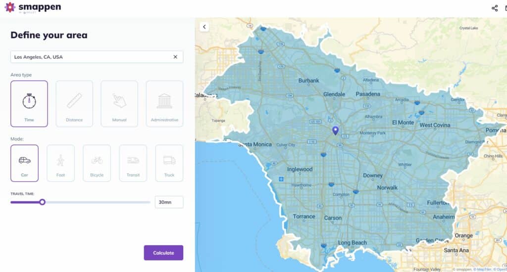
Depending on the mode of transport you pick, smappen looks at lots of criteria (speed limit on each type of road (city, countryside, highway, etc.), and draws the area that you can reach when travelling the specified distance or time.
These travel-time areas are also called isochrones or catchment areas.
Based on travel times
A driving-radius map tool.
Use smappen to get the right answers.

To choose the best location for your business
smappen provides you with population data on your areas, so that you know which is the best location for your business.
To optimize your logistics (delivery, pricing, technicians, etc.)
Save time and money by providing the best-optimized areas for your deliveries or technicians.
To go and visit friends
Just moved to a new city? Friends all over the country? Find where you can get to in a given travel time.
To target your marketing campaigns
Easily extract zip codes from your areas, for the best-targeted campaigns.
To find your next home or job
Want to move, but don’t want to be too far away from your place of work? smappen shows you the ideal geographic area where you should house-hunt, with a variety of home-to-workplace travel times.
Ready to get started with smappen?
The complete guide about travel time maps
Travel time is an essential element that shapes our daily lives, influencing decisions ranging from our commutes to work, to healthcare accessibility, leisure activities, and urban planning. The ability to understand, calculate, and visualize travel time is a game-changer in modern navigation and decision-making.
Behind the scenes of this crucial concept lies technology and data, working together to create what we call “travel time maps.” These maps are not just colorful representations but tools that empower us to make informed choices about where we go, how we get there, and how long it will take.
In this comprehensive guide, we will embark on a journey to explore the significance of travel time and travel time maps in our fast-paced world. We will delve into the technology that underpins their creation and see how data makes travel time mapping possible. Throughout this exploration, we’ll discover the practical applications of travel time maps and discuss strategies to optimize travel time for a more efficient and enjoyable life. So, let’s navigate the world of travel time and its mapping, enhancing the way we experience the world around us.
Understanding travel time
Travel time is more than just a measure of how long it takes to get from point A to point B. It’s a fundamental concept that profoundly affects our daily routines and decisions. In this section, we will unravel the core concept of travel time and its multifaceted impact on our lives.
At its heart, travel time encapsulates the minutes, hours, and sometimes even seconds that stand between us and our destinations. It governs our commutes to work, school runs, and even the time it takes to enjoy a day out with friends. Understanding travel time is the key to unlocking a more efficient and enjoyable life.
As we delve deeper, we will explore the multitude of factors that influence travel time. Weather, with its unpredictable whims, can either expedite or delay our journeys. Traffic congestion in urban jungles can turn a quick trip into a frustrating ordeal, while our choice of transportation mode can be the difference between a leisurely stroll and a hectic rush.
But what ties all these factors together into a coherent and user-friendly concept? The answer lies in the world of “travel time maps.” These visual representations take complex data on weather, traffic, and transportation modes, and present it in a way that’s easy to comprehend. In the next section, we will unravel the technology and data that make the creation of these maps possible.
Creating travel time maps
Travel time maps are the result of meticulous data integration and advanced GIS technology. These maps require access to a wide array of data sources, including real-time traffic information, location data, and comprehensive transportation networks. This data forms the foundation upon which travel time maps are built.
One of the pivotal elements in this process is GIS technology, such as the one offered by Smappen. Smappen, as an innovative geomarketing solution, plays a significant role in creating travel time maps. It leverages GIS technology to process vast datasets and produce visually intuitive maps that help individuals and businesses make informed decisions.
Creating a travel time map with Smappen can provide valuable insights for location-based decision-making. Below is a step-by-step tutorial on how to create a travel time map for free using Smappen:
- Go to smappen.com/app/
- Open the area creation panel on the top left
- Write your starting address
- Select the time
- Choose the means of transport
- Click on “Compute” button
Your first travel time area is created! For more detailed instructions, you can follow our tutorials .
Interpreting travel time maps
Understanding how to read and interpret a travel time map is vital in unlocking the wealth of information it offers to individuals, businesses, and decision-makers alike. These maps are designed to provide valuable insights into travel time, allowing for informed choices. Here, we’ll delve into the key aspects of interpreting travel time maps while incorporating relevant SEO keywords.
Color-Coding and Legends: A fundamental element of any travel time map is the color-coding scheme, where different areas are shaded in various colors to represent varying travel times. The intuitive use of colors serves as a visual guide, with darker hues typically signifying longer travel times and lighter shades indicating shorter journeys. Understanding these color patterns is crucial for quick and accurate interpretation of the map, especially when time is of the essence. Additionally, legends are often provided to clarify the specific time intervals associated with different colors, making it easier to gauge travel durations.
Real-World Examples and Decision-Making: The true power of travel time maps becomes evident when we witness them in action in real-world scenarios. These maps are not just abstract data representations; they play a practical role in guiding decisions. For instance, consider a business owner looking to determine the ideal location for a new store. By consulting a travel time map, they can pinpoint areas with shorter travel times to their target demographic, leading to better strategic choices. Similarly, urban planners utilize travel time maps to identify areas with limited transportation accessibility, paving the way for more efficient infrastructure development. These practical examples showcase the indispensable role travel time maps play in enhancing decision-making processes.
User-Friendly Digital Platforms: In the digital age, travel time maps have become more accessible and user-friendly than ever. Many platforms, such as Smappen, offer intuitive interfaces that make map interpretation a breeze. These digital tools allow users to zoom in, pan, and interact with the map, exploring different regions effortlessly. Whether you’re planning your daily commute or seeking the ideal location for a business expansion, the user-friendly nature of digital travel time maps streamlines the process. With a few clicks, you can gain valuable insights into travel times, empowering you to make more informed decisions in an ever-changing world.
By grasping the principles of color-coding, legends, and practical applications, you’ll be well-prepared to harness the potential of travel time maps in your daily life or business endeavors. Understanding how to interpret these maps effectively opens the door to better planning, improved decision-making, and optimized efficiency.
Applications and importance
Broad Applications Across Sectors: Travel time maps find relevance in a plethora of sectors, serving as a fundamental resource for informed decision-making. In the realm of transportation, they aid in optimizing routes and schedules for public transit systems, reducing commuter travel time and enhancing the overall transit experience. In healthcare, travel time maps guide medical facilities in identifying areas with limited accessibility, ensuring that critical services are within reach for all members of the community. Furthermore, urban planners employ travel time maps to develop efficient infrastructure and to design cities that are more accessible to all. These maps, enriched with data, play a pivotal role in enhancing the quality of life for residents and commuters alike.
Leveraging Travel Time Maps for Decision-Making: Businesses and individuals stand to gain significant advantages by leveraging travel time maps in their decision-making processes. For businesses, the strategic location of a store, warehouse, or distribution center can be a game-changer in terms of customer reach and operational efficiency. Travel time maps provide valuable insights into the ideal location for maximum accessibility. Individual commuters and travelers, too, can benefit from these maps by planning their daily journeys more efficiently, avoiding congestion, and optimizing their schedules.
Optimizing Efficiency and Accessibility: The value of travel time maps lies in their ability to optimize efficiency and accessibility in everyday life. For businesses, this means maximizing the reach of their services while minimizing operational costs. For individuals, it translates to reduced stress, more time for leisure and productivity, and a higher quality of life. With these maps in hand, individuals can make choices that take into account the time it takes to reach their destinations, ultimately improving the balance between their personal and professional lives.
Optimizing travel time with maps
Efficiently managing your travel time is not just about reaching your destination; it’s about transforming your daily journeys into smoother and more productive experiences. In this section, we will share practical strategies and tips for using travel time maps to your advantage, all while incorporating relevant SEO keywords for enhanced visibility.
Practical Strategies for Efficiency:
Plan Ahead: The cornerstone of optimizing your travel time begins with planning. Use travel time maps to foresee potential bottlenecks, traffic congestion, or delays in your route. By being proactive and considering these factors, you can plan your trips at times that minimize disruptions.
Combine Trips: If you have multiple errands or destinations, strategically combine them to minimize travel time. Travel time maps can help you identify areas where you can complete multiple tasks within a single journey, optimizing your schedule and reducing the overall time spent traveling.
Shows you areas you can reach with public transport in a given time.
See all the cities About
All Mapnificent Cities
Asheville, NC
Bolzano/Bozen
British Columbia
Buenos Aires
Christchurch
Colorado Springs
Fayetteville
Kansas City
Kuala Lumpur
Little Rock, AR
Los Angeles
Greater Manchester
Mexico City
Minneapolis
Netherlands
Orange County
Philadelphia
Raleigh/Durham
Rhein-Neckar
Salt Lake City
San Luis Obispo
Sonoma County
Switzerland
Toronto/Hamilton
Vitoria-Gasteiz
Washington D.C.
Westfalen-Lippe
Yamanashi Prefecture
Mapnificent shows you the area you can reach with public transport from any point in a given time. It is available for major cities in the US and world wide.
This is the new version of Mapnificent with many missing features! Find the source on GitHub and help out!
Want to add your city?
Follow this guide!
Mapnificent was originally inspired by mySociety's Mapumental .
Mapnificent was created by Stefan Wehrmeyer .
Follow @mapnificent on Twitter!
Create a Radius Map
Get the miles radius or km radius distance from any location, make a travel time radius map, see how far you can travel in a time limit by car, public transport, walking & more.
Start A Free Trial Now
No Credit Card Required
- Route Planning
How to Generate a Commute Time Map
- On Jan 11, 2021

Quickly determine the travel time between two locations or see how far you can commute in a certain time frame using a travel time calculator. Travel time calculators allow you to generate isochrones representing the area you can cover in a certain period of time using public transit, bike, walking, or driving. Travel time and commute time maps are useful for a wide range of use cases from personal use like choosing a house location that is no more than 20 minutes from your work to business use cases like choosing a new office location close to all of your employees as possible.
Table of Contents
What is a Commute Time Map?
A commute time map, or travel time map, allows you to see the time it will take you to commute between a starting point and the locations that you can reach in a certain period of time from that starting point. Instead of measuring distance, a travel time map measures commute time.
Calculating commute time depends on several factors, including distance, traffic conditions, transport mode, and transit information. Commute maps factor all this in to give you accurate estimates of your travel time. This means estimates are calculated in real-time and might fluctuate from one time of day to another.
Use a commute time calculator to determine the average commute time from one location to another or draw a travel time radius around one location to see all the other reachable locations within a given time limit.
These calculations are available for driving and various forms of public transport, such as buses and trains.

What Can You Do with a Commute Time Map?
Many companies use travel time maps to optimize their business and better serve their customers:
- Site Selection Based on Customers: Choose business locations based on commute times from specific neighborhoods, zip codes, suburbs, and metropolitan areas to ensure your customers can easily reach you.
- Site Selection Based on Employees: Select work locations near your employees to help them avoid long commutes.
- Assign Sales Reps: Choose sales reps to work with customers based on commute time to optimize your customer service.
- Real Estate: List the various businesses, services, and amenities that are reachable from a property within a specific commute time.
How to Create a Commute Time Map with Maptive
Step 1: Sign up for a Maptive free trial account . Try Maptive for free and explore the many mapping tools we have to offer.

Step 2: Upload or input your data. Upload your location data from an existing Excel spreadsheet, copy and paste your data into Maptive, or enter it manually.

Step 3: Click on “Map Now” to view your map. Your location data is now plotted on a beautiful interactive map.
Step 4: Choose the Distance Radius/Drivetime Polygon Tool . Select this feature from Maptive’s tools menu.

Step 5: Select “Drive Time Polygon” from the dropdown menu. Enter your trip details. This includes your start location & travel time in hours or minutes.

Step 6: Get your commute time. Your commute time map will be automatically calculated based on your trip details.

Fred Metterhausen is a Chicago based computer programmer, and product owner of the current version of Maptive. He has over 15 years of experience developing mapping applications as a freelance developer, including 12 with Maptive. He has seen how thousands of companies have used mapping to optimize various aspects of their workflow.
Learn More About Our Features
Find out why Maptive is the most powerful mapping tool on the market.
Read Testimonials
See what Maptive users have to say about our software.
Start Your Free, No Risk, 10 Day Trial
No credit card required. No surprises. Just Results.
Related Articles

- Data Science
Complete Guide to Conducting Healthcare Market Research

- Entrepreneurs
How to Get More HVAC Leads: 10 Effective Strategies

The Best GIS Certificate Programs in 2024
Privacy overview.
Welcome to 511 PA
Get started to discover new and exciting features!
Signing up with 511PA
- Creating an account is NOT mandatory on this website; however if you do, you’ll be able to personalize your experience and receive traffic alerts.
- Select ‘Sign Up’ from the menu options in the top right corner
- Enter your name, email, and create a password. Click ‘Sign Up' when done.
- You will get an email to verify your account, click the link that was sent to your email.
- Including a phone number will allow you to receive text alerts, you will receive an SMS (text) with your confirmation code. Note this is in addition to the email verification.
Creating & Saving a Customized Route
- Review the routes generated and select the one that suits you best.
- When done, enter a name for your route and click ‘Save’.
Creating an Alert for your Route
- Once your route is saved, you will be asked if you want to be notified of events on this route. Click ‘Create Route Notification’
- You will be redirected to the alert creation page. Enter the required information for your route, select a delivery option (email or SMS), and click ‘Save’.
- You will now be notified of any future events that affect your route.
Welcome to 511PA
- Verify your account by following the link that was sent to your email.
- If you registered with a phone number, you will also receive an SMS (text) with your confirmation code
- In the Manage My Routes table, find the route that you previously saved that you would like to create an alert for and click ‘Create Alert’.
Content for Heading
There's no additional information right now.
My Cameras Toggle
To add to My Cameras View:
- Map page - Click on a camera icon on the map, then click the "My Cameras" button at the top of the camera popup. Select from the Camera View list to add or de-select to remove.
- Camera page - Click on the three dots icon below the camera image to access the "My Cameras" option. Select from the Camera View list to add or de-select to remove.
- Closed/Stopped
- Speed Restrictions
- Vehicle Restrictions
- Limited Services
- Out Of Service
Would you like to be notified of events on this route?
Default options for receiving Event Notifications:
- 6 AM - 6 PM

Quick Links
Who uses travelmath.
Companies like United Airlines, Southwest Airlines, and Ryanair use Travelmath to re-route passengers and plan new flight paths.
Celebrities love Travelmath!
"Travelmath is the one app I couldn't live without - it calculates all your journey timings and because I travel a lot, it's essential. Whoever invented Travelmath, I love you! " – Drew Barrymore
"There's a website called Travelmath, it's really good if you're into flight times. " – Blake Griffin
Dirtiest Public Transit
See the research from our Travelmath study on public transportation hygiene. How does the New York subway rank against Chicago, DC, SF, and Boston? Read the full study!
Germiest Hotel Rooms
See even more research from our Travelmath study on hotel hygiene. Spoiler alert: Don't turn on the TV... Read the full study!
Travel Tools
What is travelmath.
Travelmath is an online trip calculator that helps you find answers quickly. If you're planning a trip, you can measure things like travel distance and travel time . To keep your budget under control, use the travel cost tools.
You can also browse information on flights including the distance and flight time. Or use the section on driving to compare the distance by car, or the length of your road trip.
Type in any location to search for your exact destination .
Quick Calculator
How do i search.
To get started, enter your starting point and destination into the boxes above. If you want an airport , it's best to enter the 3-letter IATA code if you know it. For cities , include the state or country if possible.
You can also enter more general locations like a state or province , country, island , zip code, or even some landmarks by name.
Check Prices
Home · About · Terms · Privacy
My itinerary
This is a free demo version of our mapping software.
Create an account to save your current itinerary and get access to all our features.
Otherwise your data will be automatically deleted after one week.
- CO2 Emission

Travel Time Calculator
Faq about travel time.
© 2011-2024 distancesfrom.com. A softUsvista Inc. venture!
What is TravelTime?
Travel Time Map Generator & Isochrones
I know i can get from a to b by public transport within my selected time, but it's not showing up.
If you're using public transport to do your analysis, it can look like we don't include a specific transit line. But it is rare that we have forgotten to add it! We have a full data team collecting transport data, and they're rarely caught out. It's usually due to understanding how we calculate travel time catchments. We build the area to include:
- Walking to the station platform
- Waiting for the next available departure
- Time spent boarding the train
- Giving enough time to take the A to B journey
- Depart on the station on the other side.
That means if you set your max travel time at 30 minutes, and the train journey you think should be included takes 28 minutes, it probably won't show up, because the other steps push it over the max 30 min limit. Try adding an extra 5-10 minutes to your max catchment area and see if this helps! Understand how we built our public transport model
You can't drive that far / you can drive much further than that
We recommend that you do a little experiment.
- Open another mapping app of your choice and enter an A to B route
- Select a departure time for tomorrow.
The average mapping provider gives very vague driving estimations. It's not uncommon to see a journey estimation between 30 minutes up to 2 hours. That's a lot of buffer room!
Our driving model only returns one singular best possible time estimate. We do this using our purpose-built driving model. Explore how we've built our driving model.
Still not convinced?
You can explain your data issue to us here and we can help you out. Please include in your request whether you're using the API for commercial or personal purposes.
About this tool
This demo was built to showcase the TravelTime API. To use the full capabilities of the API you will need coding skills, or experience with one of our integrations: QGIS, Alteryx or ArcGIS. Access to the API gives you larger travel time catchment areas, more transport mode options and large request volumes. Access the developer playground here.
What is a travel time map?
Our map tool allows you to create a 'How far can I go map' by transport mode and time limit. For example someone can ask how far can I drive from my home in 30 minutes. The tool outputs shapes, also known as travel time isochrones visualise where's reachable. Sometimes these shapes are incorrectly labelled as a 'travel time radius map'. A radius is always just a circular shape, but a travel time shape is completely unique as it analyses all locations reachable using a specific mode of transport.
How to create a drive time radius map or other modes
- Select a start location
- Select a maximum travel time limit
- Select a mode of transport, for example driving
- Voila! There's your driving radius map
Use cases for consumers
- Create a commute time map so you can see where to live based on commute time.
- How far can i travel in a given time: compare transport coverage for different areas.
- Create a drive time radius map: explore how far you can travel on a road trip.
Use cases for businesses
- Travel time mapping up to 4 hours & cross reference other data sets in GIS such as population data
- Site selection analysis: analyse the best location to locate a business by adding thousands of analysis points
- Create a distance matrix or travel time matrix & calculate travel times from thousands of origins to thousands of destinations
- Network analysis / travelling salesman problem: use spatial analytics to solve routing problems
- Commute time map - plot thousands of employee commute times for an office relocation
This web page is a limited demo that can do the following:
- Create up to 3 time polygons visualising where's reachable within 2 hours or less. Our API can create large travel time areas, talk to sales.
- Calculate travel times from an origin to various points of interest - in this demo we use points from Foursquare Give A to B routing details
Full access
We provide full analysis by all transport modes and all travel time areas in our full service. You can access this by:
- Book a demo
- Trial TravelTime API
- Trial QGIS Plugin
- Trial ArcGIS Pro Add-In
- Trial Alteryx Macros
Problem with the data?
- Nation & World
Father-son duo finishes quest to visit every presidential grave in U.S.
TJ Fallon started visiting U.S. presidential grave sites during the height of the COVID-19 pandemic in 2020.
“I did it out of complete boredom after being furloughed from my job,” the New Jersey native said.
Four years later, not only has he visited all 39 presidential grave sites at least twice, but — as of this month — his son, Henry, 10, has also seen them all.
Henry, of Brick, New Jersey, likely has become the youngest person ever to check off the feat of paying homage to every dead president after he and his father disembarked from their inbound flight to LAX to visit the Ronald Reagan and Richard Nixon libraries.
“I’m nervous and excited,” Henry said before walking to Nixon’s grave site in Yorba Linda, California, the visit that would cap his achievement.
Afterward, he said he “kind of” felt accomplished to have seen every presidential grave.
Travel headlines and tips
- WA destination makes list of 10 ‘second cities’ to visit this fall
- Climate change drives rise in ‘last-chance tourism,’ which can be risky
- These 6 European spots hit their breaking point this summer
- Hawaii considers new ferry service linking three islands
- New Zealand triples entry levy it charges foreign visitors
- Is loyalty dead? When to stay put, when to bail | Travel Troubleshooter
- Expert tips for getting decent sleep on a red-eye flight
- Late-summer travel plans? You might want to wear a mask
The Fallons have traveled across the country to visit presidential libraries and cemeteries. They spent Henry’s spring break, for instance, road-tripping around Kansas and Missouri to see the graves of Eisenhower and Truman.
Henry’s favorite president? Lincoln.
But, like many 10-year-olds, Henry is not a big history buff and seems practically uninterested in politics. He zipped through the Nixon Library in an Aaron Judge baseball cap, spending more time practicing his batting swing than paying attention to the exhibits.
His favorite museum is the National Baseball Hall of Fame in Cooperstown, New York, he said. And his favorite part of these road trips with Dad is not visiting the presidential gravesites, but stopping at the ballparks along — and sometimes out of — the way. The Fallons were also headed to Dodger Stadium and San Francisco’s Oracle Park — as well as Dinseyland — this week.
“People always ask me why I visit presidential grave sites,” TJ Fallon said. “It’s an odd hobby. But it humanizes all these great figures. They were people with families. They were mortal.”
The hobby began with a random Google search in 2020 when Fallon asked if any presidents are buried in New Jersey. In fact, Grover Cleveland is buried in Princeton. Though Cleveland never attended college, he fell in love with the area after delivering an address at the university in 1896, made Princeton his home after his second term as president and became a trustee of the Ivy League school.
After visiting Cleveland’s grave site, Fallon made an ambitious Google search. “Has anyone visited every presidential grave site?”
Based on his research, Fallon said it seemed like at least one person had done so and maybe others. He set out to do it faster.
View this post on Instagram A post shared by Dead History (@deadhistory1776)
So, he drove more than 60,000 miles through 34 states to visit all of them in nine months. He’s also gone to all 34 graves of vice presidents, 53 of the 56 graves of the signers of the Declaration of Independence, and all 39 signers of the Constitution. He’s been featured by his hometown paper and Jay Leno’s show “You Bet Your Life;” he has 20,000 subscribers on his “Dead History” YouTube channel and 50,000 followers on Instagram.
Fallon says Nixon has the best epitaph of any president: “The greatest honor history can bestow is the title of peacemaker.” Meanwhile, he believes Martin Van Buren might have the most unassuming grave site in a small cemetery in his hometown of Kinderhook, New York.
Fallon’s enthrallment with presidential history might not have totally rubbed off on Henry, but at least they’ll always have this journey together to look back on.
Seeing America with his dad, Henry said, “means a lot.”
Most Read Nation & World Stories
- A 14-year-old student fatally shot 4 people in a rampage at a Georgia high school, officials say VIEW
- Disney-obsessed couple loses lawsuit to get back into exclusive Club 33
- Inmate awaiting execution says South Carolina didn't share enough about lethal injection drug
- Something’s poisoning America’s farms. Scientists fear ‘forever’ chemicals VIEW
- GOP nominee for Senate in Montana was recorded using racist stereotypes about Native Americans
Security Alert May 17, 2024
Worldwide caution.
- Travel Advisories |
- Contact Us |
- MyTravelGov |
Find U.S. Embassies & Consulates
Travel.state.gov, congressional liaison, special issuance agency, u.s. passports, international travel, intercountry adoption, international parental child abduction, records and authentications, popular links, travel advisories, mytravelgov, stay connected, legal resources, legal information, info for u.s. law enforcement, replace or certify documents.
Share this page:
Kiribati Travel Advisory
Travel advisory august 9, 2023, kiribati - level 1: exercise normal precautions.
Reissued with updates to health information and Travel Advisory Level.
Exercise normal precautions in Kiribati.
Read the country information page for additional information on travel to Kiribati.
Commercial transportation to/from Kiribati is sporadically available.
If you decide to travel to Kiribati:
- Monitor local media.
- Bring a sufficient supply of over-the-counter and prescription medicines.
- Enroll in the Smart Traveler Enrollment Program ( STEP ) to receive security messages and make it easier to locate you in an emergency.
- Follow the Department of State on Facebook and Twitter .
- Review the Country Security Report for Kiribati.
- Visit the CDC page for the latest Travel Health Information related to your travel.
- Prepare a contingency plan for emergency situations. Review the Traveler’s Checklist .
Travel Advisory Levels
Assistance for u.s. citizens, kiribati map, search for travel advisories, external link.
You are about to leave travel.state.gov for an external website that is not maintained by the U.S. Department of State.
Links to external websites are provided as a convenience and should not be construed as an endorsement by the U.S. Department of State of the views or products contained therein. If you wish to remain on travel.state.gov, click the "cancel" message.
You are about to visit:

About Sarajevo
The city of Sarajevo is divided into four municipalities; however, it is Stari Grad (the Old Town) that is undoubtedly the city’s crown jewel. The eastern section of Stari Grad is home to the 15th-century Ottoman quarters. Wandering among the atmospheric alleyways of the Bascarsija, you will be transported to another time and place by the sight of its splendid architecture, the sound of the muezzin from the Gazi Husrey-Beg Mosque and the smell of freshly cooked cevapcici filling the air.

More Articles
Travel like an expert with aaa and trip canvas, get ideas from the pros.
As one of the largest travel agencies in North America, we have a wealth of recommendations to share! Browse our articles and videos for inspiration, or dive right in with preplanned AAA Road Trips, cruises and vacation tours.
Build and Research Your Options
Save and organize every aspect of your trip including cruises, hotels, activities, transportation and more. Book hotels confidently using our AAA Diamond Designations and verified reviews.
Book Everything in One Place
From cruises to day tours, buy all parts of your vacation in one transaction, or work with our nationwide network of AAA Travel Agents to secure the trip of your dreams!
Planned outage: Files stored in our eDOCS platform may be temporarily unavailable today from noon to 1 p.m.
Skip to Content
511 Travel Info
News releases
Sept. 4, 2024
Latest news releases
Preliminary work for the 2025-26 Hwy 22 Mankato to St. Peter project is underway on Industrial Street near Kasota
Hwy 22 from mankato to st. peter will remain open to traffic in 2024.
MANKATO, Minn. — Preliminary work for the 2025-26 Hwy 22 Mankato to St. Peter construction project is underway on Industrial Street near Kasota, according to the Minnesota Department of Transportation.

Construction on Industrial Street between Le Sueur Co. Rd. 41 (Pearl Street) and Le Sueur Co. Rd. 21 includes the installation of erosion control devices, tree and vegetation removal, and pavement work. Starting next week, crews will begin construction of a new roadway adjacent to Pearl Street to expand Industrial Street and provide business access during Hwy 22 construction in 2025-26. Work also includes the realignment of the existing Industrial Street, installation of drainage structures and culverts, curb and gutter, pavement, and lighting.
Local access for businesses near Industrial Road will be maintained with minor impacts for motorists. This work is anticipated to be complete in mid-October, weather permitting. (map attached)
Hwy 22 from Mankato to St. Peter will remain open to traffic in 2024; however, motorists can expect minor traffic impacts for utility and other preliminary construction work.
All construction activities and traffic impacts are weather dependent and subject to change. MnDOT urges motorists to be attentive and drive with caution in work zones where workers are present.
Le Sueur Co. Rd. 45 (Rabbit Road)
Originally planned for construction in 2024, construction on the Le Sueur County 45 (Rabbit Road) bridge has been postponed until 2026. The work on Rabbit Road in 2026 will include a mill and overlay, replacement of the approach panels, new drainage and culverts, and new guardrail.
Hwy 22 Mankato to St. Peter project overview, costs
Hwy 22 from Mankato to St. Peter will be closed in 2025-26, with traffic detoured. The project will include reconstructing the roadway from south of Blue Earth County Road 57 in Mankato to just south of the Minnesota River Bridge in St. Peter, and adding new turn and passing lanes. The project also includes constructing a roundabout at Hill Street (Le Sueur Co.Rd. 21) in Kasota, improving lighting at intersections, repairing and replacing bridges, installing snow fence, and preparing for future construction of a walking and biking trail to connect Mankato to St. Peter.
Benefits of the project include enhanced safety for motorists, improved traffic flow, smoother pavement, and preparation for a future walking and biking trail. Mathiowetz Construction Company was awarded the project with a bid of $36,896,294.56.
Hwy 22 and Augusta Drive roundabout project in Mankato
Construction of a dual-lane roundabout at the intersection of Hwy 22 and Augusta Drive in Mankato is expected to continue until early October. The project also includes constructing new trail and realigning existing trails. Visit the Hwy 22/Augusta Drive project website for more information and detour routes. l
Stay connected
- Visit the Hwy 22 Mankato to St. Peter project website for more information and sign up for email updates.
IMAGES
VIDEO
COMMENTS
TravelTime Features. See 'How far can I get' in X minutes. Create a drive time map or any other transport mode. Overlap many shapes & highlight overlap area. Search points of interest within the area. Get A to B routing details. Create a travel time map in a few clicks. Select your maximum walking, cycling, public transport or drive time radius ...
Provide up to 26 locations and Route Planner will optimize, based on your preferences, to save you time and gas money. Find the shortest routes between multiple stops and get times and distances for your work or a road trip. Easily enter stops on a map or by uploading a file. Save gas and time on your next trip.
Intro: Build reachability maps. Check how far can you go from your working or study place, to find a place to live reachable within the desired commute time. Enter an address in the location input or just click on the location on the map. Check the reachability area on the map. You can change the travel mode and travel time to build a new ...
36.668 | -78.387. Got it. Realtime driving directions based on live traffic updates from Waze - Get the best route to your destination from fellow drivers.
Travelmath helps you find the driving time based on actual directions for your road trip. You can find out how long it will take to drive between any two cities, airports, states, countries, or zip codes. This can also help you plan the best route to travel to your destination. Compare the results with the flight time calculator to see how much ...
Official MapQuest website, find driving directions, maps, live traffic updates and road conditions. Find nearby businesses, restaurants and hotels. Explore!
Did you know: If you use the Roadtrippers mobile app, your trips will instantly auto-sync over... Ready for navigation and good times! Search. The ultimate road trip planner to help you discover extraordinary places, book hotels, and share itineraries all from the map.
Customizable travel time search means you display the results that matter to your customers, which establishes your business as one they can rely on. 20 min. With Geoapify isochrone maps, you can refine the route by your preferred mode of transport. Choose from walking, driving, truck, bicycle, or public transit.
Find local businesses, view maps and get driving directions in Google Maps.
Directions. Get step-by-step walking or driving directions to your destination. Avoid traffic with optimized routes. Step by step directions for your drive or walk. Easily add multiple stops, see live traffic and road conditions. Find nearby businesses, restaurants and hotels. Explore!
Leveraging Travel Time Maps for Decision-Making: Businesses and individuals stand to gain significant advantages by leveraging travel time maps in their decision-making processes. For businesses, the strategic location of a store, warehouse, or distribution center can be a game-changer in terms of customer reach and operational efficiency. ...
Mapnificent shows you the area you can reach with public transport from any point in a given time. It is available for major cities in the US and world wide. This is the new version of Mapnificent with many missing features!
Let's take a look at the top five apps that calculate travel time. 1. Waze. Waze is a real-time community-based traffic and navigation app for driving. 2. Citymapper. Citymapper is a transport app that allows users to search for driving, cycling, walking and public transport routes in urban areas.
Click "Create Map" to instantly plot your data on an interactive map. Click the Tools icon in the top right corner of your screen. To find the distance between two locations, select the "Routing / Directions" tool. Enter your starting location and your destination to see the travel time. You can also add additional stops and determine ...
Create a 'X' minute radius map in seconds with this quick tool that draws circles around a point. Compare miles radius & kms radius to drive time areas & more.
Step 4: Choose the Distance Radius/Drivetime Polygon Tool. Select this feature from Maptive's tools menu. Step 5: Select "Drive Time Polygon" from the dropdown menu. Enter your trip details. This includes your start location & travel time in hours or minutes. Step 6: Get your commute time.
Plan your route with the AA Route Planner, including directions, traffic updates, and maps for a smooth journey.
Provides up to the minute traffic and transit information for Pennsylvania. View the real time traffic map with travel times, traffic accident details, traffic cameras and other road conditions. Plan your trip and get the fastest route taking into account current traffic conditions.
What is Travelmath? Travelmath is an online trip calculator that helps you find answers quickly. If you're planning a trip, you can measure things like travel distance and travel time.To keep your budget under control, use the travel cost tools. You can also browse information on flights including the distance and flight time. Or use the section on driving to compare the distance by car, or ...
How Travel Time Map works? - Login or register. - Create a map selecting the starting point and limit area. - Travelling mode: by auto, feet or *bike. (*) Only available in some parts USA. - Select the number of points of the mesh. See prices. They effect on the quality and accuracy of the map. - Payment with Paypal or Wire transfer.
Add your travel destinations on a map, select your transport modes, visualize and share your itinerary for free. My itinerary This is a free demo version of our mapping software. Create an account to save your current itinerary and get access to all our features. ...
Get scale and accuracy with TravelTime. Calculate millions of unique, accurate travel times in an instant without the big price tag. Enrich applications with scalable accurate proximity data - great for last-mile delivery, vertical search engines, supply chain logistics, hiring temporary staff and more. Discover how proximity will transform ...
Estimate time required to travel between two addresses. Calculates the total time for a round trip or a multi-city trip between cities or locations. Direction Map Travel Time LatLong Flight D Flight T HowFar Route TripCost. CO2 Emission. Calories. Planner; Trip Cost; Itinerary. Percentage share.
A radius is always just a circular shape, but a travel time shape is completely unique as it analyses all locations reachable using a specific mode of transport. How to create a drive time radius map or other modes. Select a start location. Select a maximum travel time limit. Select a mode of transport, for example driving.
Updated with additional water safety information. Exercise increased caution in The Bahamas due to crime.. Country Summary: The majority of crime occurs on New Providence (Nassau) and Grand Bahama (Freeport) islands.In Nassau, practice increased vigilance in the "Over the Hill" area (south of Shirley Street) where gang-on-gang violence has resulted in a high homicide rate primarily ...
Zillow has 14 photos of this $82,000 4 beds, 2 baths, 1,512 Square Feet manufactured home located at 0 Real Ln, Palmer, AK 99645 built in 1994. MLS #24-11284.
Travel headlines and tips. WA destination makes list of 10 'second cities' to visit this fall; These 6 European spots hit their breaking point this summer
Reissued with updates to health information and Travel Advisory Level. Exercise normal precautions in Kiribati. Read the country information page for additional information on travel to Kiribati. Commercial transportation to/from Kiribati is sporadically available. If you decide to travel to Kiribati: Monitor local media.
NATIONAL PARK Cape Breton Highlands National Park Cape Breton Highlands National Park has entrances on the Cabot Trail 5 kilometres (3 mi.) northeast of Chéticamp on the west side of the island and at Ingonish Beach on the east. The park is in the northern part of Cape Breton Island. Bounded on the west by the Gulf of St. Lawrence and on the east by the Atlantic Ocean, the park protects ...
511 Travel Info. General Contacts; MnDOT A to Z; Search; News releases. Sept. 4, 2024 ... This work is anticipated to be complete in mid-October, weather permitting. (map attached) Hwy 22 from Mankato to St. Peter will remain open to traffic in 2024; however, motorists can expect minor traffic impacts for utility and other preliminary ...