Discover Which Colorado Mountain Town is right for you

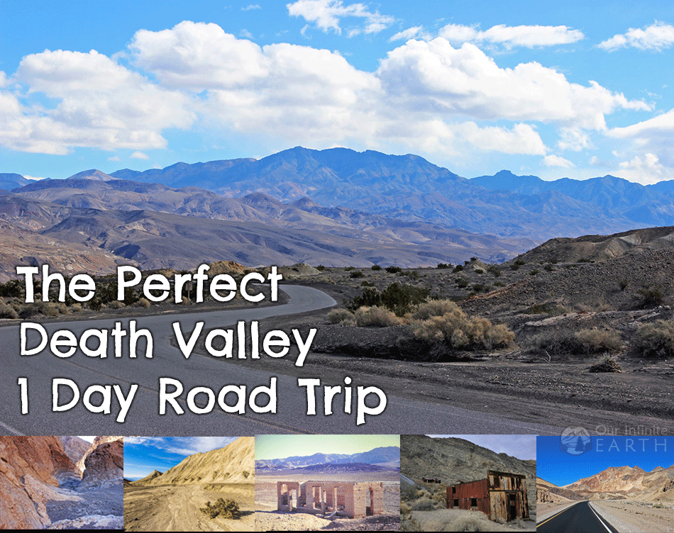
Your Utterly Scenic Death Valley Itinerary
- December 3, 2020
- By foxintheforest
Last Updated on January 15, 2024 by foxintheforest
As the largest national park in the Lower 48, Death Valley has a lot to offer. Eerie rock formations and ever-expanding salt flats feel other-worldly. Make the most of your visit with this Death Valley itinerary designed to bring you the most beautiful scenes in Death Valley.
Taking a Death Valley Road Trip – long or short – is definitely a beautiful experience. Don’t let the name fool you – this place has plenty of life. In fact, it’s real name is “Tumpisa” or “land of the red paint rock.”
I’ve been all over the country, and Death Valley truly surprised me. It’s vast, dramatic landscape brings a beauty that’s hard to describe. Even photos don’t really do the place justice.
About this Mega-Epic Death Valley Itinerary
Okay, so as a full-time outdoor writer, I’ve become an expert at making the most of your time outdoors. This stunning Death Valley itinerary features:
- Info on when to visit Death Valley National Park
- How many days to spend exploring the park
- Accessing the park and how to plan a Death Valley road trip
- A comprehensive Death Valley itinerary featuring one day in Death Valley and additional days.
- Camping and places to stay
- Tips for visiting Death Valley
- Additional planning resources
When to Visit Death Valley
One of the great things about Death Valley is the ability to visit the park year-round and still be able to see (most) main attractions.
Remember, Furnace Creek – inside the park – is the HOTTEST place in the country. I’m talking melt-your-skin-off 130-degree temps. SCORCHER.
Therefore it’s best to visit Death Valley between October and April. Fall sees less crowds. Winter is best for camping and hiking. While spring is busy with wildflower viewers.
Summer is possible, but come prepared! Lots of sunscreen, long-sleeve UPF clothing, plenty of water and electrolytes, and a robust vehicle with aircon.
How Many Days Should I Spend in Death Valley?
There are several unique ways to go on a Death Valley road trip, however most Death Valley itineraries are a maximum of 3 days.
If you only have one day in Death Valley, you can easily see many of the big highlights.
Since some of the other must-see attractions are so spread out, two days is a perfect amount of time to spend in Death Valley.
For those that don’t want to feel rushed – or have a particular interest in mining history – three days is perfect.
Pro Tip : It’s $30 to enter Death Valley National Park or free with an America the Beautiful Parks Pass.
Going on a Death Valley Road Trip
Alright, so if you’ve looked on a map, you’ll see that Death Valley is kind of…out there. In fact, it feels like the middle of nowhere. This certainly adds to the mistique of the park.
There are two main ways to go on a Death Valley road trip. Head from the east or west side of the park.
From Las Vegas
Death Valley is one of the best day trips from Las Vegas. If you’re arriving from Las Vegas, the easiest way to access Death Valley is to head east on US 95, then head south State Road 160.
You’ll pass through Pahrump, a small town that’s perfect for mid-priced lodging (and cheap gas). Fill up on gas here before heading out on your Death Valley itinerary.
From Los Angeles
The fastest way to get to Death Valley from LA is to head past Barstow on I-15 and swing northeast around the park. You’ll pass Death Valley Junction – an odd ghost town.
Alternatively, you can access the park from the west side via Panamint Springs. This is your best option if you want to create a Death Valley road trip that includes stops like Alabama Hills, the Sequoia National Forest and other awesome places in California.
Death Valley Itinerary Day 1
First, stop at one of the pay stations near Furnace Creek (or others). It’s $30 for 7 days in the park. Other fee stations include:
- Stovepipe Wells Ranger Station
- Grapevine Ranger Station
- Zabriskie Point
- Hell’s Gate
- Campgrounds in the park

See the Drama of Death Valley at Dante’s View
Your first stop takes you to 5,476 feet above sea level. Dante’s View is hands-down one of the best things to see in Death Valley.
This mega-stunning viewpoint shows you just how vast (and tall) Death Valley really is. The elevation difference between the highest point – Telescope Peak – and the lowest point – Badwater Basin – is over 11,000 feet.
If you can make it here for sunset, ah-mazing! If not, the views are still stellar all day.
Pro tip: Bring a jacket, it’s actually chilly up here!
Distance from Furnace Creek: 24 miles, 40 minutes
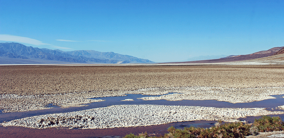
Scope Out the Sand Flats at Badwater Basin
After you’ve soaked up the most of the panorama at Dante’s View, you’re going down. Way down.
Badwater Basin is the lowest point in the US at -282 feet below the sea. The salt leeches from below the ground and creates stunning crystal formations. With the salt comes the moisture. The ground is surprisingly wet just below the salt crust. There are even lakes here.
Take your time and explore, but be aware of the heat. This stop is best at the beginning of the day before the crowds show up and the sun becomes too oppressive.
There are toilets here too, so take advantage if you need the facilities.
Pro tip: This place sucks the life out of you quickly. Salt pans dry out your skin and reflect the sun’s rays. Bring sunscreen, wear proper footwear, and don’t wander too far if it’s hot.
Distance from Dante’s View: 41 miles, 1 hour.

Hike the Natural Bridge
This short trail is only 2 miles round-trip and is an easy hike if the temperatures are cooler.
You’ll spot a stunning natural bridge and see just how uniquely strange the rock is here. It’s almost as if it will crumble at any moment, but at the same time, the clay-like soil is very unforgiving.
If you’ve seen the best of the American Southwest, this is a ho-hum hike (scope out Golden Canyon instead). However, if you’ve never seen a natural bridge before, it certainly has a wow-factor!
Pro Tip: If you’re visiting during the warmer months (April through October) hike the Natural Bridge after Dante’s View. Then head to the Devil’s Golf course for a delicious lunch. Afterwards, peep Badwater basin before continuing with the rest of this Death Valley itinerary.
Distance from Badwater Basin: 5 miles, 10 minutes
Pack a Picnic Lunch at the Devil’s Golf Course
For a whacky and weird lunch spot, take the dirt road to the Devil’s Golf Course. Signs on Badwater Road guide the way (you’ll pass it if you’re coming from Dante’s View to Badwater).
Here you’ll be able to see just how much upheavel and movement the floods, salt, and water cause. Sometimes salt formations form that look like golf balls (or eggs) which is where the spot got it’s name.
Plan for a picnic lunch in your vehicle (if it’s hot) or pop the trunk and sit facing this strange landscape. Don’t forget to pack out all of your trash.
Pro tip: The terrain here is unforgiving. It’s easy to trip and fall so take care.
Distance from Natural Bridge Trailhead: 12 miles, 17 minutes
Drive to the Painted Hills of Artist’s Pallet
One of the highlights of one day in Death Valley has to be Artist’s Drive. These gorgeous hills appear to be brushed by an artist with their vibrant greens, purples, and yellows.
The colors come from various minerals and elements in the rock. Half way through the drive you’ll reach Artist’s Pallet. This pull out gets you up close and personal to these stunning hillsides.
You can walk around and explore a little to really admire the view. Also, this is a great spot for a toilet break.
The one-way loop drive through these stunning hills is a must-do on any Death Valley itinerary. Honestly, I thought it was a highlight of the park. Take your time and use the little dirt pullouts to explore this area further (and without crowds).
Pro Tip: The colors are at their brightest when the sun is at its highest. Visit during the middle of the day for the best color.
Distance from Devil’s Golf Course: 10 miles, 20 minutes

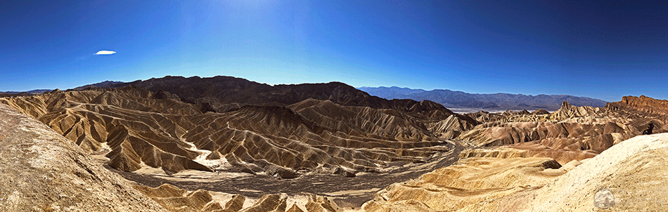
Catch a Sunset at Zabriskie Point
By this point, you may be tuckered out (or the sun may be heading to bed). If you’ve got time, check out the “More Options” section for nearby attractions to add to your Death Valley itinerary.
If not, then round out your day with a sunset at Zabriskie Point. Watch as the sun lowers over the horizon and the golden hills come to life with playful shadows. This easy overlook has benches and a few nearby hills to explore.
Distance from Artist’s Drive: 13 miles, 22 minutes
If you’re only spending one day in Death Valley then now is the time to head back. Or, you can opt to stay until the sky grows dark and check out the stars!

Stargazing in Death Valley
Death Valley National Park lies in one of the few Dark Sky Territories left in the US. This means that there is no light polution to obstruct your nightime view.
One of the most amazing parts of any multi-day Death Valley itinerary is stargazing. A few of the most incredible spots to see the stars is:
- Dante’s View
- Harmony Borax Works
- Badwater Basin
- Mesquite Flat Sand Dunes
More Options for One Day in Death Valley
If you’re quick to see the sights, you can scope out these additional nearby attractions in this section of Death Valley National Park:
- Twenty Mule Team Canyon : Short scenic drive with short hiking opportunities. Near Zabriskie Point.
- Golden Canyon: 4.4-mile scenic loop hike (Gower Gulch) great for sunset. Near Artist’s Drive. Could do instead of Natural Bridge.
- Furnace Creek Visitor Center: Learn about the unique history and geology of this magical location. Closed in 2020.
Where to Stay in Death Valley
There are not too many options when it comes to where to stay in Death Valley. In fact, there are only a couple of (expensive) lodging options inside the park.
- Stovepipe Wells Hotel
- The Inn at Furnace Creek
- The Ranch at Furnace Creek
- Panamint Springs Resort
For lodging outside the park, check out the towns of Beatty, Nevada in the north or Pahrump towards the south end of the park. Both towns offer mid-range lodging that’s cheaper than staying inside Death Valley.
Death Valley Camping
If you’re keen to camp in the desert, then reserve a spot (or use a first-come-first-served campground) inside Death Valley National Park. Camping is closed during the summer months. You’ll find 9 campgrounds in the park:
- Furnace Creek: Reservations. Open year-round (summer not recommended).
- Sunset at Furnace Creek : first-come-first-served
- Texas Spring at Furnace Creek : first-come-first-served
- Stovepipe Wells : first-come-first-served
- Mesquite Spring : first-come-first-served
- Emigrant: first-come-first-served. Tent only.
- Wildrose : first-come-first-served
- Thorndike : first-come-first-served. 4WD required.
- Mahogany Flat : first-come-first-served. 4WD required.
Death Valley Road Trip Day 2
Risse and shine! It’s time for day 2 of this Death Valley itinerary. Today you’ll be exploring the northern end of the park. With plenty of beautiful sites and mining history, there’s a lot to see.
Wonder About the Stones at the Racetrack Playa
Start your day early and head toward one of Death Valley’s more remote attractions, Racetrack Playa. It’s a bumpy ride, but worth it to check out this unique place.
The first thing you’ll notice are the rocks that seem to 1) come from nowhere and 2) move. Yup. That’s right. These rocks travel (you can tell from the depression of mud behind them).
Scientists are still stumped by this phenomena. Please don’t move the rocks, or step on their unique trails across the badlands.
Pro Tip: This place is far out of the way. You’ll need a 4×4 vehicle to make this bumpy journey.
Distance from Furnace Creek: 83 miles, 3 hours

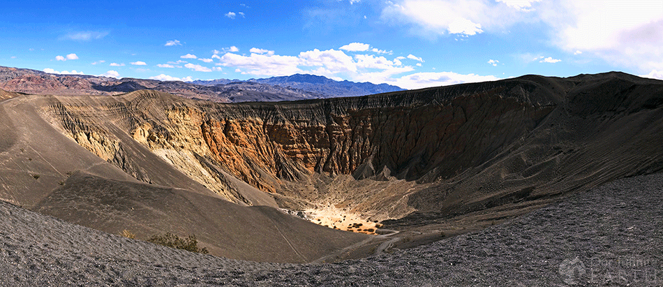
Hike the Ubehebe Crater
After you’ve solved the mystery of the traveling rocks, head to the Ubehebe Crater. The drive through the badlands is quite pleseant and there’s plenty to see at this massive crater.
Opt to walk down and back out of the crater (remember you’ll be going uphill in the heat on the way back). Alternatively you can circumnavigate the crater and check out the views nearby. Option 2 is my favorite, since you’ll have the best views.
Pro Tip: This is a great lunch spot too!
Distance from Racetrack Playa: 27 miles, 1 hour and 50 minutes.
Scour the Mesquite Sand Dunes
After a filling lunch, it’s time to see the most beautiful sand dunes in Death Valley. The Mesquite Sand Dunes are one of four dunes in the park, and the easiest to access.
Climb the dunes and sled down (a popular activity) or relax and soak in the views. The Mesquite Sand Dunes deliver some of the most incredible views in the park.
It’s easy to spend a few hours here, so take your time to explore or come back later in the evening.
Distance from Ubehebe Crater: 45 miles, 1 hour.

Additional Activities for Day 2 of this Death Valley Itinerary
If you’re a fast visitor or you’ve got extra days in your Death Valley Itinerary, these northern attracations are woth a look:
- Stovepipe Wells : Old town and mining community
- Harmony Borax Works: Mining operation.
- Grotto Canyon Hike : A technical, scrambly, 2-mile hike that offers a little shade and a lot of challenges
- Telescope Peak Trail: A challenging 14-mile hike that lets you see both the highest (Mt Whitney, 14,505 feet) and lowest (Badwater Basin (-282 feet) in the contiguous US.
- Aguereberry Point : A stunning viewpoint that requires a 4×4 vehicle. The views are better than Dante’s.
Tips for Visiting Death Valley
Before you head out on a Death Valley road trip, keep these tips in mind:
- The park is HUGE! Driving distances are vast and gas is hard to come by. Fuel up before you come in and take your time – the drives are wonderful.
- Bring plenty of water, shade, and salty snacks. There really aren’t any fascilities in the park (unless you want to grossly over-pay) so come prepared.
- Start early and head out in the evenings. If you’re hear during the hot months, definitely avoid the heat of the day, it’s oppressive.
- Cell service is mostly non-existant. Download offline maps with Google Maps before you head out, or pick up a National Geographic map of the area.
Come see one of the most unique places in America with this Death Valley itinerary. You’ll hit the highlights and feel like you’ve really gotten a flavor for the park.
Honestly, this place truly wowed me, and I’ve seen some amazing places. It’s worth it to at least spend one day in Death Valley to see what all the excitement is about.
Additional Death Valley Road Trip Resources
Planning a trip to Death Valley? Here are a few handy resources for nearby attractions:
- What to See in Red Rock Canyon
- The Most Challenging Hikes in California

Meg Atteberry
Meg is a long-time Colorado local and outdoor industry professional. She's spent the last 15 years hiking, climbing, mountaineering, and canyoneering all over Colorado, Utah, Arizona, and Nevada in search of the best views. She's written for Outside Magazine, REI, Backpacker Magazine, and appeared on the Weather Channel.
Let’s connect!

Meg aka Fox is a 30-something who's born to explore. Toddler mom, queer, and neuro-spicy her favorite things to do are climb in the alpine and camp in the desert. Her mission is to get you out on your greatest adventure.
Death Valley Driving Tour: Your 1-Day Road Trip Itinerary

Jason is an adventure travel writer with a passion for exploring the world's most beautiful and remote destinations.

Feel like driving through one of the hottest places on the planet? Sure, who wouldn’t?
Death Valley is a place like no other. From the rainbow-colored badlands to the expansive salt flats and looming mountains, this is one unforgettable road trip.
If you’re planning on visiting Death Valley, we’ve planned a 1-day Death Valley driving tour to help you see all the attractions and find the best parking spots in the park.
The Best Time To Visit Death Valley

Death Valley National Park is one of the hottest places on earth, so it’s best to avoid it during the warmest months (between May and September). At this time of year, temperatures soar to around 120 degrees Fahrenheit (48 degrees Celsius), which can make the tour pretty uncomfortable.
March and April are the best months to visit. Although they’re the busiest, the weather is best, and the Spring wildflowers are in bloom.
Nighttime temperatures are mild, and the park is the perfect place for star gazing, so if you can hang around until after sunset, it’s worth doing.
What To Expect On The Drive
Large areas of Death Valley aren’t accessible unless you’re an experienced backcountry driver with an off-road vehicle.
But don’t worry; there are paved roads from Beatty, NV, to Saline Valley Road, as well as from Las Vegas to Death Valley Junction. These are well-maintained and easy to drive, so our tour will stick to these.
The longest, most popular route starting from Las Vegas is easy to navigate, so you don’t need to stress about getting lost.
There isn’t anywhere to replenish water, food, or fuel along the way, so you’ll need to stock up in advance. There’s also next to no cell phone service, so be prepared to be off-grid while you’re in the park.
The National Park Service regularly updates its website about road closures and conditions in the national parks, so you can check on this before setting off.
How To Plan Your Trip
The longest route through Death Valley starts at Las Vegas. Leave via the I-95 and take the NV-373 south into California. It takes about an hour and a half to reach Death Valley Junction from here, where you can enter the park and start your Death Valley driving tour.
From Death Valley Junction, you’ve got a 100-mile drive through the valley, which takes around two hours without stops. The road follows the CA-190 the entire way, so it’s simple to navigate.
Check out this guide for more tips on places to stay, things to pack, and how to plan your one-day trip to Death Valley .
Gas, Food, and Lodging
You need plenty of water and food in your car to take this road trip. Although it’s easy to complete in a day, you need to plan for emergencies. If you break down, it can take a while for emergency services to reach you, so you’ll want plenty of supplies for the wait.
We recommend having a couple of days’ worth of food and water in your car to be on the safe side. You’ll also want emergency supplies like blankets, a first-aid kit, and flashlights in the trunk.
Gas is available in Panamint Springs, Stovepipe Wells, and Furnace Creek – it’s expensive, but these are the closest places to fill up before entering the park.
Fees and Passes
A car pass costs $30 and covers up to four adults entering the park in one car. You can pay online before you go, or you can grab a pass at the Furnace Creek Visitor Center.
Stops On The Tour

If you’re entering the park from the west, this is a full road trip that takes you past all the main attractions of Death Valley National Park.
Father Crowley Vista Point
As you drive toward the park, you’ll start the incredible descent of nearly 4,000 feet. Just as you start to drop, you’ll see the Father Crowley Vista, but keep your eyes peeled – it’s easy to miss. This overlook gives you an incredible view down into the valley, where you’ll see the sand dunes, mountains, and wildflowers (if you’re there in the spring).
Mesquite Flat Sand Dunes
Once you’re inside the national park, your first stop is the Mesquite Flat Sand Dunes. There’s a parking lot just off HWY 190 east of Stovepipe Wells. It’s a short hike to get to the dunes from the parking lot, but it’s worth it to see them up close.
Zabriskie Point
Head toward Furnace Creek and continue on HWY 190 until you reach Zabriskie Point. There are a few hikes in this area, but you can also just admire the view from the viewpoint near the parking lot.
The views here at sunrise and sunset are the most photographed in the entire park. Take a look at the badlands below, carved out by the powerful force of water. The salt flats are also visible in the distance, while the stunning Panamint Mountains form the backdrop.
Devil’s Golf Course

Head down Badwater Road until you get to Salt Pool Road. This is where you get to see the Devil’s Golf Course up close. It’s actually the dry bed of Lake Manly, where huge halite salt crystal formations now live.
The jagged salt spires form such rough terrain that an old guidebook once said, “Only the devil could play golf on such rough links.”
Listen closely, and you’ll hear tiny pops and pings, which are the salt crystals bursting in the heat.
Badwater Basin

A few miles from the Devil’s Golf Course, down Badwater Road, is Badwater Basin. This is the lowest point in North America, sitting at 282 feet below sea level.
From the viewing platform, you’ll see a pool of spring-fed “bad water”. The salt on the lake bed makes the water unfit for consumption, hence the name.
You can walk out onto the salt flats here if you head east from the parking lot.
Natural Bridge Trail
Head back onto Badwater Road and go north toward Furnace Creek. To the east, you’ll see the dirt road marked Natural Bridge Trail. It’s not suitable for most vehicles, but it’s a nice hiking trail if you want to stretch your legs.
The hike meanders through the forest for about a kilometer before it joins a service road for another half a kilometer to the natural bridge. It’s a short but steep switchback trail to the top of the bridge, but you can’t actually walk across it.
The bridge is a 51-foot cliff of rhyolite rock cut through by Bridge Creek. It’s a wonderful natural site to see, so worth the short hike out and back.
Artist’s Drive and Palette
Another short drive along Badwater Road takes you to a turnoff for Artist’s Drive. It’s a one-way road that can only be taken south to north.
Artist’s Palette is a long stretch of the Black Mountains that is famous for the beautiful range of colors it displays. The natural process of oxidation gives the iron compounds in the rock hues of red, pink, and yellow, while the decomposing mica (silicate minerals) gives off the greens.
Golden Canyon Interpretive Trail
On your way back toward Furnace Creek, you’ll spot a turnoff for Golden Canyon. This isn’t part of the road tour but a good opportunity for hikers who want to walk up to Zabriskie Point.
It’s a six-mile round trip, so make sure you plan plenty of time to do it and get back to your car to finish your tour. You’ll need some decent trail shoes and plenty of water if you are going to take on this hike. But the views are incredible, and it’s a romantic hike to take with a partner.
20 Mule Team Road
The final stop on our Death Valley driving tour is 20 Mule Team Road. This road is iconic in Death Valley National Park, first used in 1883 by mule teams hauling borax 165 miles to the railway in Mojave.
It’s an unpaved road through the colorful badlands. If you’re a Star Wars fan, you might recognize this part of the valley as the landscape around Jabba the Hutt’s palace in Star Wars Episode VI.
After you’re done admiring the view, you can exit the park either east or west using HWY 190.
Avoid Making These Mistakes

It’s easy to forget how dangerous Death Valley actually is, but people have died in the park due to heat exhaustion. Here are a few mistakes to avoid to help you stay safe and have a great trip.
Pack enough water
We’ve said it once, and we’ll say it again – you need a few days’ worth of water for a Death Valley road trip. It’s easy to take unused water home with you, but you don’t want to run out and wish you had more.
Keep applying sunscreen
Many people forget about sun protection because they spend a lot of their day inside a car. However, UV rays are still dangerous through car windows, even if they’re fitted with UV-blocking technology. Keep reapplying sunscreen throughout the day and take breaks in the shade if you’re feeling hot.
Don’t get stuck on one-way roads
There are a couple of one-way roads in Death Valley, and it’s irritating driving up to one only to realize you’re at the wrong end. Whichever way you plan on entering the park, map out your entire road trip and check for one-way roads to ensure you plan a nice, smooth loop.
Enjoy Your Death Valley Driving Tour!
A trip to Death Valley requires a little more planning and safety considerations than other national parks, but it’s definitely worth the visit.
There’s no other place like Death Valley on Earth, and you’ll feel like you’ve stepped into a sci-fi movie. Whether you plan on taking hikes or just want a fun one-day road trip, enjoy your death valley driving tour and stay safe out there.
If you need equipment for hiking, running, or climbing through icy conditions and deep snow, this post will show you whether you need microspikes or crampons for the trip.
Hiking Kern Hot Springs High Sierra Trail: A Backpacker’s Guide
The Ultimate John Muir Trail Gear List
Leave a Comment Cancel reply
Save my name, email, and website in this browser for the next time I comment.
Reach out to us for sponsorship opportunities
We're always looking to grow our reach and collaborate with other influencers within this exciting space.
© 2024 The Roam Wild

A One Day Road Trip Through Death Valley National Park: 10 Things To See
Drew Robinson | April 10, 2018 April 10, 2018 | National Parks
Death Valley is a desert valley located in Southeast California alongside the Nevada border. Death Valley is home to the world renown Death Valley National Park and the Badwater Basin, the lowest elevation in North America at 282ft. Death Valley is also well know as being one of the hottest places on earth, with the town of Furnace Creek registering an air temperature of 134 °F back in 1913.
Death Valley National Park is the perfect place for desert lovers looking to explore the outdoors. With wildflowers, scenic hikes, sand dunes, dry lakes beds, mountains, and more, one could easily spend years in this park and never come close to seeing it all. Before attempting to spend a lifetime, many visitors budget a single day while taking road trips through California and Nevada. In this guide, I’ll provide 10 must-see attractions for visitors planning a one day road trip in Death Valley National Park.

Death Valley Road Trip Map
For this one day road trip, my directions will start from the west via Lone Pine, CA, and will require a very early start. From Lone Pine, you’ll have views of the 14,555ft Mt. Whitney, the tallest point in the contiguous United States. If you’re looking for a great place to camp before driving through Death Valley, check out my guide for Alabama Hills .
As you can see in the map below, you’ll take HWY 136 East out of Lone Pine and then join HWY 190 East into Death Valley National Park. You’ll want to be driving away from Lone Pine no later than 7:00 to see all of the things on my one day itinerary.
– Total Road Trip Distance: 163 Miles, not including the drive out of park – Total Estimated Drive Time: 3 hours 40 minutes, stops not included
When to Visit
As I mentioned above, Death Valley is a desert and one of the hottest places on earth. Plan your visits accordingly and avoid the summer months. The months from October to April are ideal, with warm days and cool nights. The deserts are also prone to flash floods during storms, so keep a close eye on the weather forecast before driving into the park.
Gas, Food, and Lodging
You’ll want to fill up on gas before entering the park. Gas is available in Panamint Springs, Stovepipe Wells, and Furnace Creek, but you’ll pay a pretty penny for it.
Food, water, and lodging are also available in these areas, but make sure to come prepared with a few days worth of food and water in your vehicle.
Fees and Passes
The standard price for a vehicle to enter Death Valley NP is $25 for a 7-day pass. You can also buy a National Park annual pass for $80. See more at NPS.gov .
Death Valley One Day Road Trip Itinerary
1.) father crowley vista point – mile 42.
As you drive towards Death Valley National Park on HWY 190 from Lone Pine, you’ll begin a descent of nearly 4000ft! Just before the highway starts to lose elevation in a hurry, you’ll see Father Crowley Vista just off of the road. Keep your eyes peeled here, as it’s easy to miss. From this overlook you can see down into Death Valley, with sand dunes, mountains, and lava flows before you.

2.) Mesquite Flat Sand Dunes – Mile 83
Our second stop on this Death Valley road trip is the first within the National Park itself, the iconic Mesquite Flat Sand Dunes. The parking lot for Mesquite Flat Sand Dunes is located off of HWY 190 just east of Stovepipe Wells. You can see the sand dunes from the parking lot, but you’ll have to take a little hike out onto the sand if you want to see them up close.

3.) Zabriskie Point – Mile 110
After leaving Mesquite Flat Sand Dunes, head towards Furnace Creek and continue on HWY 190 to Zabriskie Point. If you look at my map, you’ll see that this could also be done at the end of this road trip, but I have it here at the beginning because it photographs better early in the day. There are a few hikes you can do in this area, but for this road trip, I just walked to the overlook viewpoint near the parking lot.

4.) Timbisha Village Frybread Tacos – Mile 115
After leaving Zabriski Point, double back to Furnace Creek. If you’re looking to grab a bite to eat, stop by the Timbisha Village Frybread restaurant in Indian Village. The frybread tacos and shaved ice are amazing here! You’ll also get a chance to learn about Death Valley from the perspective of the Timbisha Shoshone Indians who lived in the area before miners, pioneers, and settlers took it from them.

5.) Devil’s Golf Course – Mile 124
After stopping for an early lunch at Timbisha Village, you’ll head down Badwater Rd until you reach Salt Pool Rd. On Salt Pool Road you’ll get to see Devil’s Golf Course up close. This area is a dry lake bed (Lake Manly) of large halite salt crystal formations, and received its name from a line in a National Park service guide book that read “Only the devil could play golf” in this area.
The Pacific Coast Borax Company extracted resources in the Death Valley area before it became a protected National Park in 1934. Their prospecting in this area found that the salt and gravel of Devil’s Golf Course extended to a depth of more than 1000ft in some areas!

6.) Badwater Basin – Mile 135
From Devil’s Golf Course, you’ll drive a few more miles on Badwater Rd to reach the Badwater Basin. This point is 282ft below sea level, the lowest point in North America. Next to the Badwater Basin platform, you’ll see a pool of spring-fed ‘bad water’ from which the site gets its name. The salt on this dry lake bed makes the water unsuitable for human consumption. You can walk out onto the salt flats by heading east from the parking lot.

7.) Natural Bridge Trail – Mile 137
After visiting the Badwater Basin, get onto Badwater Rd and head back north towards Furnace Creek. On the east side of the road, you’ll see a dirt road for Natural Bridge Trail. This road is deeply rutted and can be very rough on vehicles without enough clearance.
At the end of the dirt road, you’ll see a dirt parking lot. This hike is 1-mile out and back and gains a little over 200ft of elevation. See my hiking track on Strava .

8.) Artist’s Drive and Palette – Mile 148
After the short hike to see Natural Bridge, you’ll return to Badwater Rd for a short drive before seeing the turnoff for Artist’s Drive. This road is one-way and can only be driven from south to north. This is why I have it featured after the visits to Devil’s Golfcourse, Badwater Basin, and Natural Bridge.
The highlight of Artist’s Drive is a stop at Artist’s Palette. Artist’s Palette is a stretch of the Black Mountains that is famous for the variety of rock colors on display. Oxidation gives iron compounds hues of reds, pinks, and yellows. Decomposing mica produces the greens.

9.) *Golden Canyon Interpretive Trail
As you make your way back north towards Furnace Creek, you’ll see a turnoff for Golden Canyon. This trailhead is perfect for hikers looking to complete an approach hike to Zabriskie Point. I didn’t have time on this visit, but if you can squeeze in a 6-mile round trip hike, the views are not to be missed!

10.) 20 Mule Team Road – Mile 163
The final stop on this one day Death Valley road trip is back on HWY 190 for the 20 Mule Team Road. This road is famous in Death Valley. From 1883 to 1889 mule teams hauled borax 165 miles to the railway in Mojave on ten day journeys. You can read more about this road on NPS.gov .

The stop at 20 Mule Team Road concludes this one day road trip itinerary for Death Valley National Park. You can exit the park via the east or west using HWY 190. I hope you enjoy your time in the park!
Share This Post!

Share this:
- Click to share on Facebook (Opens in new window)
- Click to share on Pinterest (Opens in new window)
- Click to share on Twitter (Opens in new window)
- Click to email a link to a friend (Opens in new window)
Related Posts You Might Like
Gear review: five ten access knit hiking shoes, 8 things to do in hoi an vietnam, 7 thoughts on “a one day road trip through death valley national park: 10 things to see”.
Death Valley National Park is on my bucket list to visit within the next 2 years. Everyone thinks I am crazy for wanting to explore there, but all the pictures I see are just so beautiful!
It’s one of my favorite National Parks. Hopefully you can visit soon!
DV is a wonderful place. I think your 10 site one day visit is a good introduction to a very special place, that has many nice hikes. It and JTree are my favorite parks but they are getting visited a bit more (to much. There is also many Ghost towns to visit for a two day trip.
Looks like I’m 8 months behind you. Dropping a quick thank you. My friend and I love to camp and are losing weight for better health. Thank you for the information, we’d like to explore this beautiful area safely. May I ask we’ve started research, but are asking feedback on campsites if you have time please. Bests, great site!
You can find all info on Death Valley camping here: https://www.nps.gov/deva/planyourvisit/camping.htm
I want to do a drive only tour with my 94 year old dad. He can walk, but not more than about 1/4 mile. We are coming from Las Vegas in mid November and will want to stay at a lodge, before continuing on to the SF Bay Area. Any suggestions?
- Pingback: Exploring the Feasibility and Essence of Driving Through Death Valley: Can You Drive through Death Valley?
Leave a Reply Cancel reply
This site uses Akismet to reduce spam. Learn how your comment data is processed .
Discover more from Trail to Peak
Subscribe now to keep reading and get access to the full archive.
Type your email…
Continue reading
- Destinations
- Backpacking
- Caving & Spelunking
- Guided Tours
- Luxury Resorts
- On The Water
- Scuba Diving & Snorkeling
- Camping & Backpacking
- Environmental Impact
- Conservation

3-Day Vegetarian Backpacking Meal Plan Ideas

Adventurous Things To Do In Belize

Best Grand Staircase Escalante Hikes

How to Train for High Altitude Hiking
- Death Valley
Death Valley 1-Day Road Trip
Planning a road trip to see all of Death Valley in one day is impossible. It’s one of the biggest parks in the country as 140miles long and is full of dirt roads, so even driving the length of it will take up a good chunk of your day. But if you only have one day and want to check out some of the highlights, then we’ve got an itinerary for you!
To make the most of your 1-day trip and to maximize your time you’re going to want to stay in the southern end of the park where there are paved roads and the majority of the famous attractions are. Unfortunately, this means more crowds and tourists as this is the most popular area, so if you’re trying to avoid the crowds, I recommend taking more than one day and going to the places that you need a 4wheel drive vehicle to get to.
This trip is very ambitious (I’m an over-planner and try to pack in as much as possible) and doesn’t give you a lot of time at each location, but will give you a great overview of much that the park has to offer. Depending on how much time you want at each place, you might need to skip 1-2 or these to make your day, but I’ve packed in as much as possible so that you have options to choose from and have also noted the best/must see stops:
Table of Contents
Know Before You Go
- Start EARLY – like be in the park at 7am in order to fit everything in
- Death Valley gets extremely hot over the summer – by May temperatures get into the 100s during the day, and with no shade, you’re at the mercy of the sun. It holds the record for the hottest air temperature ever at 134F, so try to come in early spring or late winter. Here’s more info on the best time to visit .
- There is little to no cell service in the park, and even if you’re staying at a hotel, Wifi isn’t reliable. Make sure to have planned out your trip before entering the park.
- There’s no public transportation in the park – you will either need your own car or will need to rent a jeep or a bicycle from Furnace Creek.
- Furnace Creek and Stovepipe Wells are the only “civilized” areas of the park – meaning there’s food, water, gas, etc. When out in the rest of the park, you’re on your own.
- Bring snacks! There aren’t a lot of food options in the park and what is there tends to be crowded with long wait times.
- There is no entrance gate for Death Valley. Park entry fees ($35 per car) can be paid at the ranger stations or at any of the self-pay facilities around the park.
- DO NOT get gas in Shoshone or Panamint Springs – the prices are at least $1/gallon more than even what’s available in the park.
One Day Road Trip Itinerary
For this itinerary, we recommend starting at the southern entrance to the park and coming in on Rte 178 from Shoshone, but if you’re coming from another direction, it can completely be reversed too!
#1 – Ashford Mills Ruins

#2 – Badwater Basin
#3 – Devil’s Golf Course

#4 – Artists Drive & Palette

#5 – Zabriskie Point
#6 – Twenty Mule Team Canyon

#6 – Dante’s View

#7 – Harmony Borax Works
#8 – mesquite flat sand dunes.

#9 – Mosaic Canyon

#10 -Leadfield Ghost Town

If You Have Extra Time or Another Day
Full Death Valley Trip Planning Guide + Map Here
Where to Stay and Eat
If you’re planning on staying in or nearby the park in order to start on this 1-Day road trip early the next day, we’ve put together a huge list of all of the places available to stay from hotels to campsite etc. available here.
As far as places to eat – it would be best to bring your own food with you. There are a few places to eat in Stovepipe Wells and Furnace Creek, but the limited number of restaurants tend to be understaffed and full of tourists, so you can expect a loooong wait. There’s a general store at each location too, but the goods here are again limited and over-priced. Also with this itinerary, you won’t have time to stop and get food if you’re trying to visit each location, so eating on the go is your best option.
RELATED ARTICLES MORE FROM AUTHOR
Leave a reply cancel reply.
- Destinations Map
- Conservation & Awareness
- Latest Posts
We Are Travel Girls
A Community Created To Inspire, Connect, Educate & Empower Female Travelers
CALIFORNIA , ROAD TRIP , UNITED STATES · April 11, 2019 Last Updated on March 11, 2024
5 THINGS TO KNOW FOR A DEATH VALLEY ROAD TRIP
This post may contain affiliate links. As an Amazon Associate I earn from qualifying purchases. We may receive a small commission when you make a purchase using our link.
California has no shortage of beautiful national parks, but a truly special and quirky one that you must check out is Death Valley. After a mere 24-hour visit to this strange place in the northern Mojave Desert with its harsh desert climate, unique history, and varying topography, I fell in love.
As much as 91% of this park is considered a designated wilderness area, and Death Valley is recognized by UNESCO as an International Biosphere Reserve because of its unique ecosystem.
The Timbisha Shoshone tribe has also resided in the heart of Death Valley for more than 1,000 years. This otherworldly destination has everything from Wild West ghost towns to crazy mineral deposits in mountains that make your surroundings feel like they were splashed with a paintbrush and are more vivid than you can possibly imagine. Death Valley is also an incredibly beautiful place to stargaze.
While this park is definitely something you must visit if you’re in California or Nevada (it borders both), there are some key things to keep in mind when you are planning your trip to Death Valley.
This should be no surprise given the name, but Death Valley is one of the hottest places on earth! In 1913, this valley had a record world high temperature of 134 Fahrenheit (56.6 Celsius).
If you visit, be sure to pack lots of sunscreen and water, and check the weather before you go. We visited in January, which was a lovely (if not slightly chilly) time to go with an average high of 67 F/19 C. I would highly recommend visiting between November and March, and am begging you—please do not try to go during the summer months of May-September (high of 117 F/47 C!).
Not only will it be incredibly hot, but a lot of facilities and restaurants may be closed due to the extreme heat. It is much more temperate and enjoyable to visit between November (high of 77 F/25 C) and March (high of 82 F/27 C).
Death Valley Size
At 3.4 million acres, Death Valley is the largest national park within the contiguous United States (the four that are technically larger are all in Alaska). Driving from one popular spot in the park to another could take you 2+ hours, so make sure to plot out your points of interest wisely!
During our 24 hours here we missed some spots we would have liked to see, but it was worth it to spend more time in the places we selected (and now we have more sites to discover the next time we visit!). From salt plains to towering snowy cliffs and volcanic ruins, there’s something for everyone here.
On the same note of how large Death Valley is, you must be conscientious of how far it is from civilization as well. It’s nearly a 4-hour drive from Los Angeles to Death Valley, and about a 2-hour drive from Las Vegas. You should definitely make sure to budget enough time to get here, as embarking on a trip to Death Valley is akin to doing a long desert road trip!
Cell Reception
You will have patches here in there where bars magically appear on your cell phone and you can actually make phone calls and check emails. All in all, however, you’ll find that driving through Death Valley will mean that you’re mostly off the grid.
Given this, I would advise that you make sure that you download offline maps or plot out your stops ahead of time. Oh, and maybe you should download a bunch of podcasts, audiobooks and music as well!
Subscribe to get our FREE eBook with tips on saving money when you travel!
Where To Stay In Death Valley
Hotel and restaurant options here are limited, and you should research and book in advance. There are a few campsites (Furnace Creek, Mesquite Spring and Wildrose) and a few hotels ( The Oasis , The Ranch at Death Valley , Stovepipe Wells Village and Panamint Springs ).
Our preference was to stay at a hotel, so we went with the adorably sophisticated and charming Inn at the Oasis .
Where To Eat In Death Valley
For food, let’s be honest, you’re not going to Death Valley to try some delicious desert cuisine. There are food options for sure; grab a drink at the Badwater Saloon, a nice dinner at The Inn Dining Room , farm-to-table fare at Amargosa Café , unique local Native American food at Timbisha Tacos or a simple burger or hot dog at the 19 th Hole, aka the lowest altitude golf course in the world!
However, good food is pricey, and many of the restaurants have slightly unpredictable hours. Whenever you set out on this road trip, know that you have options, but also just make sure to pack plenty of trail mix, dried fruit or other snacks!
Stops To Include On Your Roadtrip
This is the part you’ve been waiting for. Death Valley has no shortage of breathtaking views, from sand dunes and salt flats to volcanic mountains and mining site ruins. Here are some of my favorite things to see.
Zabriskie Point (36.4201° N, 116.8122° W)
This quintessential Death Valley spot is easy to get to with a parking lot and a ramp that leads right up to the main viewpoint. The vista point was originally constructed by the Pacific Coast Borax Company in the 1920s and was named after Christian Zabriskie—the company’s vice president. It’s an incredibly popular photo spot for sunrise, but it’s beautiful at any time of the day.
We went here twice when we were in Death Valley because of the ease of access from The Oasis, and it did not disappoint on either visit! Also, fun fact: Zabriskie Point is the destination featured on U2’s 1987 album “The Joshua Tree” (yes, ironically NOT from Joshua Tree National Park, although they did shoot there as well).
From Zabriskie Point , you can see many beautiful views in Death Valley, from the golden badlands to the cliffs of Red Cathedral and the vivid mountain range behind Artist’s Palette.
Badwater Basin (36.2461° N, 116.8185° W)
Who says you need to go to Bolivia for beautiful salt flats? At -282 feet (86 meters) below sea level, Badwater Basin is the lowest point in North America, and once was thought to be the lowest point in all of the Western Hemisphere.
It’s a bit of a walk via a wooden boardwalk to get to most beautiful salt-covered stretches of the basin but is 100% worthwhile. Because no water can flow out of the basin, it gets trapped and evaporates into the hot air, leaving behind salt mineral deposits that crack to form polygonal shapes.
Supposedly, the basin gets its name from an unknown prospector who, while exploring the area in search of valuable minerals, tried to lead his mule to drink the water. After the mule refused to drink the salty, stagnant water, the prospector deemed the area “Badwater,” since it was not drinkable.
Artist’S Palette & Artist’S Drive (36.32995° N, 116.82995° W)
One of the most fun drives you can do in Death Valley is along the Artist’s Drive. This 9-mile (14.5-kilometre) long one-way drive will take you weaving through colorful hillsides of green, white, yellow, purple, red and blue.
At the most popular point of the drive, there is a small parking lot that you can turn into to walk out to Artist’s Palette , where the most vivid colors are.
The splashy and unique colors are formed by minerals oxidizing in the rock! Iron-rich hematite and oxides create the red/pink/yellow, mica deposits lead to tinges of green and manganese forms purple.
Dante’s View (36.2211° N, 116.7256° W)
At 5,476 feet (1,669 meters) high, Dante’s View is one of the prettiest places to watch the sunset in Death Valley. Watching the sun disappear behind the snowy Panamint Range was a truly marvelous thing to see, and the view of the basin is also something to behold here. This spot was actually used as a shoot location to portray Tatooine in the 1977 “Star Wars” film!
Other spots that we did not make it to but that I’ve heard are must-sees include the iconic Mesquite Flat Sand Dunes, the historical Keane Wonder Mine, the eroded and jagged rocks of the Devils Golf Course, remnants of a volcanic explosion at Ubehebe Crater and the beehive-shaped old fuel facilities of Charcoal Kilns.
Pack Your Bags And Go!
A lot of people prioritize Joshua Tree National Park and Yosemite National Park when they visit California, which are both incredibly beautiful in their own rights. But few places have surprised me as much as Death Valley did.
This otherworldly land of extremes will make you feel like you’re on a different planet and is well worth a weekend or even a weeklong experience. Come with your loved ones, see some wildlife (despite its name, Death Valley has a surprising amount of wildlife—we saw a few coyotes, and there are also bighorn sheep, tortoises, jackrabbits, plenty of birds and reptiles, fish and many more creatures!), learn about some historical mines and embark on some beautiful hikes.
Prepare for endless exploration and diversity of adventure when you visit—you won’t be disappointed!
We hope that this article has helped inspire you to take a road trip through Death Valley. If you have any questions about the destination or have your own travel tips to share please leave these in the comments below.
Want to share your own travel tips by guest writing for We Are Travel Girls? Go to our Contribute page for guidelines and to submit your article.
Subscribe to get access to our FREE eBook with tips for saving money when you travel!
Places To Stay In Death Valley, California
- The Oasis Inn at Death Valley
- The Ranch at Death Valley
- Death Valley Inn & RV Park
- Find the best price on hotels in Death Valley, California
- Sign up to AirBnB with this link and receive a US $35 off your first booking
Read More California
- Death Valley California, A Photographers Paradise
- 5 Days On The Pacific Coast Highway
- 5 Things To Do In Healdsburg, California
- 10 Awesome Experience Not To Miss In San Francisco
We Are Travel Girls Contributor Cherise Masukawa of CheriseAndShine.com Connect with Cherise Instagram | Facebook
Pin For Later
This website may use affiliate links in our articles. Please see our Disclosures for more information.
You’ll Also Love
September 4, 2019 at 3:13 am
Thank you so so much! Can you please give me the coordinates of the place you are on the cover?? Thanks! xxx
Allison Hughes says
November 15, 2022 at 4:25 pm
Very informative! Thank you!
Leave a Reply Cancel reply
Your email address will not be published. Required fields are marked *
Notify me of follow-up comments by email.
Notify me of new posts by email.
- Travel Girls Getaways
- DESTINATIONS
- TYPE OF TRAVEL
- TRAVEL RESOURCES
- AMBASSADOR PROGRAM
- TRAVEL GIRLS GIVING
Get Access To The Travel Resources Library
Subscribe to receive free access!
- Work With Us
- TESTIMONIALS
- DISCLOSURES
- TERMS OF SERVICE
- PRIVACY POLICY
- ACCESSIBILITY
COPYRIGHT © 2023 WE ARE TRAVEL GIRLS
Exclusive Member of Mediavine Travel

- Scenic Drives
- Road Trip Planner

- Suggestion Box
- Vista Points
- Campgrounds
- Charging Stations
Home ▼ » California Scenic Drives and Road Trips
Share Link Open in new window
Death Valley Scenic Byway
The Great Desert
- Download Map/GPS
- Send to Phone
- Print Directions
Related Drives
- Share Pictures
Our free Road Trip Planner will reverse the route and include the places of interests. Click the “Add to Road Trip” above to start planning your next road trip.
Send this link to your phone. Standard text messaging rates apply.
Get directions from your start address to the beginning of and including this scenic drive. Choose either an alternate ending or same as start.
- Starting: * Use GPS
- To: Death Valley Scenic Byway
- Ending: Same?
Have more destinations? Use our free Road Trip Planner to completely plan your adventure. Click the “Add to Road Trip” above to start planning your next road trip.

Death Valley is the great desert, facing some of the highest temperatures and lowest elevation in this area of the world. These extremes bring extraordinary scenic beauty.

This scenic drive begins in Olancha at the intersection of US-395 and CA-190, and heads to Shoshone at the intersection of CA-190 and CA-127, of which following it to the south will bring you to I-15.
Heading west on CA-190 from Olancha, the drive heads through the Owens Lake Bed and then starts climbing up the Argus Range until you enter the Death Valley National Park. The drive continues into the park’s Panamint Valley, where you will see the Panamint Dunes in the distance.
After the climb up, keep an eye out for Wildrose Road heading to Aguereberry Point (V1) . At 6,433 feet of elevation, Aguereberry Point provides an incredible view of Death Valley. After 11 miles on Wildrose Road, turn onto the dirt Aguereberry Road for the final 6 miles.
Continuing east on CA-190 for 9 miles, a 2.3-mile side-trip will bring you to Mosaic Canyon (H1) , a short and easy walk in Death Valley through a narrow, multicolored, layered marble that was carved by water.
Where CA-190 heads south in 7 miles, consider a side-trip on Scottys Castle Road, which will bring you to both Scottys Castle (M1) and Ubehebe Crater (H2) . Scottys Castle is a Spanish Villa built by Albert Johnson in the early 1900s at a cost exceeding $1.4 million. Today the castle is open for tours.
The Ubehebe Crater (H2) is a field of steam explosions that carved craters known as maars. The Ubehebe Crater was the largest and last formed in the area.
Back on CA-190, 4-miles from the Scottys Castle Road turn-off, the Salt Creek Interpretative Trail brings you to one of the few places in Death Valley that has a spring. Although the water retreats in the height of summer, the stream is home to the endangered pupfish. Up ahead, the Furnace Creek area has natural springs which gush more than 600 gallons of water a minute, creating a very green and lush environment. The Furnace Creek Visitor Center and Museum (M2) is a great place to get information or to learn about the area.
After Furnace Creek, consider a side-trip on Badwater Road (T1) bringing you to a lake saltier than an Ocean and is 179 feet below sea level. On the way there, you will pass Golden Canyon which is worth a stop. Artists Drive (T2) is a 9-mile loop also off of Badwater Road which leads to a colorful blend of minerals, sediments, and volcanic materials.
Back on CA-190, Zabriskie Point (T3) will be on the right in 4-miles from Badwater Road, where you can view the ancient lakebeds. From here, you can continue on a gravel road down to the badlands and the Twenty Mule Team Canyon.
Heading west on CA-190, you will soon arrive at Dante’s View (T4) . A 13-mile windy and steep stretch of road will reward you with a spectacular view of Death Valley. With the Badwater Lake below and the Panamint mountains ahead, this is a must see.
The scenic drive completes as the CA-190 ends. From here, you can head south on CA-127 to I-15. Or consider a trip to the ghost town of Rhyolite, Nevada. Explore the dilapidated ruins and remnants of saloons, hotels, homes, a bank, train station and more in what was a thriving mining town in 1904. Don't miss the eerie and whimsical sculptures nearby at the Goldwell Open Air Museum. The museum is free and open 24/7.
- More California scenic drives
- Find more scenic drives
- Plan a Road Trip
- Recommend a Stop
- Gas Calculator
- Jump to the map
myscenicdrives.com
How it works.


Ultimate Death Valley Road Trip: A 5-Day Itinerary from LA

Death Valley has been on my bucket list for a long time, so I was very excited when I was presented with the opportunity to road trip from LA to Death Valley thanks to my friends at Visit California. You can use their Road Trip Finder search tool to plan your own epic road trip, whether it’s to Death Valley like mine or other awesome spots like the North Coast, Palm Springs, or Yosemite, just to name a few! My trip was based upon the Discovering Death Valley itinerary and expanded, so check out my itinerary below for the ultimate Death Valley adventure starting from Los Angeles.
Disclaimer: This post is in partnership with Visit California. As always, all opinions are my own.
Table of Contents
Day One: LA to Lancaster
For the first day, start from LA (we flew into LAX and went straight from there after picking up our rental car) and take State Highway 14 up to Vasquez Rocks Natural Area Park near Agua Dulce. The drive out is 52 miles from LAX, and takes about an hour to 1.5 hours depending on LA traffic. The 932-acre park is most famous for its spectacular rock formations that have been the backdrop numerous Hollywood movies and TV shows over the years, such as Blazing Saddles, Bill and Ted’s Excellent Adventure, and Star Trek! Once you’ve finished up at Vasquez Rocks Natural Area Park, drive 30 minutes (27 miles) to Lancaster for the night.

Day Two: Lancaster to Ridgecrest
For the first stop of the day, head just a short drive from Lancaster to Saddleback Butte , a hidden gem of the area filled with Joshua Trees and scenic views. You can choose to either hike the 3.8 mile out and back trail (which has a 980 feet elevation gain), or just take in the views from the Visitor Center for a quick photo op.

Then, take Highway 14 up to Red Rock Canyon State Park , near Cantil. You’ll probably want some time here to explore and photograph, because the entire area is absolutely gorgeous and filled with red rocks, just like its name would suggest. I really don’t know how this State Park isn’t more popular (we hardly saw any visitors there!) because it is some of the most stunning geology you’ll find in Southern California. If you have the time, you can take hikes through Hagen Canyon and Red Rock Canyon. Or, if you’re only there for a quick stop, take a drive around to find Joshua Trees and beautiful red rock cliff faces. Some Instagrammable photo spots you can find around Red Rock Canyon State Park include Turk’s Turban (below, left), Camel Rock, Hagen Canyon, and the Red Cliffs Natural Area just off the highway (below, right). Once you’re done at the park, head to Ridgecrest to spend the night.

Day Three: Ridgecrest to Death Valley via Alabama Hills
Start the morning off with a drive about 45 minutes out to the surreal landscape that is the Trona Pinnacles . The road out to the Trona Pinnacles in unpaved and a bit rough (it’s a five-mile-long dirt road), so budget plenty of time to get there if you’re not in a 4WD vehicle since you’ll have to go very slow. In general, having a 4WD car for this itinerary would be helpful, since it’d allow you to go to certain places in Death Valley that you can’t go to otherwise (like the Racetrack Playa), and to more easily get to Trona Pinnacles, but it’s not 100% necessary and we did do the trip in a normal SUV. The Trona Pinnacles are made up of 500 oddly shaped spires that rise up to 140 feet above Searles Dry Lake, making for a bizarre landscape that has featured in vintage sci-fi flicks, and more recently, the HBO TV show Westworld. Make sure to take some time to drive around the pinnacles to see them from different perspectives! One of my favorite views was from the top of the road on the drive in.

From Trona Pinnacles, we drove about two hours up Highway 395 to Lone Pine, featuring Alabama Hills and the Mount Whitney Portal , to explore for the afternoon. Since this is a bit out of the way, you can choose to skip this part and instead head straight up towards Highway 190 and Death Valley for the fastest route to the national park. Once you reach Lone Pine, depending how much time you have, you can drive 20 minutes up Whitney Portal Road to reach the Mount Whitney Trailhead. Here, you’ll find the main trailhead to hike Mt. Whitney, which is the highest point in the contiguous United States, as well as routes for shorter hikes, such as the 5.1 miles out-and-back trail to Lone Pine Lake.

Another option is to drive around Movie Flat Road for scenic views around Alabama Hills. You can make stops at several of the arches around the area, such as Mobius Arch (which is also a great spot for astral photography!), Boot Arch, and of course, the Insta-famous shot down Movie Road for the perfect desert photo op. You’ll probably recognize this Movie Road shot (below) from all over Instagram, and it is especially popular as a sunrise photo spot. Because of the timing of our road trip, we actually visited here for sunset, which can be another good time to shoot here as the lighting isn’t as harsh.

Once you’re done exploring everything around Lone Pine, head out towards Death Valley – the drive can take 1-2 hours depending where you plan to stay in the park. For our visit, we stayed at The Inn at the Oasis at Death Valley in Furnace Creek, a historic, 4-diamond hotel that is perfect for anyone looking for a bit of luxury during their Death Valley stay.
Day Four: Explore Death Valley
Yay, you’ve made it to Death Valley! At this point, you can either extend your itinerary to longer than five days if you’d like more time to explore Death Valley National Park, or try to fit as much as possible into a day-and-a-half whirlwind tour of the park. If you go from sunrise to sunset, you can fit in quite a lot! for our trip, we spent two full days inside the park, and were pretty much able to do everything we wanted (there were places we couldn’t go without a 4WD vehicle) in that amount of time. Quick note – even if you don’t drive a 4WD car in, there are options for Jeep rentals inside the park if you’d just like a day rental to make it out to spots like the Racetrack Playa!

Death Valley has so many iconic photo spots, it’s hard to pick what to see in Death Valley if your time there is short. That said, I’ve narrowed it down to what I feel are the major highlights of the park to make the most of your time there. Here are 6 of the best photo spots to visit in Death Valley National Park!
Zabriskie Point
I loved Zabriskie Point so much that I think we went back there three times in total during the two days we visited the park. It also helped that it’s such a short drive from where we were staying at the Oasis at Death Valley! We visited in the afternoon, at sunset, and at night, and of the three, my favorite was definitely sunset. As you can see below, sunset is definitely one of the best times to visit Zabriskie Point, as the sun lights up the hills in shades of orange and pink. But, make sure to stick around for awhile longer, as the sky comes alive with the Milky Way after dark, and Zabriskie Point is a great spot for shooting the stars.

Depending on the time of year, you might even be lucky enough to capture the Milky Way core right above you, like I did in the shot below (right). What I love about Zabriskie Point is how much there is to shoot there in all directions. You can take photos of the point itself or overlooking Golden Canyon, or walk out to the end of one of the paths for great scenic portrait spots. The whole area is just stunning!

Artist’s Palette
All of Artist’s Drive is filled with beautiful photo spots, but the best of all has to be Artist’s Palette, towards the end of the loop road. From the parking lot, you can get amazing shots overlooking the rainbow hills, aptly named for the pastel colors formed from minerals that look like an artist splashed paint all over the mountains. It is especially beautiful when golden hour lights the whole area up. If you have the time, it’s well worth it to walk down through hills and up over the ridges for unique views and up close perspectives of all the colors.

Badwater Basin
Badwater Basin is home to the famous saltwater flats of Death Valley, and is the lowest point in North America, coming in at 282 feet below sea level! It can take awhile to walk out to where the salt flats are less trodden on, so make sure to budget time to walk out there and bring plenty of water and shade with you. If you’re visiting in the summer, go as early as possible, as it is dangerous to walk out onto the flats in the afternoon when temperatures soar above 100 degrees and the sun beats down on you. We visited in September, when the temperatures are much more mild, so it was easy enough to visit during the middle of the day. Pro-tip: bring props out with you to take fun photo ops that take advantage of the vast flatness and play on perspectives!

Mesquite Flat Sand Dunes
While these aren’t the tallest sand dunes inside Death Valley, they are the most accessible, located just outside Stovepipe Wells. The dunes rise up to 100 feet, and get their name for the mesquite trees located throughout the dunes. Hiking through sand can be difficult, so make sure to plan accordingly, especially if you’re wanting to walk out towards some of the taller dunes. That said, you can get great shots from just off the parking lot, but the trade off is tons of footprints from other visitors. If you want photos clean of footprints in the sand, you’ll have to spend 30 minutes to an hour hiking out to where it’s pristine. In summer months, you’ll also want to start your hike as early as possible, as it’s not safe to hike when temperatures are high. Bring plenty of water and a hat! This is also a great location for sunrise or sunset, and golden hour sees the sand bathed in gold.

Dante’s View
If you’re looking for a great overlook from a high vantage point, it’s hard to beat Dante’s View. The viewpoint is over 5000 feet above sea level with panoramic sights over Badwater Basin and the Devil’s Golf Course – no hiking required! Fun fact: in the original Star Wars, they filmed the scene here on Tatooine where the characters are looking down on Mos Eisley spaceport. From the parking lot, you can choose several path options to walk up or down for views along the edge. To get the shot seen below, walk down the path to the left from the parking lot until you’re enough down the mountain to get this perspective.

Ubehebe Crater
One of the last stops we made inside the park was Ubehebe Crater, and I’m glad we decided to make the drive up to here! This volcanic crater is 600 feet deep and half a mile across. You can choose several different hiking options for different views of the crater, including hiking two miles around the rim or down to the bottom of the crater (just note, it’s very steep to come back up!). We chose to do a partial rim hike out to Little Hebe, which is a one-mile out-and-back walk with some light elevation gain on deep gravel paths that do give a bit of resistance, but is suitable for most hiking levels.

Day Five: Death Valley to Las Vegas
Spend the morning and afternoon exploring more of Death Valley and whatever you didn’t make it to the previous day. If you’re an early riser, some good sunrise spots include Mesquite Flat Sand Dunes (which we chose for one morning) and Zabriskie Point. If you plan to do sunrise at the sand dunes though, make sure to arrive plenty early and bring flashlights or head torches. Hiking in sand can be strenuous and take longer than you might have planned to arrive at a good spot for photography, or to climb up one of the dunes!
When you’re ready, head to Las Vegas for the nearest major airport option to Death Valley National Park. It’s just over two hours to drive from Death Valley to Las Vegas. If you have time to extend your trip in Vegas, check out my guide to Vegas off-Strip !
Like it? Pin it!

SUBSCRIBE & FOLLOW

readysetjetset
come on a group trip with me 👉 @jetset_trips solo female & body positive travel • unique stays ✨ 300K+ on TikTok 🏠 Austin, TX

RECENT POSTS

The Ultimate Guide to Palo Duro Canyon State Park in Texas

10 Best Things to Do and See in Mallorca, Spain

Tips for Traveling Solo for the First Time

9 Ski Resorts Near Texas Worth Visiting

The 10 Best Things to Do in Frisco, Texas

5 Reasons I Love Cruising With Virgin Voyages
Affiliate disclosure.
Many links on my site are affiliate links, which mean I may earn a commission, at no cost to you. Thanks for supporting Ready Set Jet Set by shopping via my affiliate links!

Welcome to Ready Set Jet Set. Haley is the blogger behind Ready Set Jet Set, a travel blog based out of Austin, Texas featuring all the best in solo female travel, adventure travel, weekend getaways, and so much more. She’ll go wherever the winds take her!
- Around Austin
- Texas Travel
- Group Trips
- Destinations
- Redeem Password

Death Valley Tour: Self-Guided Drive
Desert's melody, written by time.

Tour Details
Upgrade to bundles & save.

10 Self-Guided Driving Tours from Las Vegas SAVE WITH BUNDLES $155.90 $49.99

25+ National Park Tours: Self-Guided Driving Bundle SAVE WITH BUNDLES $459.96 $84.99

American Southwest Tours Bundle: Self-Guided Drive(27+ Tours) SAVE WITH BUNDLES $607.61 $84.99

California Tours Bundle: Self-Guided Drive(14+ Tours) SAVE WITH BUNDLES $282.83 $49.99

Action+ Annual Unlimited Subscription of 160+ Tours for $99.99 SAVE WITH BUNDLES $99.99

Nevada National Parks & Hoover Dam Self-Guided Driving Tours Bundle(6 Tours) SAVE WITH BUNDLES $84.94 $29.99
Welcome to the death valley tour.
Experience the harsh beauty of a land like no other: Death Valley. Famed for its record-breaking temperatures, this valley also serves some sizzling scenery, from sprawling salt flats to rainbow-colored badlands and soaring mountain ranges.
This self-guided driving tour shows you the best spots in the park and fills you in on this area’s rich history. Follow in the footsteps of Gold Rush miners and hear their stories as you explore this bizarre, unforgettable valley.
About the Tour
Your journey will begin at Death Valley Junction, just a short way outside the park.
As you drive, you’ll get acquainted with some basic facts about safety in such an extreme climate. You’ll also hear about the unfortunate miners who gave this place its ominous name.
Soon, you’ll have the opportunity to take a detour to Dante’s View, offering incredible vistas from 5,000 feet above the valley’s lowest point. Past that, you’ll come to an iconic scenic drive at Twenty Mule Team Canyon, which shows off some of the area’s strange and beautiful badlands.
Next is Zabriskie Point, a phenomenal place to watch the sunrise or start a badland hike. Then it’s on to the oasis of Furnace Creek, where the valley’s hottest-ever temperature was recorded.
After a stop at the visitor center, you’ll head down Badwater Road, where you’ll find the Golden Canyon Trail, one of the park’s most popular hikes. Beyond that is the strange and captivating landscape of Artist’s Drive, home to brilliantly colorful rock formations that look like they’ve been splattered with paint!
Then you’ll see Devil’s Golf Course, a seemingly endless field of craggy salt crystals which pop under the heat of the Death Valley sun. Next, you’ll pass the Natural Bridge Trail, offering a look at a rocky bridge formed by erosion.
Finally, you’ll arrive at Badwater Basin. This isn’t just the lowest elevation point in North America; it’s also where you can walk across Death Valley’s famous salt flats! Your Death Valley tour concludes here.
NOTE: For road closures & reservation fees, visit nps.com
Upgrade and Save:
Upgrade now with our bundles and enjoy greater savings on your purchase.
- American Southwest Bundle: Save 83% and get 30+ Tours. Explore the Southwest for just $84.99.
- Tour of California: Explore 14+ self-guided driving tours for just $49.99 per car and save 82%.
- 25+ National Parks Bundle: At $84.99, access 25+ National Parks and save 80% on the total value.
- 10 Tours from Las Vegas : Drive to 10+ national parks close to Vegas. Get the bundle for $49.99 and save 65%.
Want all of our tours? Upgrade to Action+ :
- An annual $99.99/year subscription offers access to over 150+ tours.
- Unlimited use throughout the year.
- Includes free access to new tours as they are released.
Death Valley Tour Map
Where To Start?
Tour Start Addresses:
From Death Valley Junction: Link
From Towne Pass, California: Link
From Death Valley Furnace Creek: Link
How Does It Work?
- Once you book a tour, you’ll get a text/email with instructions.
- Download the app (while in good wifi/signal) and use your unique password to access your tours. If there are multiple versions or entrances for your tour, be sure to download all audio guides.
- To begin touring, go to the starting point and launch the app.
- The audio starts automatically once you reach the starting point. Stick to the tour route and speed limit for the best experience.
- Please note that no one will meet you at the starting point.
What You'll See
Your tour of Death Valley can begin near any of the park's entrances.
Timbisha Shoshone
Get to know some of the earliest residents of Death Valley, including how they survived such a harsh climate.
Hear how the discovery of gold in California changed Death Valley forever.
The Death Valley 49ers
Dig into the harrowing tale of the Death Valley 49ers, who crossed this landscape in search of riches.
Lost in Death Valley
Continue following the story of the 49ers on their struggle to survive.
Stranded 49ers
Discover how the 49ers' difficult journey finally came to an end.
Why Is It So Dry?
Find out what makes Death Valley such a parched, arid landscape.
Why Is It So Hot?
Learn the science behind why Death Valley is the hottest place on Earth.
Safety Reminders
Get a few essential tips for staying safe during your visit to this extreme location.
Hear about the unlikely mineral that overtook gold as the number one Death Valley export.
Native American Music
Listen to a recreation of some music from the tribes who once lived around this region.
Dante's View
Take in sweeping vistas from a viewpoint which towers 5,000 feet above the basin below.
Superblooms
Learn about the rare phenomenon which turns Death Valley into a vibrant, blooming oasis.
Pete Aguereberry
Get a glimpse into the life of one particular miner who came to Death Valley seeking his fortune.
Twenty Mule Teams
Discover the significance of the twenty mule team to the history of the valley.
Twenty Mule Team Canyon
Take a scenic drive through striking badlands formations and find out what famous movie they were featured in!
Find out just how profitable borax mining was back in the day.
Zabriskie Point
Stop at perhaps the most famous viewpoint in the whole valley and find out how the landscape itself formed.
Christian Brevoort Zabriskie
Dig into the story of a borax baron who ruled over Death Valley with an iron fist.
A Thirsty Oasis
Uncover the secret behind the bizarre presence of a golf course within Death Valley.
Furnace Creek Visitor Center
Snap a selfie by the famous Furnace Creek thermometer and show it off to your friends and family!
Collision and Separation
Discover how tectonic plates helped to form the varied landscape of Death Valley.
Golden Canyon and Red Cathedral Trail
Hike a pair of popular trails through stunning, multi-colored badlands.
Booms and Busts
Learn what became of most of the mining operations in Death Valley as time went on.
Ghost Towns
Hear more about the waning days of the Death Valley mining industry.
Grab a few photos of this hill which seems to belong on another planet.
A "Zabriskie" Gamble
Find out what mining baron Zabriskie did as the industry where he'd made his fortune collapsed around him.
Artist's Drive
Cruise through brilliantly colorful badlands and learn how they get their vibrant hues.
Artist's Palette
Pause by a particularly bright and colorful patch of badlands that looks like it's painted!
Building Death Valley
Learn how Death Valley went from a mining hotspot to a national park.
Devil's Golf Course
Take a detour to a fascinating field of salt crystals that pop and hiss in the heat.
Natural Bridge Trail
Hike to a natural bridge, one of the rarest geological formations in the world.
A Legacy to Be Proud Of
Hear about the legacy left behind by Zabriskie, the borax baron.
Death Valley Today
Get a quick look at how Death Valley has grown and changed in the modern day.
Badwater Basin
Your tour concludes at Badwater Basin, the lowest point in North America.
Preview The Tour
why is it called death valley.
While there’s no official record corroborating it, the most popular explanation is that the name came from the 49er pioneers who had just crossed the valley at great cost. Supposedly, as they finally left the valley behind, one man turned and said “Goodbye, Death Valley,” thus giving the area its name.
What are some general facts about Death Valley National Park?
Death Valley really is the hottest place on earth, at least as far as surface temperatures go. It’s also the driest place in North America. Despite this, the Timbisha Shoshone people actually lived here hundreds of years ago!
Is Death Valley a safe place to visit in the summer?
Death Valley is perfectly safe to visit during the summer as long as you take proper precautions! Always bring more water than you think you need, make sure your car’s A/C is functioning properly, and don’t embark on any long hikes. If you keep all this in mind, you’ve got nothing to worry about!
Can you bring your pet to Death Valley?
While pets are allowed in all developed areas of the park, like roads and overlooks, they are not allowed on trails. That includes popular trails like the Salt Flats!
How much does it cost to get into Death Valley National Park?
The standard $30 per vehicle pass gets you into Death Valley for 7 days, but if you plan to visit other national parks this year, you should definitely opt for the $80 American the Beautiful pass. It’s good for 12 months and gets you into any national park in the country!
Is Death Valley really the hottest place on Earth?
What you’ve heard is true: Death Valley really IS the hottest place on Earth! In 1913, the Furnace Creek thermometer measured an air temperature of a sweltering 134 degrees fahrenheit, the highest ever recorded.
What’s the best place to go near Death Valley National Park?
If you want to expand your trip beyond Death Valley itself, you can always visit Las Vegas! It’s only a couple hours away and offers plenty of lively activities to break up your national park exploration.
In Death Valley, what kinds of animals can we see?
Despite its harsh climate, there are actually animals in Death Valley! Everything from jackrabbits to desert bighorn sheep and even mountain lions can be found in the valley!
Does life exist in Death Valley?
Contrary to what you might expect, life is actually quite plentiful in Death Valley , including all manner of mammals, reptiles, and insects. There’s also a thriving micro ecosystem known as the “cryptobiotic crust,” which means “hidden life”!
What is the weather like in Death Valley?
As you might expect, the weather in Death Valley is HOT, especially during the summer. During the cooler months, however, the valley becomes quite temperate, and can even get chilly at night! Rain is rare, so you probably won’t need to pack an umbrella!
Is 1 day enough for Death Valley?
While it’s possible to visit Death Valley in one day, it’s recommended to spend more time to fully explore and appreciate the park’s diverse landscapes and attractions. To see everything the park has to offer, plan for at least 2-3 days.
Do cell phones work in Death Valley?
Cell phone coverage in Death Valley can be limited due to its remote location. While some areas may have reception, there are also areas with no signal. It’s a good idea to check with your service provider and plan accordingly.
What is the Coldest Month in Death Valley?
The coldest month in Death Valley is typically December. While the park is known for its extreme heat, temperatures can drop significantly during the winter months, especially at night. Read more here .
Inclusions and Exclusions
Nearby tours.

Sending login info,please wait...
Sending info,please wait...
Sending register info,please wait...

All tours are valid for a lifetime. Buy now, travel whenever—coupon code on the next screen. Subscribe to our newsletter below.

Know about new tour launches, get exclusive access to sales and much more. Subscribe to our newsletter below—coupon code on the next screen.
- Search Please fill out this field.
- Manage Your Subscription
- Give a Gift Subscription
- Newsletters
- Sweepstakes
- Destinations
Driving California's Mojave Desert and Death Valley
On a drive through the Mojave and Death Valley, T+L discovers abandoned mining towns, strange wildflowers, and canyons that change colors in an instant.
Barreling down Nevada Highway 374 toward Death Valley National Park and a lemon drop of a sun, it occurred to me that the principal allure of the desert is that nothing quite normal survives there. Take the Goldwell Open Air Museum down the highway, just outside Beatty, Nevada. Here, on a lonely stretch of private land, for no particular reason, rest half a dozen outsize sculptures, including a 24-foot oxidized steel miner, pick in hand, standing next to a penguin.
This was the first of many odd sights we would see over the course of a week as my wife and I embarked on the mother of all desert drives: an 800-mile loop that would lead us from Las Vegas northwest to Death Valley, then to the Mojave National Preserve and back to Vegas.
After entering Death Valley four hours and 150 dusty miles later, we noticed an even more jarring example of anomalous survival: the vivid yellow-and-red spring wildflowers that erupted in clusters amid the desert holly and creosote bushes on either side of the road. It is considered a high honor to see these miracles — or freaks, as the case may be — of selective adaptation, and we were suitably thankful. As the old saw in these parts goes, Death Valley isn't really dead and it isn't really a valley, which is why it is a must-drive for any dedicated road-tripper.
We settled in at the Oasis at Death Valley, which sits in the center of the national park. It's a remarkably well-run place, considering that it has no competition for several zip codes in every direction. The stucco buildings with orange tiled roofs are set around a lush garden of date and fan palms near a warm-spring-fed pool. It wasn't the Hotel California, but the song did start running through my mind.
We turned south the next morning on California Highway 190, a convenient spine to follow for all your Death Valley sightseeing. In arid, 70-degree temperatures (early spring is the best time to visit, not only for the flowers, but also for the temperate weather, as it can get as hot as 120 degrees in summer and as cold as 3 degrees in winter), we took a ranger-guided tour of Golden Canyon and marveled at the multicolored layers of sedimentary deposits that had begun forming millions of years ago. We then headed farther south to Badwater, the lowest point in the U.S. at 282 feet below sea level, from which we had a clear view of the park's highest point, Telescope Peak. At 11,049 feet, it towers above the surrounding mountains.
There is no moderation here — the valley's Eureka sand dunes are believed to be some of the tallest in the U.S. — and something about the extravagant, paradoxical, and capricious extremes of Death Valley seems very American. Small wonder that every other voice we heard was speaking a different language. A staffer at the Oasis told me that Europeans comprise a large portion of the visitors. "They even come in the summer when it's 125 out," he said. "They don't seem to mind. To them, this is the Wild West , and the Wild West is America." Although, there are products to help with the heat .
After another 100 miles, we found ourselves road-weary, so we stopped at what many consider Death Valley's pièce de résistance, a natural formation called the Artist's Palette, just as the light was beginning to drain from the sky. Depending on where you stand, this series of sharp, canted cliffs of bubblegum-pink granite, hunter-green-and-black lava, and vanilla-milkshake-white sandstone does indeed look like a palette — or, actually, more like an ever-changing, digitalized O'Keeffe that would locate some new variation of its colors with the slightest movement of the sun or a cloud.
We left the park the next morning via 190, north through Towne Pass, in the Panamint Mountains. It was an arcing, twisting trip past razor-sharp peaks that led to territory more from the Desert 101 textbook: flat, dusty, hot, boring. Finally, we reached the small town of Trona. A local back in the valley had described the desolate burg this way: "If you were scouting a site for a movie about post-apocalypse America, this would be your choice," he had said, and he wasn't exaggerating. I swear, we didn't see another living being as we passed the town's golf course, its two smoke-belching factories, and a big, deserted-looking gas station.
Next, we stopped off at the Calico Ghost Town , a restored 19th-century mining town-turned-tourist attraction. The train ride around the park was a nice trip down the Old West's memory lane, but nothing like what awaited us at our final stop, 55 miles north on I-15: Baker (population 914) and the Mojave National Preserve. Baker continued the Twilight Zone motif nicely. The only hotels in the town, the Royal Hawaiian, the Wills Fargo, and the Bun Boy, have all shut their doors since our trip.
The friendly lady who checked me in at the Bun Boy wanted to sell me a lotto ticket along with the room, but I demurred, though I later heard that this single motel/convenience store had more lotto winners than any in the state. Inside room No. 103, we found an oversize bed, a TV with limited cable service, an enchanting view of nearby I-15, and a hand-printed sign on the back of the front door: "Please keep door closed. Snake spotted."
Nothing in the Mojave National Preserve could quite match this experience, though the nation's largest Joshua tree forest came pretty close. A trudge up and down the preserve's 45-square-mile Kelso Dunes — one of the largest dune fields in the country — wasn't something you get the chance to do every day. We capped the day off at the Mad Greek Café , across the street from the Bun Boy Motel. We had two excellent Greek salads seated in the shadow of a plastic statue of Hercules in a restaurant out in the middle of the California desert.
The snake never appeared, and by the next morning we were ready to leave the Mojave as anonymously as possible. But the desert has its own rules. When the clerk at the Bun Boy took my key back, she asked again if I wanted a lotto ticket. I hesitated, and then heard myself say, "Sure. What the hell?" The payoff of a road trip through the Mojave is that you just can't leave without taking some of it with you.
February and March are cooler than most months and are the best time to see desert wildflowers.
The Oasis at Death Valley (formerly Furnace Creek Resort) Hwy. 190, Death Valley, Calif.; 800/236-7916. The stucco buildings with orange tiled roofs are set around a lush garden of date and fan palms near a warm-spring-fed pool.
Mad Greek Café 72112 Baker Blvd., Baker, Calif.; 760/733-4354. Watch for the exuberantly tacky billboards for the Mad Greek. The silly Greek restaurant is surrounded by plaster statues, but the draws are its delicious lamb dishes and fresh strawberry shakes.
Mojave National Preserve 760/252-6100; free admission. Take a scenic drive through the Joshua Tree Forest. Trudge up and down the preserve's 45-square-mile Kelso Dunes, one of the largest dune fields in the U.S.
Calico Ghost Town 36600 Ghost Town Rd., Yermo, Calif.; 760/254-1123; train tickets $5. Pan for gold and ride the mining train.
Death Valley National Park 760/786-3200; entrance fee $30 per vehicle. Death Valley is the hottest and driest of the national parks in the U.S., and the largest in the lower 48 states. More than one million visitors come annually, many to bird watch the 100-plus species that have been spotted here.
Goldwell Open Air Museum 1 Golden St., Beatty, Nev.; 702/870-9946; free admission. Here, on a lonely stretch of private land, for no particular reason, rest half a dozen outsize sculptures, including a 24-foot oxidized steel miner, pick in hand, standing next to a penguin.
Related Articles
- Skip to global NPS navigation
- Skip to the main content
- Skip to the footer section
Exiting nps.gov
Death valley "must see" spots in 1-3 hours.
Multiple Parks
Visit Badwater Basin
- Activity Fee: Yes
- Reservations: No
- Activity: Scenic Driving
- Location: Badwater Basin
- Duration: 1–2 Hours
- Season: Winter, Spring, Fall
- Time of Day: Day, Dawn, Dusk

Badwater Basin is the lowest elevation in North America at - 282 feet (- 86 m) below sea level. A visit to this otherworldly salt flat will provide you with a unique experience and a landscape that appears to stretch on forever. A short 1/4 mile (400 m) hike will you bring you to the polygon salt formations that Death Valley is famous for, or in the summer months, the view can be enjoyed from the parking area.
Tour Artists Drive
- Pets: Yes with Restrictions
- Location: Artists Drive
- Duration: 25–45 Minutes
- Season: Winter, Spring, Summer, Fall

Enjoy a scenic drive through a geologic rainbow! Artists Drive is a one-way, nine mile (14.5 km) drive which passes through eroded, colorful desert hills. Artists Palette (a viewpoint) has the most colorful scenery along the road.
Check Out Devils Golf Course
- Time of Day: Any Time

An immense area of rock salt eroded by wind and rain into jagged spires. So incredibly serrated that "only the devil could play golf on such rough links." Listen carefully and you'll hear sounds like tiny pops and pings. The sound is literally billions of tiny salt crystals bursting apart as they expand and contract in the heat.
- death valley national park
Last updated: October 6, 2020
The app that turns your smartphone into an audio tour guide to Death Valley National Park
Just Ahead frees you from fumbling for maps or flipping through guidebooks. You simply drive as we guide you to all of the park’s many wonders.
Download on the App Store Download for Android
Written by National Geographic and Outside Magazine Author Bob Howells
Tour Content Covers More Than 300 Miles of Death Valley Roads & Hundreds Of Destinations
Approved by the National Park Service and the Death Valley Natural History Association
Death Valley National Park
Biggest, Hottest, Lowest, Driest
If you have a passion for beautiful places and wide open spaces, Death Valley National Park is on your list of must-see national treasures.
Beautiful to behold. Awesome to explore. But it’s huge and challenging. It’s the largest national park in the lower 48 states. It has more than 300 miles of paved roads and hundreds more miles of dirt roads. What to see? What not to miss? How do you make the most of your time in this sprawling desert-and-mountain park? With Just Ahead!
Sample a few of the hundreds of stories that play automatically as you drive through Death Valley:
- Death Valley Intro
- Dante's View
- Salt Creek Pupfish
Our GPS-guided smartphone audio tour of Death Valley National Park guides you to the natural wonders and historic sites that make the 3.4-million-acre park such a spectacular place to visit. With the Just Ahead app loaded onto your smartphone, you get:
A narrated tour of the park as you travel through two major valleys and multiple mountain ranges. It doesn’t matter where you enter or which direction you drive. It even works offline, with no Internet access.
Hours of audio stories that play as you drive through the park at your own pace. We tell you about Death Valley’s rough-and-tumble heyday of mining, the quirky characters drawn to its secluded setting, the park’s wildlife, its Native American history, and its dramatically exposed geology.
The stories behind its superlatives:
- HOTTEST temperature ever recorded on Earth
- LOWEST place in North America
- DRIEST place in North America
Insider tips on side trips, day hikes (a waterfall in the middle of the park!), jaw-dropping vistas, narrow canyons to explore, mining ruins, movie settings, places to camp, and places to stay
Park highlights and some of our personal favorite sights, including:
Badwater, lowest place in North America • Salt Creek, home of the tiny pupfish • Scotty’s Castle • Ubehebe Crater • The Charcoal Kilns • Eureka Mine • Harmony Borax Works • Furnace Creek • Stovepipe Wells • Mesquite Flats Sand Dunes • Zabriskie Point • Dante’s View • 20 Mule Team Canyon • Golden Canyon and the Red Cathedral • Artists Palette • Mars Hill, Site of NASA Training Missions
Plus turn-by-turn directions to and through the park!
Exhaustively researched, constantly updated. We’ve done the work so you can make the most of your precious vacation time. Simply listen, enjoy, explore…
No need to thumb madly through maps and guidebooks or wonder what you just missed. Just Ahead informs you, entertains you, and gives you an experience of the park you’d never have on your own.
Download on the App Store Download for Android Free Trial
Death Valley National Park Audio Guided Driving Tour

- Offline Audio Guided Tour: Hours of audio narration with stories, travel tips and music
- Audio narration that plays automatically as you drive
- Turn-by-turn directions using GPS
- Freedom to explore at your own pace - pick the stops you want, skip the ones you don’t
- Tour highlights with activity and restaurant recommendations
- Offline map (map and GPS work completely offline - no wifi or data needed)
- Tours NEVER expire
- Take the tour when you want - download the tour and choose the day that works best for you
- Private transportation
- Meals and refreshment
- $30 per vehicle Entrance Fee
- Parking Fees
- Entrance Fees
- Death Valley Junction, CA 92328, USA Our tour starts from two different entrances, the east entrance by Death Valley Junction, and the West Entrance near Panamint Springs.
- Wheelchair accessible
- Service animals allowed
- Confirmation will be received at time of booking
- Most travelers can participate
- This is a private tour/activity. Only your group will participate
- For a full refund, cancel at least 24 hours in advance of the start date of the experience.
- Harmony Borax Works
- Dante's View
- Stovepipe Wells Village
- Charcoal Kilns
- Mesquite Flat Sand Dunes
Similar experiences

- You'll start at Death Valley Junction Death Valley Junction, CA 92328, USA Our tour starts from two different entrances, the east entrance by Death Valley Junction, and the West Entrance near Panamint Springs. See address & details
- 1 Journigan’s Mill Stop: 10 minutes See details
- 2 Wildrose Campground Stop: 5 minutes See details
- 3 Charcoal Kilns Stop: 10 minutes See details
- 4 Stovepipe Wells Village Stop: 30 minutes See details
- 5 Mesquite Flat Sand Dunes Stop: 15 minutes See details
- 6 Devils Cornfield Stop: 5 minutes See details
- 7 Salt Creek Interpretive Trail Stop: 15 minutes See details
- 8 Harmony Borax Works Stop: 15 minutes See details
- 9 Mustard Canyon Stop: 5 minutes See details
- 10 Furnace Creek Visitor Center Stop: 30 minutes See details
Death Valley National Park Audio Guided Driving Tour provided by Shaka Guide: Southern California
- HOW IT WORKS
- TRIP PLANNERS

US WEST TOUR BUNDLE
Buy this tour, already a member.
Username or E-mail
Forget Password?
Don't have an account? Create one.
Adding item to wishlist requires an account.
- Suggested or custom itineraries
- One-time purchase
- No date limit or expiry
- No data connection required to tour
- Free trip planners
DEATH VALLEY TOUR
- Location: CA & NV, USA
- Audio Points: 220+
- Valid: No expiry
- Start: Lone Pine or Pahrump
- Direction: Multiple
- Download: ~99Mb
Tour Route Map
Audio preview.

Major Highlights
- Artist's Palette
- Badwater Basin
- Dante's View
- Devils Golf Course
- Father Crowley Overlook
- Mesquite Flat Sand Dunes
- Ubehebe Crater
- Zabriskie Point
What to Expect
Death Valley is a drive that conjures up visions of a truly barren and extremely hot place that has no respect for life. And yet, Death Valley is a truly fantastic drive that is a captivating and, at times, surreal experience. It’s that very unique blend of vast landscapes, extreme temperatures, and awe-inspiring geological wonders that make it an unforgettable journey.
Though it may seem like a wasteland there are enough places of interest to easily fill a day or more. We’ll take in superb views from Zabriskie Point, Dante’s View and Father Crowley Overlook. We’ll visit the lowest point in North America that sits more than 200 feet below sea level. There’s an assortment of different types of salt flats with unique crystals, and sand dunes that were reshaped by the winds.
We’ll drive through colorful canyons and badlands. Those willing and equipped to drive further can view craters and a different salt flat where large boulders appear to move on their own.
There’s a millennia of human history to connect with and we’ll share those stories from Native Americans to determined and sometimes odd settlers and prospectors who’ve endured and sometimes thrived in the conditions. Some of those historical sites still exist and we can visit if we choose.
Whether you visit Death Vally on a day trip from Las Vegas, or as a through journey between other destinations, it’s a fascinating drive that you will love.
Suggested Start Location
Lone Pine, CA or Pahrump, NV
How Much Time Do I Need?
Possible as a day trip, ideally two or three days
Driving Distance
160 miles, including side trips
WHY IS DEATH VALLEY NATIONAL PARK SO FAMOUS?
Death Valley is the hottest, driest and lowest national park in the country , as well as being the largest national park in the contiguous United States. Death Valley National Park is a truly fantastic drive that is a captivating and, at times, surreal experience. It’s a unique blend of vast landscapes, extreme temperatures, and awe-inspiring geological wonders that make it an unforgettable journey.
WHY IS DEATH VALLEY CALLED DEATH VALLEY?
Death Valley was given its name by a group of pioneers back during the winter of 1849-1850 when some members of a wagon train opted to try a shortcut. The attempt failed and while all made it out alive except for one, the experience was so grueling that when they finally climbed the mountains to the west, someone allegedly proclaimed, “Goodbye, Death Valley.”
HOW MANY DAYS DO YOU NEED AT DEATH VALLEY NATIONAL PARK?
It’s easiest to visit Death Valley as a day trip from Las Vegas , but if you have camping gear or an RV, or if you’ve secured reservations at one of the lodges, a two or three-day trip will give you more time to see the off-the-beaten-path sights. Remember: this is the largest national park in the Lower 48 – don’t underestimate its size.
WHAT IS THE BEST MONTH TO VISIT DEATH VALLEY NATIONAL PARK?
The best and most popular time to visit Death Valley National Park is in spring (March and April). Temperatures are pleasant, and winter storms may bring ephemeral wildflowers. Fall (late October and November) is another good time to visit, with fewer crowds than in spring. Winter temperatures are cool and rainstorms occasionally drench the park. Visitor numbers are at their lowest, even though the scenery can be particularly beautiful at this time of year, with the snowy Sierras providing a spectacular backdrop. Summer (May to September) is unquestionably the most extreme time to visit, with temperatures guaranteed to top 100°F, and often peaking at over 120°F from June through August.
Trip Planning

Death Valley Trip Planner
- {{ index + 1 }} {{ track.track_title }} {{ track.track_artist }} {{ track.album_title }} {{ track.length }}
IMAGES
VIDEO
COMMENTS
Dante's View is hands-down one of the best things to see in Death Valley. This mega-stunning viewpoint shows you just how vast (and tall) Death Valley really is. The elevation difference between the highest point - Telescope Peak - and the lowest point - Badwater Basin - is over 11,000 feet.
The final stop on our Death Valley driving tour is 20 Mule Team Road. This road is iconic in Death Valley National Park, first used in 1883 by mule teams hauling borax 165 miles to the railway in Mojave. It's an unpaved road through the colorful badlands. If you're a Star Wars fan, you might recognize this part of the valley as the ...
10.) 20 Mule Team Road - Mile 163. The final stop on this one day Death Valley road trip is back on HWY 190 for the 20 Mule Team Road. This road is famous in Death Valley. From 1883 to 1889 mule teams hauled borax 165 miles to the railway in Mojave on ten day journeys. You can read more about this road on NPS.gov.
Planning a road trip to see all of Death Valley in one day is impossible. It's one of the biggest parks in the country as 140miles long and is full of dirt roads, so even driving the length of it will take up a good chunk of your day. But if you only have one […]
Driving tours: Use one tour per car and connect to the car speakers. Get support by calling, chatting, or emailing - all day. From $16.99 per person. ... This was the perfect way to experience Death Valley! I loved how the tour was triggered as you passed by certain scenic points. My best friend and I are on a mission to visit all the National ...
Artist'S Palette & Artist'S Drive (36.32995° N, 116.82995° W) One of the most fun drives you can do in Death Valley is along the Artist's Drive. This 9-mile (14.5-kilometre) long one-way drive will take you weaving through colorful hillsides of green, white, yellow, purple, red and blue.
Death Valley is the great desert, facing some of the highest temperatures and lowest elevation in this area of the world. These extremes bring extraordinary scenic beauty. This scenic drive begins in Olancha at the intersection of US-395 and CA-190, and heads to Shoshone at the intersection of CA-190 and CA-127, of which following it to the ...
What is there to do in Death Valley? Click here to find out. Basic Information. Operating hours and seasons, weather, fees, and visitor centers. ... Guided Tours. Park footer. Contact Info. Mailing Address: P.O. Box 579 Death Valley, CA 92328 Phone: 760 786-3200. Contact Us Tools. FAQ; Site Index; Español; Stay Connected. This Site
Day One: LA to Lancaster. For the first day, start from LA (we flew into LAX and went straight from there after picking up our rental car) and take State Highway 14 up to Vasquez Rocks Natural Area Park near Agua Dulce. The drive out is 52 miles from LAX, and takes about an hour to 1.5 hours depending on LA traffic.
This self-guided driving tour shows you the best spots in the park and fills you in on this area's rich history. Follow in the footsteps of Gold Rush miners and hear their stories as you explore this bizarre, unforgettable valley. About the Tour. Your journey will begin at Death Valley Junction, just a short way outside the park.
Calico Ghost Town 36600 Ghost Town Rd., Yermo, Calif.; 760/254-1123; train tickets $5. Pan for gold and ride the mining train. Death Valley National Park 760/786-3200; entrance fee $30 per vehicle ...
from. $199. per adult. 3. Small-Group Death Valley National Park Day Tour from Las Vegas. 82. Full-day Tours. 6+ hours. Explore Death Valley National Park, the lowest point in the Western Hemisphere, on this full-day excursion from Las Vegas….
Visitor Feedback. Visitors to the Death Valley National Park driving tour have shared valuable feedback on their experiences. Visitor opinions highlight a positive user experience, with many enjoying the audio guide and map features provided through the self-guided tour. The convenience of exploring iconic sites using a modern phone app has been particularly well-received.
Download the free NPS App to enjoy a self-guided tour (both audio and text). Be sure to "Save Park for Offline Use," as cell service is poor in Death Valley. App tours include a Park Highlights driving tour (approx 3 hours), a Star Wars Film Locations driving tour, and a Golden Canyon hiking tour.
After booking the tour, search your email for the phrase "Set up your self-guided tour now." Follow these instructions NOW to finish setting up the tour while you have Wi-Fi/data. Do NOT wait until you are onsite. Option 2. Towne Pass (4,956 ft), State Highway 190, Death Valley, CA 92328, USA. Option 3.
Duration: 1-2 Hours. Season: Winter, Spring, Fall. Time of Day: Day, Dawn, Dusk. Badwater Basin is the lowest elevation in North America at - 282 feet (- 86 m) below sea level. A visit to this otherworldly salt flat will provide you with a unique experience and a landscape that appears to stretch on forever. A short 1/4 mile (400 m) hike will ...
Our GPS-guided smartphone audio tour of Death Valley National Park guides you to the natural wonders and historic sites that make the 3.4-million-acre park such a spectacular place to visit. With the Just Ahead app loaded onto your smartphone, you get: A narrated tour of the park as you travel through two major valleys and multiple mountain ranges. It doesn't matter where you enter or which ...
Shaka Guide's Death Valley National Park Audio Driving Tour provides valuable insights, historical anecdotes, and local tips throughout your journey, ensuring you make the most of your visit to Death Valley National Park. Whether you're a nature enthusiast, a photography lover, or simply seeking an unforgettable adventure, this self-guided tour ...
Experience the harsh beauty of a land like no other: Death Valley. Famed for its record-breaking temperatures, this valley also serves up some sizzling scenery, from sprawling salt flats to rainbow-colored badlands and soaring mountain ranges. This self-guided driving tour shows you the best spots in the park and fills you in on this area's rich history. Follow in the footsteps of Gold Rush ...
Death Valley is a drive that conjures up visions of a truly barren and extremely hot place that has no respect for life. And yet, Death Valley is a truly fantastic drive that is a captivating and, at times, surreal experience. It's that very unique blend of vast landscapes, extreme temperatures, and awe-inspiring geological wonders that make ...