- Transportation

511 Alberta Help
- Text Report
- Customized Road Reports for Pre-defined Routes
- Phone, Social Media and Other Features
1. Map View
- To zoom in click the plus icon in the top-left corner. This will zoom towards the center of the currently displayed map. You can also zoom in with your mouse's scroll wheel or by double-clicking on the map.
- You can also zoom directly to cities and parks with the "Search" bar in the upper right corner of the map window.
- Pan and scroll in any direction by clicking and dragging the screen.
- To zoom out click the minus icon in the top-left corner. You can also zoom out with your mouse's scroll wheel.
- To view detailed road information provided on the map, simply click on the segment of highway of your interest whereupon a text box will appear on the map indicating the last updated conditions for that segment of highway.

What Types Of Information Does The Map Automatically Provide?
Road condition details, Cameras, and Events are automatically selected. Definitions and an explanation of our home page legend outlining the displayed conditions on our map can be found on our site at the following link Legend definitions page >>>
What Type Of Information Is Accessible From Within the Map Drop Down Menu?
Report a problem, nat/provincial parks, border crossings, ferry crossings.
- Clicking on the park icon of choice opens a detailed overview of the park in question.
- The information presented is everything from Facilities/Services and Recreational Activities to camping and event notices; a veritable treasure trove of advice for the outdoor enthusiast.

- The number and locations of cameras continues to expand throughout the province. As new cameras are installed and activated, they are added to the map.

- Once the user clicks on the border crossing of their choice a window opens from the Canada Border Services Agency. This page displays detailed information for that crossing including office hours and services when and if present.
- In order to best serve the travelling public, delays when and if present and the expected duration of the same are also indicated.

- Environment Canada Weather Forecast icons are displayed on the map when users select Weather from the menu. Simply click on the various weather icons displayed on the map to access the Environment Canada Weather Forecast for your area of interest.

2. Text Report
- This feature displays road condition and incident information in a list that is printer-friendly and easy to understand.

3. Customized Road Reports for Pre-defined Routes

- Click the ‘Select/cancel a route’ box in the drop-down menu found at the top of the map to select from the pre-defined route list.
- The route in the map is highlighted, while step-by step directions are provided below the map; web cam images are provided within these details.

4. Other Features
- 511 Alberta provides a 24/7 automated phone service which reports the same data displayed on the 511 Alberta Website. The 511 number is toll-free from anywhere in Alberta. To access this feature from anywhere in North America, please phone 1-855-391-9743.


- Skip to main content
- Skip to main navigation
- Accessibility Statement
Highway 1 - Kamloops to Alberta - Travel Advisories
The Trans-Canada Highway 1 is the primary east-west connection through British Columbia. The Four-Laning Program is underway and may create travel delays throughout the corridor. Find out why this is still your most efficient route from Kamloops to Alberta and what to expect during construction.
Anticipated construction delays
Expect travel delays as we continue to upgrade the Trans-Canada Highway to a modern four-lane standard.
Plan travel in advance and be mindful of construction activities. Please continue to check DriveBC.ca and this website for more detailed and up-to-date information.
We would like to thank the public in advance for their patience as we work to improve the safety, reliability and capacity of the highway.
Overall travel advice
Project travel advisories.
- Chase Four-Laning
- Ford to Tappen
- Salmon Arm West
- Illecillewaet
- RW Bruhn Bridge
- Jumping Creek to MacDonald Snowshed
- Quartz Creek Bridge
- Kicking Horse Canyon
Check DriveBC for current highway conditions and follow @DriveBC on Twitter.
Obey the Cone Zone
There will be enhanced enforcement around cone zones for the duration of the construction. Plan for delays. Slow down. Keep your cool.
- conezonebc.com
- Slow Down, Move Over
Driving tips
- Prepare Your Vehicle for Summer Driving
- Rest Area Interactive Map
- Kamloops to Alberta Rest Area Map - Printable (PDF)
- Share the Road
- Encountering Large Vehicles
- Elevations on B.C. Highways
- Stops of Interest
- RoadSafetyBC: High-Risk Driving Behaviors
Learn more about B.C.'s Trans-Canada Highway 1 on TranBC
- Four Laning BC Highway 1: Your Questions Answered
- Trans-Canada Improvements (and Delays) Ahead: How You Can Be Prepared
- Learn about avalanche control
- 10 Things You Don’t Know About the Trans-Canada Highway
- 4 Unseen Engineering Marvels in BC
- BC Road Trip Time Machine: Lytton to Revelstoke, circa 1966
- What is So Important about Phase Four of the Kicking Horse Canyon?
- Boots on the Ground: A Day in the Life of a Road Area Manager
- Innovative Rockfall Netting System Aims to Improve Safety at Three Valley Gap
- Search TranBC for Trans-Canada Highway
Project Photos
Photographs of the Highway 1 - Kamloops to Alberta - Four Laning Program
Go to Project Photos
Project Videos

Videos of the Highway 1 - Kamloops to Alberta - Four Laning Program
Go to Project Videos
Know Before You Go
My Cameras Toggle
To add to My Cameras View:
- Map page - Click on a camera icon on the map, then click the "My Cameras" button at the top of the camera popup. Select from the Camera View list to add or de-select to remove.
- Camera page - Click on the three dots icon below the camera image to access the "My Cameras" option. Select from the Camera View list to add or de-select to remove.
- Closed/Stopped
- Bare Wet / Dry
- Ptly Cvd Snw / Ice
- Cvd Snw / Ice
- Travel Not Recommended
- Reduced Visibility
Would you like to be notified of events on this route?
Default options for receiving Event Notifications:
- 6 AM - 6 PM
- Ways to Save
- Manage Membership
- Small Business
- Health & Dental
- Policy Wordings
- Underwriters
- Disclosures
- BCAA Auto Service Centres
- BCAA Auto Marketplace
- Evo Car Share
- Black Book®
- Approved Auto Repair
- Battery Service
- Electric Vehicles
- Partnerships
- Giving Back
- Using Our Voices
- Impact Report
Route & Weather Information
Route and weather information.
Don't get caught unprepared. Stay safe and save time by checking the latest road, ferry, border or weather conditions before you hit the road.
Route & Weather Information
Road conditions.
- British Columbia
- Saskatchewan
- Washington State
- Oregon State
Ferries and borders
- BC border wait times
- Washington State Ferries
Weather information
- Environment Canada
- US National Weather Service
- World Weather Forecasts
International travel advisories
- Foreign Affairs and International Trade Canada
Follow BCAA
Get roadside assistance, request service online.
Click here to get started , it's quick and easy. We'll get someone out to you shortly.
Request Service in App
Call for roadside assistance.
*222 from your cell phone
1-888-268-2222 in BC
1-800-222-4357 in North America
You'll need to provide
Please Note: If you need a tow and also need a ride with one of our drivers, space is limited to one passenger. If you are experiencing any cold or flu like symptoms, we will ask you to wear a mask. Thank you for your patience and understanding.
Don't have a BCAA Membership?
Generic Heading
Here is a subheading for the Generic Modal
Need help? Contact us
What can we help you find?
- Share full article
Advertisement
Supported by
Frugal Traveler
Taking the Long Way Home From Alaska
On an epic road trip, a family plots a course from Alaska to the Lower 48, passing through some of Canada’s most spectacular scenery. The tally: 2,200 miles, five national parks, numerous hot springs and one excellent reindeer hot dog.

By Elaine Glusac
Elaine Glusac is the Frugal Traveler columnist, focusing on budget-friendly tips and journeys.
Within months of the Pearl Harbor bombing on Dec. 7, 1941, the United States, in cooperation with the Canadian authorities, set out to build a highway from British Columbia to Alaska, then a territory and viewed as vulnerable to attack by Japan. The original 1,685-mile road took more than 10,000 soldiers less than nine months to complete.
An upgraded version opened in 1948 and has been continually resurfaced and rerouted; It now measures just shy of 1,400 miles from Dawson Creek, British Columbia, to Delta Junction in Alaska, according to “ The Milepost ,” a guidebook to the drive.
The highway formed the heart of a family road trip I took last September from Alaska to Idaho, passing through the Yukon, British Columbia and Alberta, in Canada, along the way.

territories
Wrangell-St. Elias
National Park &
Liard River Hot Springs
Provincial Park
Kluane National
Park & Reserve
Dawson Creek
Kootenay National Park
Radium Hot Springs
united states

Relying on Google Maps won’t get you far on this drive, where cellphone service is sparse. In preparation, my son found a 1972 road map of western Canada and eastern Alaska that has remained fairly accurate.
The route, which takes motorists through some of the most stunning landscapes in North America, lends itself to a budget trip. We spent about $300 on fuel for the whole trip in a medium-size S.U.V. We often camped and ate picnic meals, starting in coastal Valdez, Alaska, where we overnighted on a 32-foot powerboat listed on Airbnb ($68 a night) with a great blue heron and a harbor seal as neighbors.
May and September, the start and end of the high-season months for traffic along this route, are also good times to see wildlife that is often pushed to lower elevations by snow.
Lessons in patience
From Valdez, we made our way to Wrangell-St. Elias National Park & Preserve (free), the largest U.S. national park, and then joined the Alaska Highway at Tok , a small town about 90 miles from the Canadian border that plays a large role in servicing sparsely populated eastern Alaska with its grocery stores, gas stations and restaurants.
We planned to drive deep into the Yukon on Day 1, but even with just 10 vehicles ahead at the border checkpoint, it took two hours to reach the lone agent, who asked us a few questions — mostly concerning firearms and hunting — and sent us on our way.
It was the first slowdown of many caused by stretches of unsealed road, construction detours and spots where the blacktop had pitched above frozen ground.
Yukon wilderness
Nearly 600 miles of the Alaska Highway traverse the Yukon.
From the border, the road travels southeast, passing yawning valleys with snaking streams and long glacier-fed lakes en route to Kluane National Park and Reserve , home to 19,551-foot Mount Logan, the highest mountain in Canada, and more than 2,000 glaciers. It, along with neighboring Wrangell-St. Elias and other parks, forms a UNESCO World Heritage site that enshrines the largest ice fields outside of the polar caps.
“This is how the Rockies would have looked years and years ago,” said Fitz McGoey, the visitor experience product development officer for the park, about 80 percent of which is covered by snow and ice.
Losing daylight, we opted for the first campground we could find north of the park. Quiet Lake Creek (20 Canadian dollars, or about $15, a night) offered riverside camping where we made quesadillas over a fire and fell asleep to the sound of a hooting owl while clutching cans of bear spray.
After days of driving and camping, and one excellent reindeer hot dog from a gas station in Haines Junction , we stopped in Whitehorse , the capital of the Yukon and the only major city on the highway, which was on the 52 Places to Go in 2024 list as a destination for northern lights tourism.
Across the 350 forested acres of the nearby Yukon Wildlife Preserve , a three-mile trail linked the habitats of 12 tundra species, including thinhorn sheep, arctic fox and Canadian lynx (admission 19 dollars).
Checking into the Raven Inn (284 dollars), we explored Whitehorse’s walkable downtown and splurged on dinner at Belly of the Bison (bison Bolognese, 34 dollars). Afterward, our waitress directed us to the ’98 Hotel lounge for “a real taste of Whitehorse.”
It was open-mic night in the bar, which was decorated in animal skins and antique rifles, and free mugs of Molson beer arrived whenever someone rang the bell above the bar to buy the house a round.
The M.C. encouraged reluctant talent by reminding the crowd, “There is no tomorrow if you don’t live today.”
Yukon kitsch
For the most part, the Alaska Highway is free of roadside kitsch with one enormously engaging exception: Signpost Forest in Watson Lake, Yukon (free).
Roughly 270 miles southeast of Whitehorse, a forest of poles displays innumerable road signs posted by motorists since 1942 when a homesick American soldier named Carl K. Lindley erected a sign with the mileage to his hometown, Danville, Ill.
Now license plates and tributes constructed of everything from flip-flops to a toilet seat compete with the signage.
“We call it the largest public display of stolen property in North America,” said Chris Irvin, the mayor of Watson Lake, in a phone interview, who estimated there are about a million signs in the forest.
In British Columbia, springs and safaris
In Alaska and the Yukon, we’d spotted bear and moose. But the wildlife in northern British Columbia, which we entered shortly after the Sign Post Forest, felt like a safari.
We saw black bears emerging from the woods and frequently stopped to view caribou grazing or herds of wood bison on the highway shoulder. A family of thinhorn sheep licking salt from the road nearly collided with our vehicle, their hooves skittering on the pavement.
Reassuringly, our next stop, Liard River Hot Springs Provincial Park , offered camping behind an electric bear fence (26 dollars a night). Campers have unlimited access to the springs, reached via a boardwalk — the original was built in 1942 by American forces — over a warm-water swamp and a boreal forest so unusual in nurturing species like orchids that it was originally named Tropical Valley.
With mossy banks, rubble bottoms and temperatures that ranged from about 108 to 126 degrees, the park’s natural pools stayed open around the clock, and we found solitude both at night while stargazing and the next morning in the fog of dawn.
The highway flattens as it nears its origin in Dawson Creek , a British Columbia town of 500 that grew virtually overnight to roughly 10,000 when highway construction began. Black-and-white photos of servicemen working on the road, sitting atop a truck mired in mud and bathing in a river filled the hallways at our hotel, the no-frills George Dawson Inn (174 dollars, including breakfast).
The highway’s much-photographed Mile Zero marker neighbors a former grain elevator that has been restored as the Dawson Creek Art Gallery (free).
The gallery’s back stairway exhibits a collection of photos, letters and tributes called “The Road.” It included this anecdote: When the Indigenous people of Canada’s north questioned the speed of the road’s construction, they were told about Hitler’s plan for world domination, to which one replied, “What’s he want all that land for? He will surely die someday like everyone else.”
Alberta’s parks
From Mile Zero, the most direct route to the Lower 48 crosses into Alberta and transits two marquee attractions of the Canadian Rockies: Jasper National Park and neighboring Banff National Park .
In view of rising mountains, immense river valleys and herds of elk, we drove 280 miles, primarily on Highway 40, to Jasper National Park (22 dollars per family or group). Its main road follows the glacial blue Athabasca River to the town of Jasper, where we checked into HI Jasper hostel (306 dollars for a four-bed private room).
Rising early, we beat the tour buses to the park’s Maligne Canyon to peer into a river-carved chasm, following the flow from a cliff-top trail that descended with the river to rapids and pools.
Connecting Jasper and Banff over roughly 145 miles, the Icefields Parkway offered spectacular views of waterfalls and peaks winking in and out of the clouds. We picnicked on the rocky shores of the Athabasca and skipped tourism developments like the glass Columbia Icefield Skywalk , where admission starts at 41 dollars.
A double rainbow arched across Highway 93 as we entered Banff, the popular Canadian mountain town. We stayed just outside the busy city center at the Juniper Hotel (317 dollars) and used its free shuttle service to hit the town center for a round at Three Bears Brewery and Restaurant (pints 8.95 dollars) and stock up on picnic supplies at Wild Flour Bakery .
A quiet alternative
On a sunny morning, as Banff flexed its magnetism, framing mountain views down seemingly every lane, we backtracked about 18 miles to rejoin Highway 93 as it takes a southwestern swing into Kootenay National Park (22 dollars per family or group).
In Kootenay, we had Marble Canyon, a 200-foot gorge with marble walls polished by a roaring river, to ourselves. Seven bridges allowed us to cross the narrow gap as ruby-crowned kinglets sang from the pines.
We found Kootenay’s crowds at Radium Hot Springs (17.50 dollars). Surrounded by forested slopes, the large pool lacked the aura of a wilderness hot springs, but with family-friendly shallows and a stinging cold plunge, it was a great diversion.
From Kootenay National Park, the U.S. border lies about 140 miles south on uncrowded roads that follow rivers and lakes, skirting the British Columbia ski town of Kimberley , where we spent our last night at its new boutique hotel the Larix (rooms from 155 dollars, including breakfast).
The tiny former lead-, silver- and zinc-mining town is now an outdoorsy destination with three golf courses, a downhill ski area and over 60 miles of bike trails. Restaurants and breweries in the pedestrian center included Hourglass , serving cocktails, charcuterie and cheese plates (from 22 dollars). “We do pack a lot into this little town,” said Breanna Fast, a co-owner.
Just over an hour from the border, Kimberley made a fitting finale to a trip so packed with sights that I never cracked the novel I brought.
Follow New York Times Travel on Instagram and sign up for our weekly Travel Dispatch newsletter to get expert tips on traveling smarter and inspiration for your next vacation. Dreaming up a future getaway or just armchair traveling? Check out our 52 Places to Go in 2024 .
Open Up Your World
Considering a trip, or just some armchair traveling here are some ideas..
52 Places: Why do we travel? For food, culture, adventure, natural beauty? Our 2024 list has all those elements, and more .
The Alaska Highway: On an epic road trip, a family plots a course from Alaska to the Lower 48, passing through some of Canada’s most spectacular scenery .
Minorca: Spend 36 hours on this slow-paced Spanish island , which offers a quieter and wilder retreat than its more touristy neighbors.
Japan: A new high-speed train stop unlocks Kaga, a destination for hot springs, nourishing food and traditional crafts , as an easy-to-reach getaway from Tokyo.
London: The Victoria and Albert Museum is a treasure trove of art and design. Here’s one besotted visitor’s plan for taking it all in .
- Contact Police
- Annual Reports
- Closed Circuit TV
- Community Briefing Videos 2024
- Community Briefing Videos 2023
- Community Briefing Videos 2022
- Community Briefing Videos 2021
- Community Briefing Videos 2020
- Community Briefing Videos 2016-2019
- Crime Cards
- Crime at a Glance
- Block 1: Introduction to Policing
- Block 2: Basic Investigative Skills
- Block 3: Report Writing
- Block 4: Introduction to Criminal Law
- Block 5: Introduction to Crime
- Block 6: Criminal Offenses I
- Block 7: Criminal Offenses II
- Block 8: Criminal Offenses III
- Block 9: Complex Criminal Offenses I
- Block 10: Complex Criminal Offenses II
- Block 11: Serious Criminal Offenses
- Curriculum Block 12: Traffic I
- Curriculum Block 13: Traffic II
- Crime Data at a Glance
- Adult Arrests
- Marijuana Arrests
- MPD Closure/Clearance Rates
- Hate Crimes
- Juvenile Arrests
- Juvenile Shooting Victim Data
- Litigation Data Reports
- Robbery and Carjacking Trends
- ShotSpotter Data
- Staffing and Attrition Data
- Traffic Fatalities
- Use of Force Data
- Adverse Action Data Sheets
- Adverse Action Hearing Schedule
- Open Government and FOIA
- General Orders
- Special Orders
- Standard Operating Procedures
- Bureau/Division Orders
- Recovered Property
- Specialized Reports and Resources
- Staffing, Attrition and Budget
- Community Affairs
- CameraConnect DC
- Community Engagement Academy
- Community Outreach
- MPD Rewards
- Partnerships With Other Agencies
- Police Initiatives
- Protection Orders
- Special Liaison Division
- Training Partnerships
- Unsolved Homicides
- Victim Assistance
- Youth Outreach
- Find Your Police District
- About the Community
- District Commander
- District Roster
- Download a High-Resolution Map
- School and Child Safety
- Campus Safety
- Boating Safety
- Business Safety
- Drug Safety
- Financial Safety
- General Safety
- Fireworks: Some Facts and Safety Tips
- Halloween Safety
- Holiday Safety
- Traffic Safety
- News Releases
- Testimonies
- Biographies
- Organization
- Specialized Units
- Telephone and Contact Directory
- Translated Documents
TRAFFIC ADVISORY: 2024 Lawyers Have Heart 5K, 10K, & Fun Run
On Saturday, May 18, 2024, the Lawyers Have Heart 5K, 10K, & Fun Run will take place in the District of Columbia. In conjunction with this event, there will be street closures that motorists should take into consideration:
The following street will be closed by the Metropolitan Police Department to vehicle traffic from approximately 5:30 a.m. to 11:00 p.m.:
- 1200 block of Maine Avenue, SW merge toward Independence Avenue, SW
- Maine Avenue from I-395 Westbound to Independence Avenue, SW
- 9th Street Tunnel ramp to Maine Avenue, SW
The following street will be closed by United States Park Police to vehicle traffic from approximately 5:30 a.m. to 11:00 a.m.:
- Ohio Drive, SW from 23rd Street, SW to East Basin Drive, SW
- Independence Avenue, SW from 14th Street, SW to 23rd Street, SW
- Rock Creek Parkway from Ohio Drive, NW to Shoreham Hill
- East and West Potomac Parks
- East Basin Drive, SW
- Raoul Wallenberg Place, SW from 15th Street to Maine Avenue, SW
- Ramp from Memorial Circle to Ohio Drive, SW
- Homefront Drive, SW
- Daniel Chester French Drive from Independence Avenue to Lincoln Memorial Circle, SW
- Maine Avenue at ramp from East Basin Drive to Independence Avenue, SW
- 17th Street, NW from Constitution Avenue, NW to Independence Avenue, SW
- Parkway Drive, NW from Lincoln Memorial Circle to Rock Creek Parkway
- 15th Street, NW from Constitution Avenue, NW to Independence Avenue, SW
- Madison Drive, NW from 14th Street, NW to 15th Street, NW
- Jefferson Drive, NW from 14th Street, SW to 15th Street, SW
For timely traffic information, please visit: https://x.com/DCPoliceTraffic
All street closures and listed times are subject to change based upon prevailing or unexpected conditions.
The public should expect parking restrictions along the street and should be guided by the posted emergency no parking signage. All vehicles that are parked in violation of the emergency no parking signs will be ticketed and towed.
Motorists could encounter possible delays if operating in the vicinity of this event and may wish to consider alternative routes. The Metropolitan Police Department and the D.C. Department of Transportation also wishes to remind motorists in the vicinity of this event to proceed with caution as increased pedestrian traffic can be anticipated.
- Submit News Tips
- Newsletters
- News Insiders
DNA evidence links 4 Calgary murders from 1970s to dead serial killer
By Kelsey Patterson and Carly Robinson
Posted May 17, 2024 11:04 am.
Last Updated May 17, 2024 9:44 pm.
A convicted sexual offender with an extensive criminal history in Canada and the U.S. spanning several decades is responsible for the deaths of two young women and two girls in Calgary in the 1970s, according to police.
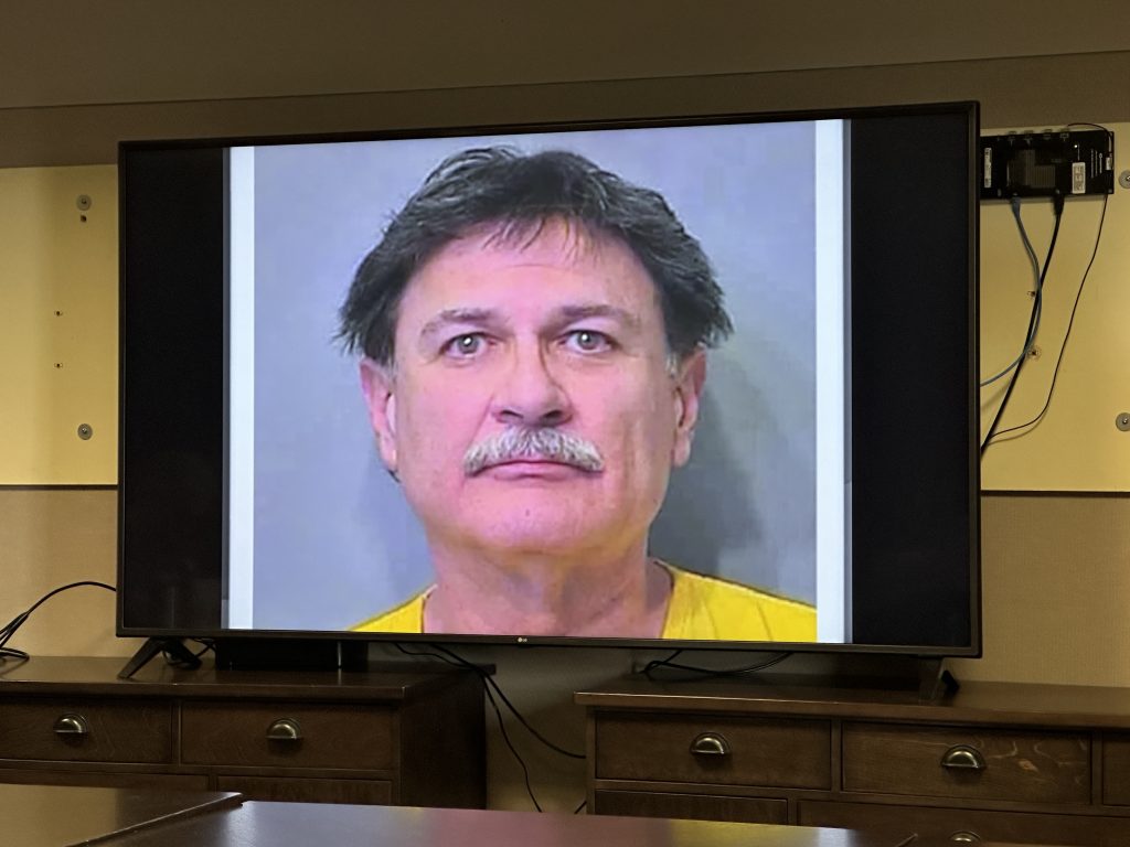
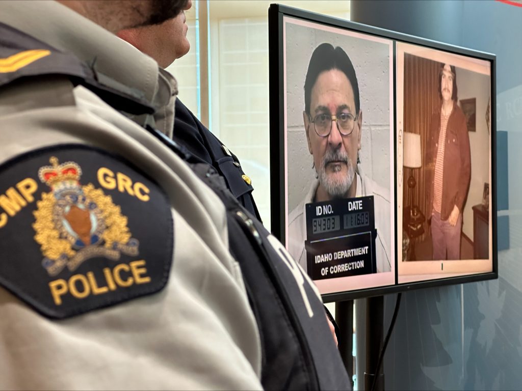
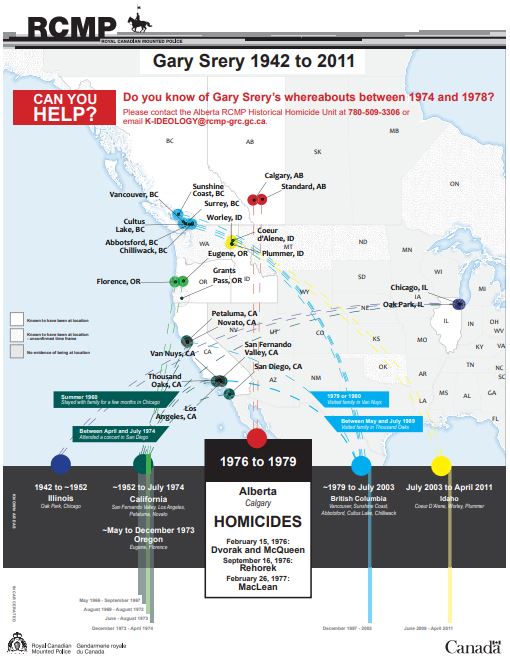
Alberta RCMP say Gary Allen Srery, who died in an Idaho prison in 2011, was a serial killer who was identified using advancements in DNA technology more than 45 years after the murders.
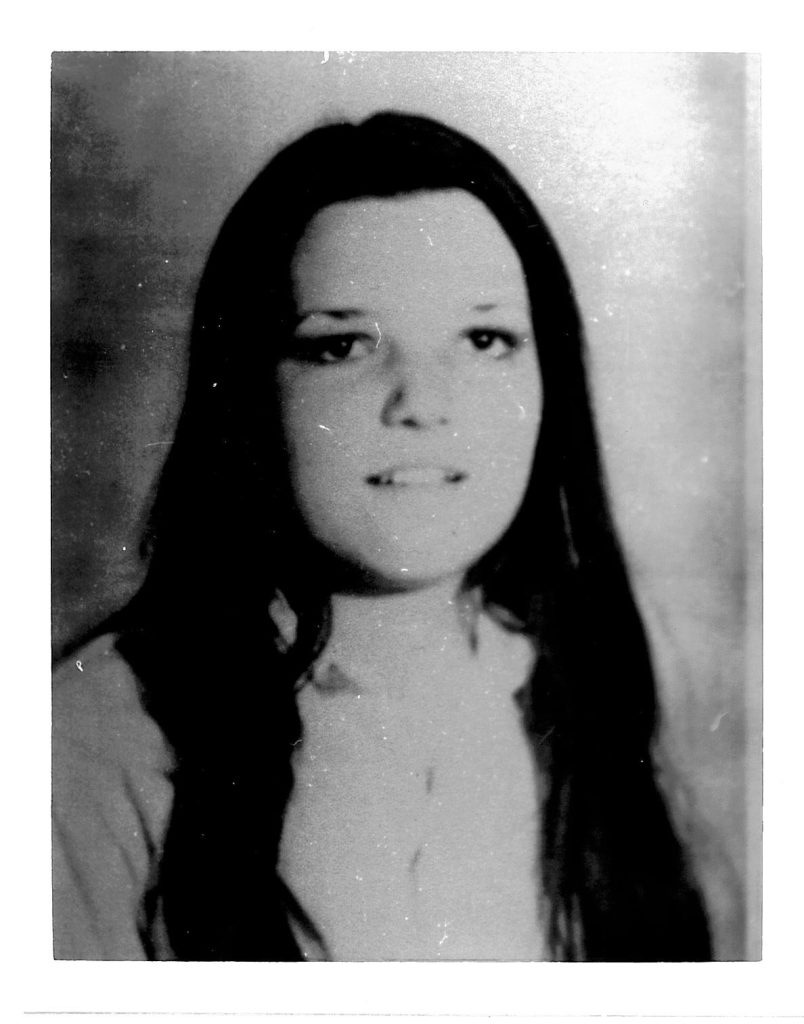
Police say the American killed Eva Dvorak and Patricia McQueen, both aged 14, Melissa Rehorek, 20, and 19-year-old Barbara MacLean in 1976-77.
Their murders went unsolved until a 2022 tip prompted a review of the historical files. That led police to a suspect hypothesis in 2023, and the creation of a family tree using DNA from distant family members on ancestry websites — a police technique known as investigative genetic genealogy.
READ MORE: Timeline of how police tracked down Calgary serial killer
The U.S.-born Srery, a serial sexual offender who fled to Canada in the mid-1970s, lived in Alberta and British Columbia until the late 1990s. He was deported to the U.S. in 2003.
Srery, who police say used multiple aliases over the years, was serving a life sentence for sexual assault when he died of natural causes in prison.
Police believe Srery could be responsible for several more homicides and rapes across Canada and the U.S. They are looking for more information about his whereabouts between 1974 and 1978, when his movements are less known to authorities.
Calgary police say they have looked into 114 unsolved homicides, but don’t believe Srery is linked to any of them.
Anyone with information can call the Alberta RCMP’s historical homicide unit at 780-509-3306 or email [email protected].
READ MORE: Victims’ families react after serial killer linked to historical Calgary murders
The four victims.
Alberta RCMP detailed the similarities between the four young women’s deaths at a Thursday news conference at K Division Headquarters in Edmonton.
Dvorak, McQueen, Rehorek and MacLean were all described as young, vulnerable victims who were last seen in Calgary and out walking during the evening or night. They all died of asphyxiation and were left outside city limits, with no attempts to conceal their remains. Their bodies were found fully clothed with traces of semen, which could not be identified at the time of the crimes because the proper technology did not exist to create a DNA profile.
Dvorak and McQueen were last seen on Feb. 15, 1976, around midnight, walking near 9 Avenue and 12Street SE. Their bodies were found 11 hours later on the road under the Happy Valley underpass, west of the city. Their deaths were initially classified as “sudden” and suspicious, but not homicides.

Rehorek, who had recently moved to Calgary from Windsor, was last seen by roommates at the YWCA downtown, where she lived, on Sept. 15, 1976. The young woman, who worked as a housekeeper at a hotel, had made plans to hitchhike out of town for her two days off work. Her body was found that morning at 10:50 a.m. in a ditch off a gravel road west of Calgary – what’s now known as Township Road 252. Police say there was evidence of a struggle and that she was punched in the head.
MacLean worked at a bank in Calgary after moving from Nova Scotia in September 1976. Five months later, on Feb. 25, 1977, she was last seen walking alone from the Highlander bar on 16th Avenue, where she had been out with friends. Her body was found just after 8 a.m. at 6 Street and 80 Avenue – just outside city limits. Police believe there was a struggle prior to her death as her left fingertips were injured, and she had marks, bruises and scrapes.

Police say the parents of all four victims have since passed away, but siblings and other living relatives have been updated.
Advancements in DNA technology
Alberta RCMP say police never stopped investigating the four deaths over the years. Four task forces were created in the 1990s, and technological advancements were applied in the 2000s. Police say a total of 853 suspects or persons of interests, and 1,490 vehicles were identified and investigated.
In 2003, DNA tests confirmed MacLean and Rehorek were killed by the same person. That DNA was tested again in 2006 and 2012 – comparing it to other suspects and through Interpol. There was no match.
In 2022, exhibits from Dvorak and McQueen’s deaths were resubmitted to the lab. The following year, police matched that DNA to the MacLean and Rehorek murders – linking all four women for the first time.
That led police to develop a DNA profile. The likely source, they determined, was Srery – a discovery that sparked a cross-border investigation.
Police outlined a life of crime for Srery from a young age.
He was convicted of rape and kidnapping in Los Angeles in the late 1960s before later fleeing to Canada. He lived in Calgary and Standard, Alta., from 1976 to 1978, with a brief return to California. Police say he managed to secure an illegal licence and social assistance while in Alberta.
He then moved to B.C. in 1979, where he was at one point employed by BC Ferries. He moved around a lot, from Vancouver (1979-80) to Half Moon Bay (1981-83), Gibsons (1983-88), Abbotsford (1988-90), Cultus Lake (1990-96), and Chilliwack (1996-98).
He was convicted of sexual assault in New Westminster, B.C., in 1996.
Alberta RCMP say Srery has used more than dozen aliases over the years such as Michael James Costello, David Blackwell, Willy (William) Blackman, Rex Edward Long, and Gary Delorme.
Top Stories

Residents in more than two-dozen inner city communities are without internet and phone service Tuesday following vandalism of a Rogers fibre line.

A robbery at Market Mall Monday has Calgary police on the lookout for three teenage boys.

Notorious serial killer Robert Pickton has been hospitalized with critical injuries after a vicious prison attack in Quebec.

OTTAWA — Canada’s annual inflation rate fell to 2.7 per cent in April amid a broad-based slowdown in price growth, boosting expectations of an interest rate cut next month. Statistics Canada said the...
Most Watched Today

CPS told City News, the teenagers were stealing items at a sports store in the mall and were caught in the act.

On Sunday, the West Hillhurst Community kicked off their community cleanup.

Over the long weekend, delegates had a chance to voice their concerns about the use of smartphones, as well as overcrowded class sizes.

The fate of Iranian President Ebrahim Raisi and Foreign Minister Hossein Amir-Abdollahian remains unknown after a helicopter carrying them reportedly crashed in the mountains near the Iran-Azerbaijan border. Karling Donoghue with more on the intense

Its the 40th season of downhill karting worldwide and Winsport has officially opened its downhill karting here in Calgary for the 2024 season.

Watch live on foxbaltimore.com as crews refloat the Dali container ship and bring it to port.
Baltimore City DOT announces traffic alerts for Preakness: Road closures and detours
by Lexi Harpster

BALTIMORE (WBFF) — The Baltimore City Department of Transportation announced traffic modifications that will be in effect for the 149th running of the Preakness Stakes, taking place on Saturday, May 18, 2024, at Pimlico Race Course.
ALSO READ | Plan on rain for Preakness in Baltimore
In preparation for the event, the following road closures and special traffic patterns will be implemented (times approximate):
Friday, May 17, 2024, starting at 5:00 a.m. until Sunday, May 19, 2024, at 1:00 a.m.
- Rogers Avenue – Closed from Winner Avenue to W. Northern Parkway
- Bland Avenue – Closed from W. Northern Parkway to Rogers Avenue
- Key Avenue – Closed from W. Northern Parkway to Rogers Avenue
- Woodcrest Avenue – Closed from W. Northern Parkway to Rogers Avenue
- Merville Avenue – Closed from W. Northern Parkway to Rogers Avenue
- Stuart Avenue – Closed from W. Northern Parkway to Rogers Avenue
- Rogers Avenue – One-way traffic westbound from Winner Avenue to Park Heights Avenue
- Winner Avenue – One-way traffic northbound from Hayward Avenue to W. Northern Parkway
Saturday, May 18, 2024, from 5:00 a.m. until 5:00 p.m.
- Westbound Northern Parkway – Right lane closure from Falls Road to W. Rogers Avenue
- Westbound Northern Parkway – Right lane closure from Greenspring Avenue to Pimlico Road
- Westbound Northern Parkway – Left lane closure from Preakness Way to Pimlico Road
- Eastbound Northern Parkway – Left lane closure from Park Heights Avenue to Greenspring Avenue
- Northbound Park Heights Avenue – Left lane closure at Hayward Avenue
- Southbound Park Heights Avenue – Left turn lane closure at Rogers Avenue
ALSO READ | Maryland Transit urges Preakness goers to take transit, offers shuttle service
Saturday, May 18, 2024, from 6:00 a.m. to Sunday, May 19, 2024, at 1:00 a.m. or until clear
- Southbound Jones Falls Expressway exit ramp to eastbound W. Northern Parkway will be closed. Motorists will be redirected to the Cold Spring Lane exits.
- Cylburn Avenue – Closed from W. Northern Parkway to Greenspring Avenue
Saturday, May 18, 2024, from 7:00 a.m. until 5:00 p.m.
- Hayward Avenue – One-way traffic eastbound from Park Heights Avenue to Winner Avenue
Saturday, May 18, 2024, from 5:00 p.m. to Sunday, May 19, 2024, at 1:00 a.m. or until clear
- The north & southbound Jones Falls Expressway exit ramps to westbound Northern Parkway will be closed. Motorists will be redirected to the Cold Spring Lane exits.
Saturday, May 18, 2024, from 5:00 p.m. until Sunday, May 19, 2024, at 1:00 a.m.
- Pimlico Road – Closed from W. Northern Parkway to Ken Oak Avenue
- Hayward Avenue – One-way traffic westbound from Winner Avenue to Park Heights Avenue
- Rogers Avenue – Closed from Pimlico Road to Greenspring Avenue
Saturday, May 18, 2024, from 7:00 p.m. to Sunday, May 19, 2024, at 1:00 a.m. or until clear:
- Eastbound Northern Parkway – Right lane closure from Key Avenue to Pimlico Road
The DOT advises that patrons attending Preakness festivities are strongly urged to carpool or use public transportation . Motorists that choose to drive to Pimlico Race Course should park at commercial lots and avoid parking in area neighborhoods. All posted parking restrictions will be strictly enforced, and vehicles parked in violation will be ticketed and towed. Vehicles that are relocated during the event will be taken to Cylburn Avenue just south of Northern Parkway. Motorists with questions concerning the location of their vehicle should call 311.
Motorists traveling in northwest Baltimore on Saturday, May 18th may experience delays throughout the day and are encouraged to download the Waze.com app for live detour navigation.
IMAGES
COMMENTS
Provides up to the minute traffic and transit information for Alberta. View the real time traffic map with travel times, traffic accident details, traffic cameras and other road conditions. Plan your trip and get the fastest route taking into account current traffic conditions.
Click the map for road and weather conditions. Tweets by @511Alberta. See the latest official road conditions, road restrictions, wide load reports and emergency alerts with 511 Alberta.
Get advisories and alerts. Sign up for advisories and alerts so you are informed when emergencies, disasters or unexpected situations occur in your area. On this page: Emergency alerts. Health advisories. 511 road reports. Alberta Parks advisories. Fire bans. Flood advisories.
Travel advisories. Visit 511.alberta.ca for up-to-date information on road closures and travel advisories. Emergency alerts. Alberta Emergency Alerts provide critical information about an immediate disaster, where it is occuring, and what action you need to take. Find active alerts.
Thunderstorm warning for parts of central Alberta. An Environment Canada thunderstorm warning is in effect for parts of central Alberta. Severe thunderstorms are capable of producing strong winds, hail and heavy rainfall. Be prepared to adjust your driving to changing road conditions. For details, visit Environment Canada . May 16 2024, 1:55 PM.
Travel Advisories inform the public about construction activities, road closures and other information which help them to make informed decisions when travelling on Alberta's highways. 2018. 2017. 2016. 2015. 2014. REVISED: Shaftesbury Ferry shuts down at the Highway 740 Crossing Flooding closes or threatens highways in Eckville, Rimbey areas
Traffic Speeds Road Conditions You can click on any road segment to view detailed information about road conditions. ... Weather Forecasts Weather Alerts Snowplows / Maintenance Vehicles Message Signs Border Crossings Rest Areas and Turnouts
Advisory: Hazardous Road Conditions - Alberta (Issued May 06, 2023 at 07:09 PM) Advisory: Hazardous Road Conditions - Alberta. ... Everyone must avoid all non-essential travel in all fire affected areas. Affected areas (1): Alberta; Action to take: No services will be available along affected routes;
Check the official interactive road conditions map with live traffic cameras from 511 Alberta. Alberta road conditions, road reports and traffic cams | 511 Alberta Alberta.ca
Camera List. Highway 1: 100m West of Alderson Gas Plant Road. Highway 2 North of TWP. Road 834. Highway 2 North of TWP. Road 780. Highway 3: 1.9 km East of Alberta BC. Border. Highway 3: 5.8 km East of Chin Road.
Road Reports. 2 New Alerts View All Alerts. Search for a City or Town. Road Conditions. Cameras. Traffic. Road Events. Construction. Weather.
Country Hills Boulevard. Crowchild Trail. Glenmore Trail. Heritage Drive. Highfield Road. John Laurie Blvd. Kensington Road. Lake Fraser Gate. Macleod Trail S.
A. 511 Alberta is a free traveller information service, operated by the Alberta government, that may be accessed via phone, mobile device or computer. The information covers highway conditions, roadwork, major incidents, weather alerts, availability of ferry services and waiting times at border crossings. Users within Alberta may access the ...
Speed limit in effect: 30 km/h. Additional Information: BF13587 Battle River Bridge on Highway 41, 18KM north of Wainwright, bridge repairs from July 23 until October 31, 2018. Expect one-lane alternating traffic with intermittent road closures of up to 10 minutes after 8pm daily. Speed reduced to 30km/h.
511 Alberta is an interactive, easy to use system allowing travellers to quickly access timely and reliable information on road conditions, traffic, roadwork activities and incidents on the provincial highways. 511 Alberta offers multiple ways to access information: Map View; Text Report
Call 911 from anywhere in Alberta to access fire, ambulance and police emergency services. The numbers below are best for non-emergency police services, such as lost or stolen property and minor accidents. 403-266-1234 in Calgary. 780-423-4567 in Edmonton. 780-788-4000 in Fort McMurray.
Forest area office contacts. Information line: 1-866-394-3473 (FYI-FIRE) Media inquiries: 780-420-1968. Email: [email protected]. Download the Alberta Wildfire app. Previous Report a wildfire. Next Get a fire permit. Find active wildfires on the wildfire dashboard, see wildfires of note and find the latest forest area updates.
10 to 20 min. Golden to Alberta Border. 157 min. 15 to 30 min. Cumulative Delays for Entire Route from Kamloops to Alberta Border. 402 min (6 hours 42 min) 50 to 90 min. Travellers on Highway 1 - Kamloops to Alberta often continue their travels on the following routes. There may be additional delays due to other construction projects.
This is in place to reduce traffic and avoid hindering emergency response efforts. Trusted sources of information: For the most up-to-date information on provincial fire advisories and restrictions, download the Alberta Wildfire App or visit albertafirebans.ca. If you see a fire in the forested area, report a wildfire, call 310-FIRE (3473).
Provides up to the minute traffic and transit information for Alberta. View the real time traffic map with travel times, traffic accident details, traffic cameras and other road conditions. Plan your trip and get the fastest route taking into account current traffic conditions.
Stay safe and save time by checking the latest road, ferry, border or weather conditions before you hit the road. Road conditions. British Columbia; Alberta; Saskatchewan; Washington State; Oregon State; Ferries and borders ... World Weather Forecasts; International travel advisories. Foreign Affairs and International Trade Canada; MEMBERSHIP
The cause of this wildfire remains under investigation. Firefighters continue to work on strengthening the containment line on MWF017, May 19, 2024. Jean Lake Complex (MXC001) is made up of two wildfires (HWF021 and MWF010), located near Birch Mountains. MWF010 is 7,976 hectares in size and HWF021 is 378 hectares.
A large fire about 10 miles southwest of Fort McMurray, in northeast Alberta - an area that was devastated by a wildfire in 2016 - had consumed over 23,000 acres as of Tuesday after growing ...
May 20, 2024. Within months of the Pearl Harbor bombing on Dec. 7, 1941, the United States, in cooperation with the Canadian authorities, set out to build a highway from British Columbia to Alaska ...
US-69 closed in Kansas City. The road is closed between I-70/US-40/Exit 420 and Ruby Avenue in Kansas City. The impacted road section is 1.24 miles long. The traffic alert was released Monday at 7 ...
On Saturday, May 18, 2024, the Lawyers Have Heart 5K, 10K, & Fun Run will take place in the District of Columbia. In conjunction with this event, there will be street closures that motorists should take into consideration: The following street will be closed by the Metropolitan Police Department to vehicle traffic from approximately 5:30 a.m. to 11:00 p.m.:
A convicted sexual offender with an extensive criminal history in Canada and the U.S. spanning several decades is responsible for the deaths of four young women in Calgary in the 1970s, according to police. Alberta RCMP say Gary Allen Srery, who died in an Idaho prison in 2011, was a serial killer who was identified using advancements in DNA ...
In preparation for the event, the following road closures and special traffic patterns will be implemented (times approximate): Friday, May 17, 2024, starting at 5:00 a.m. until Sunday, May 19 ...