Live & Book

Weather forecast
day after tomorrow
Lift tickets
Live panorama map, timetables & prices, mountain excursions, accommodation.
- Booking in only 3 minutes
- Maximum protection & excellent assistance
- Real guest reviews
- 97% customer satisfaction

Holiday flats

Tickets & Shop
Ski tickets, train tickets, accomodation, monday, 22. april 2024.
- Planning hikes & tours
Tour Monte Rosa - Matterhorn
- print version
- Share the current page on Twitter
- Share the current page on Facebook
- Share the current page on Google+
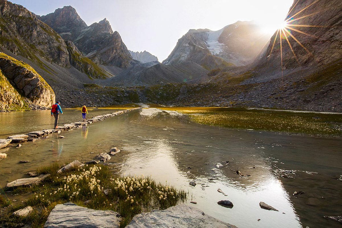
This tour around the Monte Rosa massif is one of the finest long-distance hikes in the Alps. Requirements: fitness and stamina.

- Type Multi-day hike
- Difficulty hard
- Duration 58,00 h
- Distance 164,1 km
- Ascent 10654 m
- Descent 10660 m
- Lowest point 1148 m
- Highest point 3316 m
Description
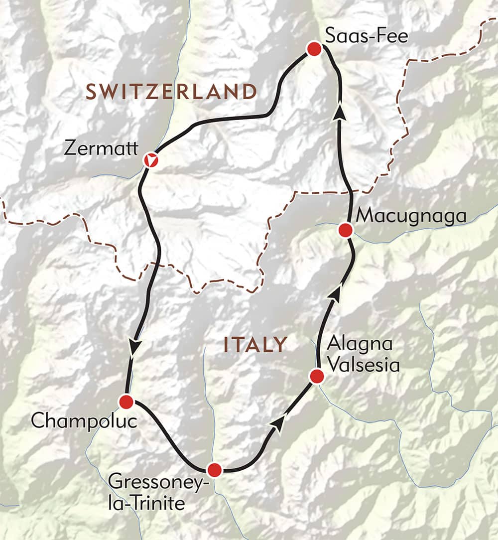
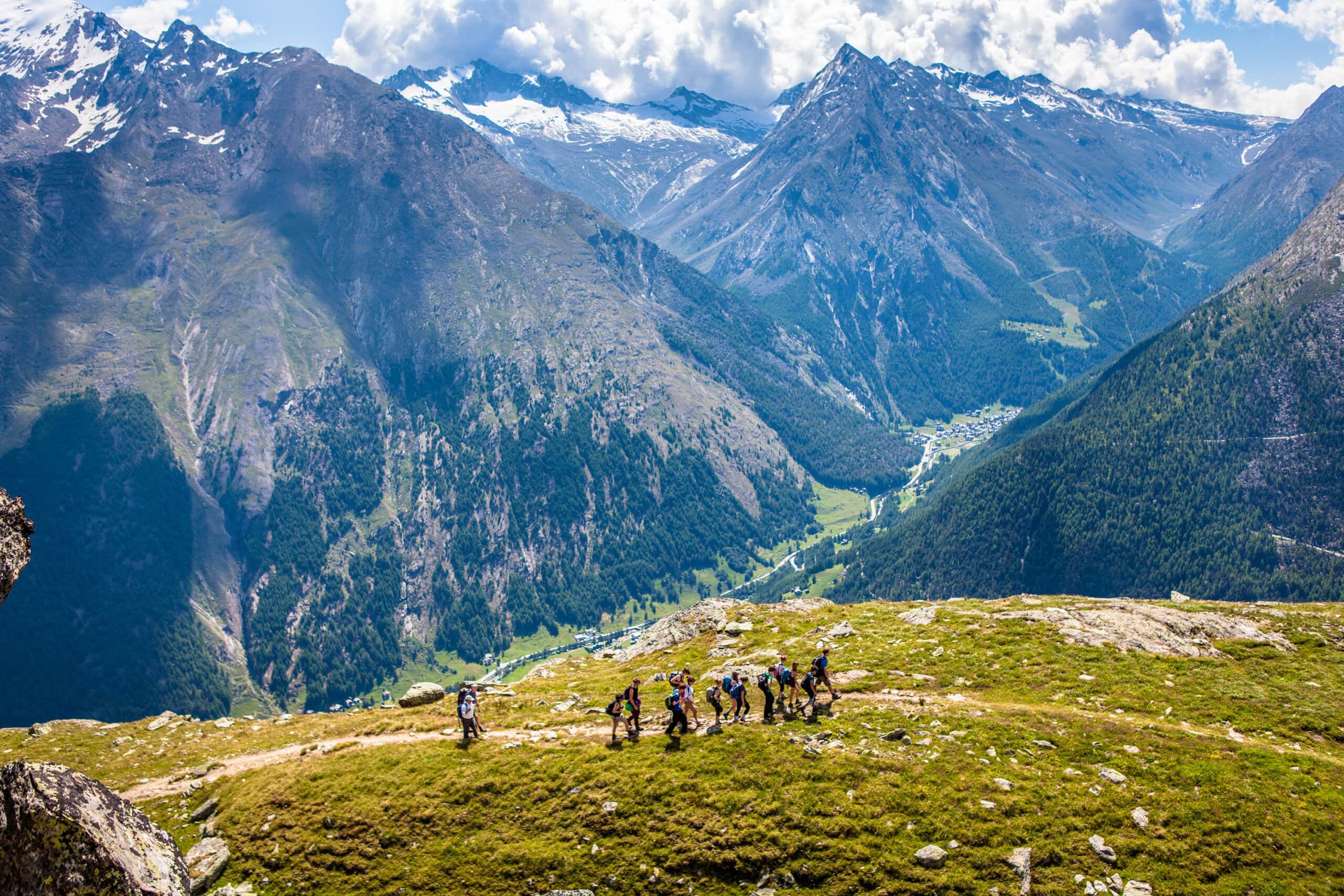
The view into the different valleys in Switzerland and Italy is unforgettable. Hikers see not only the highest and most beautiful mountains in the Alps, but also mountain villages with different cultures and of incomparable character. The stage destinations are well-known: Zermatt, over the Theodul Pass to Cervinia, Alagna, Macugnaga, and back into Switzerland via the Monte Moro Pass, to Saas-Fee and Grächen. The route leads anticlockwise around the Monte Rosa massif, an endlessly fascinating world of rock and ice. Hikers also make a complete circuit of the Mischabel peaks and the 4,000-metre summits of the Nadelgrat ridge. A thrilling adventure that is simply unforgettable!
- Tour card with certificate and annual competition
- High above the Matter valley: glorious views of the Matterhorn
1. Zermatt – Theodul Pass (5h 25) 2. Theodul Pass - St-Jacques (5h 30) 3. St-Jacques - Gressoney (4h 15) 4. Gressoney - Gabiet - Alagna (6h 20) 5. Alagna - Macugnaga (8h) 6. Macugnaga / Staffa - Saas-Fee (8h 55) 7. Saas-Fee - Grächen (6h 25) 8. Grächen – Europa Hut (7h 20) 9. Europa Hut - Zermatt (6h 10)
Note: A new ski slope is being built at the Theodul Pass this summer and a lot of construction activity is to be expected.
We recommend:
- Good, sturdy footwear
- Hiking poles (optional)
- Clothing suitable for the weather (always carry a waterproof)
- Food and water
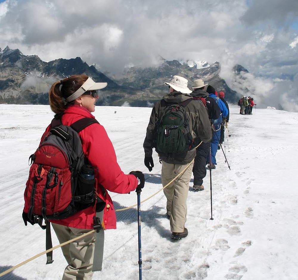
Additional equipment for glacier crossings: crampons, climbing harness, 1 rope per group of 4, suitable clothing
Reserve mountain huts and accommodation in mountain villages in advance.
The mountain landscape along the Tour Matterhorn is known for its breathtaking panoramas, attractive mountain villages and wealth of fauna and flora.
- Plan every mountain tour carefully and adapt to participants’ fitness level as well as the weather and season.
- Weather conditions can change quickly in the mountains. Appropriate clothing is therefore essential, along with adequate supplies of food and water. In uncertain weather, turn back in good time.
- Inform others of planned route, and whenever possible avoid going alone.
- Do not leave the marked routes; do not venture onto glaciers without a mountain guide.
- Please be considerate to other walkers and to plants and animals.
- Take note of the warning signs drawing attention to the constant danger in river beds and along watercourses below dams and reservoirs.
Important! This is a demanding alpine trek; stages may include glacier traverses. We therefore recommend the services of a mountain guide with local knowledge. Tip: “Be searchable”. Equip yourself with an additional RECCO rescue reflector*. Whether summer or winter. Available in our Online-Shop or our information desk. *The additional reflector does not replace an avalanche beacon.
Map and arrival

Experiences & activites

Gift Vouchers

AGM Zermatt Tourism: A magical financial year

Zermatt Tourism takes part in the biggest night in Hollywood

Grow beyond yourself with the Mammut Mountain School

Tips of the day

Room / Appartment 1
Room / Appartment 2
Room / Appartment 3
Room / Appartment 4
- Best Hikes In The World
- Appalachian Trail
- European Hikes
- Nepal Hikes
- Patagonia Hikes
- See All Hikes
- Mount Kenya
- Mount Kilimanjaro
- Mount Toubkal
- See All Mountains
- South Africa
- New Zealand
- Switzerland
- United Kingdom
- Packing Lists
Tour de Monte Rosa – A Classic Alps Hiking Route

Europe , Hikes , Italy , Switzerland

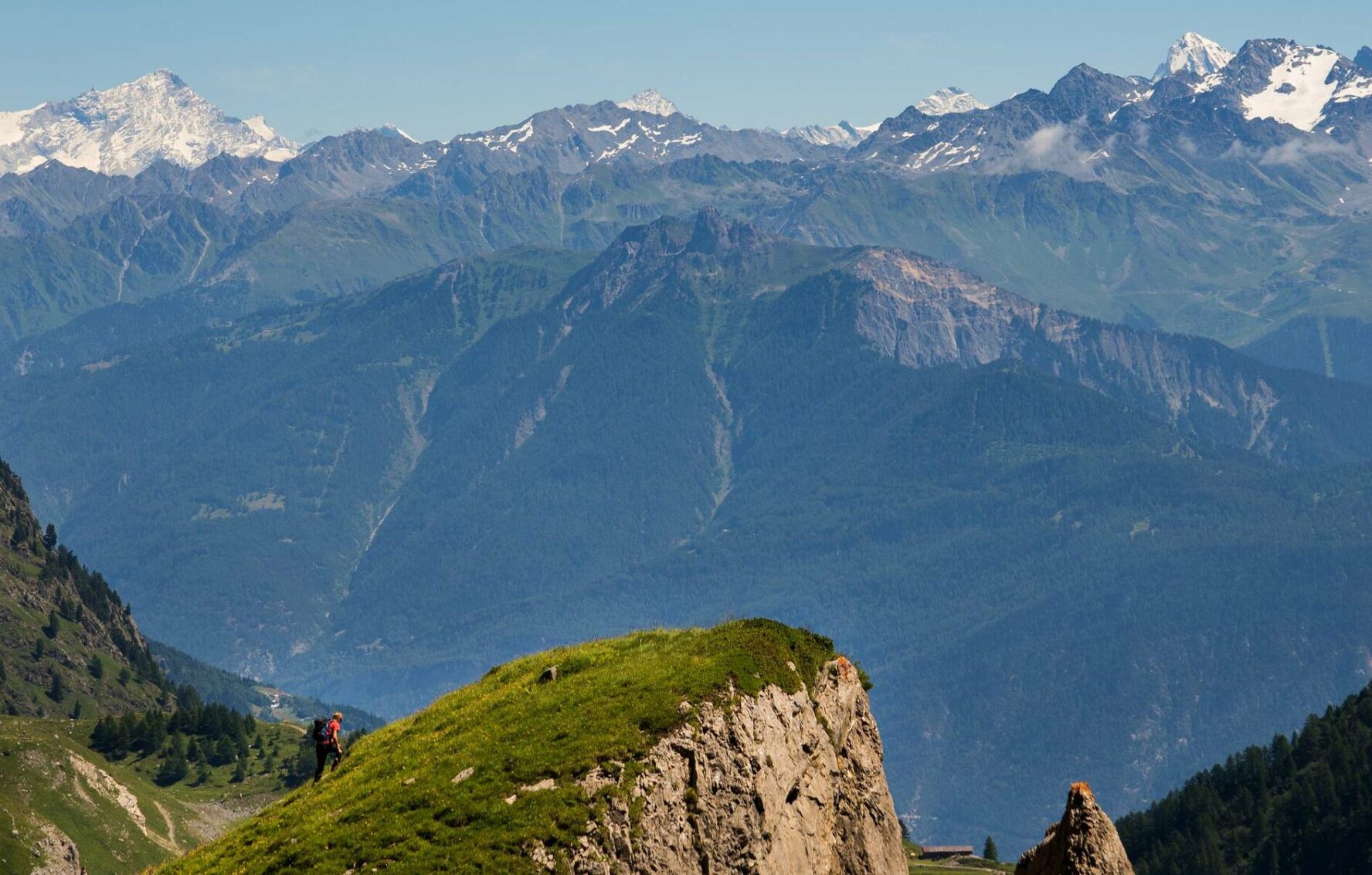
With ten peaks reaching higher than 4,000 meters, the Monte Rosa massif is one of the most impressive in the Alps . It is fair to say that the 9 day Tour de Monte Rosa trek, around the massif, is one of the best hiking routes in Europe .
The hike provides an epic mixture of awesome mountain-scapes across two great European states.
From hushed mountain passes to green valleys dotted with wooden Swiss Chalets during the first half of the hike, to the tranquility of remote Italian mountain villages during the latter stages of the trek, the Tour de Monte Rosa provides a great alternative to the Tour du Mont Blanc .
But do be aware, despite being one of the most scenic treks in the Alps, the route is strenuous , particularly the 3,295m high crossing of the Theodul Pass!
Join a Matterhorn Highlights Hike
Book with our recommended local guide
Tour de Monte Rosa Overview
The Tour de Monte Rosa is a long, multi-day hiking trail covering a total distance of 162 kilometers and gains more than 13,000 meters of altitude over 8 to 10 stages.
The highest point reached on the hike is 3,295 meters.
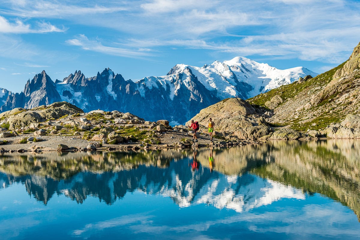
Most people start their hike in Täsh, Switzerland going in an anti-clockwise direction. Resting just to the east of the Matterhorn, the stunningly beautiful Monte Rosa is situated at the border between Switzerland and Italy .
The Tour de Monte Rosa provides a perfect opportunity to experience the different valleys in both countries.
On the circular hike you will pass some heavily glaciated areas, be afforded many scenic views of the highest peaks in Switzerland and take on some of the highest mountain passes in the Alps. The route will bring you to famous towns such as Zermatt, Aosta and Saas Fee, while crossing the notorious Europaweg.
You may also like : hiking in Switzerland
Tour de Monte Rosa Pros & Cons
Here's what we like and dislike about the Monte Rosa hike.
- Incredible views of the Monte Rosa massif and the Matterhorn
- Hike in two countries - Switzerland and Italy!
- Walk the amazing Europaweg between Grächen and Zermatt - this route is considered by many to be the most beautiful 2-day hike in the Alps
- Spend the night in some of the most famous European mountain huts
- More expensive than standard camping hikes due to the use of mountain huts
- Physically challenging, not for the faint-hearted
Monte Rosa Hike Route Map
This map illustrates the Tour de Monte Rosa.
Most people start their hike in Täsh or the Saas Fee.
The route is normally done in an anti-clockwise pattern but if you want to make the route a little easier then a clockwise plan is better as the ascents are more gradual.
You will need to cross Theodul Pass (3,295m), which is one of the highest passes in the Alps.
For an excellent guidebook and map we recommend Hilary Sharp's The Tour of Monte Rosa: A Trekker's Guide .
Monte Rosa Trail Altitude Profile
In the chart below you can see the altitude profile of the full hike. It is quite clear there is a lot of altitude to be gained over the stages. The heighest point is 3,295 meters. You can see that there are a few strenuous stages reaching high mountain passes that will require great effort.

This profile was produced by Trace de Trail and shows the altitude profile for the hike as well as the ultra marathon!
Tour de Monte Rosa Itinerary
Below we have laid out the most popular version of the Tour de Monte Rosa route – 9 days, starting and finishing in Saas Grund. The itinerary includes approx. distances, hiking times and elevation changes.
Day 1: Saas Grund – Macugnaga
Ascent: 650m Descent: 1500m Hiking time: 6-8hrs
The Monto Moro pass sitting at 2,853m is your first major col of the journey. Soon after you will reach the Italian part of the trip. Cameras will be much used since you will have great views of the Monte Rosa massif and an impressive look onto the Macugnaga wall.
Day 2: Macugnaga to the Rifugio Pastore
Ascent: 1450m Descent: 1300m Hiking time: 7-8hrs
A great route over the Colle del Turlo while you reach the valley of Alagna. The Monte Rosa will be out of view, but not for long.
Day 3: Alagna to Col d’Olen
Ascent: 1750m Descent: 560m Hiking time: 7-8hrs
A lot of altitude gain today, since you will need to reach Bocetta delle Pisse before descending to Alpe Pianlunga. You can spend the night at a rifugio close to lake Gabiet.
Day 4: Col d’Olen to Resy
Ascent: 1050m Descent: 1300m Hiking time: 6-8hrs
When you reach the Gressoney valley you will truly feel yourself in the Italian Alps. Enjoy an Italian coffee while admiring the impressive Monte Rosa. But don’t depart too late, since there still is an ascent to complete before reaching the refuge at Resy, which is a stunning location.
Day 5: Resy to the Matterhorn!
This is one of the highlights of the trek as you begin with a wonderful traverse towards the meadows of Alpe Varda and Alpe Mase. Soon you will gain views of the Breithorn while you’re climbing towards the Colle Superieur delle Cimes Blanches 2982m. From the top of the pass you gain first views of the Matterhorn, 4478m. After a short descent, your ascent continues to Theodul Pass at 3295m, where you spend the night.
Day 6: Theodul Pass – Zermatt
Descent: 1700m Hiking time: 5hrs
An easy day since all you need to do is descend. Your day starts with the crossing of the glacier before passing Gandegg and on towards the Mattertal.
Day 7: Zermatt to the Europahutte
Ascent: 850m Descent: 300m Hiking time: 6hrs
A pleasant start to the day since you head down the Mattertal before climbing steadily alongside the Europweg, a high mountain route. Be careful of rockfall, since this is unstable terrain. Spend the night in the Europa hut.
Day 8: Europahutte to Grachen
Ascent: 500m Descent: 850m Hiking time: 6-7hrs
Your hike along the Europaweg continues by crossing boulder fields with stunning views.
Day 9: Grachen to Saas Grund
Ascent: 1300m Descent: 1200m Hiking time: 6-7hrs
Even though it’s the last day of the Tour de Monte Rosa, you will finish in style, since this is one of the most stunning paths in the Alps.
Monte Rosa Hiking Video
A beautiful video overview of the Tour de Monte Rosa by valsesiaincoming1 .
Tour de Monte Rosa FAQ
When is the best time to trek the tour de monte rosa.
The best time to tackle this high-level trek around the Monte Rosa massif depends on the amount and timing of the previous winter’s snowfall and the onset of cold weather in the autumn.
Since the route crosses high passes (Theodul at 3295m), snow can create dangerous conditions. Therefore in a normal year it is not advisable to set out before early July .
In the summer months, July and August, the trail is busiest, temperatures can rise to 25 degrees, but thunderstorms or a dump of snow is possible as well.
By the end of September huts will close and it might get a lot harder to complete the trek.
How much does the Tour de Monte Rosa trek cost?
Guided trekking tours of the Tour de Monte Rosa will cost in the region of $1,500-$2,000.
This will include mountain hut accommodation, food throughout the trek and luggage transfers between each stage, which will allow you to enjoy the hike with just a small backpack. You will also be accompanied by an experienced guide.
The trek can however be done unsupported. The cost would be in the region of $1,000. A DIY trek would mean carrying more weight in your backpack and some planning of logistics in the weeks / months before.
How difficult is the Tour de Monte Rosa trek?
Hiking the Tour de Monte Rosa is strenuous and demanding. Make sure your are physically and mentally fit for the trek. There are many steep, uphill sections to conquer, with over 13,000m of altitiude gained throughout the circuit. You need to ensure you are in shape for the physical demands of this route. Mental fitness is as important and often go hand in hand.
The Tour de Monte Rosa is doable for any fit mountain walkers who are able to hike between 5h and 8 hrs per day for several days in a row.
Please note : there are a few sections where you can use public transport to shorten your hike if you are struggling.
Are permits needed for the Monte Rosa trek?
No permits are required to the Monte Rosa circuit trek.
Is altitude sickness a risk on the Monte Rosa trek?
No, you will not cross passes any higher than 3,300 meter, and since you’re hiking slowly to this altitude, you have more than sufficient time to acclimatize.
Most people don’t feel any symptoms of altitude sickness before reaching 3000-3500 meter. But this is when they haven’t spent enough time acclimatizing.
What gear do I need for the Monte Rosa?
To do a serious hike like the Tour de Monte Rosa you will need appropriate layered clothing, including a warm insulated jacket and a hard shell waterproof layer .
Some comfortable lightweight trekking boots are a must to enjoy this trek, while good waterproofs are essential, not only to protect you against rain or snowfall but to double as windproofs. Since you’ll be crossing passes of more than 3000 meters, gloves and several base / second layers may prove useful. Trekking poles are a good way to not overload your knees and ankles.
If you are hiking unsupported you will need to carry a 50-60L backpack , however, if you plan to join an organised tour then many organisations will often include luggage transfer to your next accommodation in the valley, so you only need to carry a small backpack with some lunch, snacks and clothes.
A good three season, preferably four season sleeping bag is a must!
To help you plan and prepare for your trek we recommend reading our gear section .
Browse more hikes in Europe
See our top European hikes picks, or check out these popular hikes.
- Tour du Mont Blanc
- Walkers Haute Route
- Camino de Santiago Routes
- Cinque Terre Hiking
- West Highland Way Hike
- El Caminito del Rey
- Laugavegur Trail
- Kungsleden Trail
- Rota Vicentina
- Slovenian Mountain Trail
About the author
Mark Whitman
Mark has trekked extensively in Asia, Europe, South America and Africa. He founded Mountain IQ in 2014 with the sole aim to be the best online information portal to some of the most popular mountain destinations around the world. When not writing for Mountain IQ, Mark is out exploring the outdoors with his wife!
Leave a Reply
Your email address will not be published. Required fields are marked
I am wondering if there is a possibility of shortening the trip and what your recommendation would be to do such.
I remember I ended the trek at Staffal (Gressoney-La-Trinité) and traveled with public transport to Milan. I liked the part crossing Theodulpass so my advice would be to follow the route clock-wise towards Zermatt. This would take 3-4 days, so you could hike further along the Europaweg towards Sint Niklaus as well, adding two extra days.
If you have mountaineering aspirations or just want some bragging rights 😉 you can climb Breithorn along the way from Klein Matterhorn. This is an easy 4000 meter peak, which requires crampons and ice axe though, but only takes 3 hours. It gives you awesome views on Matterhorn and Monte Rosa massif.
Hi. Great site. Thanks for offering help. If I fly in to Milan and have 6 hiking days, what are suggested routes? [Beginning August. Dad & Grad (son graduating high school). Fitness – I run marathons, he runs half marathons. We had a great 4 day hut to hut experience in Switz/ Bernese Oberland a few yrs ago.] I assume we can’t do full circuit. Is that right? Thank you!
HI Tagrey, see our answer to Michael Wirth below. Cheers!
Hello! Thanks for the info above. I’m planning on self guided walk in July. I’ve done a lot of hiking but new to the alps. Is saas-fee – Macugnaga a fairly manageable 30km first day? Seems too short to stop at Britannia Hutte after only 10km.
Thanks! Bella
Hi Bella, thanks for getting in touch. I’m not 100% sure as the person who wrote this guide has left Mountain IQ. I recommend checking out this website for self-guided help: https://www.thehiking.club/
We work with local guides to offer great value adventures at unbeatable prices
- Zermatt - Theodulpass Closed
- Theodulpass - St. Jaques Closed
- St. Jaques - Gressoney Closed
- Gressoney - Alagna Closed
- Alagna - Macugnaga Closed
- Macugnaga - Saas Fee Closed
- Saas Fee - Grächen Closed
- Grächen - Europahütte Closed
- Europahütte - Zermatt Closed
- Points of Interest (POI)
- Zermatt - Theodulpass
- Theodulpass - St. Jaques
- St. Jaques - Gressoney/Gabiet
- Gressoney/Gabiet - Alagna
- Alagna - Macugnaga
- Macugnaga/Staffa - Saas Fee
- Saas Fee - Grächen
- Grächen - Europahütte
- Europahütte - Zermatt
- accommodations
- links and phone numbers
- litterature
- advertising
Latest News
The Tour Monte Rosa is closed.
Due to the constant changes of condition on the Theodul Pass, we recommend booking a mountain guide: Tip: - Zermatters (Mountain guides from Zermatt) - Guide del Cervino (Mountain guides from Cervinia)
Gressoney - Alagna: Diversion in the Moos area via 7b until the end of August.
The Tour Monte Rosa is open.
The Monte Moro Pass and the route from Saas Fee to Grächen are closed.
The Monte Rosa tour is open. On the Monte Moro Pass and on the Theodul Pass there may still be some snow in places, otherwise the tour is passable throughout.
Europaweg and suspension bridge closed. From Thursday 04 Nov 2021, the suspension bridge in Randa will be closed. The bridge may NOT be crossed in winter and will open again in spring. We do not accept any liability.
The Europaweg trail is closed. The circular hike from Randa to the suspension bridge remains open until further notice.
The tour is open.
July 16, 2021
Despite the bad weather during this week, the work on the Europaweg could be completed. The opening will take place tomorrow, July 17, 2021.
All information on the new path can be found at www.europaweg.ch .
July 11, 2021
Snow on the following passes: Col de Nannaz, Passo Foric!
Attention: The detour is not marked.
The section Europahütte – Zermatt is open.
The circular hike from Randa to the suspension bridge is open. The Europaweg trail is closed.
The planned trail construction work between Grächen and the Europahütte will begin in spring 2021. The new trail is expected to be open to hikers in August 2021. Until the completion of the construction work on the new Europaweg, the existing provisional route will remain active.
The Grächner Höhenweg is currently closed. The reason is a debris flow near the Eistbach. The path will probably not open this year. The Monte-Moro pass is snow-covered.
Due to rockfall, the section of the Europaweg «Flüewald – Taflüe – Herbriggen» stays closed. Please be aware of the detour via Mattsand and the signage.
Due to rockfall, the Europaweg is impaired on the Grächen - Europahütte section. Please inform yourself about the current situation on site. The Europahütte and the circular route to the suspension bridge can still be reached from Herbriggen.
All paths of the Tour Monte Rosa are officially passable throughout. There may still be snow on the passes.
The stage from Grächen to the Europahütte will be open again on Saturday, 08 June 2020. Hikers have to pay attention to the new route (see pdf below).
Welcome hikers!
Navigate to myswitzerland.com
Destinations
Your swiss holiday time.
Holiday destinations
- Summer holiday destinations
- Winter sports & ski resorts
- Family destinations
Attractions
- Top attractions
- UNESCO World Heritage sites / biospheres
- Travel by train, bus or boat
- Top museums
- Swiss Parks
- Scenic nature
Experiences
Additional content about subnavigation experiences.
- Family excursions
- Food & Wine
- Group excursions
- Guided tours
Summer & Autumn
- Bicycle & Mountain bike
- Adventure & Sports Summer
- Zoo & animal experiences
- Ski and snowboard
- Cross-country skiing
- Snowshoe and winter hiking
- Tobogganing
- Winter excursions
- Christmas in Switzerland
Cities & culture
- Parks, Gardens and Squares
- Architecture
Experience Tour
- Car, motorcycle - Grand Tour
- Train, bus, boat – Grand Train Tour
- Mountain excursions
Accommodation
- Typically Swiss Hotels
- Wellness & Spa
- Family Hotels
- Bike Hotels
- Boutique Hotels
- Inspiring Meeting Hotels
- Swiss Historic Hotels
- Luxury hotels
- Winter sports hotels
Other types of accommodation
- On the farm
- Bed and Breakfast
- Mountains huts
- Group accommodation
Transport & Stay
- Travel to Switzerland
- Barrier-free travel
- Tickets public transport
- Service & support
- Money and shopping
About Switzerland
- General facts
- Custom and tradition
- History of Switzerland
- The Swiss Art and Culture Scene
- Health Travel
- Sustainability
Weather & Climate
- Climate in Switzerland
- Snow Report
- Water and pool temperatures
- City offers
- Touring offers
- Wellness offers
- Nature and outdoor offers
- Offers for families
Where are you from?
- België (Nederlands)
- Belgique (Français)
- Deutschland
- Netherlands
- Russia (Россия)
- Schweiz (Deutsch)
- Suisse (Français)
- Svizzera (Italiano)
- Switzerland (English)
- United Kingdom
- Canada (English)
- Canada (Français)
- China 中文简体
- China 中文繁体
- Gulf countries العربية
- Japan 日本
- Korea 한국어
- United Arab Emirates
- New Zealand
- International

Language, region and important links
- Slovenština
Service Navigation
- Help & Contact
Swiss Tour Monte Rosa

- Distance 56 km
- Ascent 4000 m
Powerful combination: the Balfrin high-level trail from Sass-Fee to Grächen and the Europaweg trail from Grächen to Zermatt form the «Swiss Tour Monte Rosa». Three-day panoramic hike with stunning views of the icy 4000-m mountains of Saastal and Mattertal.
Description
«You stand at the end of the world and at the same time at its origin, at its beginning and at its centre. A phenomenal silver setting, of a complete semi-circle, to the south snow-capped summits arranged in inexplicable harmony, to the west a chain of Gothic cathedral towers. At first you can only look up at them in awe, it’s breathtaking». No one describes the Saas-Fee Alpine backdrop as impressively as German author Carl Zuckmayer, who spent his last years in the glacier village. Thirteen 4000-metre peaks standing as guards of honour; can there be a more striking start to the «Swiss Tour Monte Rosa»?
This is a sensational panoramic tour, starting on the first day with the Balfrin high-level trail. It links Saas-Fee with Grächen and is a real challenge even for fit mountain hikers. The trail then leads from Grächen to Zermatt with spectacular views. Sections secured by ropes, waterfalls and bridges provide the trail with the necessary spice – and that with views of mighty 4000-m mountains including the «Mountain of Mountains», the Matterhorn.
The Swiss Tour Monte Rosa is identical to the «King’s Stage» of the classical Tour Monte Rosa (TMR), an eight-day trekking tour around the Monte Rosa massif.

Content provider
An enjoyable tour includes the careful planning of the same. Please inform yourself in advance at the local information center about the route and weather conditions. Depending on the season and weather conditions, this route may be blocked or interrupted
Technical information
Swiss tour monte rosa, stage 1/3, swiss tour monte rosa, stage 2/3, swiss tour monte rosa, stage 3/3, quick facts, route number.
Advertisement
A Legendary Hike through the Swiss and Italian Alps
Tour de monte rosa.
Italy, Switzerland
From $7,695
Call 1-800-368-2794 or contact us for any questions
Arrive: Zermatt, Switzerland
Depart: Zermatt, Switzerland
- Cross high passes and glacial terrain, explore mountain hamlets of character, stay in alpine hotels
- Savor breathtaking, less-traveled trails away from the crowds, crossing through the Aosta and Saas Fee valleys
- Enjoy mid-hike lunch stops in historic alpine huts perched in incredible spots
- Hike the legendary TMR trail encircling Monte Rosa on a spectacular route through the Italian and Swiss Alps
- Begin and end in Zermatt, the delightful village right below the Matterhorn
Dates & Pricing
Pricing below is per person and based on double occupancy. The earlier you book, the more choice you’ll have. WT also has the most generous cancellation and transfer policies in the industry, we make it easy if you change your mind. Have a small group of your own? Take over an existing date or choose your own. You’ll have your own private guide–and the adventure–all to yourselves!
Payment & Cancel Schedule
$600 due at time of reservation 90 days prior to departure: Balance
Cancellation & Transfer Schedule
Up to 91 days prior to departure: No Charge! 61-90 days prior to departure: 25% of trip cost 46-60 days prior to departure: 50% of trip cost 45 days or less: 100% of trip cost
- Expert leadership of at least two Wilderness Travel Trip Leaders
- Accommodations in hotels and mountain inns
- All meals included except 2 dinners as indicated in Detailed Itinerary
- A glass of wine or beer with dinner
- All ground transportation and baggage handling from meeting until departure
- All activities as indicated in Detailed Itinerary
- Cable cars, funiculars, and cog rails to and from trailheads for scheduled hikes
Not Included
- Travel to and from the arrival and departure location as indicated in Detailed Itinerary
- Additional hotel nights outside the trip's scheduled dates
- Optional gratuities to Trip Leaders or staff
- Optional travel insurance
- Other expenses of a personal nature (some alcoholic beverages, laundry, etc.)
Accommodations
Scroll through our signature accommodations for this trip below. Although it is highly unlikely, we may make substitutions when necessary.
BEAUSiTE Zermatt
Zermatt, Switzerland
Days 1-2 (2 nights)
Hotel Castor
Champoluc, Italy
Day 3 (1 night)
Hotel Lo Scoiattolo: Gressoney-la-Trinité
Gressoney-la-Trinite, Italy
Days 4-5 (2 nights)
Alagna Resort
Alagna Valsesia, Italy
Day 6 (1 night)
Dream Hotel
Macugnaga, Italy
Day 7 (1 night)
Walliserhof Grand-Hotel & Spa
Saas-Fee, Switzerland
Days 8-9 (2 nights)
Day 10 (1 night)
What the Trip is Like
- 3,000 feet gain/loss
- Altitudes range 7,000 to 10,000 feet
- Day 7 & 8: both roughly 12 miles, 8 hours, 4,000 feet gain, and 4,500 loss
Other Trips You Might Like
Small Group Adventure
Mont Blanc to the Mediterranean
From $7,395
Tour du Mont Blanc
France, Italy, Switzerland
From $5,795
Ultimate Dolomites
From $6,995
Ultimate Haute Route
France, Switzerland
Book your trip today
Our Area Specialists know every detail about our tours. They will be happy to answer any questions and help you choose the journey that’s right for you. Contact us to learn more or book your trip today!
Submit the form below to download itinerary
Trip Download Itin
Trip Levels
With more than 200 different adventures to choose from, we want to help you find the trip that’s right for you. Our Trip Level system ranks each trip in two ways: a number rating from 1 to 6 according to the activity, and general travel rigors. 1 is the easiest and 6+ the most difficult—see descriptions below for explanations of each number. A plus (+) sign means the trip is a bit more strenuous than other trips of that level. The detailed explanation of each trip—below the bar with the number rating—is perhaps more important, specifying activities, altitudes, hiking, and travel conditions. The Detailed Itinerary, available by download or mail, gives further information. Our Area Managers can also answer questions and guide you to the trip that best suits your interests.
Level 1 – Easiest
Non-camping journeys, optional walks, little elevation gain or loss.
- Royal Rajasthan and Villages of India
- Small ship cruises
Level 2 – Easy to Moderate
Hotel nights and/or safari-style camping, hikes of two to four hours on some days. Other physical activities are sometimes included, such as optional sea kayaking.
- Our African safaris
- Costa Rica Wildlife
Level 3 – Moderate
Half- to full-day hikes (3-6 hours) over rolling countryside on most days, occasional steep trails. Many of our hotel-based walking tours are in this category, as are our snorkeling adventures.
- Tuscany & the Cinque Terre
- Argentina: Hikes and Estancias of Patagonia
- Palau Snorkeling & Sea Kayaking
- Some trips with minimal hiking but rugged travel conditions or long drives, such as Tribal Ghana, Togo & Benin, are Trip Level 3.
Level 4 – Moderate to Strenuous
Full-day hikes (4-6 hours), mountainous terrain, significant elevation gains and losses (hiking up or down as much as 3,000 feet) on many days. Altitudes no greater than about 10,000 feet.
- Ultimate Patagonia
- Hiking the Spanish Pyrenees
Level 5 – Strenuous
Full-day hikes (4-8 hours), mountainous, steep terrain (hiking up or down as much as 3,500 feet) on many days. Trips with hiking at average altitudes of 10,000 to 12,000 feet are in this category.
- Inca Trail to Machu Picchu
- Everest Lodge to Lodge
Level 6 – Very Strenuous
Full-day hikes (5-8 hours), mountainous, steep terrain (hiking up or down as much as 3,500 feet) on many days. Most hikes take place at altitudes above 10,000 feet, with some days ascending as high as 18,000 feet.
- Everest Base Camp
- Climb Kilimanjaro!
Hiking Tour of Monte Rosa
July-August
Ticino (Switzerland) and Aosta Valley (Italy)
A spellbinding, circular hiking tour, in Switzerland and Italy , around the second highest mountain in Western Europe. Monte Rosa , a giant massif comprising, and surrounded by, most of the 4,000-meter peaks of the Alps , is shared by Switzerland and Italy , namely the canton of Valais and the regions of Aosta Valley and Piedmont. Spectacular valleys radiate from its snow-covered flanks, each one dominated by magnificent scenery. Among them, the Zermatt Valley and Saas-Fee valley, glaciated heavens in Swiss territory, and Valle Anzasca in Piedmont .
The Highest Mountain in Switzerland
One of its summits, Dufourspitze (4634m/15431 ft.), is Switzerland’s highest peak , and second highest in Western Europe, after Mont Blanc . Monte Rosa’s 2000 m/6000-foot east face is the highest rock face in the Alps, and it confers upon this elegant giant the title of “only mountain of Himalayan proportions.”
Between Switzerland and Italy
This part of the Alps has some of the most magnificent hikes in the world, and The Tour of Monte Rosa is one of the greatest opportunities to appreciate fully a truly humbling, mountainous environment. Alpine trails and historic paths lead us deep into the canton of Valais in Switzerland , and the Piedmont Valle d’Aosta regions in Italy , introducing us to a fascinating history and a multitude of cultures, traditions, and architectural styles. The cuisine is as varied, as well, reflecting the typical gastronomy of each area visited.
A Path of Rock and Ice
Starting in Saas-Fee, we journey around this regal mountain, enjoying sublime landscapes and panoramas. We conclude our efforts with an easy descent on the Theodul Glacier , in the company of a licensed alpine guide, before we enjoy a deserved rest in Zermatt , at the presence of the legendary Matterhorn .
You may also be interested in these other tours

Puglia – Mystical Land
Hiking in Cinque Terre and Portofino

Piedmont’s Wine Country
The alps’ mail.
Just insert your e-mail address below to sign up for our newsletter. You will receive updates on our tours and valuable information on our destinations.
Previous Project Walking and Hiking in Ticino
Next project wildflowers of the bernese oberland.
© 2024 Alps and Beyond. © Copyright 2018: Alps and Beyond di Anna Bezzola | Bellinzona, Switzerland | [email protected] | Privacy Policy
- Swiss tours
- Italian Tours
- Custom Activities
Hiking the Tour de Monte Rosa
Learn about the historic roots of the Tour de Monte Rosa hiking route, a gorgeous and wild loop from Zermatt through Italy around Switzerland’s tallest mountain.

Multi-Country hut-to-hut hiking on the Tour de Monte Rosa
Walking the Tour de Monte Rosa (TMR) route through Italy and Switzerland, an unfolding gallery of panoramic mountains, quaint villages, and idyllic streams greets your eager eyes. Perfectly set stone trails seem to exist just for the enjoyment of hikers. It might be hard to imagine walking along this sweeping path with an enormous load of salt and spices on your back. But, in fact, that is exactly the use these “roads” were originally built to serve.

A Brief History of the Hiking Route
The Monte Moro Pass was once a local trade and seasonal migration route for the Walser people, some of the region’s most influential inhabitants. Walser refers to people from the upper Valais region (or Wallis in German) who had a long history of migrating to uninhabited areas, building new communities, and spreading their language, culture and lifestyle to many areas in the Alps. You’ll notice the Germanic flavor to settlements even on the Italian side of mountains. The trail over Monte Moro was forged as a mule trail for traders crossing between these 2 valleys.
Today, the Madonna delle Nevi (Madonna of the Snow) watches over the pass. She was placed in 1966 and is a popular destination for many local Catholics during the feast days in early August. This small area is popular for both skiing and hiking, with local lifts from Macugnaga that make access easy. Its proximity to the Italian Lakes District also makes it a popular destination for Italians looking to exchange big city hustle for the ease of smaller mountain villages.

Further west, the Theodul Pass linking Italy’s Aosta Valley and Switzerland’s Valais Canton historically served as a bridge for resources, religion, and politics. Sometimes it even meant survival when the strain on resources grew with populations in both areas. The pass remains a formidable obstacle for those traveling across the border between Zermatt and Cervinia, with a crossing of the Theodul glacier still necessary. But crossing the Theodul will soon be much easier. A new cableway connecting the Matterhorn Glacier Paradise station and the Testa Grigia station above Cervinia is in the works. Skiing has replaced the trading of goods. But the pass still remains an important link between the people and economies of the region.

Hiking the Tour de Monte Rosa Today
The convenience of modern travel makes access to the Alps fairly straightforward. The trails surrounding the Monte Rosa massif still serve as the most direct path of travel between the remote valleys you’ll visit here. Trading may be done a little differently now, but these paths are still well-used. For hundreds of years, they have held up extremely well and are still traveled much like they were back then: on foot.
Are you looking to explore this route? Check out our Private Guided Tour of Monte Rosa .
- Switzerland ,
Sign up for our newsletter!
Add your contact info below so we can stay in touch with you!
- Name * First
- Phone This field is for validation purposes and should be left unchanged.

- Privacy Overview
- Strictly Necessary Cookies
This website uses cookies so that we can provide you with the best user experience possible. Cookie information is stored in your browser and performs functions such as recognising you when you return to our website and helping our team to understand which sections of the website you find most interesting and useful.
Strictly Necessary Cookie should be enabled at all times so that we can save your preferences for cookie settings.
If you disable this cookie, we will not be able to save your preferences. This means that every time you visit this website you will need to enable or disable cookies again.
Tour de Monte Rosa Hiking Adventure
June through September
Geneva, Switzerland is less than 3 hours away
11 days (9 days of trekking)
Things to know
There are very few hiking feats in the Alps that could beat crossing the Tour de Monte Rosa. Shared by Switzerland and Italy, this trail encircles one of the most impressive massifs in the Alps, named after the highest peak of both countries: Monte Rosa. Crossing its 100 miles, you will enter a collage of lofty peaks dominating cow-speckled villages and sleep soundly in rustic refuges beneath glaciers. Walk the centuries-old roads taking you to knee-trembling mountain passes before crossing suspension bridges spanning Alpine lakes and forested valleys. After 9 days of trekking and 42,000 feet gained in altitude, finish right where you started—and learn why the Tour de Monte Rosa is considered one of the best hiking routes in the Alps.
Cross a trail that circumnavigates ten +13,000-foot peaks
Experience the world-famous Matterhorn, Zermatt, and Euroweg
Stay in authentic mountain huts immersed in sublime Alpine scenery
Join your guide for 11 days of Alpine bliss in Switzerland and Italy! Cross one of the most demanding—and the most epic—hiking circuits in the Alps: Tour de Monte Rosa. Enjoy incredible scenery with 10 peaks above 13,000 feet, hike in glaciated terrain and stay in rustic refuges and charming hotels in quaint villages and towns, including Zermatt. Relish great food, breathe in some mountain air, challenge your body and recharge your mind—the Monte Rosa massif awaits you open-armed.
Your trip starts in the village of Saas Grund, a walking distance from the well-known ski resort of Saas Fee. Meet your Tour de Monte Rosa hiking guide in the village or in your accommodation in the afternoon, do a gear check, and meet your fellow hikers over dinner. Meals : Dinner

Day 2 starts with a short bus ride to Mattmark, where your group will start gently, following the side of Lake Mattmark. This is a good warm before tackling the first col of your Tour de Monte Rosa hiking trip—the Monte Moro, which stands at 9,360 feet (2,853 m). Enjoy the stunning views of the Weissmies (13,200 ft / 4,023 m) and the Rimpfischhorn (13,773 ft / 4,198 m) peaks. On arrival at the pass, your group will be greeted by Monte Rosa itself. After a steep descent through boulder fields, you arrive in the village of Macugnaga, where you will stay for the night. Meals: Breakfast and dinner Hiking: 15 km (9.32 miles) Altitude gain/loss : +750 m (2,460 ft) / -1,600 m (5,250 ft)

Day 3 features one of the longest climbs of the trek. Start your hiking by following the torrent of Anza towards the lake at Quarazza. Afterward, you will climb steadily through the spruce forests to Alpe Plana, with views of impressive waterfalls behind you. Pass over the Colle del Turlo and enjoy the views of the Weissmies peak once again. From here, your group will have a long steady descent to your overnight stop at the Rifugio Pastore. Meals: Breakfast and dinner Hiking: 23 km (14 miles) Altitude gain/loss : +1,510 m (4,955 ft) / -1,300 m (4,265 ft)

From the refuge, your hiking on the fourth day starts with a climb to the Vallon delle Pisse. The route follows the waterfall underneath the glacier of the Piramide VIincent, one of the smaller peaks of the Monte Rosa Massif. After passing the cable car station at Alpe la Balma, take on a steep and rugged path over the Bocchetta delle Pisse, followed by a descent to Alpe Pianlunga. Another winding ascent takes your group through the Valle d’Olen, then back down to the refuge at Lake Gabiet, your accommodation for the night. Meals: Breakfast and dinner Hiking: 15 km (9.32 miles) Altitude gain/loss : +1,800 m (5,905 ft) / -650 m (2,135 ft)

Your hiking starts more gently today. You will first cross the Colle d’Olen, then descend through the larch forests to the Rifugio del Lys. From here a nice trail through forests and meadows brings your group into Gressoney Stafal. From here, head up to Alpe Sitten, and take a path to the only pass of the day—the Colle di Bettaforca. You will then take an easy trail down to the pretty hamlet of Resy, spending the night high above the Ayas Valley. Meals: Breakfast and dinner Hiking: 16 km (10 miles) Altitude gain/loss : +970 m (3,180 ft) / -1,200 m (3,935 ft)

Day 6 begins with a short descent towards the meadows of Alpe Varda and Alpe Mase—one of the highlights of the trek. Climb steadily to the Colle Superieur delle Cime Blanche (2,982 m / 9,783 ft), with the Breithorn above us. From this vantage point, enjoy your first unforgettable views of the Matterhorn (14,692 ft / 4,478 m). After descending through the glacial moraine, tackle a steep final climb to the highest point of the trip, and your base for the night—at the Colle del Teodulo (10,883 ft / 3,317 m). Meals: Breakfast and dinner Hiking: 18 km (11 miles) Altitude gain/loss : +1,550 m (5,085 ft) / -300 m (985 ft)

Today your group will be joined by an IFMGA qualified guide, as you descend the Theodule glacier (the spelling has changed now since you are back in the German-speaking area!). The group will be roped up, but no other specialist equipment is needed, other than your hiking boots and trekking poles. Enjoy the views of the Matterhorn and other peaks: the Alphubel, Dom, Obergabelhorn, Zinalrothorn, and Weisshorn. At Gandegg, leave the ice of the glacier behind, and descend to the famous mountaineering town of Zermatt—situated beneath Matterhorn. Meals: Breakfast and dinner Hiking: 16 km (10 miles) Altitude gain/loss : +460 m (1,510 ft) / -2,070 m (6,970 ft)

Leaving Zermatt, follow the Mattertal towards the Rhone Valley and stroll through meadows and larch forests. After Täsch, enter the village of Randa, and start a steady climb on a steep zig-zag trail. You will pass under the rugged peaks of the Täschorn and the Dom, before reaching your base for the night: Europahütte, a relatively new hut in a stunning location. The alternative route of getting from Zermartt to Europahütte is along Europaweg, arguably the most scenic two-day hiking trail in the Alps—featuring the longest pedestrian bridge in the world. Meals: Breakfast and dinner Hiking: 16 km (10 miles) Altitude gain/loss : +890 m (2,920 ft) / -300 m (985 ft)

Today your traverse continues across boulder fields, with rugged cliffs towering above, and the Breithorn and Matterhorn behind us. Enjoy stunning views as your group tackles the cables and bridges on this exciting trail. The Riedgletscher lies in our path, so we descend steeply and drop down through the woods to our overnight stop at the village of Grächen. Meals: Breakfast and dinner Hiking: 17 km (10.6 miles) Altitude gain/loss : +600 m (1,970 ft) / -1,180 m (3,870 ft)

On the final day of the tour, you will take the Hohenweg path to Hannigalp, high above the Saastal. This stunning path is a little lower and greener than those covered in the previous days, but still with exposed sections that demand your full attention. Directly ahead, you can enjoy the views of the snow-topped Weissmies, and the Lagginhorn. The Tour de Monte Rosa guided trek comes to an end as your group arrives back where you started: Saas Grund. Take some well-earned rest and celebrate your achievements with your guide and fellow hikers. Meals: Breakfast and dinner Hiking: 21 km (13 miles) Altitude gain/loss : +1,220 m (4,000 ft) / -1,270 m (4,165 ft)

Your tour finishes after a hearty breakfast. Say goodbye to your guide and fellow hikers and go back to the airport—or continue touring on your own. Meals: Breakfast

Meet your guides

I’ve been on seven treks in the Alps, including Chamonix-Zermatt, the TMB, and the Bernese Oberland. I’ve also managed to climb seven of the easiest peaks. The trip that I have enjoyed the most was the 2016 Tour de Monte Rosa led by Emma Jack. The weather and varied scenery were superb (except for day two which was wet and misty). The group was eclectic but friendly and the length and difficulty of the tour just right for me. The accommodation (five nights in hotels and five in refuges) was of a very good standard and was fabulous at the Rifugio Gabiet and at the Hotel Hannigalp in Grachen.
What you get on this adventure:
- An experienced, local hiking guide with extensive knowledge of the area
- Qualified IFMGA guide for the glacier section
- 11-day hiking adventure along the Tour de Monte Rosa (9 days of hiking)
- Accommodation in hotels and mountain refuges
- Meals as indicated in the itinerary
- Transportation from Saas Grund to Lake Mattmark
What’s not included:
- Transportation to and from Saas Grund
- Airport transfers — we recommend Mountain Drop-Offs
- Lunches, drinks, and snacks
- Guide gratuities — optional
- Travel insurance — compulsory (covering medical expenses, mountain rescue including helicopter evacuation, and cancellation)
To join this Tour de Monte Rosa hiking trip, you need to be in excellent physical shape. You need to have a lot of hiking experience in mountain terrain and experience of multi-day treks. Be prepared for 9 consecutive daily hikes with 15 miles (23 km) of distance covered on the longest day. Daily altitude gains will be between 1,510 and 5,900 feet (460-1,800 m). What makes Tour de Monte Rosa different from similar Alpine treks is an obligatory glacier crossing. Keep in mind that you will be followed by a special guide for this section. On regular days, you will take many breaks and will also always be followed by an expert hiking guide who will make sure you are comfortable on the trails.
Here’s a list of the equipment you need to bring:
- Day pack large enough to carry all the items listed (around a 25-40L bag)
- Hiking poles — optional
- Water bottle or hydration bladder (2L capacity)
- Lightweight hiking boots or shoes
- Spare clothes for layering
- Waterproof rain jacket
- Waterproof pants
- Base layers (top and bottom)
- Mid layer—usually a fleece
- Hiking pants (shorts as well if you want)
- Toiletries (sunscreen, hand sanitizer, bug spray, etc.)
- Headlamp or flashlight
- Camera — optional (but recommended)
Dress comfortably and for the weather in clothes you can move in. We suggest bringing clothing appropriate for the season. Layers are best and don’t wear jeans.
During your guided Tour de Monta Rosa trip, you’ll be staying 5 nights at mountain refuges and 5 nights at local hotels. When it comes to hotels, you’ll be staying in private rooms. Mountain refuges, however, have shared rooms and dormitories. Although some of them are quite rustic, the view of the surrounding mountains and their authentic charm makes up for any lack of luxury. Nights spent in mountain refuges might just end up being the highlight of the trip due to unparalleled views and local wildlife. Because of the remote nature of the refuges, there won’t be any luggage delivery during the trip.
Group sizes and prices:
- For this group adventure, the maximum client-to-guide ratio is 10:1.
- It takes a minimum of 4 people for this tour to operate.
- The cost does not decrease as the group grows.
Trekking along the Tour de Monte Rosa can be arranged for larger groups. Contact us to make arrangements.
Min. age requirements:
- If you are older than 18, you’re good to go.
To get to Saas Grund, your starting point, most people fly into Geneva International Airport (GVA) , one hour away. Once you arrive, there are several ways to reach your destination, including public transport.
You will meet your guide at a predetermined location in the village or in your accommodation on day 1.
57hours is committed to providing safe outdoor adventure experiences. We require all guides using our platform to have a COVID-19 safety plan and to make the details of that plan accessible to travelers. In most cases, group sizes will be reduced, guides will avoid overcrowded locations, and other safety measures will be met depending on the location and activity.
We also expect clients to respect local regulations and take measures to protect themselves, guides and the communities they’re traveling to. For more information on COVID-19 measures in the Monte Rosa areas in Switzerland and Italy please refer to Switzerland’s official COVID-19 travel guidelines and Official Italian Tourism Website .
Please contact us if you have any questions or require further information. We are happy to provide you with the most up-to-date information!
A 30% non-refundable deposit to secure your place is due upon booking. The remaining amount is paid 10 weeks (70 days) prior to departure. Once the trip is confirmed by the guide, the cancellation policy stated below applies.
- If Client cancels the Booking anytime prior to seventy (70) calendar days in advance of the trip contemplated by the booking, only the Client’s deposit will be forfeited.
- For cancellations thirty-one (31) to seventy (70) calendar days in advance, Client is entitled to a refund in the amount of fifty percent (50%) of the total price of the trip.
- For cancellations thirty or less days in advance, Client is not entitled to any refund.
- Any reimbursable expenses arising out of the Booking incurred by Guide prior to the date of cancellation (including but not limited to plane tickets, car rental payments, and lodging or transportation fees) are non-refundable as soon as they are incurred by the Guide.
Secure your spot for 2025 with a 10% deposit! This tour gets sold out very quickly, but with early-bird booking, you can rest assured you’ve booked your dream adventure in time.
- Only 10% of the total amount should be paid as a deposit upon booking. This deposit is non-refundable, but can be transferred to another 57hours adventure anytime in case the dates don’t suit you. This can be done by the end of the year.
- Another 20% needs to be paid by the end of this year.
- The remaining balance is due 10 weeks (70 days) prior to departure.
Other things to do in Swiss Alps

Summer Hiking in Switzerland: Via Alpina Tour

Women’s Luxury Hiking Tour of Via Alpina, Switzerland

Hiking in Bernese Oberland of the Swiss Alps

Hiking in the Heart of the Swiss Alps for 50+ Women

Authentic Alpine Hiking: Four Springs Trek in Switzerland

Hiking Tour des Combins: The Secret Alpine Route
View all (19) adventures in Switzerland
Choose a currency
- USD - $ US Dollar
- EUR - € Euro
- AUD - AU$ Australian Dollar
- CAD - CA$ Canadian Dollar
- GBP - £ British Pound Sterling
- CHF - CHF Swiss Franc
- JPY - ¥ Japanese Yen
- SGD - S$ Singapore Dollar
- HKD - HK$ Hong Kong Dollar
- DKK - Dkr Danish Krone
- NOK - Nkr Norwegian Krone
- SEK - Skr Swedish Krona
- Route planner
Tour of Monte Rosa – a trek among the Giants between Italy and Switzerland
The Tour del Monte Rosa (TMR) is a 160-kilometre (99 mi) 10–stage trek that takes you among the highest peaks in Europe where the air is thinner, rocks tower above ice and silence is precious. This route is a mix of high mountains and moments of civilisation: some stages end at alpine refuges and others in characteristic villages on the valley floor. The experience is all encompassing: you experience every facet of the life of those who live at the foot of the Giants of Europe and the Walser culture. The landscapes are unbelievably beautiful, with 40 peaks over 4,000 metres (13,120 ft). Monte Rosa is your host on this adventure, but you also enjoy breathtaking views of the Matterhorn. The TMR is an old route. In fact, Horace Bénédict de Saussure, a wealthy Swiss scientist and a great mountaineer was the first to hike it in 1789. On 15th July, he set off from Geneva, crossed the Simplon Pass and entered this unknown land. The 19th century was a great period of discovery for 4,000-metre peaks, but I’ll tell your more about that on the way. Back then, the glacier conditions were very different to today. Equipment was basic and the pioneers of mountaineering often had no idea what they were getting themselves into. They made their approach in carts, on mules or with a bicycle – as far as they could go before their own legs were the only means of transport. Imagine a wild mountain, where the only noise was made by the breaking of ice and the crunching of snow under studded boots. Horace Bénédict de Saussure didn’t go into the mountains to enjoy a relaxed holiday as we do today. He went accompanied by his son to study the orography, indigenous populations and all the unique phenomena that characterise the mountains. Until his trips, the areas and peaks were unnamed or named by the communities that lived on them. Many areas were considered to be inaccessible or even demonic. As mentioned earlier, many followed in his footsteps and explored further in the 19th century. In the next century, however, this Tour was mostly forgotten, in part due to the outbreak of two world wars. In 1994, the Tour Monte Rosa Association was founded, continuing and improving upon the region’s long mountaineering history. This itinerary is cross–border between Italy and Switzerland, so remember that you’ll need two currencies. The best time to walk it is from June to September, i.e. when the alpine refuges are open. It’s very important to book your overnight stays well in advance, especially those in high-altitude refuges, as they’re often used by mountaineers conquering the high peaks. The Monte Rosa Tour is very demanding and requires plenty of physical preparation and alpine experience. You can simplify and shorten the route by using ski lifts. To take on this route, you also need to be comfortable with heights as some sections are exposed, although there are fixed ropes. There is also a long Tibetan bridge suspended across a drop on the Europaweg. You should always carry appropriate clothing for different altitudes, sun cream, sturdy boots, a first aid kit, plenty of water and energy bars. In case of an accident or emergency, call 112 in Italy or Switzerland. You can reach Staffa, the main town of Macugnaga, by car or bus from Domodossola station. The latter is connected to Milan by direct trains. Happy hiking among the Giants!
Do it yourself
Ready to get going? Create and customize your own version of this adventure using the full Tour below as a template.
Tour del Monte Rosa (TMR)
Last updated: April 18, 2024
Plan your own version of this adventure in the multi-day planner based on the stages suggested in this Collection.
Stage 1: Macugnaga to the Rifugio Oberto – Tour of Monte Rosa
The Monte Rosa Tour starts from Staffa, the capital of Macugnaga. This municipality, like many others scattered in the Italian Alpine valleys, can be said to be a widespread municipality, since there is no real center that bears the name of Macugnaga, but a set of small villages.
Stage 2: Rifugio Oberto to Saas–Fee – Tour of Monte Rosa
The east face of Monte Rosa gives you a good morning. Just think, that with its 2,600 meters in altitude it is the highest in the Alps. As I mentioned in the introduction, the peaks you see were explored and conquered in the nineteenth century. Already at the end of the eighteenth century some scientist … read more
by Marika Abbà
Sign Up To Discover Places Like This
Get recommendations on the best single tracks, peaks, & plenty of other exciting outdoor places.
Stage 3: Saas–Fee to Grächen – Tour of Monte Rosa
Leave the enchanting Saas-Fee behind and enter the Ussere Wald forest. The path leads you to a mountain pasture and from here it climbs up among larch and stone pines. Stop for a second and close your eyes. Breathe in. Let the scent released by the conifers inebriate your nostrils and let the symphony … read more
Stage 4: Grächen to Europahütte – Tour of Monte Rosa
An easy path takes you across the Grächen plateau allowing you to enjoy the alpine architecture typical of these places down to the last metre.
The path now takes you before Gasenried, at the foot of the Grathorn.
From here the route would follow a stretch of the Europaweg, a two-day loop that connects … read more
Stage 5: Europahütte to Zermatt – Tour of Monte Rosa
Say goodbye to the Europahütte and go down to the "Charles Kuonen" suspension bridge. This structure was inaugurated in 2017, is 490 meters long and is the longest Tibetan bridge in Switzerland. It was placed in this area because the old path was often battered by landslides and subsidence.
The route … read more
Stage 6: Zermatt to the Teodulo Hut – Tour of Monte Rosa
Today's stage will be emblematic, you will get to the heart of the Monte Rosa Tour and you will feel like you are touching the imposing peaks of the massif with a finger. Backpack and off we go!
Take the mule track that leads to the small Walser hamlets of Zermatt. Here the architecture perfectly reflects … read more
Stage 7: Teodulo hut to the Guide di Frachey hut – Tour of Monte Rosa
Leave the wonderful Teodulo refuge and descend towards the Cime Bianche lakes. The mule track you are traveling on was for centuries plowed by the Walser populations intent on colonizing the areas of the Gressoney and Ayas valleys. These places exude history and you will notice it more and more as you … read more
Stage 8: Guide di Frachey hut to the Gabiet hut – Tour of Monte Rosa
You leave from the Guide di Frachey Refuge and cross the numerous pastures that follow one another up to Alpe la Mandria.
Shortly after the Alpe, at the foot of Mont Cavallo, there is a lovely basin, Lake Ciarcierio. On clear days the surrounding glaciers are reflected in its waters. Here you can take … read more
Stage 9: Gabiet hut to the Pastore hut – Tour of Monte Rosa
After leaving the Gabiet refuge, proceed towards Col d’Olen. The path takes you through numerous pastures used in the past by the inhabitants of the Walser villages.
Just below the hill there are still traces of old gold mines owned by the wealthy family of Nicola Vincent, the first to touch the tip of … read more
Stage 10: Pastore Refuge to Macugnaga – Tour of Monte Rosa
Here you are at the last stage of this demanding Monte Rosa Tour. Today you will return to Macugnaga, but do not be saddened because beautiful surprises await you along the way.
Legs on your shoulders and take the ancient mule track on which the Walser population of Macugnaga traveled to colonize the … read more
Like this Collection?
Questions and comments, collection stats.
- Distance 102 mi
- Duration 70:08 h
- Elevation 32,700 ft 32,775 ft
You Might Also Like
Hiking the Tour of Monte Rosa
A 100-mile walk around a huge mountain that straddles the borders of Italy and Switzerland, this Alpine trail deserves to be better known, says Alex Roddie
This article was first published in TGO Magazine , July 2016
There’s something beguiling about Monte Rosa. The name sounds graceful, but the mountain is not – it’s a complex behemoth of glacier and rock straddling the Swiss/Italian border, and one of the highest peaks in the Alps at 4,634m. I’ve long been fascinated by this mountain. Years earlier, when climbing Castor or Pollux, I’d looked up at the impossibly bright snowfields and longed to be one of those ant-like figures crawling towards the summit.
Over in France, the famous Tour du Mont Blanc is a backpacking trail encircling the Mont Blanc massif. When I heard of a similar 100-mile route offering a 360° tour of Monte Rosa, I knew this was the trail for me.
I thought I had a pretty good idea of what to expect when I started my hike one sunny morning from Zermatt, but I soon discovered that the Tour of Monte Rosa is full of surprises.
The first came in the form of a big, scary sign warning of rockfall on the trail. The Europaweg, a high-level path from Zermatt to Grächen, has a gnarly reputation – but I just shrugged and asked myself ‘how bad can it be?’. The views down through unspoiled forests of larch and pine to the valley far below were stupendous, and every few minutes I’d turn around to gape in awe at the Matterhorn’s pinnacle thrusting up through the clouds and dominating the scenery in every direction. But after Täschalp things became more dicey. The weather closed in, and I found myself climbing ever higher into a wasteland of boulders and shattered gullies where nothing grew. The trail was exposed to stonefall for long stretches and it was unnerving to hear rocks crash and tumble through the mists, sometimes out of sight, sometimes shockingly close to hand.

Then came the next surprise: a diversion to avoid a wrecked bridge across a gully. 750m back down, almost to the valley floor, then steeply back up again to the Europa Hut at 2,265m. I was quickly learning that a key feature of the TMR is its relentless gradient profile.
The Europaweg Hut was full, so I pressed on in the hope of reaching Grächen before dark. But my progress slowed as the trail became even sketchier underfoot. I found myself benighted and looking for somewhere flat to camp, eventually choosing marginal perch on the edge of another gully that rumbled and rattled with landslides all night.

I enjoyed myself a little more after completing the Europaweg. The small town of Grächen is set amongst some of the most beautiful alpine forest I have ever seen. Golden eagles swooped overhead and called to each other on the warm summer breeze, and a passing hiker even claimed to have seen a lynx. Soon I’d turned the great prow of the Mischabel – one of Monte Rosa’s enormous satellite chains – and was hiking south along the Balfrin Höhenweg.
That’s when I started to see ibex. I spotted the first leaping expertly from rock to rock down the side of a cliff, but an hour later I was treated to the spectacle of two bucks battling it out only a short distance away. The clash of their horns echoed through the forest. It was a special moment. Traffic buzzed along the road a thousand metres below, and nothing moved in the sterile world of ice and rock above; but here, surrounded by the colours of late summer, everything felt just right.

Ups and downs
So far, Monte Rosa itself had been conspicuously invisible. I’d hiked deeper into Switzerland, then back towards Italy; soon I’d cross the border. When would I finally catch a glimpse of the mountain this trail was supposed to be all about?
The Monte Moro Pass, an ancient trade route between Switzerland and Italy, proved to be the key. The Monte Moro Pass reaches 2,853m and is the hiker’s first taste of being amongst the bigger mountains. Early in the summer there’s a good chance snow might lie on the route, but it’s never especially steep and is a popular hike. On the day I crossed, I stepped on snow only once and was so preoccupied with the view back along the Saastal that I hardly noticed the new vista unfolding in front of me – until, that is, I reached the top, and the tremendous East Face of Monte Rosa was visible in all its splendour.
This must surely be one of the best moments of any alpine backpacking route. The East Face is like a Himalayan wall plucked from its homeland and dumped in the middle of Europe. All around, the slopes of lower mountains rise from deep valleys, passing through shades of emerald green before merging to the slate greys of the summits. But Monte Rosa burned with that white-hot intensity I remembered – a jagged monster of a mountain, all complex cirques and hard angles but not without beauty.
And that’s where the trail changed. For the next sixty miles I had col after col to cross, in a relentless game of up and down that had my knees screaming for mercy. I’d studied the map beforehand so had a good idea what to expect, but the reality of climbing and descending up to 2,000m every day was absolutely exhausting – even though the scenery was worth the effort, most of the time.

The TMR became a little less defined in Italy. Suddenly I was faced with choices. Go left down the valley and climb this col, or go right and climb that one? It was a balancing act between total ascent and quality of scenery, and I didn’t always get it right. The Colle del Turlo, following ancient Roman pathways out of the forests of the Vallee Quarazza, was a wonderful section and I enjoyed every moment. But after dropping down to the village of Alagna Valsesia, I started climbing up to the Col d’Olen and got lost in overgrown and abandoned farmland without a path to be seen. ‘Maybe I should have bought the guidebook after all,’ I muttered after losing the path for the fiftieth time.
The pinnacle
I’d been looking for a suitable target for a fly-by peak-bagging mission on my way back towards Switzerland. My map presented plenty of options, but most either required technical mountaineering equipment or were insignificant-looking bumps on satellite ridges. I wanted something better.
One option stood out. Testa Grigia, a 3,315m mountain standing between Val de Gressoney and Val d’Ayas, is said to command unrivalled views of the entire Monte Rosa chain. There’s even a Club Alpino Italiano (CAI) bivouac cabin near the top. The official Tour of Monte Rosa passes to the north, over the lower and easier Comba de Fourcare, but I decided the diversion would be worth it.

A monster day of over 2,200m of ascent saw me climb from the other side of the Col d’Olen down to Gressoney, then back up to the Colle Pinter before making a final loose climb to the Lateltin bivouac hut at 3,132m in the dark. I was exhausted, and it had begun to snow outside, but the cabin had everything I needed: a stove, warm bedding, even food supplies. I settled down for the night and set my alarm for an early start.
I woke at dawn. Ice and a dusting of fresh snow glazed the rocks, and I wondered if the climb would be feasible without winter gear. But when I stepped outside the cabin and witnessed one of the most stunning temperature inversions I’d ever seen, I knew it had to be worth a shot. Cloud boiled a thousand metres below me, and shafts of sunlight cut through the mists to paint delicate pastel colours on the upper slopes of the mountain.

Even with a little black ice here and there, the scrambly ascent was safe in my trail shoes and the early morning sun melted off the snow soon enough. When I reached the summit at 3,315m, the vista over the Monte Rosa chain was everything I had hoped it would be: a grandstand view of one of the highest and best mountain massifs in the Alps, seen at the best time of day and from the best angle. Every summit stood proud and clear against the bluest of skies. Glaciers tumbled in chaos from the snowfields where they formed to the moraine where they melted and metamorphosed into rivers. It was a complete picture of mountain beauty, and the high point of my Tour of Monte Rosa experience.
Tip-toeing back to Switzerland
It wasn’t exactly all downhill after the ascent of Testa Grigia, but I’d broken the back of it. One final pass to go; one final chance to climb up into the mountains before the long descent to Zermatt.
The Theodul Pass is the highest point on the official TMR at 3,295m, and the only place where you have to set foot on a glacier. Until you get to the Cervinia ski complex, the walk up to the glaciated col is a delight: scenic paths through semi-managed woodland, followed by grassed-over ancient moraine that strongly reminded me of the Scottish Highlands. I took my time wandering through this mountain playground before finally camping beside the blue waters of the Grand Lac at 2,806m.
I’d been worrying about the glacier crossing. There’s only a short section of ice before a romp down the ski piste, but I’d heard conflicting reports about how steep the top section might be. Unwilling to carry ice axe and crampons over a hundred miles of hard trail just for one short glacier crossing, I hadn’t packed winter gear.

A freezing wind was blasting over the col as I stepped from rock onto hard-packed ice. The surface hadn’t melted as I’d hoped, and I prodded at it with the tips of my poles to gain purchase. Some other hikers were also about to make the short descent to the ski piste and we chatted about our adventures as they got out their ice axes. ‘We’re just returning from the Tour of the Matterhorn,’ they told me. ‘This is the first time we could have done with having crampons!’ Like me, they had chosen to save weight rather than pack spikes.
We zig-zagged down the glazed surface in single file, kicking and clawing with the edges of our shoes to get some bite, leaning on both poles for support. I would have been happier with some Microspikes – or just a slushy surface to allow me to kick steps – but in a few minutes we were off the slope and onto the well-groomed surface of the piste where the walking was easy.

The views on the walk back down to Zermatt were superb. Beyond the peak of the Riffelhorn, at the head of a distant glacier, lay Monte Rosa once again. I’d now seen this iconic massif from every angle, come to appreciate its different moods. But the variety of Monte Rosa extends far beyond its contrasting faces. Every valley I had crossed on my journey could trace the source of its rivers to the ice of Monte Rosa. Every pass straddled one of its satellite ranges, like the limbs of an octopus. To see the whole mountain, to truly understand it, you have to do more than climb from the bottom to the top – you have to stay out a little longer.
Photographic notes
I used the Fujifilm X30 fixed-lens compact camera for this trip. Despite its small sensor, the camera performed well in a variety of conditions and the excellent zoom lens was a real benefit. I did not, however, attempt any night-time photography – it would have been impractical.

- Share on Twitter
- Share on Facebook
- Share on LinkedIn
- Share on Pinterest
- Share via Email

Alex Roddie
Happiest on a mountain. Writer, story-wrangler, digital and film photographer. Editor of Sidetracked magazine (I make the words come out good).
Alex Roddie Newsletter
Join the newsletter to receive the latest updates in your inbox.
Related Posts
The second chance.
For someone who grew up in the flatlands and was only able to get to the hills occasionally, the dream of living in the mountains was always a seductive one. My first chance came in 2008 when I was 22 years old. In 2008, I was uncertain about a lot
An overnighter in the Cairngorms with David Lintern
Here are some pictures from a recent short weekend in the Cairngorms with David Lintern. I've worked with David for many years on countless projects, and across multiple publications – he actually published some of my earliest professional outdoor writing, and I owe him a lot. But we'
Home scanning 35mm film, the quest for cheaper analogue photography, and bringing the past back to life
Getting into the details of my own analogue revival.
Ultra Tour Monte Rosa
4 - 7 september 2024, 2024 ultra tour monte rosa.
4 – 7 September 2024
Use the buttons to the right for information about 2024 races and volunteering opportunities.
Lizzy says, "This is where I used to do my hard training, and this route is the race I would have loved to run."
A stage-race or 1-day ultra - different ability friends can finish together!
Following the beautiful Tour de Monte Rosa, a long-distance trail encircling the second highest mountain in the Alps.

UTMR Trail Videos
UTMR Youtube Channel →

For me UTMR is the mountain race of mountain races. The remote trails, the brutal elevation profile and the stunning scenery will take your breath away in every way.

The course was challenging but the scenery was even more rewarding. I loved the intimacy of UTMR, the opportunity to meet new people, and share the trails with them for three days….

I think UTMR just became one of my favourite races, its has everything – super well organised with great ambiance, beautiful scenery and a really tough and technical course – what more can you ask for?
About the race
Ultra Tour Monte Rosa is a 100 mile / 170 km ultra trail race along a classic European long distance footpath, the Tour de Monte Rosa. The race route leads anticlockwise around the Monte Rosa massif, making a compete circuit of the Mischabel Peaks and the 4000m summits of the Nadelgrat ridge. At 4634m Monte Rosa is the second highest mountain in the Alps and western Europe. On its eastern side the mountain falls away in an almost vertical 2,400m wall of granite and ice, the biggest in Europe. The route encircles a total of 29 of the 4000m summits, and is surrounded by many more, a magnificent landscape!
The Ultra Tour Monte Rosa event consists of 100 miles / 170 km as a single-day ultra race , or as a four-day stage race of 41, 42, 45 and 44 km. We also have a beautiful 60 km route following the höhenweg of the Mischabel range and a wonderful 23 km Berglauf!
The full tour is an alternative to the UTMB , though more technical and more wild, taking runners 20% longer to complete than the UTMB course. The races are held in early September, the optimal time for stable weather and for the high passes to be clear of snow.
Lizzy Hawker, RD

While I was running these trails around Monte Rosa, my training ground for the UTMB, I thought “this is the race I would really like to run”. It didn’t exist so we’ve created it for you to enjoy. As a one-stage race of 170 km it is a serious challenge – bold, brutal and beautiful – and as a stage race, it’s a lot of fun. Come and try it!
– Lizzy Hawker, Race Director, UTMR
Want to stay in touch with UTMR news and updates?
Sign up to our Mailing list
Click and sign up!
Quick links
- Registration Form
- Impressum / Imprint
- Cookie policy (EU)
Organised by
Mailing list sign up?
Get in touch.
- Dorfplatz, Grächen, CH 3925
IMAGES
VIDEO
COMMENTS
The Tour of Monte Rosa is a hike through high alpine terrain. The standard trail stays mostly above 2,000m / 6,650ft, with 6 mountain passes between 2,600m / 8,530ft and 3,295m / 10,810ft which tests even the fittest hiker. Some sections are well maintained, undulating and an absolute delight.
The Tour of Monte Rosa is an 104-mile (167km) long-distance hiking route which circles the huge mountain plateau of Monte Rosa. It's a remarkable route which passes through perfect pastoral valleys and farmlands, but which is defined by the rock and ice of high mountains and glaciers, taking in some of the most beautiful mountains in western ...
The stage destinations are well-known: Zermatt, over the Theodul Pass to Cervinia, Alagna, Macugnaga, and back into Switzerland via the Monte Moro Pass, to Saas-Fee and Grächen. The route leads anticlockwise around the Monte Rosa massif, an endlessly fascinating world of rock and ice. Hikers also make a complete circuit of the Mischabel peaks ...
The Tour de Monte Rosa is a long, multi-day hiking trail covering a total distance of 162 kilometers and gains more than 13,000 meters of altitude over 8 to 10 stages. The highest point reached on the hike is 3,295 meters. Most people start their hike in Täsh, Switzerland going in an anti-clockwise direction.
Monte Rosa, "the Pink Mountain," is the second-highest peak in the Alps at 15,203 feet. Led by our expert hiking guides, you will conquer majestic alpine peaks and passes. Starting in the village of Saas-Fee and finishing in Zermatt, at the foot of the Matterhorn, hike almost the complete circuit of the massif. Beneath cascading glaciers, through ancient hamlets and wildflower ...
Monte Rosa is an imposing mountain massif south of Zermatt and comprises 10 summits. The Monte Rosa Tour takes you along clearly marked footpaths deep into the mountains and to the top of some of the most beautiful mountains with summits surpassing the 4,000m above sea level mark. The 160 km distance (of which 86 km are on the Valais side and ...
The Tour of Monte Rosa (TMR) is a 162 km / 100 mi legendary hike through the Italian and Swiss Alps, touring around a collection of some of the most iconic 4,000m+ / 13,000ft+ peaks in Western Europe. It passes through major villages, such as Saas Fee and Zermatt, and crosses the Theodul glacier. It follows 2 of the most spectacular balcony trails in the Alps: Europaweg and Hohenweg.
The Tour de Monte Rosa circumnavigates the ten 4000m summits of the Monte Rosa massif taking you through two alpine regions within Switzerland & Italy. Approximately 140 kilometres in length with an accumulation of approx. 7,000m of elevation starting and finishing in the iconic alpine town of Zermatt.
The Tour Monte Rosa is closed. 26.10.2022. The Monte Moro Pass and the route from Saas Fee to Grächen are closed. 24.06.2022. The Monte Rosa tour is open. On the Monte Moro Pass and on the Theodul Pass there may still be some snow in places, otherwise the tour is passable throughout. 4.11.2021. Europaweg and suspension bridge closed.
The Swiss Tour Monte Rosa is identical to the «King's Stage» of the classical Tour Monte Rosa (TMR), an eight-day trekking tour around the Monte Rosa massif. Content provider. An enjoyable tour includes the careful planning of the same. Please inform yourself in advance at the local information center about the route and weather conditions.
The Tour de Monte Rosa (long known as the \"TMR") is a very challenging trekking route full of steep ascents and descents, but the rewards are many as we cross the heart of the European Alps from Switzerland into Italy, climbing major passes and contouring rocky trails thousands of feet above serene valleys where ibex roam. We begin and ...
A spellbinding, circular hiking tour, in Switzerland and Italy , around the second highest mountain in Western Europe.Monte Rosa, a giant massif comprising, and surrounded by, most of the 4,000-meter peaks of the Alps, is shared by Switzerland and Italy, namely the canton of Valais and the regions of Aosta Valley and Piedmont. Spectacular valleys radiate from its snow-covered flanks, each one ...
Tour de Monte Rosa trail flashing. Multi-Country hut-to-hut hiking on the Tour de Monte Rosa. Walking the Tour de Monte Rosa(TMR) route through Italy and Switzerland, an unfolding gallery of panoramic mountains, quaint villages, and idyllic streams greets your eager eyes. Perfectly set stone trails seem to exist just for the enjoyment of hikers.
The Tour de Monte Rosa guided trek comes to an end as your group arrives back where you started: Saas Grund. Take some well-earned rest and celebrate your achievements with your guide and fellow hikers. Meals: Breakfast and dinner Hiking: 21 km (13 miles) Altitude gain/loss: +1,220 m (4,000 ft) / -1,270 m (4,165 ft)
The Monte Rosa Tour is a circular hiking trail through the Swiss & Italian Alps around Monte Rosa (4634m). The tour also encircles the Dom (4,545 m) in the Mischabel range . Typical overnight stops are. The section from Saas-Fee to Grächen is sometimes known as the Balfrin Höhenweg, or "high path". Grächen to Zermatt is along the Europaweg ...
The Tour del Monte Rosa (TMR) is a 160-kilometre (99 mi) 10-stage trek that takes you among the highest peaks in Europe where the air is thinner, rocks tower above ice and silence is precious. This route is a mix of high mountains and moments of civilisation: some stages end at alpine refuges and others in characteristic villages on the valley floor.
The official Tour of Monte Rosa passes to the north, over the lower and easier Comba de Fourcare, but I decided the diversion would be worth it. A monster day of over 2,200m of ascent saw me climb from the other side of the Col d'Olen down to Gressoney, then back up to the Colle Pinter before making a final loose climb to the Lateltin bivouac ...
Tour of Monte Rosa: Planning Workshop. €29.00. Webinar: How to prepare for a multi-day hike in the Alps. €29.00. Below we highlight 8 of the most popular alternate routes for the Tour of Monte Rosa, including: Glacier Trail (Via Britannia Hut) Alpe Bors Trail. Colle de Pinter Trail (Via Gressoney La Trinite & Crest)
The Spaghetti Tour is a four-to-six day mountaineering epic, which acts as a highlights reel of the Monte Rosa's 4000m mountains. It's so-named because of the winding route it takes between the (excellent) mountain huts of the Monte Rosa, on the Val d'Aosta side of the massif, and, of course, for that Italian pasta connection.
The Ultra Tour Monte Rosa event consists of 100 miles / 170 km as a single-day ultra race, or as a four-day stage race of 41, 42, 45 and 44 km. We also have a beautiful 60 km route following the höhenweg of the Mischabel range and a wonderful 23 km Berglauf! The full tour is an alternative to the UTMB, though more technical and more wild ...
The Tour of Monte Rosa follows the Europaweg trail along the Mattertal valley between Grachen and Zermatt, which is a popular standalone hike and also part of the Walker's Haute Route trail. Nearly every Tour of Monte Rosa hiker needs to spend a night on the Europaweg trail. It takes over 11 hours to hike Herbriggen to Zermatt and over 14 ...
Ticketmaster