- Ports Distances
- Voyage Calculator

Port of Departure
Port of arrival.
Not calculated yet.
DESCRIPTION
SEA DISTANCES / PORT DISTANCES - online tool for calculation distances between sea ports.
More than 4.000.000 distances
More than 4000 sea ports.
Cargo calculator
What’s distance & time.
It’s a logistics application created to estimate distances and times between sea routes under particular parameters.
How it works?
You insert your origin and destination and then the system displays data about distances and time estimates from SeaRates database.
What’s the information based on?
Open sources combined with information from various shipping lines and nautical agencies. This information has been collected for over ten years and is regularly updated.
Get your planning under control
Few professional shipping companies are able to answer this question “When will I get my shipment?” to the client’s satisfaction. Our transit time system lets you fill this gap in seconds The clean interface is visually appealing and easy to use. Keeping track of your delivery time is important if you want to provide clients with accurate estimates after order placement. This is what we’ve been doing at SeaRates for many years and are now sharing with the rest of the world!
Distance & Time made simple
Often customers are given a very rough estimate of their delivery. “It will take two to four weeks”, for example, or “it can be delivered by Friday if you place your order in the next 12 hours”. This gives a frame of reference to the customer, but all other things being equal, given a choice between several companies with similar prices, the customer will choose the one with the fastest delivery service. So precise information is always preferred, since it is often necessary to prepare or be personally present for the delivery. Not to mention that properly timing your delivery is crucial to avoid work gaps in production. Save yourself some unwanted trouble by installing our Distance & Times tool to help you compete in the marketplace!
Usually the transport companies integrate the app with Logistics Explorer to also provide customers with instant shipping rates from/to anywhere in the world. It can also be enhanced by Route Planner to also schedule shipments easier and track sea lines
Distance & Time
Make your site better by integrating tools from searates, shipping distance & time calculator.
Distance & Time is web application, which allows to calculate distances and transit time between two points using different modes of transport.

Choose language:
Sea route & distance
find start port:
find destination port:
start typing to see the suggestions
Distance: nautical miles
time at sea
Paste link in email:
© 2010-2023 Ports.com
MARINE VESSEL TRAFFIC
CORONAVIRUS SHIPS
PLANS & PRICES
FLEET ANALYSES Coming soon
Sea Distance Calculator


Fast and easy to work with Voyage Estimation

SEAMETRIX MAIN FEATURES OVERVIEW

SEA DISTANCE CALCULATOR
Seametrix serves over 30,000 ports and terminals, offering fully customisable sea routing combinations with the most accurate sea distance results by far. Rhumbline & Great-Circle navigation methods are calculated on the fly by different servers, providing our users with real-world nautical distances by sea.

VOYAGE ESTIMATION
Our voyage estimation module is made in such a way that makes it easy, quick & sleek to work with. By fully modifying your desired sea routing, you can have your customised itinerary exported to our voyage estimation module, and accurately estimate sea freights, voyage costs and ship expenses, in less than a minute!

SEA ROUTES API
Seametrix offers by far the most detailed and accurate sea distances and sea routing API, with a lot of navigational parametirizations, such as Great-Circle and Rhumbline Navigation, SECA avoidance, Piracy avoidance, many On/Off passages, Indonesian Archipelagic Sea Lanes Compliance, & usage of either ports or co-ordinates.
TRY SEAMETRIX!
A state-of-the-art sea distance calculator and voyage estimation software, what we do best, over 30,000 ports & terminals.
We provide sea distances between any port of the world in any country, marinas, oil terminals, bunker hubs, off-shore terminals, oil-gas fields, anchorage areas and more. Our sea distances software serves over 30,000 sea/river ports & terminals worldwide. No other marine software covers such a broad and detailed water navigational network!
Detailed sea routing network
We didn’t follow the pre-calculated port distance tables root; instead, we created the most analytical & thorough sea-routing network to date, and we serve it brilliantly and on-the-fly! Our sea routing is based on many years of data analysis from navigational charts & NASA satellite ship-tracking statistics, thus bringing clarity to the maritime & shipping industry.
Fast & clever algorithms
Sea distances are not as easy to calculate as the routes on land, since the sea routing combinations are billions. Therefore, our sea routing software’s algorithms have been developed by very experienced and specialised software engineers. They are fast & they cleverly exclude certain areas based on draft and other navigational restrictions.
Fully customisable routing
Other than nautical distances between ports, Seametrix offers co-ordinate to co-ordinate routing, by allowing users to insert any co-ordinate or just click on any point on the map. Thus, you can customise your itinerary as you wish, start/end your voyage, or pass by any waypoint you want your vessel to head through.
Great Circle VS Rhumbline
Seametrix is the only sea distance calculator that offers correct and real-world Rhumbline & Great-Circle nautical mile calculation results. Each navigation method is calculated by a different server, with different data sets and algorithms, and offers highly accurate nautical mile calculation results, for either navigational method.
Easy & modern User interface
Seametrix has a very modern and user-friendly interface, developed with latest technologies, and designed to offer a pleasant and easy environment to work with, for calculating nautical distances between any point at sea, as well as estimating freight & voyage costs. Finding and accessing any setting or information has become as easy as it gets!
Over 1,000 routing points
Sea routes followed by Masters in shipping are usually the shortest. Nevertheless there are various exceptions, thus our sea network contains over 1,000 alternative routing points! Combined with the option to make any waypoint function as routing point on the fly, your route can literally be 100% tailor-made as your itinerary requires!
Voyage estimation module
Seametrix offers a handy & easy to work voyage estimation module, which smartly combines simplicity & practicality. Freight estimations will literally take you less than 1 minute, with all the information & fields placed in a fully logical sequence. Routing can also be customised from within the voyage estimation module, for highly accurate freight estimates!
Marine weather forecasts
Seametrix also offers a marine weather forecast module, with both global and local coverage, and info such as ice coverage and thickness, wave and swell height and direction, sea currents, sea temperature, wind speed-direction and stream, barometric pressure etc. Several other marine weather parameters are integrated for more accurate prediction.
Forgot your password?
Enter the email address linked with your account and we'll send you a secure link to change your password.
Booking Advisor Form
Fill in the form below and you will soon receive suggestions with the ideal yachts for your trip.
Sleeping guests
Cruising guests
Your form has been submitted successfully!
A travel expert will contact you shortly to suggest the ideal yachts for your trip.
- Booking Advisor
Let a travel expert suggest the ideal yachts for your trip.
Enter the 4-digit confirmation code below:
Code hasn't arrived?
You can retry in .
The code you entered is incorrect. Please try again.
Your email address has not been confirmed yet. Please check your inbox and click on the link that has been sent to you.
- Help Center
- Terms of Service
- Privacy Policy
- Rent a Boat in Greece
- Deciding to list
- Add listing
- About Listing
- Sailing Distance Calculator
Welcome aboard

Sea-Seek Distance Calculator
Ship Traffic .net
Sea Distance Calculator
Shiptraffic.net is a maritime website monitoring ship traffic in 14 different types of geo regions like Seas, Straits, Canals, Sounds, Reefs etc., stating their geographical coordinates by latitude and longitude around the world. We show ships current positions and marine traffic through the embedded maps of marinetraffic.com and vesselfinder.com facilitating our users with full screen option and display of Google map view. These live maps are of AIS type and present vessels’ movements with a refresh rate of a minute or two. Our Dual Map functionality offers unprecedented comparison and back up information regarding ships’ traffic side by side. Thus, you can follow and observe maritime distress situations, naval exercises, war conflicts, sinking of ships locations, drifting vessels and salvage of crews and passengers. Related to each geographical marine site and object there are buttons for photos and video, directing you to Google Images and YouTube. Below each map and maritime geo object we placed an image of the marine traffic density for clearer representation of the marine routes and ship lanes that pass around and across. In addition, precious information about the past and present thereof is located at the end of each page consisting of prolific Wikipedia information. As a responsible to all aspects of maritime deeds website shiptraffic.net utilizes Sea Distance Calculator from port to port, Nautical Chart, Interactive map of the major 300 rivers, seas and ocean objects and regions, Maritime Locator useful to spot, find out and contact Shipyards, Agents, Ship Suppliers, Bunkerers and nearby Sea Ports in the region of interest, a handy marine Weather map is always at the service of mariners and seafarers. For some of the marine objects we have provided the function Ports Nearby where you can see in nautical miles how remote these ports are from the place where that 14 objects are located.
Sea Distance Calculator, Transit Time, Port to port distances, Setup Vessel Speed in Nautical Miles, Custom Map Points, Date of Departure and Arrival.
Sea Distance Calculator №2
How to use the Sea Distance Calculator ?
How to choose Departure and Arrival points on the map with calculator's target buttons
Preview of Nautical Sea Distance Calculator Result
20 emails/day for more ask
Send 0 emails out of 20 today
Sea route calculator
Get distances in nm from any vessel’s AIS position to any port, or port to port. Find ETA, days at sea, bunker ports along your route and estimated bunker consumption.
Add info layers to your route such as ECA/SECA zones (IMO and local), daily updated marine weather, piracy info and sea ice conditions.

Available on desktop and mobile

The world's merchant fleet at your fingertips
We collect raw AIS data every second from more than 700 AIS satellites and terrestrial receivers, and dynamic AIS data sources.
We spend time and knowledge in data wrangling, cleaning, and unifying messy and complex data sets. This data processing is the backbone of our intelligent maritime software products aiming to unlocking the maritime industry’s digital potential.
All vessels have Class A senders, valid IMO and MMSI numbers. We map changes in IMO or MMSI numbers when a vessel change name, flag, or ownership.
Frequently updated information for more than 5,200 ports
Click on the port icon in the map or search for a specific port.
Access daily updated marine whether and info on tides, updated bunker prices, grades and availability, for all ports.
Access real-time updated information on vessels in a port, recent departures and vessels waiting at anchorage.
Find biggest vessels visited the port by segment. You can create unlimited numbers of port lists and add the lists as layers on your map.

We’ve made some important changes to our Privacy Policy and Cookie Policy . We want you to know what this means for you and your data.

Access to product
Voyage calculation in an instant.

Our Voyage Calculator tool, which now comes with a built-in CO 2 emissions calc functions, is the go-to option when one needs a detailed breakdown of the various costs involved in a Dry Bulk voyage.
Now, we're providing our users with an alternative, which has been optimized for speed. Our new Smart Calculator is an AXSDry tool allowing them to run quick voyage calculations for multiple vessels.
The new calculator takes all the essential information for a voyage and returns its results simultaneously for each vessel in a simple grid. Its users have the option to input commodity types, quantities and tolerance, load and discharge rates, multiple voyage legs including bunkering operations, waiting times and DAs at each port, vessel constants, bunker costs, as well as time charter or freight rates.
The Smart Calculator can return results for an unlimited number of vessels simultaneously, provided they are suitable for the parameters set by the user. On top of time charter equivalent (TCE) and freight costs, it also calculates total CO 2 emissions for each vessel for the specific voyage, as well as Energy Efficiency Operating Indicator (EEOI) and Annual Efficiency Ratio (AER) values.
We've always known that speed is a key factor in shipping, but in the modern age of digitalization it's vital. Our new Smart Calculator takes the essentials from our Voyage Calculator module and streamlines them for higher rate of work. All the calculations now take place within Vessel Manager, and one can see how multiple vessels would perform in the same voyage at a single glance.
The Smart Calculator also allows a user to individually touch up the results by inputting info such as owners' ideas of rates for each vessel in the grid. It also makes it quick and easy for users to monitor the environmental impact of each potential voyage to stay within GHG guidelines.
Check out furter details about our time-saving solutions that have helped 18,000+ users worldwide.
Share this article
Our Community: Cycling with Commitment - Matias Sich's 181-Mile Journey for MS Awareness
The new european union co₂ seaborne emission policy: an additional cost for farmers, our community - meet thomas matellini, don't miss any of our stories. subscribe now, related posts.

Nearly 300 Less Ships Per Week Through Suez Canal Due To Red Sea Crisis

How to Foster Transparency in the Market
Subscribe for our blog, you will get a heads-up when a new story is published..
- Shipping Financials
Vessel Voyage Calculator (Dry Cargo)

This financial model allows the user to calculate and compare 3 different vessel voyage estimations for dry cargoes ships.
This Best Practice includes 1 Excel and 1 PDF
Acquire business license for $119.00
Add to cart
Add to bookmarks
Further information
- Estimate up to 3 different voyage routes and compare them in terms of various operational and profitability metrics. - Calculate the Gross Freight and Net Freight based on freight rates, commissions, and brokerage. - Calculate fuel expenses based on vessel speed, vessel consumption at sea, during transits, and in port, as well as fuel prices. - Calculate days for sea traveling, and loading / discharging, canal transit, bunkering, as well as bad weather allowance. - Set various expenses related to port disbursements, hiring costs, and other expenses related to the voyage. - Check the profitability of each voyage in terms of operating and net profit, as well as in terms of gross daily, net daily and TCE. - Perform sensitivities on profit metrics and assess the risk of the voyage. - Get an executive summary for each voyage. - Present through a series of charts the performance and profitability of each voyage.
Only for voyage calculations for dry cargoes for the shipping industry
Don't use it if
Cannot be used for other industries
%product_add_cart_title%
Contribute: $USD help %product_add_cart_label%
No thanks, I just want to %product_skip_link%

View all Eloqoons
New to Eloquens? Create an Account
Create an account

Why should I sign up with LinkedIn? help
Are you using this Best Practice for...
- Business help
- Consulting help
- Student / Non-Profit help
0.0 / 5 (0 votes)
Certificate of publication date
Vessel Voyage Calculator (Dry Cargo) by Big4WallStreet
Version 1 (Original Version): 03/03/2023 16:46 GMT Publication Number: ELQ-43088-1
Add to your library to review
Add to cart - $119.00
Add to cart to continue reading
Add to cart to view the video.
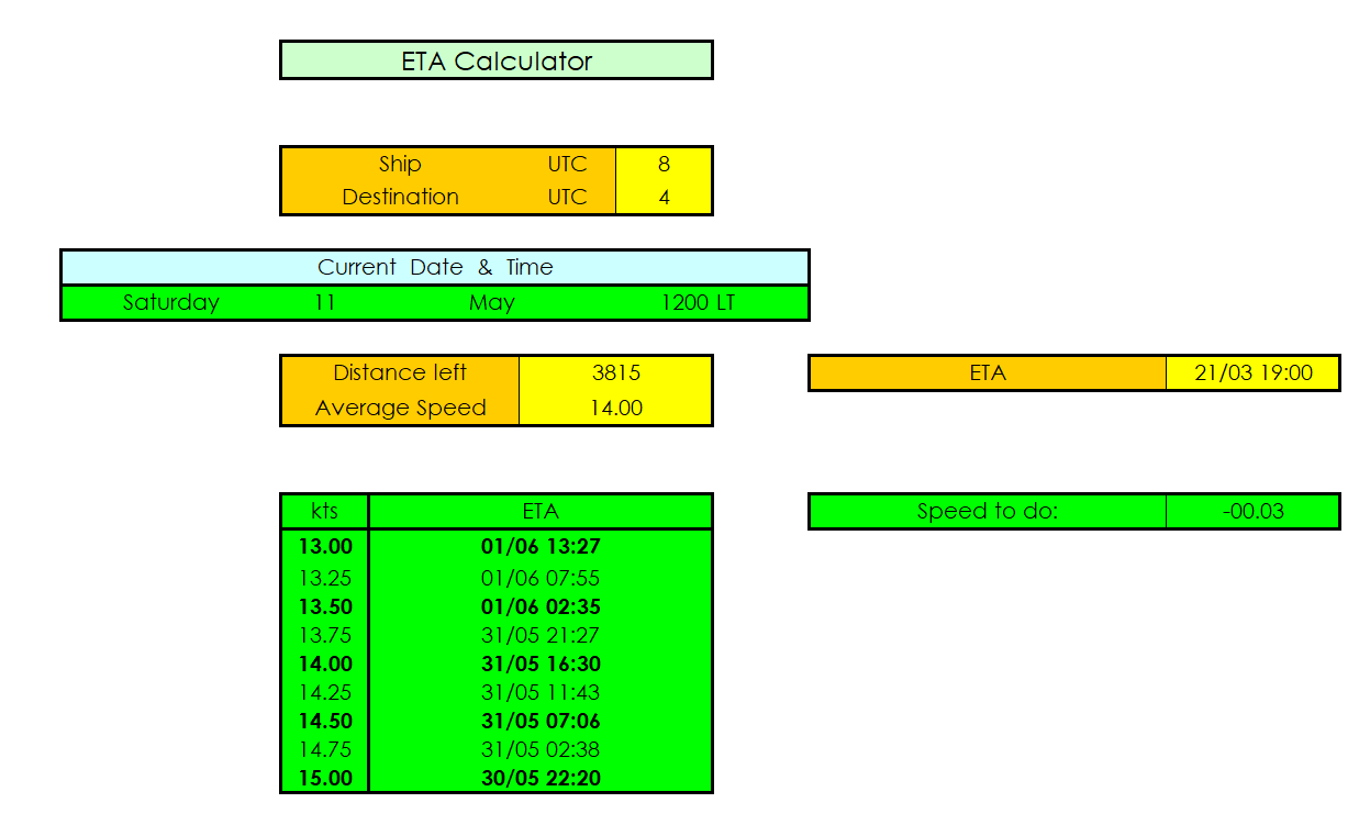
Estimated Time of Arrival (ETA) Calculator
This downloadable tool is designed specifically for seafarers to effortlessly calculate the estimated time of arrival (ETA) for their vessels. Seamlessly integrated into an Excel spreadsheet, this user-friendly calculator simplifies the complex calculations involved in determining arrival times, providing accurate results in just a few clicks.
Click the photo to download the file.
Go Back to Downloadable Files Page
- Create account
Welcome to our website!

Vessel Voyage Calculator (Dry Cargo)
This financial model allows the user to calculate and compare 3 different vessel voyage estimations for dry cargoes ships.
Voyage Estimation is the calculation of the profit or loss that a ship will make from a proposed voyage charter. It involves analyzing the costs of chartering the vessel, fuel, port charges, cargo loading and unloading fees, and other related expenses. The ship owner or charterer then compares the estimated cost of the voyage with the expected revenue from the charter to determine the potential return for the voyage.
This financial model template will enable you to:
- Estimate up to 3 different voyage routes and compare them in terms of various operational and profitability metrics.
- Calculate the Gross Freight and Net Freight based on freight rates, commissions, and brokerage.
- Calculate fuel expenses based on vessel speed, vessel consumption at sea, during transits, and in port, as well as fuel prices.
- Calculate days for sea traveling, and loading / discharging, canal transit, bunkering, as well as bad weather allowance.
- Set various expenses related to port disbursements, hiring costs, and other expenses related to the voyage.
- Check the profitability of each voyage in terms of operating and net profit, as well as in terms of gross daily, net daily and TCE.
- Perform sensitivities on profit metrics and assess the risk of the voyage.
- Get an executive summary for each voyage.
- Present through a series of charts the performance and profitability of each voyage.
So, a quick overview of the model, in the contents tab you can see the structure of the model and by clicking on any of the headlines to be redirected to the relevant worksheet.
On the timing tab you can feed the general information for the model such as: model name, responsible, timeline of the model and date and currency conventions.
Additionally, there is a description of the color coding of the model in the same tab. Inputs are always depicted with a yellow fill and blue letters, call ups (that is direct links from other cells) are filled in light blue with blue letters while calculations are depicted with white fill and black characters.
There is also a color coding for the various tabs of the model. Yellow tabs are mostly assumptions tabs, grey tabs are calculations tabs, blue tabs are outputs tabs (that is effectively results or graphs) and finally light blue tabs are admin tabs (for example: the cover page, contents, and checks).
Moving on to the inputs tab, you can adjust the various assumptions of the model based on the specifications and requirements of the voyage. The user can adjust the freight rates, commissions, brokerage, and other costs. You can set the rounding factor to 0,1 or 2 with 0 being the most conservative option in terms of calculations.
The cargo capacity can also be set, along with the constants. Then the user can set the vessel speed and consumption at sea, during canal transit and in port. The fuel prices can also be set accordingly for each available bunkering port.
Moving to the next set of assumptions, the user can set the loading and discharging ports along with their respective rates, and terms applied.
Moving forward the user can set the various legs of the voyage (up to 3 legs), and set the following parameters: from / to, ballast / laden, and nautical miles (where applicable). The user can also set the days spent in the bunkering port, in canal transits, and in adverse weather conditions.
Then the user can set the disbursements at each port, as well as canal transit fees, etc
Finally in the sensitivities the user can set the rate per ton, and the gross hire per day, or the commissions percentage.
The above assumptions can be set for each of the 3 voyages in the tabs (1 Inputs, 2 Inputs and 3 Inputs).
On the calculation tab, all calculations are performed instantly without the need of an excel macro. The calculations follow the same logical flow as the in the inputs tab. As already mentioned, no inputs from the use are needed here, as all the inputs are fed in the yellow cells on the inputs tab only.
On the executive summary tab, the user can see the main assumptions and outputs of the model such as general assumptions, voyage assumptions, bunkering and other assumptions, costs summary, financials in USD and in USD per day, and sensitivities on daily profit metrics, and on absolute profit metrics.
In the Compare tab the user can compare the 3 voyages and see on the columns to the right the best and worst voyage based on each parameter. Additionally, the user can select 2 voyages and direct compare them by observing the percentage differences and the absolute differences of each metric.
Finally, the checks tab where the most critical checks are aggregated in this page. Whenever you see an error message in any page, you should consult this page to see where the error is coming from.
More from this collection

Net Present Value, Internal Rate of Return, Payback Period - Free Template

Scenarios Analysis in Excel - Free Template

Financial Ratios in Excel

Mortgage Calculations
- CLIENT LIST
- CREATE NETPAS ID
- Netpas Tramper New
- Netpas Distance
- Distance M (Mobile)
- Netpas Estimator
- Netpas MMA (Maritime Mail Analyzer)
- Netpas Enterprise API (NEA)
- NVM AIS (Netpas Vessel Monitor AIS) New
- Netpas Tramper
- Plus Package
- Single Product
- FREE TRIAL & DOWNLOAD
- Agent Promotion
- Sponsor Promotion
- Netpas Tramper Single
- Netpas Tramper Business
- Netpas Vessel Monitor
- Personal Information
- Purchase History
- Netpas Coin History
- Register Key
- Still don't have Netpas User ID? Register a new account
"Powerful Voyage Estimation Calculator"
Voyage Estimation
Cargo Relet Estimation
Time Charter Estimation
Bunker Simulation
Freight Simulation
Estimation Analyzer
Loadable Quantity
Laytime Calculator
(S)ECA Distance & Bypass (S)ECA Options
You can estimate the total duration, operation expense, bunkers consumption and other important factors for your voyage.

You can estimate the total profit and other important factors when subletting your cargo.

You can estimate the total profit and other important factors when subletting your vessel.

You can estimate the bunker consumption for (S)ECA, LSDO and LSFO as well as normal IFO and MDO by using Bunker Simulator. It also compares the bunker consumption both at full and eco speed.

You can simulate the daily freight and total profit expected.

You can simulate the most suitable freight and hire with the analyzed table. You can also check out your breakeven point with this analyzer.

The Grain/Bale and MT loadable quantity is provided for loadable calculation. You can also calculate the loadable quantity considering of loading and discharging port draft.

You can estimate the Demurrage and Dispatch.

(S)ECA distance is shown separately on the voyage for your convenience. You will have four(4) options as below for Passing/Bypassing (S)ECA to select suitable for your voyage.

- - Make right and quick decision by various analysis tools
- - Find dominant position in negotiation with supporting data
- - Powerful reporting function provided in Excel and PDF formats
Powerful Estimation Tool for Most of Tramper Business

Netpas Estimator License Policy
Commercial user, how to get free trial, step1. create netpas id, step2. download & install.

Main Functions
Simple switching between voyage and cargo relet estimation.
You can figure out the best business type by converting and comparing the business type with minimum inputting numbers. You can switch Voyage Estimation into Cargo Relet Estimation, or vise versa, by simply clicking "Copy to Voyage or Cargo Relet Sheet”. The data is copied from/to each other.
- Netpas Enterprise API
- Netpas Tramper Plus
- Distance Plus
- Estimator Plus
- Netpas Suite
- Netpas Supreme
- Netpas Coin
FreeTrial&Download
- - App Store
- - Google Play
Agent & Sponsor
- - Netpas Distance
- - Distance M
- - Netpas Estimator
- - Netpas MMA (Maritime Mail Analyzer)
- - Netpas Vessel Monitor
- - Netpas Tramper Single
- - Netpas Tramper Business
2024 © Seafuture Inc. All Rights Reserved. Privacy Policy | Terms of Service
IMAGES
VIDEO
COMMENTS
Voyage Calculator; Advertise; Contact us; Port of Departure ... Vessel speed, knots: Result. Not calculated yet. DESCRIPTION. SEA DISTANCES / PORT DISTANCES - online tool for calculation distances between sea ports. More than 4.000.000 distances. More than 4000 sea ports.
Shipping Distance & Time Calculator. Distance & Time is web application, which allows to calculate distances and transit time between two points using different modes of transport. Cargo Calculator for instant Container Shipping Distance & Time. Optimize shipments effortlessly with our Sea Distance Calculator for timely deliveries.
find destination port: start typing to see the suggestions. calculate. +. Calculate sea route and distance for any 2 ports in the world.
MARINE VESSEL TRAFFIC. Live Ships Tracker, Fleet Analyses, Cruise Offers. ... Container Tracker Distance Calculator Nautical Chart IMPA Codes Search Bunker Prices Baltic Dry Index Incoterms Pallets MID Codes Piracy Map 2024 Flag Statistics World Fleet by Ship Type World Fleet by Ship Flag Global Sea Routes Who is Who Navigable Rivers Postal ...
Thus, you can customise your itinerary as you wish, start/end your voyage, or pass by any waypoint you want your vessel to head through. Great Circle VS Rhumbline Seametrix is the only sea distance calculator that offers correct and real-world Rhumbline & Great-Circle nautical mile calculation results.
View suitable yachts now. Booking Advisor. Let a travel expert suggest the ideal yachts for your trip. Verify your phone number. Your phone number is required so the owner & the captain can contact you during your trip. Add new number. Send Confirmation Code. SavedRetry. Enter the 4-digit confirmation code below:
The sea route calculator is available in both products; ShipAtlas and ShipIntel. It will give you the shortest route from any vessel's AIS position in the map to any port or combination of ports, and find the distance, time and ETA. You can also route between ports. If you want to change the route on web; click and drag the route (same as you ...
Route Planner improves operational efficiency by route optimisation for any sea passage. Speed profile, ECA zone avoidance, and gateway preference help you to compare various routes.
Sea-SeekDistance Calculator. Navigation tools. Distance and route computation.
Sea Distance Calculator. Shiptraffic.net is a maritime website monitoring ship traffic in 14 different types of geo regions like Seas, Straits, Canals, Sounds, Reefs etc., stating their geographical coordinates by latitude and longitude around the world. We show ships current positions and marine traffic through the embedded maps of ...
Sea route calculator. Get distances in nm from any vessel's AIS position to any port, or port to port. Find ETA, days at sea, bunker ports along your route and estimated bunker consumption. Add info layers to your route such as ECA/SECA zones (IMO and local), daily updated marine weather, piracy info and sea ice conditions.
Calculate Distance. You can easily calculate/measure the distance between a vessel and any other Waypoint as defined by you. To start, simply right-click anywhere on the Live Map and select the Distance From Here option to set it as your starting point. A yellow pin marker will be placed on the selected vessel or point on the Live Map.
Freight shipping transit time is impacted by factors including distance, shipping mode, route, and season. In very rough estimates: express can take as little as 1-3 days, air freight is typically 5-10 days, and sea shipping can range anywhere from 20-45 days or more. The complexity of customs procedures and potential delays at border crossings ...
The Voyage Planner is an efficient tool of Live Map Toolbar, that will help you estimate profitability, plan and track voyages, all in one place. In this article, you will learn how to use the Voyage Planner and start planning your vessel's voyage. Setting up the route. Estimating Turnaround Time.
Our new Smart Calculator is an AXSDry tool allowing them to run quick voyage calculations for multiple vessels. The new calculator takes all the essential information for a voyage and returns its results simultaneously for each vessel in a simple grid. Its users have the option to input commodity types, quantities and tolerance, load and ...
Voyage Estimation is the calculation of the profit or loss that a ship will make from a proposed voyage charter. It involves analyzing the costs of chartering the vessel, fuel, port charges, cargo loading and unloading fees, and other related expenses. The ship owner or charterer then compares the estimated cost of the voyage with the expected ...
CO2e emissions calculator. Accurately compute your carbon emissions from freight transport, and automatically generate reports of your past bookings. ... Manage your fleet or containers efficiently with live positions, and enhance it with voyage information, vessel details, distance to the next call and our estimated time of arrival. Retrieve ...
This downloadable tool is designed specifically for seafarers to effortlessly calculate the estimated time of arrival (ETA) for their vessels. Seamlessly integrated into an Excel spreadsheet, this user-friendly calculator simplifies the complex calculations involved in determining arrival times, providing accurate results in just a few clicks ...
Vessel Voyage Calculator Dry Cargo. This financial model allows the user to calculate and compare 3 different vessel voyage estimations for dry cargoes ships. Voyage Estimation is the calculation of the profit or loss that a ship will make from a proposed voyage charter. It involves analyzing the costs of chartering the vessel, fuel, port ...
Learn more about our features that let you plan for a greener voyage. Explore or Cancel Optimization tools. Calculator ... The draft of the vessel in meters Vessel draft: draft. Vessel speed: 21 knots ... Our CO 2 e emissions calculator is an application to calculate your scope 3 emissions for all transport modes (sea, air, road, rail and barge ...
This financial model allows the user to calculate and compare 3 different vessel voyage estimations for dry cargo ships. Voyage Estimation is the calculation of the profit or loss that a ship will make from a proposed voyage charter. It involves analyzing the costs of chartering the vessel, fuel, port charges, cargo loading and unloading fees ...
Netpas Estimator is an unique and practical calculator for tramper business sector. It is a perfect tool for most of the major types of tramper business such as Voyage, Cargo Relet and Time Charter. Each type of business can be easily compared so that you can figure out the best type of business. With the same vessel, you can evaluate and ...