
An Insider’s Guide to Rysy Summit – Polish and Slovak Trails and Info
- TATRA MOUNTAINS
If you’re a hiking enthusiast like me, Rysy Peak should be on your bucket list. I was there and can share most important info you may find nowhere else. Why, you may ask? Well, Rysy isn’t just any old mountain. It’s the highest peak in the Tatra range from the Polish side and a hot spot for tourists from all corners of the world. But here’s something I bet you didn’t know – Rysy boasts not one, not two, but three summits!
The middle summit of Rysy in Tatra Mountains is standing tall at 2499 meters is the highest peak in Poland, while the other two are nestled on the Slovak side with the highest reaching 2501 meters, and the other at 2473 meters. If you want to know, the highest peak situated entirely in Poland is Kozi Wierch , a part of the famous Orla Perć range.
Your Hike to Rysy Peak in the Tatra Mountains
Trail: Palenica Białczańska – Morskie Oko – Czarny Staw – Bula pod Rysami – Rysy. Duration for both ways: 11h 42 min, Distance: 24.9 km, Elevation: 1929 m
- The trail to Rysy might be a tough cookie, but it’s well worth it
- Did I mention, Rysy is the highest peak in Poland?
- Brace yourself for chains and exposure on your way up
- Always have travel insurance (just in case you tumble over to the Slovak side)
How Many People Make the Climb to Rysy? Which Path to Take?
The peak is accessible only by the red trail . So, I think when it comes to your plan to conquer Rysy, you’ve got two choices – either go Polish or go Slovak side. If you need a challenge , the Polish trail will test your mettle. It involves walking the famed asphalt road, waving hello to Morskie Oko , and then embarking on an uphill journey via Czarny Staw.
↳ Before you head to Tatra Park, I highly recommend reading my complete guide to Tatra Mountains . I showcase the most scenic places you won't want to miss. Make sure to check it out, so you don't overlook anything interesting : Tatra Mountains – An Insider’s Guide to All Attractions and Info
The Slovak trail , on the other hand, starts at the cozy Chata pod Rysami hostel. The Polish trail is no walk in the park – it’s technically more demanding with more chains and greater exposure. Plus, it boasts a considerably higher elevation. But if you’re not up for that, or if you’ve already trekked the Morskie Oko Rysy route, the Slovak trail is a good alternative.
The Trip to Rysy from the Slovak side is covered in the second part of this post.
Did you know there’s a third option for your adventure to Rysy? If you’re up for it, you can ascend from one side and descend from the other. Sounds exciting , doesn’t it? But, I believe this requires a bit more planning , especially when it comes to logistics.
Don’t worry though, I’ve done it myself and got you covered with some handy tips at the end of this post. But first, let’s break down the stats for each route:
1. Polish Trail: (here is my suggested accommodation which is closest to this trail) Palenica Białczańska – Morskie Oko – Rysy + return:
- Duration: 11h 42 min
- Elevation: 1929 m
- Distance: 24.9 km
2. Slovak Trail: (here is my suggested accomodation that is closest possible to the trail) Popradske Pleso – Chata pod Rysami – Rysy + return:
- Duration: 8h 40 min
- Elevation: 1449 m
- Distance: 18.9 km
3. Mixed Route (Poland – Rysy – Slovakia): For this option I suggest this accomodation and in the morning find a ride to Palenica Białczańska so after the hike, you are close to the hotel. Palenica Białczańska – Rysy – Popradske Pleso:
- Duration: 10h 31 min
- Altitude gain: 1820 m
- Distance: 21.9 km
4. Mixed Route (Slovakia – Rysy – Poland) – For this option I suggest this accomodation and in the morning find a ride to Popradske Pleso so after the hike, you are close to the hotel.
Popradske Pleso – Rysy – Palenica Białczańska:
- Duration: 9h 51 min
- Elevation: 1558 m
The Trail to Rysy From Morskie Oko in Poland – A Breakdown
Route: Palenica Białczańska – Morskie Oko – Czarny Staw. Time: 3h 15 min, Distance: 9.5 km, Elevation: 715 m
Here’s some useful info on reaching Morskie Oko (how to get there from Zakopane , where to park, and a trail description can be found by clicking the red text). Let’s keep it short for now. Expect to pay PLN 30 per day for parking at Palenica Białczańska .
Honestly, even off-season, you’re unlikely to be alone on the trail , but it’s worth to say that hitting the road early can help you dodge the crowd at the chains. Another perk of being an early bird? You’ll complete the trail quicker and have a good shot at avoiding any sudden weather changes .
After all, mountain weather is usually friendlier in the morning than in the afternoon. The route to Morskie Oko is an 8 km asphalt road that you can conquer in a little over 2 hours. The red trail cuts through the asphalt serpentine four times, roughly in the middle of the road. Most folks cover this part while it’s still dark or just breaking dawn.
If you’re thinking of overnighting at the Morskie Oko shelter, that’s a great idea! It’ll make your trek to Rysy significantly shorter . However, keep in mind that securing a spot at the hostel can be quite challenging. Alternatively you can stay in the closest possible location to the Palenica Bialczanska. This place is small village called Javorina in Slovakia – here is available accomodation .
If you do not care about the distance so much, then I suggest that you stay in Zakopane. Here are my top three picks across different price ranges in terms of accommodation in Zakopane:
- (€) Hotel Tatra : A brilliant, budget-friendly modern 3-star which is located in Zakopane, at an altitude of 1080 meters above sea level. It has indoor swimming pool, free Wi-Fi and classically furnished rooms with a beautiful view of the Tatra Mountains.
- (€) ❤️ Bachleda Residence Zakopane : A gorgeous hotel located less than 1 km from Aqua Park Zakopane. There is a bar and private parking on site. There is a restaurant in the facility. It offers air-conditioned luxurious rooms. Beautifull place!
- (€) Hotel Paryski Art&Business : This 4-star hotel has a seasonal outdoor swimming pool, free private parking, a garden and a shared lounge. It offers a restaurant, a terrace, an indoor swimming pool and a sauna.
To make the journey more manageable, I’ve split the trail from Morskie Oko to Rysy into three stages:
- Reaching Czarny Staw / Black Pond (1h)
- The demanding hike to Bula pod Rysami (2h)
- The final ascent to the Rysy Summit (1h)
In total, this takes about 4 hours , with the last stage mostly along a secured section.
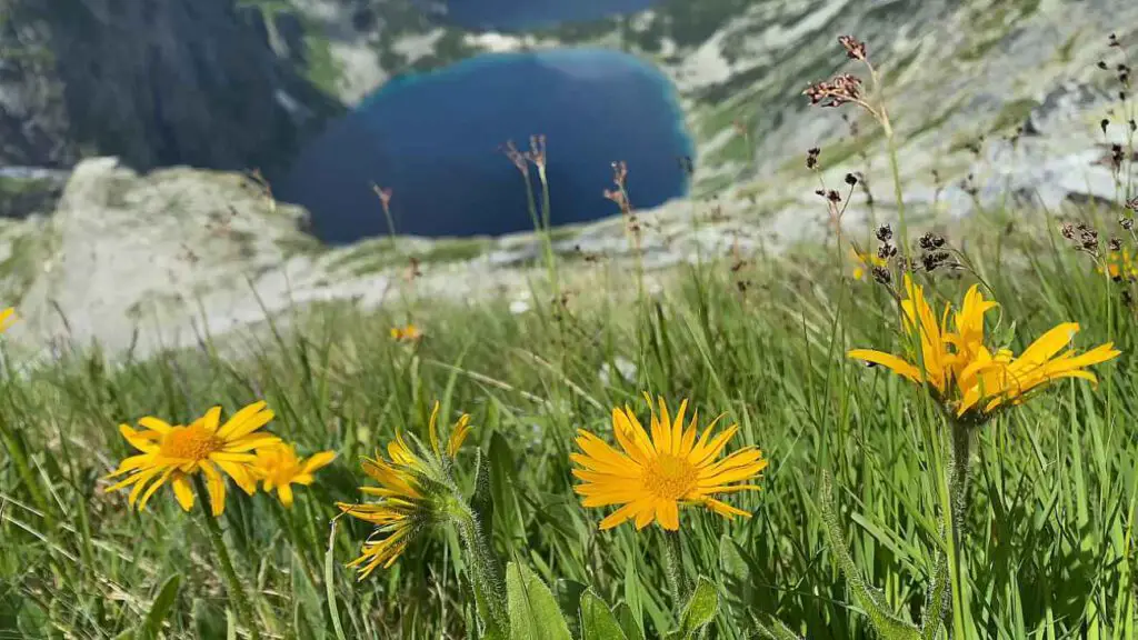
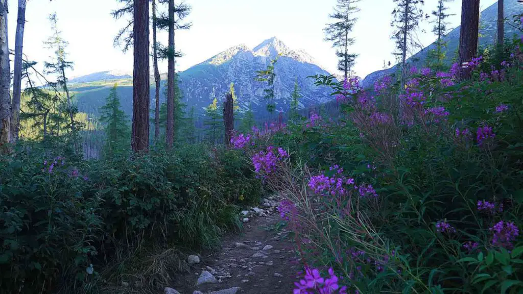
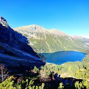
The trail to Rysy veers left around Morskie Oko . This stunning lake, with a depth of 54 meters, beautifully mirrors the surrounding peaks of Mięgusze and Mnich . The path quickly shifts into a steep climb, giving you a taste of the adventure that lies ahead.
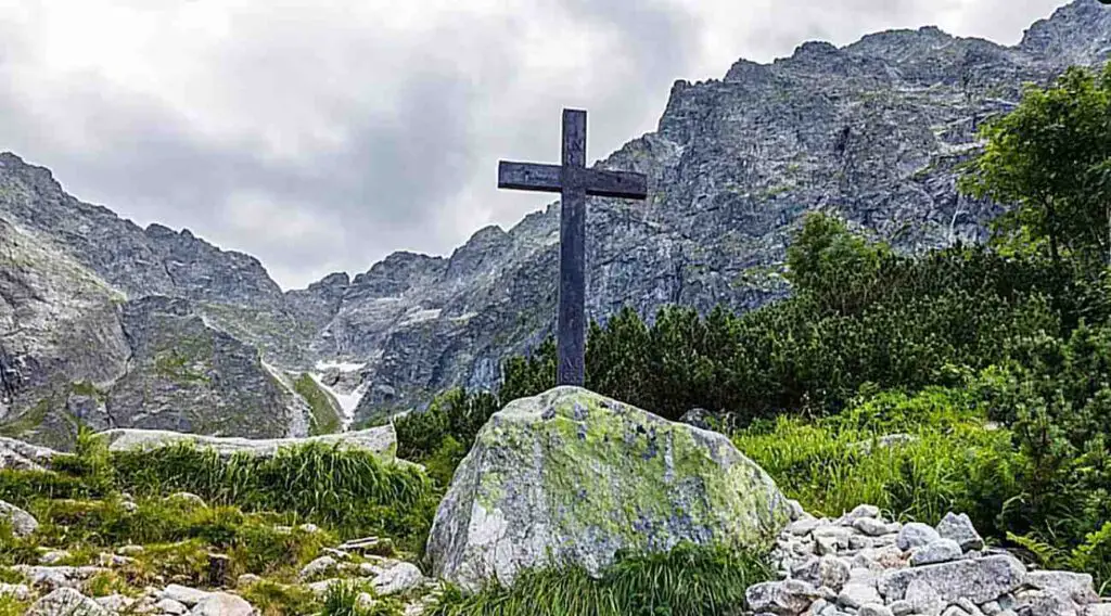
It winds by the Czarnostawski Waterfall up to the threshold of Czarny Staw (Black Pond ). Here, a wooden cross and a breathtaking granite amphitheater welcome you. To the right, you’ll see the imposing Mięguszowiecka Kazalnica and its companions. There’s also a Smoking Waterfall . I can tell, this spot is perfect for a quick bite to refuel your energy.
Hiking From the Black Pond to Bula Near Rysy
Time: 2h, Distance: 2.1 km, Elevation: 551 m
At the cross, you’ll encounter the final trail split of the day. The green markers veer right, pointing towards Mięguszowiecka Przełęcz pod Chłopkiem (a 2h 45 min climb). On the other hand, the red markers leading to Rysy swing in the opposite direction. From this spot, it’s about a 3 hour 20 minute trek to the summit. The trail initially meanders quietly around the pond on the left, then kicks into high gear with a steep climb.
You could say playtime’s over. Yes, it’s going to be tough, but technically it’s straightforward.
A rocky path leads to Bula , snaking through stone rubble. The scenery here is something else – you can really feel the raw power and majesty of the mountains . If you’re hiking early in the morning, before the sun’s had a chance to brighten the route, it might even feel a bit gloomy for some.
Roughly 1.5 hours from the cross, you’ll come across a masive boulder that offers a breathtaking panorama. This boulder sits on the Long Scree. The view of both ponds below is so mesmerizing that queues form not just for the chains on the trail.
Pretty much everyone waits their turn to snap a few shots for their photo album. Once you’ve captured the moment, you’re just a few bends and a straight stretch away from Bula pod Rysami – around 25 minutes, give or take.
If you need a snack, the area around Bula is an excellent spot. There’s a bit of flat land, the views are spectacular, and soon you’ll be walking alongside metal chains for support. Take a moment to appreciate Tomkowe Igły – these are distinctive sharp crags.
The flat part of Bula near Rysy is often used by TOPR as a helicopter landing pad during rescue operations in the area. Just bear in mind it’s noticeably chillier here than by the pond – altitude and shade make for a cool combo in this spot. And Bula pod Rysami is perched at a height of 2054 m.
The Final Ascent – Bula Near Rysy to Rysy Peak at 2499m
Time: 1h 19 min, Distance: 0.8 km, Elevation: 404 m
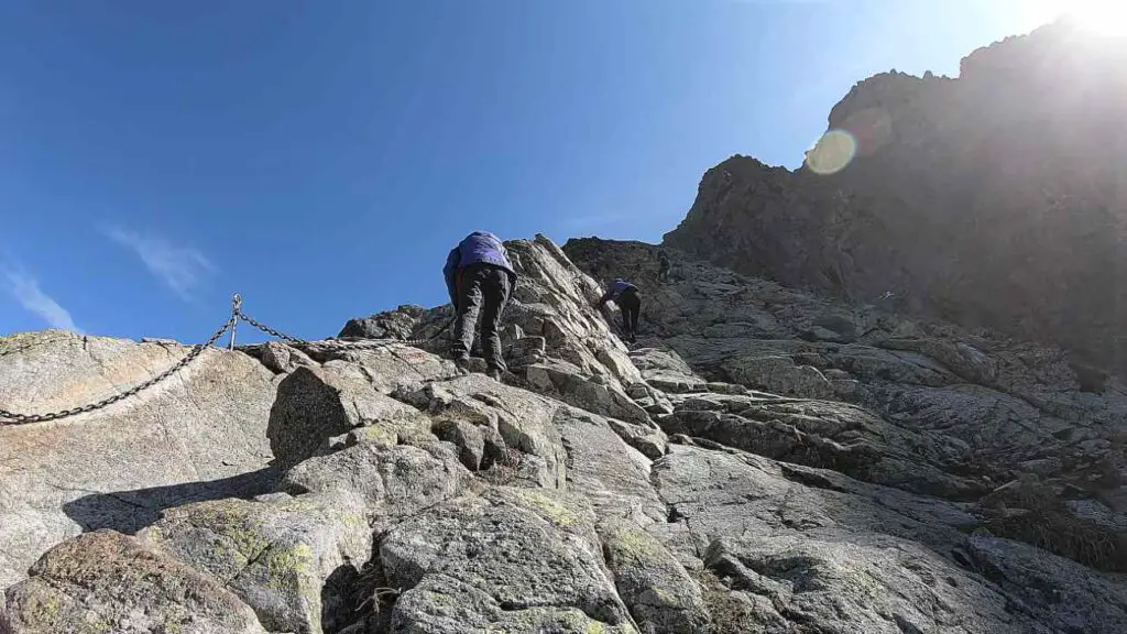
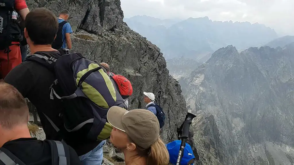
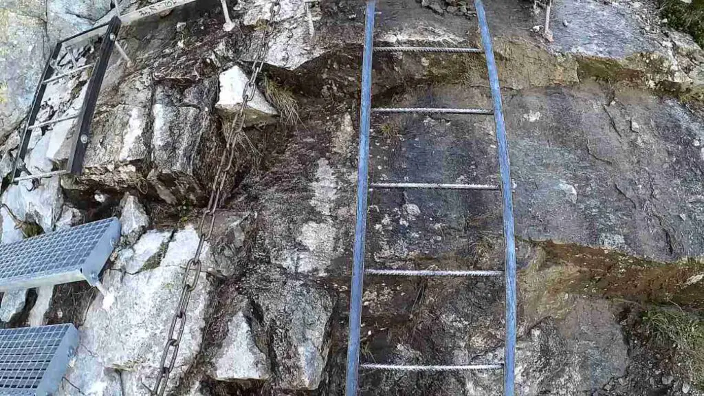
This is where the real adventure kicks in. Just past Bula, you’ll encounter the first set of chains that will accompany you nearly all the way to the top. The metal journey starts off gently, the heights aren’t too scary, and the chains rest easily on the rock formations. But it ramps up as you progress.
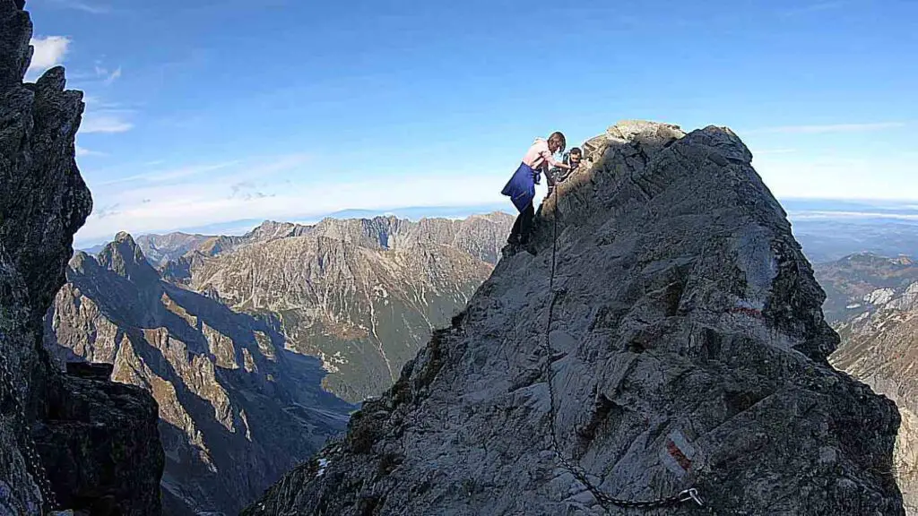
As you hold on to the chains , you’ll find yourself on a rocky ledge. To its right, you’ll see a large scratch – some mistakenly think this is where the peak gets its name. There’s no denying that the trail is well-equipped with safety chains – a whopping 360 meters of it
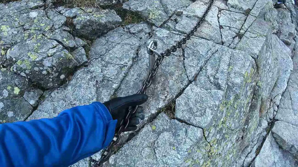
. These chains guide you over rocky blocks and smooth, slippery slabs. There will be several spots that require some climbing, and the views behind you will get your heart pumping. But don’t worry – there are plenty of spots where you can stop and catch your breath safely.
The safety chains end just short of the ridge, a few meters below the peak. This is where, in my opinion, the toughest part awaits. It’s a short, exposed, narrow traverse through the Pass under Rysy.
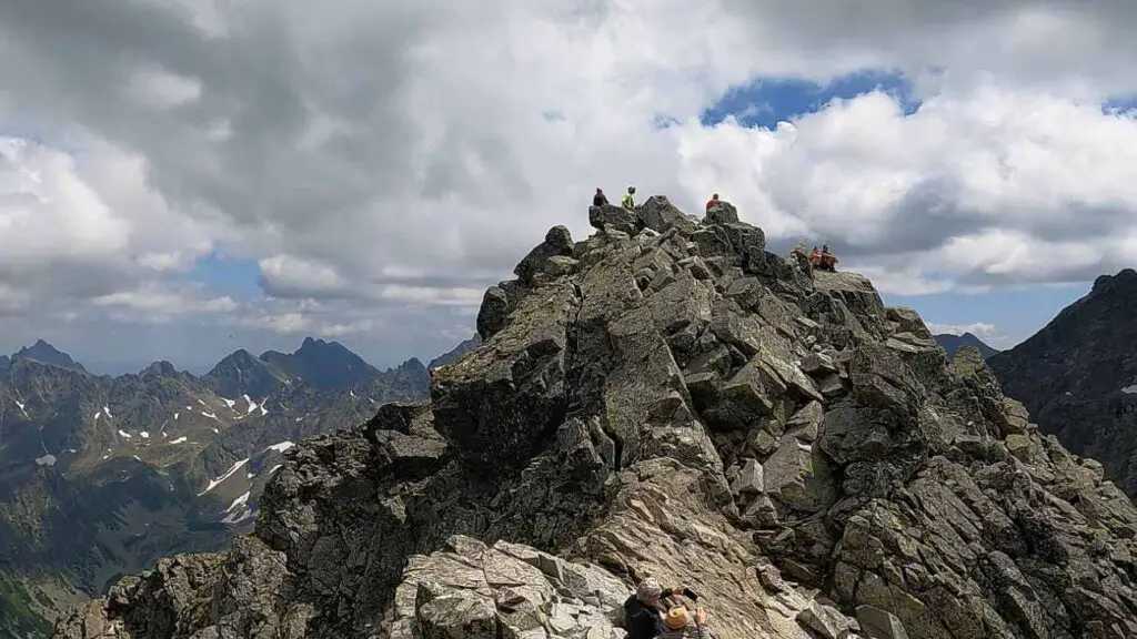
With several hundred meters of void on either side, the safety chains provide some much-needed reasurance. After you’ve navigated this section, a quick loop around the peak and you’ve made it:
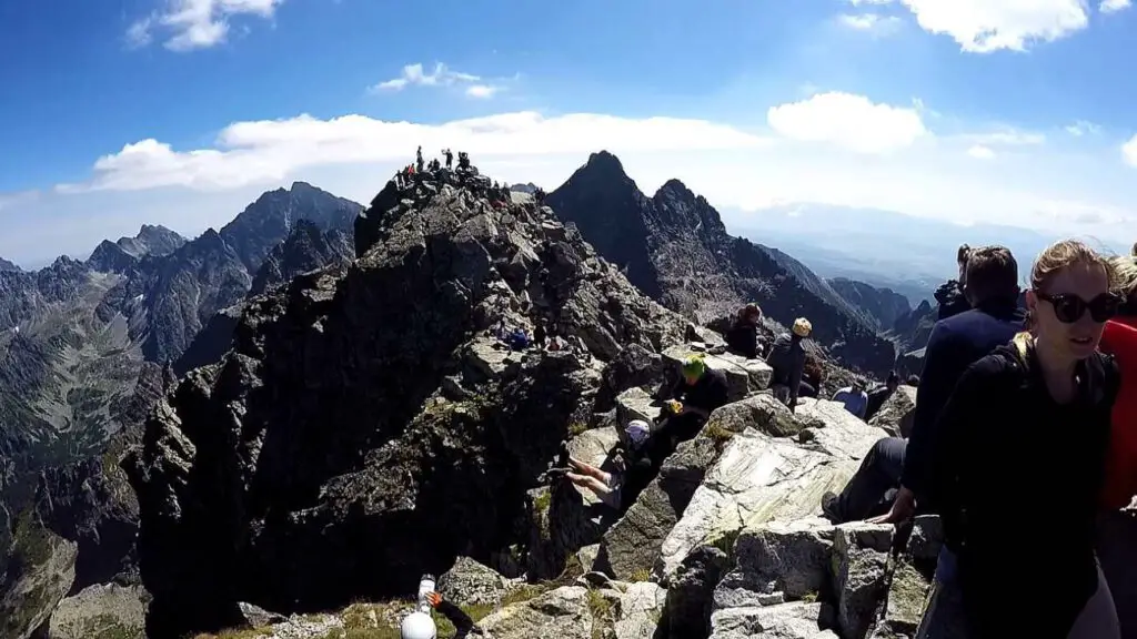
Congratulations, you’re standing at the highest point in Poland!
It doesn’t get any higher than this! Rysy is a magnet for tourists, and over the years it’s been graced by the likes of Maria Skłodowska-Curie and her husband Piotr, and even Vladimir Ilyich Lenin. In fact, there’s a plaque at the peak commemorating Lenin’s visit, though it’s been repeatedly battered by the „restless winds” that whip through this area.
„Rysy” Means „Scratches”
Just past Bula, the trail rapidly ascends a rocky ridge, growing steeper, with a noticeable, long fissure on the right side. It’s here that the winter variant of the climb to the summit exists. You might come across the interpretation that the name of the peak originates from this fissure .
This, however, is only half the story – the name 'Rysy’ truly originates from the furrowed slopes of the entire massif, which includes Niżnie Rysy, Żabi Szczyt Wyżni, and Żabi Mnich . And there, the mystery of the name is resolved.
Is Rysy Summit Suitable for Beginners?
In my opinion, the technical challenges on dry rock and without snow are generally moderate. Yet, I don’t suggest this trail as your first experience with chain-assisted mountain hiking without local guide assistance. So, embarking on Rysy as a very beginner mountaineer might not be the best idea without assistance, however is doable.
- Before hitting the trail I encourage you to read this article first: Understanding the Risks – Tatra Mountains Death Statistics
↳ Book the guided hiking expedition to Rysy in Tatras by clicking here!
It’s advisable to first experience how you respond to exposure and how comfortable you are with the chains. Therefore, before attempting Rysy, I suggest trying out routes like Szpiglasowy Wierch from the side of the Valley of Five Ponds or Świnica .
Interestingly, despite the challenges that hikers face on the trail, Rysy is one of the most frequented peaks. Hence, there are probably a lot of queries from less experienced hikers: which is tougher, Rysy or Giewont? For me, there’s no doubt – Rysy is considerably more challenging , both physically and technically.
- If you are also considering hiking to Giewont Peak , then I suggest you read this fascinating article too.
However, if you’re accustomed to hiking and rock climbing with chains, we have good news – the trail to Rysy shouldn’t pose much of a problem. All of this, of course, assuming there’s no snow on the trail and the rock is dry.
But it’s worth noting that snow tends to linger here for quite some time , which heightens the risk of falling. So, be cautious and sensible. But under favorable conditions, for those who enjoy such trail bonuses, it’ll be a rewarding, albeit steep, hike.
A Brief History of the Trail Safety Chains
The history of the chains on this section dates back to 1886, when the first clamps were installed. Interestingly, the trail wasn’t marked until 12 years later. There are ordinary stretches between sequences of chains, so it’s not as if a constant vertical climb awaits you from Bula . In my opinion, the most dangerous aspect isn’t the difficulty of the trail itself, but the encounters with hikers moving in the opposite direction .
Other hazards on the trail include patches of frozen snow that persist until late spring and even into summer . Be mindful of the length of the day – in spring and autumn you’ll have considerably less time for the entire hike. Remember, a winter trip to Rysy is an entirely different ball game and is recommended only for experienced mountaineers.
At the very least, crampons and an ice axe will be necessary for such an expedition. To sum up – Are the 'Rysy’ difficult to scale? The trail is moderately challenging in the summer, but you should be aware of the risks and what you might encounter along the route.
Poland’s Highest Peak
While Rysy is the indisputable highest point in Poland for us, it holds a somewhat distant position in the Tatra hierarchy. The situation is slightly ameliorated when we consider only those peaks that have marked trails leading to them. In this case, Rysy takes a considerable lead as the highest peak in the Tatra Mountains.
Now, the most important part – if you want to fully claim the peak as conquered, you should extend your effort a little further to the Slovak side . Right ahead of you, more or less in a southerly direction, stands its meter-taller sibling. The distance isn’t great. You just need to traverse a small switchback (with significant exposure on the left) and clamber over large boulders to reach your destination.
This final stretch will likely take you about 2 minutes and then the summit is yours! The last, lowest peak is also located near our neighbors and is closest to the Waga Pass, boasting a height of 2,473 m.
Panorama From the Rysy Summit
The thrill of reaching the summit is immense. And the entire experience is amplified by the views that literally take your breath away! It’s said that up to 100 peaks can be seen from here . I didn’t count, but you can undoubtedly spot all the highlights. After all, Rysy is situated at the heart of the Tatra Mountains.
You can see Ganek, Konczysta , and even the Tatra king and ruler, i.e., Gerlach . Koprowy and Krywań peeking from behind him are a beautiful sight. It’s also worth looking down towards the valleys: Cieszka, Mięguszowiecka, and the one you hiked through today, i.e., the Rybi Potok Valley . The still-undiscovered and highly recommended by me Belianske Tatras are also in sight.
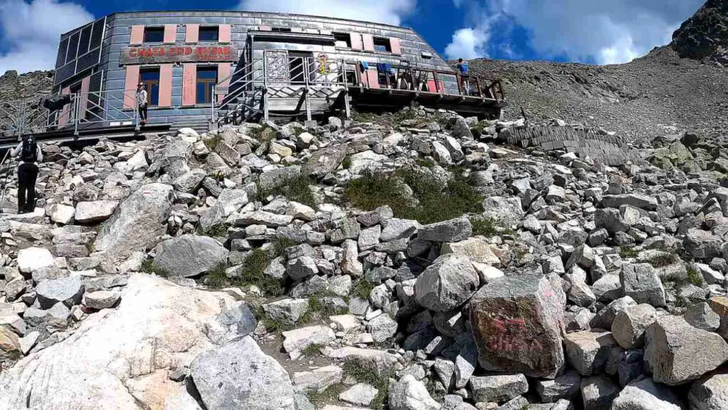
„ Chata pod Rysami ” Hostel and Shelter
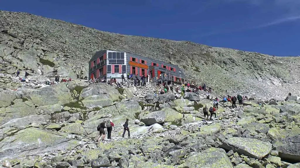
Descending from the summit to the Schronisko pod Rysami (Shelter under Rysy) and then climbing back up to Rysy takes an additional 80 minutes.
- Location of the Shelter / Hostel: Click Here
So, it’s 35 minutes down to the shelter and 45 minutes back up. If you feel up to the task, I highly recommend it. Just remember that descending to the Slovak side is only possible during the summer and autumn months – from June 16 to October 31.
You’ll have to account for an additional 270 meters of elevation gain in your trip . The trail from the summit to the shelter isn’t technically challenging or complicated. There are no safety chains here, and the views are simply magnificent! High appears particularly impressive from here.
The Schronisko pod Rysami is also often referred to as the Schronisko pod Wagą (Shelter under the Scale) due to the nearby pass under which it’s located. The shelter stands at an altitude of 2,250 m, in the upper part of the Żabia Mięguszowiecka Valley. Originally, even before the first shelter was built here in 1933, serious consideration was given to the construction of a large hostel.
↳ Check the closest accommodation to this hiking route by clicking here!
Fortunately, after protests from mountain lovers, the project was abandoned and a small shelter was built instead. Admittedly, the shelter has not had an easy life here. Many times in its history it was destroyed and devastated by avalanches, only to be painstakingly repaired.
Voices were raised suggesting that the shelter should be moved to a safer location. However, it was decided instead to significantly rebuild the shelter so that it could withstand future winter battles with avalanches. It’s worth emphasizing that there is no road leading to the shelter.
All supplies are brought in by so-called „carriers” or by ordinary tourists. For the latter, special parcels weighing up to 10 kg have been prepared. For their effort, each brave soul will be rewarded with tea and raspberry juice.
Interestingly, it’s not the shelter building that is the most recognizable structure in the area. That title goes to the toilet suspended over the abyss, which offers a delightful view! Especially considering that the front wall is made entirely of transparent organic glass.
Return via Morskie Oko or Go To Slovakia?
According to the trails, descending from the top to Morskie Oko Lake will take you around 3 hours and 15 minutes. However, during the peak season, expect to add a bit more time due to the heavy trail traffic and queues at the chains. At the end of the descent, another 8 km of arguably charmless asphalt hike awaits you to reach the parking lot (around 1 hour and 50 minutes).
In total, you should allow about 5 hours from the summit to the parking lot. For this reason, many hikers find it more attractive to descend on the Slovak side, passing by the Chata pod Rysami shelter towards Popradskie Pleso.
I highly recommend this route. Just remember that due to Slovak restrictions, the trail is only open from June 16 to October 31. Here are some of our comments on this option.
Return via Slovakia – 3 Stages
If you’re considering this option, plan your logistics for returning from Rysy through Slovakia ahead of time. It’s not a decision to be made spontaneously at the summit. The descent from the peak to the nearest tram station (Popradské Pleso) takes about 4 hours.
Now the crucial part – in the Slovak transportation search engine you can check connections to Łysa Polana. Despite the relatively short distance, returning to the border by public transport can paradoxically be quite time-consuming. The journey is only 50 km, but it can take you about 2 hours.
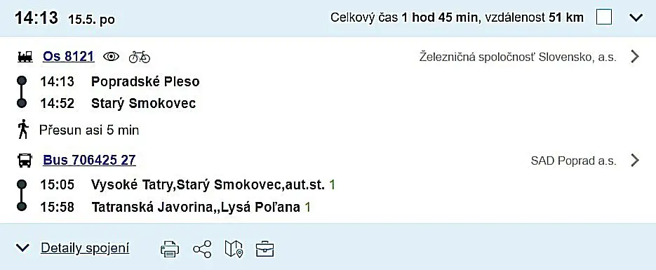
The journey should be broken down into three stages. First, you need to reach Stary Smokovec by elektricka, where after a 100 meter walk, you’ll arrive at the bus stop . From the train station, you’ll have to walk along the building, following the footpath in the opposite direction to the way you came.
You’ll soon arrive at a large square, largely used as a parking lot, from where buses to Łysa Polana depart. The ticket for the ride costs €2.3 and can be purchased from the driver. The Polish company Strama’s buses, which operate on the Zakopane – Poprad route, also stop here.
Once you reach the border, you’ll simply have to walk across the border bridge and, if you’re lucky, catch a bus to Palenica Białczańska. If there’s no bus in sight, you’ll have a 1.5 km walk ahead of you.
You can purchase tickets for the elektricka online – here.
„Safety First” When Climbing to Rysy
- Your physical fitness needs to be up to par, as the journey will likely take you around 12 hours, with a cumulative elevation gain of 1900 meters.
- Given that Rysy is a border peak, ensure you are covered by insurance for the Slovak Tatras .
- Don’t forget to pack warm clothing . The trail to Rysy passes through a quite shaded section, where snow tends to linger for a long time, even in the summer.
- The trail is quite popular, so to avoid overcrowding and queues at the chains, it’s advisable to start very early.
- Remember to carry headlamps during shorter days, as there’s a good chance you’ll be returning after dark.
- Rysy in winter offers a completely different experience. The trail is only recommended for seasoned hikers ( crampons and ice axe are compulsory ).
- Always check the weather forecasts – you can do so here .
Considering The Local Guide To Rysy Summit
If you’re someone who loves a good adventure, let me say, the Tatra trails are an unbeatable experience. Especially when you’re hiking to Rysy, having a guide by your side is like having a safety net. You wouldn’t have to worry about straying off the path, and there’s a good chance you’ll stumble upon parts of the Tatras that would’ve been undiscovered territory, had you been alone.
Consider your guide as a storyteller, a person who breathes life into the scenic vistas around you. They spin tales about the mountains, the trails, the history, making your journey far more engaging. I am convinced, the journey becomes so much more interesting when you’ve got a personal narrator along the way, wouldn’t you agree?
Ensuring Safety with the Local Tatra Guide
If you’re a newbie to the world of hiking, it is worth to say, hiring a local Tatra guide to take you to Rysy is a smart choice. The guide ensures that you stay safe while you marvel at the beauty of the Tatra Mountains.
You see, these mountains can be unpredictable, and having an expert by your side gives you the confidence to embrace the adventure , while also making sure you’re safe and sound. So remember, when you’re there, you need to know that safety should always be a priority.
↳ Book adventurous Rysy Hiking Trip with Guide by clicking here!
Key Facts About Rysy Summit
How many peaks does Rysy have? It’s a tricky question, as there are three peaks. Two of them lie on the Slovak side, reaching heights of 2501 m and 2473 m respectively. The third peak, our Rysy, stands at 2499 m and is the highest peak in Poland.
Who first climbed Rysy? The first summer ascent was made by Eduard Blásy and his guide, Ján Ruman Driečny the Elder, on July 30, 1840 . The first winter ascent of Rysy was carried out by Theodor Wundt and his guide Jakob Horvay on April 10, 1884.
Where does the name 'Rysy’ originate? It is believed to derive from the cracks seen on the walls of Niżni Rysy, Żabi Mnich, and Żabie Szczyt Wyżni .
The trail to Rysy was marked with red paint in 1898 . Interestingly, metallic chains (safety measures) had been installed here 13 years earlier. As such, the official date of opening the route to Rysy is recognized as 1886 .
- Regarding accidents and fatalities, it’s estimated that up to 100 people have lost their lives on the journey to the peak . This figure includes both routes (Slovak and Polish).
- You may also want to read this article: Mysterious Tragedy in the Tatras – The Unsolved Deaths in 1925
Although Rysy ranks as the 17th tallest peak in the Tatras , it’s the first one that the trail leads to. The panorama from the summit is truly stunning , purportedly offering views of up to 100 other peaks.
Practical Information
- Parking at Palenica Białczańska will cost you PLN 30 per day.
- You can learn more about buses and timetable from Zakopane – here .
- Remember, the descent to the Slovak side is only possible during summer (from June 16 to October 31).
- You can find a map of Rysy – here .
- Rysy stands tall at 2499 m (at least the Polish peak, hence, it is the highest mountain in Poland).
- For a detailed description of the trail to Morskie Oko, click here .
- Note that there is an entrance fee for the TPN (Tatra National Park) – you can find the price list here.
- Don’t forget to pack headlamps and warm clothing.
- It is crucial to check weather forecasts and purchase insurance (since this is a border route) before heading to the mountains. In Slovakia Rescue Team is Paid by you, unless you have insurance. In Poland it is covered by government.
- The trail to Rysy is technically challenging and is not recommended for those unfamiliar with using chains. It’s also quite strenuous, as the elevation gain from Morskie Oko is 1,100 meters.
Slovak Trail to Rysy – A Guide
Route: Popradzki Pond – Mięguszowiecka Valley – Crossroads on Żabi Potok – Chata pod Rysami – Rysy. Return Time: 8h 40 min, Distance: 18.9 km, Elevation: 1409 m
- The trail to Rysy from the Slovak side is rated as moderately difficult.
- There are insured sections on this trail.
- The trail (Red) is open from June 16 to October 31.
- Remember to obtain insurance for the Slovak mountains.
Ascending Rysy from the Slovak side is a far simpler option than scaling it from the Polish side. Is it worth taking this route to the peak? Absolutely! Not only to experience the terrain on the other side of the border, but to also appreciate the captivating panoramas this trail offers.
Its popularity among the Slovakians is not without reason; the views provided here are arguably among the most splendid throughout the Tatras, especially along the marked trails. It’s no surprise, given that Rysy is nestled right in the heart of the mountains.
Challenges: Despite presenting less difficulty than its Polish counterpart, the trail’s significant elevation gain and the extended time spent on the trail should not be underestimated.
Even by Tatra standards, this trail can prove challenging. That said, the technical difficulties are largely confined to one section of chains and a system of footbridges. Provided the rock is dry, most hikers should be able to traverse this stretch without issue.
Time Requirements: It’s advisable to set aside roughly 10 to 11 hours for ascending Rysy from the Slovak side and way back, including logistics. While the trails indicate a total time of 8 hours and 40 minutes, one must account for rest breaks at the peak, meal breaks along the way, and of course, a visit to the renowned Tatra toilet .
On the return journey, consider a stop at Popradzkie Pond and take some time to ponder at the symbolic cemetery near Osterwa.
Traveling to Stary Smokovec from Zakopane
Journeying to the Rysy trail from the Slovak side can be quite time-consuming . It’s best to approach this in two stages. The first leg of the journey involves traveling from Zakopane’s center to Stary Smokovec in Slovakia. You can catch a coach operated by the Strama company – link below.
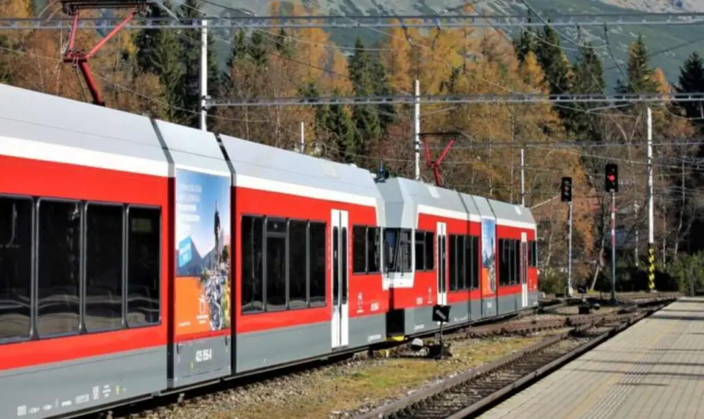
Tickets are priced at PLN 22. During peak season, it’s advisable to purchase tickets well in advance. The second leg involves switching from Stary Smokovec to a local train, known as the elektricka .
Ensure you have your ticket before boarding the train to avoid a potential fine I mentioned before. Tickets can be purchased at the ticket office, from a vending machine located in the station’s waiting room, or online. Depending on your preferred starting point, select your destination, either:
- Popradske Pleso
- Strbske Pleso
It’s important to note that there are no ticket vendors or machines at the Popradske Pleso station for your return journey. It’s therefore a good idea to buy tickets in advance or via phone (the station has mobile coverage).
- Strama – timetable + tickets – here
- Elektrichka – online tickets – here
- Search engine for connections in Slovakia – here
If you’re driving, the journey from Zakopane takes approximately 1h 20 minutes. Both Štrbské Pleso and Popradzkie pond offer parking at a rate of €10 per day . If you arrive early, you can settle the parking fee upon your return from the trail.
The Easiest Trail to Rysy Peak
Time: 8h 40 min, Distance: 18.9 km, Elevation: 1409 m
As a starting point, you have three options to consider. All three paths eventually converge after about 1.5 hours of trekking at Popradskie Lake. You can kick-start your journey on the blue trail at the Popradske Pleso station ( note – the station operates on request ). At the outset, a gentle 4 km asphalt path welcomes you. This path is utilized for transporting supplies to the shelter and also doubles as a cycle path.
Alternatively, if you arrive at the next station, Strbske Pleso , you’ll need to navigate a bit off the trail, heading towards the mountains for about fifteen minutes. This isn’t a challenging task. After crossing a distinctive viaduct, you’ll encounter a fork with red trails – take a right here.
Later, the green trail, which serves as a winter variant of the red trail, diverges from the main path but leads to the same destination. The red trail is closed in winter due to potential avalanche risks in the area.
I strongly recommend choosing the red trail here . All three route options present similar levels of difficulty, which is to say, none. Personally, we lean towards the first option as it is the shortest, leaving the other two for another time, perhaps when trekking to Koprowy Wierch .
Crossroads Above Poprad Pond To Shelter
Time: 2h 35 min, Distance: 4.5 km, Elevation: 816 m
From the crossroads, it’s a mere 5-minute walk to the hostel at Popradskie Pond . It’s certainly worth a visit, but preferably on your return from the peak. Now, the mountains beckon! The breathtakingly beautiful Mięguszowiecka Valley awaits.
In the morning, you’ll find prepared packages at the crossroads. These are supplies for the Rysy Shelter, carried up by hikers themselves. A hot cup of tea awaits them at the shelter.
After about 30 minutes, you’ll cross a bridge over Żabi Potok and immediately come to a trail fork. Turn left for Hińczowe Stawy and Koprowy Wierch, or right for Rysy. As you walk, you’ll be treated to the magnificent vista of the Baszt ridge (to your left), with the towering Mięguszowiecki Wołowiec straight ahead.
From here, the slope gradually steepens. You’ll first traverse dwarf mountain pine, winding trails, and then the landscape takes a much more dramatic turn. The Mięguszowieckie, Small and Great Ponds in Żabie look absolutely stunning.
Chains on the Trail to Rysy from the Slovak side
Under favorable conditions, the most challenging segment of the Rysy trail from the Slovak side poses no difficulties . However, things may be quite different with slippery rocks and ice. Nevertheless, we have mixed feelings about this.
It appears to us that the profusion and concentration of iron disrupt the aesthetics, leaving an unsightly impression and detracting from the natural harmony of the Tatra Mountains’ beauty. It seems these instalations were primarily designed for carriers delivering supplies to the shelter. Regardless, this is the only notably difficult spot on the route, beyond which you’ll need to simply maintain your stamina.
From Rysy Shelter To Rysy Peak
Time: 45 min, Distance: 0.8 km, Elevation: 258 m
As the trail passes through a Himalayan-style gateway, you enter a landscape of unparalleled beauty. Just before this, a plaque mounted on a rock welcomes you to the Free Kingdom of Rysy . Chata pod Rysami is a seasonal refuge open in the summer from June 16 to October 31.
The accommodation is somewhat limited, offering only a handful of spaces. Also, the network coverage isn’t particularly good, so it’s best to text the shelter for reservation purposes.
Staying here costs around €24 at weekends , and a few euros less during the week. The shelter has faced the wrath of avalanches on several occasions throughout its history, with the last renovation carried out in 2012.
The peak is just 45 minutes from the shelter , and while the trail is no longer technically challenging, it still offers captivating views. The scenery becomes particularly stunning from the pass—brrr ah! Below is Dolina Ciężka , Ganek and the renowned Galeria Gankowa , and then the magnificent Gerlach itself. After crossing the ridge, the view opens up to the Polish side with Mięguszami in the foreground!
And then it’s the final stretch to the peak, albeit a narrow one, so tread carefully to avoid slipping. Rysy comprises three peaks. The border peak stands at 2499 m, but in Slovakia, there’s an even higher peak at 2500 m, and the third, ranking last in hierarchy, stands at 2473 m.
Practical Information for the Slovak Side
– The trail is closed during winter – Don’t forget to get insurance – Entry to the TANAP region is free – Parking costs €10 per day – The Rysy trail from the Slovak side is much simpler than the one from Morskie Oko – Before setting off for the mountains, ensure you’ve checked the return public transport options
References:
- https://pl.wikipedia.org/wiki/Rysy
- https://idos.idnes.cz/
- https://pl.wikipedia.org/wiki/Ni%C5%BCnie_Rysy
- https://www.zakopane.pl/strefa-turystyczna/turystyka/wycieczki-gorskie-latem/szlaki-lato/rysy/
- https://kgp.info.pl/wykaz-szczytow/rysy/
- https://topr.pl/
You May Also Like:
The Majestic Gerlach – A Guide to Conquering the Tatra Mountains’ Peak
The Valley of Five Polish Ponds – Your Guide Through Trails and History
Tatra Mountains – An Insider’s Guide to All Attractions and Info

- Tatra Hiking Map
- Cheatsheets
- Buy me a coffee! ☕️
Hiking to Rysy peak - the highest mountain in Poland

By Joanna (Contact Me)
Mountain hiking Sept. 18, 2023 Poland Tatra Mountains Zakopane High Tatras 2023 Mountain hiking
Tatra mountains are the highest Polish mountain range and many outdoor enthusiasts consider Tatras the best place for hiking in Poland. I think that those mountains are one of the best places to hike in Europe.🧡
If you would like to stay close to this amazing region, have a look at the list of the most beautiful Tatra Mountains resorts .
The majority of hikers who visit the Tatra Mountains want to climb Rysy peak. There are many reasons for this:
- It’s the highest mountain in Poland (2499m).
- It’s beautiful.
- It's considered to be one of the best hikes in Poland .
- So many other hikers have already climbed it.
- The trail starts at the most popular place in Tatra mountains - Morskie Oko lake .
However, it’s good to gather some information about this trail before we set off.
In this article you gain following knowledge
Don't miss other valuable tatra mountains articles.
Make sure you read all helpful articles. You find them grouped them into three categories, Basic, Routes & Maps and Advanced.
- Basics of Tatras
- Slovakia vs. Poland
- You Need a Map
- Hiking Video Clips
- Slovakia Hiking Routes
- Poland Hiking Routes
- Magnificent Lakes!
- Rysy mountain
- All About Zakopane
- Before You Go Hiking
- How to Avoid Mistakes
- Find Accommodation
- About Hiking in Tatras
- About Tatra National Park
- 5 day-hikes in Tatras
- Most Popular Mountain
- City & Mountains
- About Western Tatras
- Tatras Forum
- Download free Tatra Cheatsheet
- View selection of Tatra hotels in Poland or Slovakia on booking.com
Is it difficult to climb Rysy?

True, Rysy is one of the most exciting hiking trails in High Tatras, but a lot of caution is needed during the hike.
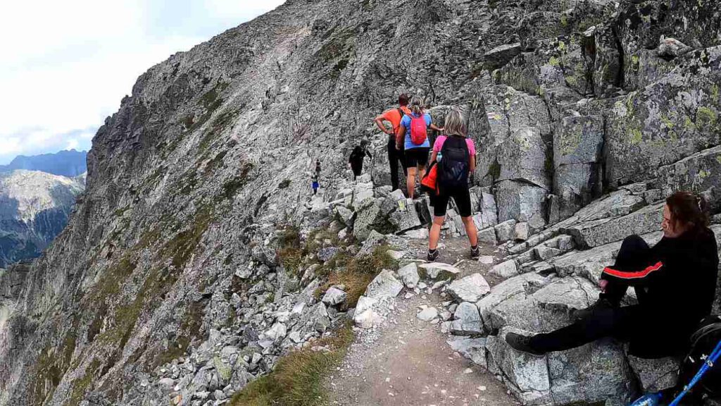
Unfortunately, many hikers decide to climb Rysy peak without any preparation or knowledge about the trail. It often results in stressful situations. Best-case scenarios are panic attacks, stress and traffic jams on the trail .
Example of a traffic jam near the Rysy peak (in September):

If we decide to hike to Rysy, we need to be aware of a few threats:
- Good physical condition is necessary.
- Rysy is not recommended as the first mountain you ever climbed.
- Rysy trail is well secured, that’s true, but if we don’t have experience in high mountains, it may just turn out to be too difficult.
- The trail is crowded. It not only decreases pleasure from admiring breathtaking mountain landscapes, but it also makes climbing harder.
- The trail leading to Rysy peak is located in high mountains, which means: 1) There can be snow even in the summer - slipping is one of the leading causes of accidents in Tatra mountains. 2) Weather in higher parts of the mountains may differ significantly from the conditions near Morskie Oko lake. 3) Weather can change abruptly during our hike. It’s extremely dangerous to be high in the mountains during a storm with bolts of lightning. It’s easy to lose the trail when it’s foggy. The trail itself is steep and stony.
I know it all looks like I want to discourage everybody from climbing Rysy, but actually, I wish to emphasize the fact that this trail requires good physical condition and high mountain hiking skills . It’s definitely not suitable for people with a fear of heights.
Before setting off to Rysy mountain, make sure you avoid these frequent mistakes made by hikers .
Trailhead in Polish Tatras

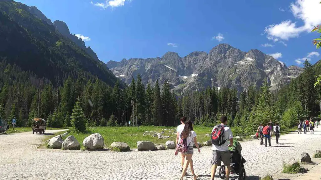
Rysy trail starts in Palenica Białczańska in Zakopane. It's also called Morskie Oko parking. It’s open 24/7.
It's the trailhead to some of the most beautiful hikes in High Tatras (including the famous Valley of The Five Lakes).
Morskie Oko parking is extremely popular - when we got there before 7 AM it was already half full. he parking is massive but it's not enough to handle the enormous traffic generated by High Tatras' popularity.
The earlier you leave your car there, the better.
Therefore, if you're planning to travel Poland by car and need parking, you need to reserve a parking space in Palenica Białczańska in advance . You can do this here - unfortunately, the site is in Polish only (sigh).
If you can't buy the Morskie Oko parking ticket online, you may purchase it at the Tourist Information Office in Zakopane on 44 Chałubińskiego Street (check it on Google Maps here ).
If you travel using public transportation, then you can get to Palenica Białczańska by small buses which shuttle from the bus station in Zakopane on 23 Kościuszki Street (check it on Google Maps here ). On the bus station look for a vehicle with „Łysa Polana” / „Morskie Oko” / „Palenica Białczańska” table at the front. Tickets are available for purchase only by driver, cash only.
Rysy hike - description of the trail
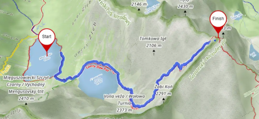
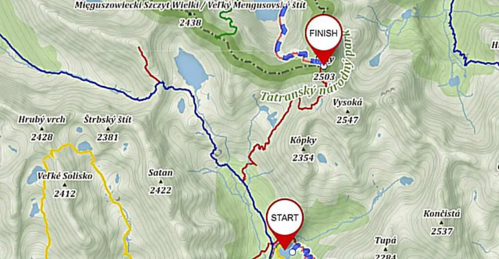
OK, now that we’re aware of the difficulties on the trail, it’s time to take a look at the route. Here's our map of the Rysy trail:

Even though there is an overview map we always recommend having a paper Tatra Mountains map .
Average hiking time: 6h 30min
Height difference: 1520m (!).
STARTING IN PALENICA BIAŁCZAŃSKA TOWARDS MORSKIE OKO MOUNTAIN HUT (red trail)
- MORSKIE OKO
- CZARNY STAW
BULA POD RYSAMI

The trail leading to Morskie Oko lake is nothing exciting. Just a long asphalt road, can make walking rather unpleasant, especially if we wear hiking boots. There are lots of people on the road, even early in the morning.
What we liked about Morskie Oko trail was thew views and the murmuur of a stream - these two factors make walking to the famous Tatra lake more pleasant.
What surprised us on our way to Morskie Oko was a wild deer which was grazing about a metre from the trail. 😮 The animal didn't give a toss about the people - it was just having breakfast and everyone was taking a photo of it.
I guess the deer is more used to crowds on the trail than I am. 😉

There's one interesting spot on this trail - Wodogrzmoty Mickiewicza (1100m). Those are picturesque waterfall cascades which make a lot of noise and are an excellent spot for taking a photo.
If you hike fast and don't take many breaks, you can get to Morskie Oko lake in less than 1.5 hours.
Near Morskie Oko lake there's a mountain hut, which offers a variety of food and drinks. But let's not stay there for too long, as we need a lot of time for our hike to Rysy.
ON THE WAY FROM MORSKIE OKO TO CZARNY STAW POD RYSAMI (red trail)

It gets better after we pass the mountain hut and follow the red trail, which turns into a classic Tatra pavement made with big stones. We get to admire amazing Morskie Oko lake and High Tatra Mountain peaks.
After about 20 minutes of relaxed walking the trail gets steep. This part is rather tiring, but the trail is technically easy to hike.

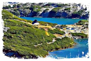
We start our climb to another picturesque lake - Czarny Staw pod Rysami (1583m). It’s surrounded by majestic soaring peaks of High Tatras. Fantastic place that is!
There's a lot of space near the lake to take awesome photos and contemplate nature's beauty.
ON THE WAY FROM CZARNY STAW POD RYSAMI TO THE BULA POD RYSAMI (red trail)

The plateau next to Czarny Staw pod Rysami is a great spot for taking a break, but we have to move on to hopefully reach the peak before it gets crowded.
We walk along the left side of the lake. This part is nice and easy. I loved that stony pavement, so typical for Tatra mountains!
After about 15 minutes we get to the bottom of a very steep trail - in 1.5 km we need to do about 900m of height difference , which gives an average slope gradient of 30 degrees. That’s a lot!
The good thing is there are no other difficulties - the path is built from big stones which create steps. It’s easy but steep and strenuous.

After about 30 minutes of climbing the surrounding changes - it becomes more challenging to hike because of stone rubble.
Word of caution, the path from now on to the Rysy peak has on average 11 accidents per year which are the highest among all in Polish Tatras and five times higher than on average path.
The path leads between big rocks and then turns left - we get to the rim of Kocioł pod Rysami (Rysy Cauldron) located on 2054m. Kocioł pod Rysami is one of the most shadowed places in Tatra mountains. There might be snow even at the beginning of summer.
Over Kocioł pod Rysami rises Bula pod Rysami. Getting there from Black Pond takes about 1.5 hours. It’s a great place to take a break - almost flat terrain invites to rest before a further climb.
When the weather is favorable, we get to admire incredible Tatra peaks: Mięguszowieckie, Wołowy Grzbiet, Żabi Koń, Tomkowe Igły, Kazalnica and Żabi Mnich.
Hike to Bula pod Rysami (2054m) should be OK even for inexperienced hikers (when the weather is nice, that is). The most challenging part starts just here.
ON THE WAY FROM BULA POD RYSAMI TO THE RYSY PEAK (red trail)

The path gets steep again. We see the first chains. Those artificial facilitations will lead us practically up to the peak.
The trail leads us along the left side of the gully. It winds a little along steep stony plates. On exposure points there are chains. It’s medium difficult, but rather tiring because of the constant gradient.
In some spots, those chains didn’t seem very useful to me, but there were also places where the iron facilitations were more than welcome. One is for sure - when the trail is slippery each one of those chains comes in handy .

The higher we hike, the better view we get to admire. Black Pond and Morskie Oko lakes together with majestic sharp peaks give a truly astounding landscape.
If I went there alone, I’d probably climb all day - I’d turn around after every step to admire one of the best views in Tatra mountains. 💙
Our ascend on stony slope ends near the gap from which runs a deep crevice. The trail turns right and leads along ledge shelf, secured with chains.
Let’s not let amazing landscape of Slovak Tatra mountains distract us because this part is highly exposed - we get to hike over a 500-metre abyss. This gap is the most difficult part of the whole trail!
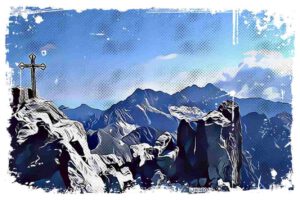
When we pass this terrifying gap we climb a rather easy ridge and get to the highest peak of Poland - Rysy (2499m).
THE RYSY PEAK

To be precise, Rysy mountain isn’t just one peak which reaches 2499m (if only school teachers knew about that!). Rysy is actually a mountain massif which consists of 3 peaks . The highest one reaches 2503m and belongs to Slovakia (together with the lowest peak which reaches 2473m).
Hard to say why this mountain massif is divided between two countries, but never mind that.
Getting to the highest peak takes merely a few minutes, so it’s worth to hike there. Technically it’s not difficult, but it’s not secured with chains. Because of the exposure , we need to pay attention to our steps.
Even though there is an overview map we always recommend to buy paper hiking map of Poland & Slovak Tatra .

One more note worth to mention is that we hiked there on Saturday at the beginning of September, and there were crowds of people at the top. I have to say that most of the time I was too busy with bypassing other hikers to have time to admire the astonishing landscape of High Tatra mountains.
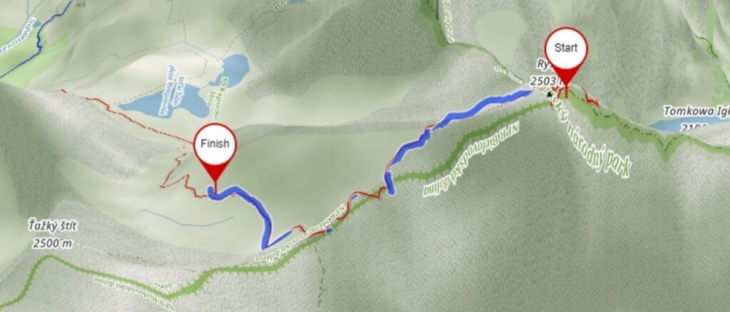
To summarise here is our entire route short description with some numbers of one-way up to the Rysy:
PALENICA BIAŁCZAŃSKA
We started from Palenica where we left our car as we enter the national park terrain car must be left. We followed the red trail which is tarmac road.
Distance : 0km (0mi)
Time : 0:00
Altitude : 984m (3228ft)
Coordinates : 49.25596,20.1016583
MORSKIE OKO LAKE
Here we took a short breath before continuing now rocky red path leading to the Rysy.
Distance : 7.9km (4.9mi)
Time : 2:20
Altitude : 1406m (4612ft)
Coordinates : 49.2032388,20.0707366
CZARNY STAW POD RYSAMI LAKE
We continue to go red trail and it is getting more steeper and more rockier.
Distance : 9.5km (5.8mi)
Time : 3:15
Altitude : 1583m (5193ft)
Coordinates : 49.190218, 20.074446
Here we were stack before reaching the peak for good 30 minutes. There is few very steep falls near by the path.
Distance : 11.6km (7.2mi)
Time : 5:20
Altitude : 2056m (6745ft)
Coordinates : 49.1815351, 20.0820637
The Rysy Peak
Finally we got to the peak having just a moment of admiration before moving back to returning way
Distance : 12.4km (7.7mi)
Time : 6:34
Altitude : 2499m (8198ft)
Coordinates : 49.255535, 20.103013
Buy paper hiking map of Poland & Slovak Tatra .
So, we’ve just climbed Rysy mountain top, and now what?
There are 2 options:
- Difficult - descend on the same trail to Morskie Oko lake.
- Easier - hike down to Štrbské Pleso or Popradské Pleso in Slovakia.
We decided to choose the easier option and climb down on Slovak trail leading to Štrbské Pleso.

Practical info
- Palenica Białczańska parking lot is very popular among tourists. It’s open 24/7, so try to get there as early as possible, as there might not be space available after 9 AM.
- Rysy mountain belongs to Tatra National Park. If you enter the Park in Poland you need to pay the entrance fee at the stands near the trailheads.
- Rescue missions in Poland are free of charge, but in Slovakia, they are paid.
- Remember to buy insurance before you go hiking in the mountains.
- Trails in Tatra mountains are marked with 5 colours: black, red, green, yellow and blue. They don’t indicate the difficulty, it's just identification.
- Hikes from Zakopane are well-marked. There are many signposts, usually placed at the beginning of a trail, on the forks, and at the end of a trail.
- Signposts show the destination and average hiking time. If we take long breaks or the weather is very unfavourable, our hike may take longer than signpost states.
- Mountain huts in Tatras are crowded, even in low season. It’s recommended to book a room/bed a few months in advance (I know, it’s not compatible with the idea of a mountain shelter, but Tatra mountains are very popular).
Mountain huts in Tatras

Here is a list of mountain refuges in Polish Tatra mountains.
We need to remember there are not many mountain huts High Tatras. The closest mountain shelter in Slovakia is Chata pod Rysmi (2250m). It is open only in the summertime from June 16th to October 31st.
→ Chata pod Rysmi tel. +421 903 181 051, +421 52 442 23 14 chatapodrysmi.com
→ Morskie Oko tel. +48 18 20 77 609, +48 602 260 757 schroniskomorskieoko.pl
→ Roztoka Valley tel. +48 18 20 77 442 schroniskoroztoka.pl
→ Five Lakes Valley tel. +48 18 20 77 607, +48 781 055 555 e-mail: [email protected] / [email protected] piecstawow.pl
→ Murowaniec tel. +48 18 20 12 633 e-mail: [email protected] murowaniec.e-tatry.pl
→ Kalatówki mountain hotel tel. +48 18 20 63 644, +48 18 20 12 827 hotel@kalatówki.pl [email protected] kalatowki.pl
→ Hala Kondratowa tel. +48 18 20 19 114 halakondratowa.pl
→ Hala Ornak (Koscieliska Valley) tel. +48 18 20 70 520 e-mail: [email protected] schronisko-ornak.pl
→ Chochołowska Valley tel. +48 18 20 70 510 chocholowska.com
Rules in Tatra National Park
- Camping in Tatra National Park is forbidden.
- The only place where we can spend the night in is mountain shelters.
- There are wild animals. If you meet one, try to retreat calmly. Don’t get too close to take a photo of the animal - it may be dangerous.
- Don’t feed the animals - they may lose their self-sufficiency.
- There are no rubbish bins in Tatra National Park - we take all our litter with us.
- From March 1st until November 30th all trails in Tatra National Park are closed at night (from dusk until dawn).
- For Tatra tourist information you can call: +48 18 20 23 300, or send an e-mail to [email protected] .
- In case of emergency:
→ in Poland call 601 100 300 or 112
→ in Slovakia, High Tatras call 0903-624-869
Tatra Mountains resorts
→ ZAKOPANE
One of our favorite places to stay in Zakopane is Toporowa Cyrhla district . It's a quiet area, close to trailheads. It's about 6 kilometres from Zakopane center, but for us, it's an advantage.
We managed to find there nice accommodation - Willa Bartek. Comfortable and clean rooms, the kitchen is very well-equipped. Billiard, table football, ping pong table.
→ MURZASICHLE
However, Zakopane tends to get crowded, especially in high season. If you're looking for a quieter place to stay close to trailheads, you might want to choose Murzasichle. It's the highest located village in Poland (but the prices are a bit lower than in Zakopane 😉).
You may check available hotels in Murzasichle here:
If you're planning on climbing down to Slovakia, you have 2 options to stay in: Šrbske Pleso or Popradske Pleso.
→ ŠTRBSKE PLESO
A popular Slovak mountain resort located over a picturesque lake in High Tatras. Štrbské Pleso is amazingly beautiful and I think it's one of the best places to visit in Tatra mountains.
There are many places to stay in, but lots of travelers consider Hotel Panorama Štrbské Pleso as one of the best hotels in High Tatras.
You may check the prices here:
→ POPRADSKE PLESO
If you prefer to stay near Popradské Pleso lake, there is just one option - Horsky Hotel Popradske Pleso . It's located deep in the forest right over a beautiful mountain lake. Some people say it's a comfortable hotel, some consider it a mountain hut, but for me, it's just one of the best hotels in High Tatras 🙂.
You can check it here:
Tips to climb Rysy successfully
- The best time for climbing Rysy mountain is September. There are just too many tourists in the summer. Besides, the weather is more stable than in July or August (low chance of storms in September), and there’s still a low probability of snow.
- The best days for Rysy hike are weekdays. Avoid going there on weekends - you will get stuck in traffic as we did.
- It's better to climb from Morskie Oko lake and descend on the Slovak side. I'd not enjoy climbing down on the Polish trail.
- Don’t count entirely on your mobile phone - take a paper map with you .
- Get yourself a comfortable backpack which will make the hike easier.
- Don’t hesitate to retreat if the weather gets bad or you don’t feel very well.
- Weather in Tatra mountains is unpredictable - remember about good hiking boots, warm clothes and waterproof accessories.
- Try to start hiking as early in the morning as possible (weather before noon is usually more stable).
- Make sure you have the complete hiking gear necessary to explore high mountains.
- If you want to climb Rysy peak, but don’t have experience in high mountains, hike a lot, increase your skills, and graduate the difficulty of the trails. If you don’t have much time to gain experience, you can climb the mountain from the Slovak side, although keep in mind that this trail is also long and strenuous.
- Check the High Tatras weather forecast before you go into the mountains. Here are some useful websites where you can check actual weather conditions in Tatra mountains:
→ meteoblue.com
→ accuweather.com
→ mountain-forecast.com
Rysy hike - is it worth it?
Some people say that the trail leading to Rysy mountain is overrated, and that hiking there isn't outstanding, because of the crowds of tourists climbing it. To make matters worse, a lot of those tourists are unprepared and not aware of the difficulties on the trail.
However, this doesn’t change the fact that Rysy remains the highest mountain in Poland, and the panorama from this peak is the most beautiful in this part of Europe. Well, not only the panorama - the whole Rysy trail is stunning as is all the region of High Tatras.
Here is a short video presenting our Rysy summit hike:
Day trips from Zakopane
If you would like to take a break from hiking and try other things to do in Tatra mountains, you might be interested in the below options:
→ CHOCHOLOW THERMAL BATHS
The biggest waterpark in southern Poland. Opened in 2016, it offers numerous indoor and outdoor pools with hot thermal water (there are about 30 of them!), many different kinds of saunas, slides, kids zone, SPA facilities, sports centre, restaurants and pool bar.
We especially liked the spacious infrared sauna with big windows from which we admired the panoramic view on Tatra mountains.
If you would like to visit this modern water park and not wasting time in lines, you can get a full access ticket in advance here:
Visit the biggest waterpark in southern Poland and treat yourself to the therapeutic hot springs water and saunas
→ BIALKA TATRZANSKA THERMAL BATHS
It's a smaller waterpark than Chocholow Thermal Baths but also a fun place to visit. It offers a few thermal water pools with a beautiful mountain view and several saunas, outdoor. Bialka Tatrzanska Thermal Baths are divided into the quiet and loud zone. The latter one offers water attractions: waterslides, kids fun zone, outdoor pools, waterfalls, etc.
You can get a skip-the-line ticket along with hotel pick-up here:
Relax in hot springs water while admiring beautiful mountain view. Hotel transfer is included
→ CASTLES IN SLOVAKIA
Slovakia is famous for its medieval castles. One of the most impressive Slovak fortresses is the Bojnice castle. This fairytale-like castle was built in the 12th century and is visited by travellers from all over the world.
If you would like to visit this castle, you can book a tour with a professional guide and hotel pick-up. This day trip includes also visit in Bojnice castle gardens and zoo, and Beckov castle ruins.
Get o know Slovak historical heritage and discover the most beautiful castles in the country. A knowledgeable guide will get you familiar with Slovakia's history and architecture. Pick-up and drop-off included
Other stunning hikes in High Tatras

If you'd like to explore other hiking trails in High Tatras, check out the below posts:
⛰️ Kriváň - national mountain of Slovakia
⛰️ The most beautiful hikes in High Tatras
⛰️ Kościelec mountain in Polish Tatras
⛰️ Szpiglasowy Wierch mountain in Polish Tatras
⛰️ 6 easy High Tatras hiking trails
⛰️ Štrbské Pleso - Popradské pleso hike
⛰️ Bystrá lávka - exciting trail in High Tatras Slovakia

How this blog is organized?
Subscribe for free tatra cheatsheet pdf.

12 attractions of Poland you need to see

10 best day trips from Kraków

17 most beautiful lakes in Europe

12 best nature places to visit in Poland

The most spectacular High Tatras hiking trails

The most beautiful trails in Anaga mountains - hiking Tenerife
Interesting

Zakopane travel guide for hikers and travelers

One of the best hiking trails in High Tatras near Strbske Pleso
19 most beautiful natural wonders - best destinations in Europe
3 reasons why we need to stay close to nature
Mountains in Poland - overview
Review of Sony FDR-X1000v camera for normal people
Hiking in Poland - practical information
Tatra mountains – one of the best places to hike in Europe
9 best places to visit in Southern Poland
Annecy - attractions in the French Venice
14 reasons why travelling with others is better than solo travel
For adrenaline junkies – via ferrata trails in Austrian Alps
6 most famous hikes in Tatra Mountains
5 things which make Italy the best country for skiing
Hiking in Teide National Park - Chinyero Volcano trail
The North Face Gore-Tex shoe gaiters
Hiking map of Tatras
1-Day Trek to Rysy from the Polish Side

Let UIMLA-certified mountain leader Marcel take you on an epic day hike up the Polish side of Rysy in the High Tatras mountain range.
Description
Let me take you to the highest point of Poland on this day-trek to Rysy in the High Tatras! Hike through some of the most picturesque mountain scenery on your way to the summit on the border of Slovakia and Poland.
Rysy is located in the main ridge of the High Tatras mountain range, right on the border of Slovakia and Poland. At 2,499 meters, Rysy claims the tallest peak of Poland, and even has an additional peak on the Slovak side.
It is a popular hike for adventurers and travelers, and during the summer offers multiple paths to get to the summit that vary in time and difficulty. Being surrounded by the lakes and wildlife as you climb makes this a once-in-a-lifetime experience.
And of course, the views from the summit expose the immense beauty of two countries – you couldn´t ask for a better vantage point.
Our program will start in Palenica Bialczanska at 1,000 meters. We will travel up to the largest lake in the High Tatras, Morskie Oko, and on to the second-deepest lake, Black Lake. The scenery around the lakes will give you a rare chance to explore the remote nature of Poland first hand.
The next leg of our ascent is a technically difficult hike, and will include a long section of path that is aided by chains. The reward for our hard work is reaching the summit of Rysy and its unparalleled panoramas, making the climb all the more satisfying.
After a small rest at the peak, we can choose to return to Palenica Bialczanska using the way we came, with a break at a mountain hut by Morskie Oko. Or we can also choose to hike down the Slovak path through Popradske Pleso to Strbske Pleso to experience both sides of the mountain.
This is a difficult hike, spanning 10-12 hours of trekking. You should be an experienced hiker and be in great physical shape.
Book now and spend your day on an unforgettable trek to the top of Rysy – one of Poland´s most incredible adventures!
I can also take you on a program to ascend Rysy from the Slovak side ! Or I can take you on a day trek to one the best spots in the High Tatras – Krivan !
Price includes
- Guiding fee
Price details
Price does NOT include transportation to/from the starting point, nor does it include your required mountain insurace. If applicable, it does NOT include the price of the horse carriage ticket.
Day 1 : Hike to Rysy
We will begin at Palenica Bialczanska at 1,000 meters. Here you may choose the optional horse carriage up to Morskie Oko.
We will travel up to the largest lake in the High Tatras, Morskie Oko (1,400m), and on to the second-deepest lake, Black Lake.
Our ascent increases in difficulty as we climb to the summit. It includes a long section of path that is aided by chains. Once we reach the summit of Rysy (2,499m), we will have a small rest.
We may choose a descent back to Palenica Bialczanska and stop by a mountain hut near Morskie Oko. Or we may choose to descend via the Slovak side of the mountain and climb down to Strbske Pleso (1,350m).
You have an optional horse carriage that will take you to Morskie Oko. This is not included in the price.
You will need to purchase mountain insurance for Slovakian Mountain Rescue Services. Any international mountain insurance will suffice.
Meeting point
I’ll be in Krakow, how can I come to the starting point of the hike?
The best is to be in Zakopane the day before the hike. The best way coming from Kraków is to take a train from the airport to the bus station and then take a bus to Zakopane.
I’ll pick you up at your accommodation to Zakopane, and we’ll drive together to the starting point of the hike (1-hour drive).
I can also help you organize a private transfer from Kraków if you wish.
How long is the hike?
The hikes (up and down Rysy) from & to the starting point, takes around 12 hours.
How experience do I need to be? How difficult is the hike?
You should be an experienced hiker and be in great physical shape. It’s a 10 to 12-hour hike. This route is technically and physically demanding. We can also hike up Rysy from Slovakia, the route is easier.
What’s include in the price of this hiking tour?
My guiding service is included in the price of this tour.
The following items are not included:
- Transportation from the starting point of the hike (and back)
- The mountain rescue insurance (I can arrange it for you if you don't have any)
- The horse carriage to Morskie Oko (optional)
I'm alone, is it possible to join a group?
It is not possible to join a group. I only organize private tours to Rysy. It is the best option because you can hike at your own path without feeling pressured by the other members of the group.
Is it also possible to hike up to Rysy from Slovakia?
Yes, it’s possible to make it from Slovakia. The starting point is at the border, in Lysa Polana. The hike from there is easier than from the Polish side.
How many hikers can you take with you?
For safety reasons, I’ll take maximum 7 hikers with me. It would be less if the conditions in the mountains are challenging. If you are with a larger group, I’ll ask one of my colleagues to join us.
Do I need a mountain rescue insurance?
You need to have an insurance covering the evacuation from the mountains. If you don’t have any, I can buy it for you here. It is around €1/day, and it covers the transport or evacuation from the mountain to the hospital. It is not covering the medical assistance & services.
What equipment do I need to take with me?
Here is a list of equipment to have with you:
- hiking boots that provide ankle support
- warm socks suitable for hiking
- a shirt or t-shirt
- a breathable trouser
- a wind stopper & waterproof jacket
- a cap or a buff
- a pair of gloves
- a small backpack for the day
- your personal medication (if you need/take any)
- sun cream and sunglasses
- your personal first aid kit
- water bottle (minimum 2 liters)
- some snacks
- your cell phone (for emergency calls)
When is the best period to climb up to Rysy?
The best time to climb Rysy is from mid of June till end of October.
Are you offering other outdoor/adventure guided tours in & around the Tatras?
I'm offering several other guided tours, during the summer & winter. You'll find them here https://www.explore-share.com/mountain-guide/marcel-kubinsky/
What are some recommended accommodations near our adventure location?
About the guide

Mountain Leader
I'm a UIMLA mountain leader and national tourist guide (for cultural and historical heritage trips).
I was born in Poprad in 1969. From my early childhood, I often looked out my bedroom window into the distance of the picturesque High Tatras, which fascinated me even then. In high school I started going with my friends to a small climbing "expedition" on the surrounding rocks, and later to the High Tatras. Mostly I went with a friend whose father was a member of the Mountain Rescue Service. During my studies at Comenius University in Bratislava, I loved coming back to the mountains. In 1999 I started actively volunteering paramedic of the Tatra Mountain Rescue Service, and then I was hired there. Precisely because of my relationship with the mountains I began working as a tourist guide with a focus on mountain areas. Since 1998 I accompany tourists from around the world to the mountains and surrounding towns. In 2011 I got certified as mountain leader. Besides, I have been working as a member of the Council of the Slovak Association of mountain Leaders since it was established in 2011.
Slovak | Polish | English
Certificates
What people are saying about this trip
Great service and very knowledgable; also an excellent motivator!
The hike was much more difficult than I was prepared for but it was worth every view! Marcel is a very experienced guide and very patient, and has a lot of knowledge about the Tatras mountains and surrounding regions. I would recommend Marcel to anyone who is looking for a guided trek or tour in the Tatras / Carpathian ranges, either in Poland or Slovakia :) P.S. Hiking poles are good to have while descending from Rysy peak. Thank you very much!
Marcel and Ondrej were fantastic- incredibly friendly helpful and supportive- another fantastic hook up courtesy of Explore-Share. Definitely endorse this platform and the super high calibre guides they recruit.
A wonderful trip, trek & experience with Explore-Share mainly due to Marcel our guide, the/his service & communications ahead of our overseas travel were second to none. Marcel provided us with confidence during the tough day & his knowledge & background history/stories associated to the area, changing of borders, etc made our day very interesting & rewarding. I would certainly recommend Explore-Share with Marcel’s services to anyone who is looking to summit Mt. Rysy, very professional & reassuring during the trek. Thanks Marcel, your company & guiding was exceptional making our trip so memorable, top man 🏔️👌🏽
Marcel has a professional but friendly approach to hiking. His love of hiking, climbing, Slovakia, history, and of course the mountains is obvious and contagious. I would recommend him to anyone from beginner or advanced outdoor person.
You may also like

5-day Hiking tour in the Polish Tatras

Rysy Summit, High Tatras, Slovakia, Guided Trek

High Tatras Summer Hiking in Poland and Slovakia

1-Day Trek to Rysy from the Slovak Side

Hiking to the top of Giewont (1,894m) in the Tatra Mountains, from Zakopane, Poland

Hiking from Krakow to High Tatras in Slovakia

Poland Snowshoeing Course in the Carpathian Mountains

Zakopane, Poland, 2 Day Guided Hiking Tour

6-day Hut-to-hut trek in the Polish Tatras
Find more trips
Join our newsletter.
Stay up-to-date on the best adventures.

Top ways to experience nearby attractions
Most Recent: Reviews ordered by most recent publish date in descending order.
Detailed Reviews: Reviews ordered by recency and descriptiveness of user-identified themes such as waiting time, length of visit, general tips, and location information.
Also popular with travellers
Rysy - All You Need to Know BEFORE You Go (2024)
- (6.48 km) Grand Hotel Kempinski High Tatras
- (15.62 km) Willa Dewajtis
- (15.49 km) Wellness Penzion Strachan
- (14.59 km) Kontakt Wellness Hotel
- (13.25 km) Grand Hotel Permon
- (10.52 km) Starý Šmakovec Restaurant
- (15.98 km) Casa Mia Restaurant
- (6.52 km) Furkotka
- (10.63 km) Spitz Restaurant and Bar
- (14.94 km) La Playa Beach Bar & Chillout Lounge
The Ultimate Guide to Hiking Rysy Mountain
Standing at 2499 metres, Rysy Mountain is the tallest mountain in Poland. Located in the High Tatras, Rysy actually straddles the border between Poland and Slovakia and can be hiked in either direction.
We were visiting Poland for a week when we hiked Rysy. We were staying in the beautiful mountain town Zakopane , two hours from Krakow . If you’re short on time, this hike can also be done in a day from Krakow , as long as you leave very early!
Read: 11 Best Things to do in Krakow
Rysy Mountain is one of the most beautiful hikes in the High Tatras, rewarding you with breathtaking mountain views, shimmering alpine lakes and a great challenge!
It’s also the tallest peak in the Tatras you’re able to climb without a guide and therefore makes it very popular.
In this ultimate guide to hiking Rysy Mountain, we’re going to split it up into sections that naturally break up the hike as well.
The first section is the hike to the stunning Morskie Oko lake. Then the hike up to Czarny Staw and finally Rysy peak. We’ll end the guide with everything else you need to know.
No time to read this post on hiking Rysy Mountain now? Save it for later!

MORSKIE OKO
The trail to Morskie Oko isn’t the most exciting; a flat paved road full of people and horses and carts carrying people that don’t want to walk. We’d recommend getting a good pace on here. If you do, you can get to Morskie Oko in about an hour and a half.
Leave early! We left Zakopane at 7am and there were still quite a few people on the trail. We picked up our pace, passed the crowds walking in heels and flip flops (yes, really!) and managed to beat most people to the lake.
Morskie Oko is absolutely beautiful! Its crystal clear waters lie peacefully at the bottom of dramatic mountain peaks. It’s the largest lake in the Tatra Mountains and is located at 1395 metres above sea level.

There’s also a mountain hostel with a large outdoor seating area on the shores of the lake, perfect for a beer on your way back!
Our Top Tip: please please please don’t use the horses and carts! Quite a few are known to die on this route as they’re worked too hard!
Read: Ultimate Guide to Hiking the Stunning Seven Rila Lakes
Czarny staw.

Czarny Staw is about 45 minutes on from Morskie Oko and this is where the views become something really special. Turn around and admire the incredible viewpoint over Morskie Oko, the High Tatra peaks and the whole valley.

Czarny Staw literally means “Black Pond” and lies at an altitude of 1583 metres. Again, this lake is surrounded by dramatic soaring peaks.

Our Top Tip: this is a great spot for your first proper break. Most people stop at Morskie Oko for the day so this lake is never as busy. Also, if you left early, you should be one of the only people here.
Read: 8 Best Things to do in Zakopane: Complete Guide
Rysy mountain peak.
After about an hour and a half, you’ll reach a huge rock offering you an incredible view of Morskie Oko and Czarny Staw. This is the best place for a break before the final stretch. You’re going to need some energy!

The path is now very steep to the top, which will take about an hour and a half. The large stones have been replaced with loose stone rubble which is quite slippery.
There are chains now and again which are helpful as some parts are completely exposed with large drops below.

When you’re at a safe place, turn around to look at the view. Just wow…

Rysy Mountain actually has three peaks. They’re very close together and from the first one you need to cross a narrow rock bridge to get to the others.
We stayed at the first peak as it was incredibly windy and didn’t feel safe going over this exposed bridge with no chains. There was also a queue of people waiting on the bridge in either direction with sheer drops either side of them – no thank you.
Surrounding you are majestic sharp peaks with the turquoise waters of Morskie Oko and Czarny Staw below.

We sat for a short while appreciating the magnificence of where we were then made our way back down. Remember to stop at the Morskie Oko hut for a well-deserved beer!
To Know Before You Go
How long is the hike, how do i get there, find a hotel in zakopane.
You can also hike Rysy Mountain in a day from Krakow . If you decide to do this, we’d 100% recommend hiring a car rather than taking the bus to Zakopane and then a shuttle as you won’t start the hike until late and it’ll be very busy. Hire a car and leave Krakow no later than 6am to get to the trailhead at 8am.
Find a hotel in Krakow
Read: 5 reasons you need to visit krakow, what should i wear.
Take layers! The weather in the mountains can be very unpredictable and change at any moment. The peak of Rysy Mountain is also very exposed with high winds.
Do I need hiking experience?
The peak can get exceptionally busy as you can also hike Rysy from Slovakia. Quite a few people hike up the Slovakian side, as it’s supposed to be easier, and down the Polish side. This results in lots of people going in different directions as you’re nearing the summit.
Unfortunately, we found some people had no care in the world for anyone but themselves and just come barging down, waiting for no one, sending loose rocks flying. You really need your wits about you here!
We hope this guide to hiking Rysy Mountain has been helpful for you. It was an incredible hike and the views were definitely worth the difficulty!
Feel free to check out our page dedicated to hiking guides and trips for more inspiration or contact us if you have any questions 🙂
1 thought on “The Ultimate Guide to Hiking Rysy Mountain”
Pingback: Mountains of Europe: A Summit Odyssey Through Breathtaking Peaks - ETIAS UK
Leave a Comment Cancel Reply
Your email address will not be published. Required fields are marked *
Save my name, email, and website in this browser for the next time I comment.
- Travel and Squeak
Privacy Overview
- Route Finder
- Route Planner
- Travel Guide
- Places to visit
- Eat & drink
- Accommodation
- Ski resorts
- Current Conditions
- Avalanche Report
- Collections
- Travel Stories
- Publications
Summit tour to the Rysy (Tengerszem-csúcs, 2499 m)

Track types
Coordinates, similar routes nearby.
- Summit tour to the Kôprovský štít (Kapor-csúcs,2363 m)
- Ostrva and Batizovské pleso
- Summit tour to Ostrva (1984 m) from Strbské Pleso
- Round tour to the Bystré sedlo (Lorenz-hágó, 2314 m)
Questions and answers
Would you like to ask the author a question?
Ratings and reviews
Help others by being the first to add a review

Photos from others
Weather at the route's trailhead.
- Show images Hide images
- Snow Depth Unlock with Pro+
Excursions and leisure tips for the region
Create an account
Start your adventure today.
Already a member? Login

The Mount Rysy Hike is one of the most popular and beautiful hikes in the High Tatras, awarding you with stunning mountain views, beautiful tarns, and a great challenge along the trail. Rysy is the highest mountain in Poland and the seventh highest mountain in Slovakia. It’s also the highest peak in the Tatras you can climb without a guide, which is the reason it’s so popular among the local and foreign hikers.
Download the 10Adventures App
View mount rysy on map.
- Map Data: © OpenStreetMap
- Tiles: © CyclOSM
Quick Navigation
- View Images
- Route Description
- Insider Hints
- Getting There
Route Information
- Elevation Graph
Weather Forecast
Join our newsletter.
Get a weekly dose of discounts and inspiration for adventure lovers
Route Description for Mount Rysy
The Mount Rysi hike is marked as strenuous and with good reason. Hikers must be ready for a challenging hike including some exposed parts with chains and big crowds on top of the mountain (as the peak can be reached from both Slovakian and Polish sides of Tatras). The trail opens up on the 15th of June but the snow on the top part of the trail stays until mid-July so it is advised to either pick later in the summer or be very careful. Good hiking shoes are a must and having trekking poles is strongly advised. Also, we would recommend starting this hike as early as possible, not only because the parking fills up very quickly, but also because quite often after midday the mountain gets covered by fog or cloud. Rain on top of Rysy is not uncommon even after the sunniest mornings.
The Rysy Peak Hike is probably the most famous trail in the High Tatras. It is the seventh highest peak in Slovakia and the highest peak you can hike in The High Tatras without a guide. Rysy has three summits and is on the border between Slovakia and Poland. It’s also the highest peak in Poland. So naturally, there are a lot of people who want to challenge this mountain. It also comes with spectacular views.
The hike on the Slovakian side starts either from Štrbské Pleso or Popradské Pleso. We recommend going from Popradské Pleso, as the hike is a little bit shorter this way and the trail from Popradské Pleso starts with a well-paved path which makes it easier for your knees, savingyou some much needed strength that will help you further up the mountain. The hike starts via the blue trail with a nice ascent. You start going up through a beautiful forest. The views of the surrounding mountains are amazing and also different, which we love about this national park. This route is also accessible by vehicles that are used to transfer supplies to the Popradské Chalet , so sometimes a car might try to pass by.
You will reach the first crossroad where you can choose to follow the blue trail which will lead you faster to the peak or the yellow one, which will take you closer by the Popradské Lake. We suggest taking the blue one to get to the peak faster as with time the crowds increase dramatically on this trail.
After about an hour and 20 minutes, you will reach another crossroad where you will see a shed and some people resting. This part is a big crossroad between quite a few points. The yellow trail leads down to the Popradské Pleso and the chalet , where a lot of families come to relax by the beautiful mountain lake. The blue trail continues to Koprovsky Peak, but it is also the first part of the trail towards the Rysy Mountain Chalet and Mt Rysy peak itself. Continuing on the blue trail, you will soon find yourself immersed in the forest. The nice paved path here becomes covered in rocks and tree roots. This is a really enjoyable part and it’s full of amazing views of Mengusovka Valley surrounded by a wall of mountains, one of which is Mt Rysy.
After 30-40 minutes of hiking, you will reach another crossroad. From here, follow the red trail towards Rysy. Now you will start ascending a lot more intensely and the trail becomes more difficult. Here, you will pass a nice stream and cross a wooden bridge, before climbing a series of switchbacks up the mountain. The views along this part of the trail are magnificent.
After quite a bit of ascending, you will reach another valley with two beautiful tarns, guarded by the mountains. Walk the trail and keep the tarns on your left. Be careful here as parts of the trail were still covered in snow during July, so it gets quite slippery with summer footwear. Continue ascending towards the mountain wall.
When you reach the mountain wall, you will need to use the chains and ladders to climb up. This is another difficult part of the trail but it is manageable. Just hold on to the chains and climb your way up. This part shows why it’s important to start early as later during the day there might be people queuing here to go up or down. Make your way through the metal steps, and ascend further up. After a while the trail becomes wider and less dangerous. Just before the Chalet under The Rysy Mountain , there is usually a patch of snow. It’s really easy to go up, but might be a bit dangerous and more difficult to descend. Be careful as it is really slippery with the melting snow.
You can get some refreshments or hot drinks at the chalet, but we would suggest doing that on the return, to avoid crowds. If you need to, use the toilet on the mountain ridge which is a 2-minute ascent from the chalet. It has amazing views with a see-through plastic wall down the abyss.
A lot of people finish at the chalet, but the trail continues to Mount Rysy peak, just behind it. The ascent starts with two big patches of snow. Be careful here as you need to share the trail with those who are returning and it’s a bit too long to wait for others to pass. So try not to fall as you do not know what the snow covers. Usually, in these mountains, it might be a crack between rocks.
After the ascent, you will come up to a ridge. Enjoy the beautiful views down at Bielovodska Valley. From here you will see the highest peak in the region – Gerlachovsky Peak, Bradavica Mountain, and other sights you will see only from a few places in the High Tatras.
The Rysy summit is on your left, but it’s not the first peak you will see. The trail will become harder, as the climb gets quite steep and you start to ascend the false summit. After you climb the first peak, you will see the Rysy summit. It actually has three summits but the highest two are usually packed with people taking a break on them. Be very careful on this part as it descends to a ridge from where you start scrambling with your legs and arms up the last bit of Mt Rysy. It’s very important to follow the trail, as a lot of parts might seem like they are approachable but in the end, you might end up climbing up somewhere you cannot go anywhere from. So save your energy by following the red trail marks.
After you reach the summit, or both of the highest ones (one of them is in Poland, the other in Slovakia), enjoy the 360-degree views. Have a rest and carefully descend back the trail you came from. Depending on the time you started, you might have to let a lot of people pass through, as it’s a very popular hike and the traffic here is quite high. Some people start scrambling down through random parts of the mountain, but we strongly suggest climbing the way you came from.
After that, descend towards the chalet. Be careful along the snowy parts, as summer hiking footwear might be slippery on the snow and a lot of people fall here. The hardest snowy patch is just after the chalet, as it is quite steep and you might have to slide down. There might be an alternative trail on your left on the snow, but if it’s the end of June, be careful when using it as the snow usually melts from below, leaving a good one-meter gap between the rocky ground and the layer of snow. You might fall through and injure yourself.
The chain part might be more crowded and you might have to wait for someone to let you pass. After the chain part, the hike becomes more relaxing, although still tough due to the rocks you need to jump on all the time you are descending. Enjoy the beautiful views going down.
Trail highlights
Situated on the border of Poland and Slovakia in the High Tatras, Rysy is a rugged mountain peak with three rocky summits of varying heights. The northwestern summit ( 2,500 m ) is a part of the Crown of Polish Mountains and is actually the highest point in that country, while the middle ( 2,501 m ) and south-eastern ( 2,473 m ) summits are both located on the Slovak side of the border.
The first documented ascent of the peak was made by Ede Blásy and Ján Ruman-Driečny Sr. in 1840, and it is the highest peak in the Tatra Mountains that can be accessed without a guide.
Find more amazing hikes in the High Tatras
- Popradské Pleso
- Zelené Pleso
- Štrbské Pleso
Insider Hints for Mount Rysy
- If you want to make the return different, you can go back to Štrbské Pleso. From Popradské Pleso, choose the red trail. It’s really scenic but you will have to ascend before you reach the town.
- Visit the Popradské Pleso Chalet for refreshments after the big hike. Get a cold draught beer at the beautiful lake.
- Feeling strong? At the Popradské Pleso crossroad, there are bags of 5-10 kg, made up for delivering to the Chalet under Mt Rysy. If you deliver one to the chalet you will be given… well, a cup of hot tea.
- Start this hike early to avoid crowds. Remember that this is probably the most popular hiking destination in this region.
- Bring hiking poles! Your knees will thank you for using them on your way down, trust us. Here's a great guide on how to choose and use hiking poles .
Getting to the Mount Rysy Trailhead
To get to the Mount Rysy Trailhead, use the electric train to go to the Popradske Pleso train stop.
15th June - 31st October
Backcountry Campsites
Pets allowed
Family friendly
Route Signage
Crowd Levels
Out and back
Mount Rysy Elevation Graph
Mount rysy reviews, add a comment.
You must be logged in to post a comment.
Nearby Trails
- Belianska Jaskyňa
- Jamské Pleso
- Slavkovsky Štit
- Nad Dlhym Vodospadem
- Zamkovského Mountain Chalet
- Mlynická Dolina to Furkotská Dolina Loop
- Zelené Pleso hike
Nearby Regions
- Julian Alps
- Pirin National Park
- Rila Mountains
- Zell am See - Kaprun
Get travel inspiration and discounts
Join our weekly travel newsletter
- Tatry / Výlety / Rysy
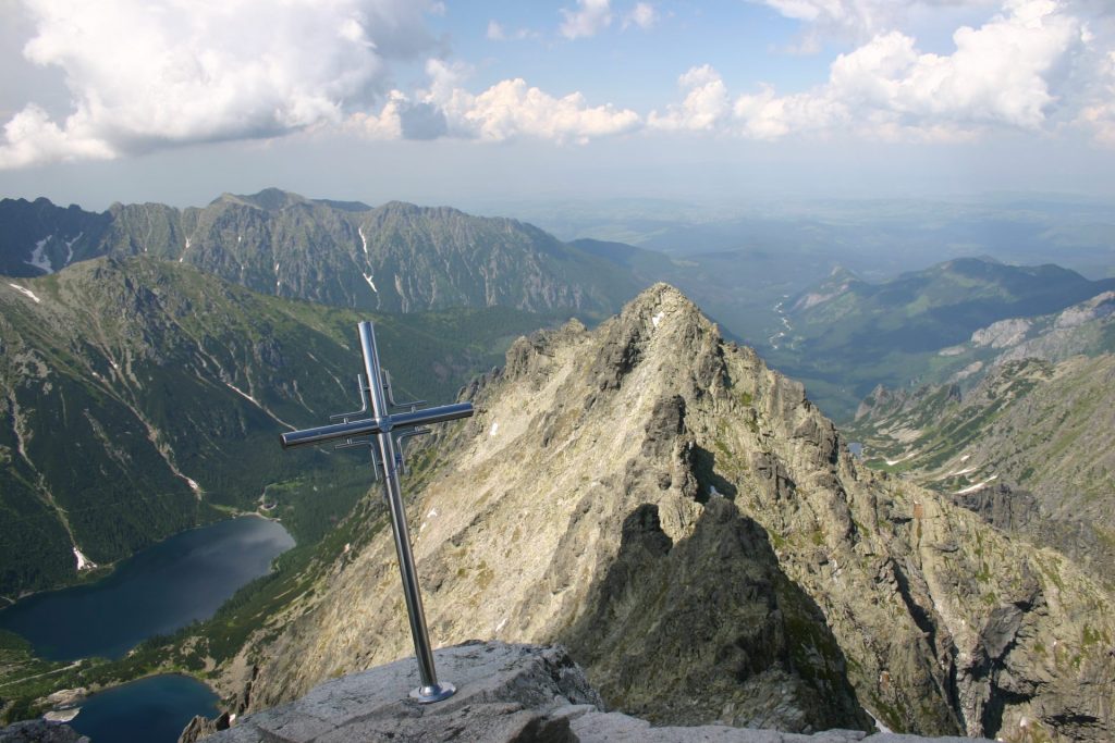
Rysy (2499 m) is the border peak between Slovakia and Poland in the main ridge of High Tatras. It has 3 peaks – prospective north-western (border) one, middle (main) one and south-eastern, the shortest one. There are three ridges running from the peak – to the north towards Malé Rysy, to the south through saddle Váha towards Český štít and to the west towards Žabí kôň. Rysy belongs among the most visited Tatra peaks. For the wide perspective which it provides, it was propagated before the 1 st World War as Hungarian or Tatra ‘Rigi’. The first known ascent was performed by the administrator of Starý Smokovec Eduard Blásy (1820-1888) with a mountain guide Ján Ruman Diečny Sr. on the 20 th of July in 1840 and later on the 10 th of April in 1884 by Teodor Wundt with Jakub Horvay. The first ascent was remembered by the marble plaque in the 90s of the 19 th century. Marie Curie-Sklodowska (1867-1934) with her husband Pierre visited Rysy in 1899 and later in 1913 there went Vladimir Ilyich Lenin. Rysy has got three peaks in the main ridge of High Tatras.
We can get there from the tarn Popradské pleso (blue trail ) and from there (red trail ) to the peak.
We can see Morskie oko and Czarny staw from the top.
Tips for hiking:
Hike from Popradské pleso to Rysy
All-day interesting hike for tourists in good physical shape. Starting from tram station Popradske Pleso the asphalt road leads us to the tarn Popradské pleso (1:15h ) and two nearby standing chalets: Chata pri Popradskom plese and Majláthova chata. Here we can relax, refresh ourselves and recover before the climb to the peak. If we […]
Rezervujte si ubytovanie
Najbližie podujatia.

Rysy is the highest point in the Polish Tatras and in Poland and also the highest point in the High Tatras that you can reach without a mountain guide. You can reach Rysy from either the Polish side, hiking past Morskie Oko or from the Slovak side starting at Štrbské Pleso. We recommend going up from the Slovakian side and down on the Polish side. This is a very hard full day hike which can be completed in around 10 hrs with breaks.
How to get there
You can start your hike from the electric rail station at Popradske Pleso (following the asphalt trail) or you can start from the car park at Strebske Pleso (follow the sign for Popradske Pleso and then a red trail leading into the forest from the road). Both paths takes about 4km/1,5 hrs to reach the Popradske Pleso (Lake), we recommend that you go down the trail to the lake as it is one of the most beautiful lakes in the area. From the lake you need to back track to the split and follow the blue marked path for about 1,5km over the footbridge of Zabi potok untill the road will split again with the well marked red route that leads to Rysy. This path will start your mostly uphill walk and take you past the Valley of Frog Ponds (Kotlina Kabich Plies) and to areas where you will be using some chains to help you with assending the ridge. After about 3,5 hrs walk you will reach the mountain lodge Chata pod Rysami where you can visit the toilet and have something to eat or drink. From this point it is another hour to reach the top of Rysy, the views from here are truely amazing and well worth the climb.
Going back down, you can choose to go back the way you came or down the Polish side instead. The Polish side is slightly more technical and involves also some steep slopes with chains. It takes just over 3hrs to get down to Morkise Oko and the mountain hut there. Some people choose to stay over here as the setting is lovely and walking still another 1,5hrs might seem like a crazy idea to some. The road from Morskie Oko to the entrance of the National Park on the Polish side is wide and paved, quite uneventful but welcoming after a big day of hiking. From the entrance there are many mini buses to take you back to Zakopane.
Useful Information
- Contact us for transport here or in the summer to get a bus to Poprad
- We also do guided hikes to Rysy, you can contact us for more info
- You will need good hiking shoes and hiking layers for this trip.
- Take dry socks, headlight and snacks.
Back to hiking routes
Top ways to experience nearby attractions
Most Recent: Reviews ordered by most recent publish date in descending order.
Detailed Reviews: Reviews ordered by recency and descriptiveness of user-identified themes such as wait time, length of visit, general tips, and location information.
Also popular with travelers
Rysy - All You Need to Know BEFORE You Go (2024)
- (4.05 mi) Grand Hotel Kempinski High Tatras
- (9.76 mi) Willa Dewajtis
- (9.68 mi) Wellness Penzion Strachan
- (9.12 mi) Kontakt Wellness Hotel
- (8.28 mi) Grand Hotel Permon
- (6.57 mi) Starý Šmakovec Restaurant
- (9.99 mi) Casa Mia Restaurant
- (4.08 mi) Furkotka
- (6.64 mi) Spitz Restaurant and Bar
- (9.34 mi) La Playa Beach Bar & Chillout Lounge
Stories of a traveler around the world
Hiking route to Rysy: the highest peak in Poland
Zakopane, 30th July 2018.
Today it has been one of the days that has marked my journey. When I arrived in Zakopane, I set out to hike the top of Rysy, the highest peak in Poland, at 2499 meters. Climbing to the top of a country is not an opportunity that comes up every day and it sounded very tempting. I knew it was one of the most challenging routes in the Tatra Mountains and, since I started working at the hostel, only one person had made it. I was very curious to see if it was as difficult as it seemed and to test my physical and mental limits.
Quick facts about Rysy
The term “Rysy” means “scratches” or “cracks” and refers to the grooves in the steep summit. The mountain range is located right on the border between Poland and Slovakia, although only 30% of it is on the Polish side. Rysy has three peaks: the central one, at 2503 meters; the southeast one, at 2473 meters; and the northwest one, at 2499 meters. The latter is officially the highest peak in Poland as the other two are on Slovak territory.
The hiking route to Rysy is very challenging for several reasons. First, because it is a very long excursion (the whole trip can easily take about 12 hours). Second, because the last few hours have to be done with the help of chains over a fairly steep terrain. And third, because it is very important that the weather is good and this is not always the case, even in summer. In short, you need to be physically and mentally prepared and be lucky that there is no rain forecast the day you are planning to go.
The importance of the weather
The weather is one of the most decisive factors when it comes to climbing Rysy. If the weather conditions are unfavorable, it can be very dangerous. If you are in the middle of a hike in the mountains, and suddenly it starts to fall lightning that causes landslides, you can get hurt. In fact, our hostel manager warned us that every year people who don’t consider the weather forecast die trying to reach Rysy.
Last week it rained almost every day and it was impossible to make the trip. However, my colleague Jonathan didn’t give up and tried twice. The first time he went with Karl (another volunteer of the hostel) and the weather was so bad that they could not continue beyond the two lakes ( Morskie Oko and Czarny Staw pod Rysami). The second time he went alone and he made it until the second part of the chains because there were lightnings and rocks falling down. He and the other hikers had to turn around quickly.
This weekend I agreed with Andy (a guest from Australia) and my friend Karolina that, if the forecast was good, we would do the hiking route to Rysy today. Jonathan had tried just yesterday but according to the Internet the weather forecast looked better today. It was expected to be sunny in the morning and stormy in the afternoon/evening, but we were aiming to be back by then. We didn’t imagine that the hiking route would take THAT long.
Although the initial idea was indeed to climb Rysy, we knew that reaching the top was unlikely to happen given the circumstances. However, we decided to try and see how far we could go. If the weather turned against us or we were too tired, we would turn around.
The first part: from Zakopane to Morskie Oko
We met at 6:30 AM at the hostel to have breakfast before taking the bus to Morskie Oko, the starting point of the route, at 7:30. At the entrance of Palenica Białczańska , we bought the tickets to the National Park and started walking towards the lake. As in the previous hiking route to Morskie Oko , we did this part walking on the paved road, as it is the only way option. Nevertheless, there are a couple of shortcuts where you can do a little hike in the nature.
We arrived at Morskie Oko in 1:40 hours, and the first thing we did was to have a proper breakfast in the mountain hut. We were very hungry and we knew that we had a very long hiking rout ahead, so we took advantage of this first stop to get our strength back. I ordered scrambled eggs with sausages at “tourist price” because the quantity left much to be desired for what it cost. However, it was either that or nothing, because there was no other place to choose.
As we were having breakfast on the terrace, we looked at the mountains and saw how the peaks were completely covered by grey clouds. This was not a good sign because it meant that it was very likely that it would rain or that the weather would be bad on the top of Rysy. On the other hand, my friend’s knee started to hurt a lot and she decided to stay in Morskie Oko and go back to the hostel. Hiking Rysy with joint pain was not recommended at all. However, Andy and I wanted to give it a chance so, after breakfast and saying goodbye to Karolina, we set off for Rysy summit.
Second part: from Morskie Oko to Czarny Staw pod Rysami
We surrounded Morskie Oko until we reached the sign that indicates “Rysy – 3:50 hours”. This is where the ascent as such began, as the path had been practically flat so far. However, all this previous part was good to warm up our muscles before getting serious.

The climb to Czarny Staw didn’t feel technically difficult to me, but it was tiring because the path was very steep. Unlike my partner, I had to stop every 5 minutes to get some air and drink water, but one step at a time we went up and finally we reached the second lake. It took us about 45 minutes from Morskie Oko’s mountain hut .
Personally, I found Czarny Staw Lake more special and peaceful than Morskie Oko. There were fewer people and you could tell it wasn’t as touristy (maybe because of the steep way up?). Also, the fact that it was in a higher area and located just below the imposing Rysy mountain range made the views even more impressive.

From here, we started the next stage of the hiking route: to surround the lake until taking the path up to Rysy. Along the way, we were looking at the mountains that stood before us. Indeed, the peaks were still completely dark and hidden by the grey clouds.
Third part: the climb from Czarny Staw
The rocky part.
After surrounding Czarny Staw we continued along the red trail which is an ascending path of stones and rocks. This was an easy but tiring trail because there was no flat part at all. At some points you had to climb some rocks and use your hands as the terrain was very steep. There were also sections where the surface was slippery and you had to be careful not to fall.
There were spots where you could sit on a rock and enjoy the breathtaking views of the lake and the Tatra Mountains behind. As we climbed, we were looking back all the time to see if we could see the two lakes from where we were. We knew we would get there at some point because Morskie Oko is lower than Czarny Staw and would have to appear behind it sooner or later. However, we could see Czarny Staw but no sign of Morskie Oko. It wasn’t until quite a while later that we started seeing both lakes.

As we climbed to Rysy, the path became narrower. Besides, the fog was more and more evident and there was a time when we could not see the way we had come from. We could see neither the lake, nor the mountains, nor the path, nor the sky… Nothing. We were totally surrounded by clouds. We could also feel the change in temperature because it was colder and we had to put on our jackets.
Arrival at the chains part
Step by step, we reached the part where the climb with chains began. This was already quite an achievement because we didn’t expect to make so much progress on the hiking route to Rysy. However, it was clear that the weather was not with us and that it could start pouring at any moment. The problem was that we had no waterproof clothes or mountain equipment at all, so it was not a plan to risk lifes.
Before we started the chains part, we asked a couple of hikers who were coming back from Rysy to evaluate the situation. Everyone, absolutely everyone, told us not to continue. They said that it was too late, that there were two more hours to the top and that the weather was not promising. However, we thought that it was not that late, that we were not tired and that it was not raining, so we decided to go a little further…

And we started the chains part. Just after the first ones, there was a critical moment because we heard a thunder. We were afraid that it would start pouring, so we thought we’d turn around. As a matter of fact, we did. However, because this is how life is, the sun suddenly came up again and we saw that the people who were near us were still there. So, again, we decided to give it a try and continue a little longer.
Along the way, Andy and I encouraged each other when we felt that the mood or strength to continue the hike was declining.
Fourth part: the climb with the chains
When we reached the chains my friend wasn’t very convinced but I felt like trying at least one part of it. We had come all the way there and I wouldn’t feel satisfied without even trying. We did a couple of chains and we saw that it wasn’t as difficult as we thought, so we continued.

At this point we were relatively close to Rysy’s peak and we didn’t want to give up. We asked some hikers again how much time we had until the top and they answered the same as before: we had two hours left (still?!!), the weather was unfavourable and if we wanted to climb Rysy we should have had to get up much earlier. However, we saw that people were continuing and we asked ourselves: if they can, why can’t we?
We climbed with chains for about two hours. I found this part relatively challenging and tiring, but not difficult on a technical level. I had never climbed with chains before (except for the day of the caves hiking route ) and I was able to do it without problems, but you need to be physically and mentally prepared. In my opinion, the chains helped us a lot in some sections but there were others where they were not completely necessary. You could hold on to the rock and go to the next level without using them.

There were some moments when we could see both lakes if we looked down. However, most of the time there was so much fog that we couldn’t see almost anything of the landscape. On the contrary: the higher we were, the less visibility we had.

Fifth part: the final hike to the top
During the whole climb with the chains, we went along with a group of girls who were perfectly equipped with helmets, technical clothes and a backpack with mountain material. On the other hand, we were wearing nothing but our sports clothes and a small backpack with water and something to eat.
The last part of this hike was the one that gave me the most respect. The path was narrow and the slope very steep, and underneath we had nothing but the cliff. There were no rocks or any kind of surface, and if you put your foot in the wrong place you could literally fall down. We were at all times “glued to the rock” and held on to the chains. To give you an idea, the path was like if we had to go round one mountain and stand on another.

The weather was changing all the time. The fog came and went, and the landscape changed in a matter of seconds depending on whether we had the sun on our side or not. We were very lucky because it didn’t rain at all. And thank goodness… because I was wearing nothing but a plastic poncho.
I was very encouraged to see that the hikers ahead of us could continue the route without any problems. If they could, so could we! During the ascent we met a group of very nice Spaniards coming from the top of Rysy. They told us that we only had 15 or 20 minutes left, so we put all of our last energy on it.
An important thing to consider…
Before continuing, I would like to highlight that I believe that the climb to Rysy’s summit is not for someone who is afraid of heights. You can have a hard time, especially from the beginning of the chains on.
To my surprise, I managed quite well during this part despite all the insecurities I had. Not only that, I realized that I enjoy these kinds of trails. I felt very comfortable going up the mountain and even overtook my colleague and other hikers who were going slower.
Sixth part: Rysy’s summit, here we are!
You can’t imagine how I felt when we finally reached Rysy’s summit. I couldn’t believe it… we had made it! Against all forecasts, and with all the odds of being a failure on a hike, there we were. At 2499 meters, on the highest peak in Poland. We reached the top at 2:30 PM, after a six and a half hour hike. At the summit there were about 30 people, many more than I imagined.

From the top you could see both sides of the Rysy mountains: Poland on one side and Slovakia on the other. On the Polish side you could enjoy privileged views of Morskie Oko, Czarny Staw and the Tatra Mountains. On the Slovak side you could see the mountains and a small lake that stood out because of its turquoise blue colour.

We used our short stay at the top to eat something, recover our strength, take some pictures and enjoy the impressive scenery when the sun and the clouds allowed it. From there, we had the chance to continue to the other two peaks of Rysy, which are in the part of Slovakia. However, the weather suddenly changed and it began to cloud over. We were at the top for about 20 minutes and, given the forecast, we decided to start the way down.

Seventh part: the way down
From rysy to morskie oko.
There was a moment of tension because we couldn’t find the red trail signal to return. We went down the way we “thought” we had come but were totally out of place. Besides, there was no one to ask and we saw ourselves wandering around the mountain with no direction. Luckily, a few minutes later a group appeared and showed us how to get to Morskie Oko.

We couldn’t see anything underneath because of the fog. In fact, we couldn’t see anything within a few feet of us. We were a bit concerned so we started to go down quickly so that we wouldn’t get caught in the rain.

For the descent, we used the chains less and preferred to go down “on your ass” on most sections because it seemed easier and safer. On some occasions we did use the chains and went down on our backs so as not to slip. Once we finished this part we joined the slippery rock path to get to Czarny Staw. From there, we bordered the lake and went down again to Morskie Oko.

Of course, now that “the worst” part was over, we took some pictures on the way down:

From Morskie Oko to the bus
We arrived at the shelter very tired. The first thing we did was to spoil ourselves and ask for a couple of beers and something to eat. And you won’t believe what happened, but as soon as we went out to the terrace with our menus… it started raining! We were quite lucky because if we had taken a little longer to do the route we would have been caught by the deluge in the middle of the mountain.
When the rain stopped, we continued our journey along the road to return to Palenica Białczańska. In total, it took us 6 hours to get down from Rysy to the entrance of the park. We took the bus back to Zakopane at 8:30 / 9:00 PM. We were among the last people who left the park at that time and the bus was not full, contrary to when we arrived.
Back to the hostel
When Andy and I arrived at the hostel my mates couldn’t believe their eyes. We are the second (after Jaden, a boy from America) to have reached the Rysy summit since I work at Good Bye Lenin Hostel . For the moment, I can already cross one of the “must things to do” off my list and I can assure you that nothing is impossible if you put your mind to it. Never say never!
In this link you can find the complete trail we did from Palenica Białczańska to Rysy, in case you want to take a look.
Published by Raquel Herrera
View all posts by Raquel Herrera
Leave a Reply Cancel reply
Your email address will not be published. Required fields are marked *
Rysy Hike to the Highest Mountain in Poland via Slovakia
The Rysy Hike is located in the beautiful High Tatra Mountains where the trail starts in Slovakia and peaks in Poland. In fact, Rysy Peak is the highest mountain in Poland and the highest mountain in the Tatras that you can hike without a guide.
Standing at an altitude of 2,503 meters or 8,212 feet, hiking to Rysy Peak promises an unforgettable adventure. The hike up Rysy Mountain offers stunning panoramic views of the surrounding landscapes, glacial lakes, picturesque valleys and rugged peaks.
In this article, we’ll get into all the details to prepare you for a trip to the High Tatras Mountains in Slovakia. I’ll cover everything you need to know about the Rysy Hike, including how to get to the trailhead, what to expect, and any other useful tips to know before you go hiking in Slovakia.

For full transparency, I have sprinkled some affiliate links in this post which gives me a small commission at no extra cost to you if you decided to make a purchase. As always, I would never recommend a product or service that I didn't truely believe in. If you find this post useful, you can also treat Jess to a cup coffee by clicking the icon on the bottom of the page. This will allow me to continue to create more content for you to enjoy ☕️.
Table of Contents
About Hiking Rysy Peak
The Rysy hike to Rysy Peak is an adventure that takes you to the highest point in Poland. Situated in the High Tatra mountain range which straddles the border of Slovakia and Poland.
There are two approaches to reach the summit of Rysy Peak.The most popular route begins from Zakopane, Poland at Morskie Oko Lake, and ascends through scenic landscapes, passing the mountain hut known as Schronisko PTTK Murowaniec.
There’s even a fun chains and ladders section. The final scramble ascent to the summit rewards hikers with breathtaking panoramic views of the surrounding peaks and valleys.
From Slovakia, you can hike from Štrbské Pleso, which is an easier route to the summit versus the route mentioned earlier. Hiking from Slovakia means that you can summit the highest mountain in Poland without ever really hiking in Poland. Pretty cool huh?

Rysy Hike Stats
- 💪 Difficulty: Difficult
- ⏰ Duration: Full day | 7 to 10 hours
- ⛰️ Elevation Gain: 4400 feet
- 🥾 Distance: 12.5 Miles Round Trip
Technically the hike starts Popradské Pleso but the only way to get to Popradské Pleso is by walking. To get here, you’ll have to park your car in Štrbské Pleso and walk the rest of the way to the alpine lake, hotel and restaurant.

How to Get to the Rysy Peak Trailhead | Slovakia
As mentioned earlier, the Rysy hike starts Popradské Pleso. First you must find parking in Štrbské Pleso. You’ll take an access road to get here. Just put these coordinates in your GPS.
If you get here early enough, which I recommend that you do, you can park on the side of the road. There are parking attendants and machines to buy a parking ticket.
There are also porter potties and what looked like a snack shop although it was closed when we arrived at around 7 am. There were still plenty of parking spaces available when we arrived and we hiked peak season in the beginning of August.
When we were returning to our car after the hike, we saw several tickets on windshields of vehicles as we walked by. Thankfully since we bought a ticket to park, we were not affected. Moral of the story is, they will fine you if you don’t buy a ticket.

Here is what to expect on the walk from Štrbské Pleso to Popradské Pleso:
- 💪 Difficulty: Easy
- ⛰️ Elev ation Gain: 900 feet
- ⏰ Duration: 45 minutes to 1 hour
- 🥾 Distance: 2.5 miles one-way
Follow the road north, cross over the train tracks, and up the paved road until you reach Popradské Pleso. There are signs pointing you in the right direction along the way.
Once you make it to the lake (Popradské Pleso), you will see signs for the trailhead to Rysy Peak on the lefthand side of the road. If you stay the night at this hotel on the lake, they will pick you up and you could avoid that part of the hike all together,
There are toilets and a restaurant at the lake as well if you need them. It is possible to hike around the lake, which takes about an hour. You have a long day ahead of you, so I’d save circumventing the lake for another day.

On Rysy Trail to Rysy Peak
- 💪 Difficulty: Hard
- ⛰️ Elev ation Gain: 3,400 feet
- ⏰ Duration: 3 to 5 hours
- 🥾 Distance: 3.7 Miles One Way
From here it’s 3.7 miles up to Rysy Peak. The first part of the trail gradually takes you up through an alpine forest.
Just follow the blue trail until you get to Mengusovská Valley. Then you take the red trail to mount Rysy. Trails are well marked and easy to follow.
You’ll pass over some rivers and see small waterfalls in the distance. There are plenty of large rocks you can crawl up on and take a breather and have a snack.

This is where the trail really starts to open up and shine. Next, we have the switchbacks. These are exhausting but all in all, they’re not that bad.
This is the more strenuous part of the hike but the views make up for it. And if the sun has made an appearance you may get lucky with a little sunlight on your face.
After the switchbacks you’ll enter a large boulder field which feels like the trail levels out. Then it takes you past a couple alpine lakes.

You can watch tiny dots crawl up the mountainside, as you really start to get a view of Rysy Peak from this part of the trail. From here, the trail turns to the rights and begins to climb up.
Two and a half, three hours in, we come to my favorite part of the hike, the chains and ladders. Sine you hike up the same way you hike down, expect a few slow parts and traffic jams if you get a late start.
We started the Rysy hike at 7 am and made it to the chain section way before anyone would be coming down the chains. The chains and ladders, were wide and easy to navigate.

Reaching Chata pod Rysmi on the Rysy Hike
45 minutes later you’ll reach the Chata pod Rysmi. This is a lodge almost seems like a mirage as it’s located smack dab in the middle of a boulder field.
This bar and restaurant is a great place to take a break or use the bathroom. It has one of the most scenic views from a toilet that I have ever seen.
We went into the lodge and had a couple beers on our way back down the mountain. We waited in line at that scenic bathroom I mentioned earlier for almost an hour!
You’re in the middle of a boulder field, and there aren’t many places to duck off if you have an emergency. Our options were to hold it or wait in line. We waited and needed to warm up in the lodge.

From Chata pod Rysmi its a fun hour steep rock scramble to the summit. There are a couple different spots to sit on at the summit. When we hiked, the trail looked busy on the switchbacks and it felt very crowded at the summit.
You did it, you’re standing on the tallest peak in Poland. Once you’re done catching your breath and taking pics, return back the way you came.
Rysy Hike Travel Vlog
Would you rather see what hiking Rysy Peak is like? Joe and I filmed the Rysy hike in August after spending the entire summer in the Balkans.
Check it out after you read this post and please subscribe or give us a thumbs up. It doesn’t cost you anything and really helps us be able to continue creating free content for you to enjoy 🙂.
🎥 Watch our Slovakia Series on YouTube
Join the Newsletter
Subscribe for Hawaii Travel Tips, my Latest Content and Much More.
When is the Best Time to Hike Rysy Hike
The best time to hike Rysy trail is in the summer from the end of May to September. Any other time, the trail is covered in snow making it impossible to hike.
We did some High Tatras hiking in the beginning of August and it was lightly snowing on us at the lodge and summit. I’ll go over what to bring in the next section but do dress warm when hiking Rysy Peak.

Tips for Hiking the High Tatras on Rysy Hike
- Temperatures can get cold, bring warm clothing.
- You need your own transportation to complete this hike.
- Leave no trace.
- Bring ample water.
- Bring snacks.
- Wear proper hiking shoes.
- Check the weather before you hike.
- Start early. This is a popular hike in Slovakia.

What to Pack for Hiking Rysy Peak
- Hiking boots
- Hiking poles optional
- Trail Mix/ Snacks
- Cold Weather Clothing – Gloves, Hat, Warm Jacket
- Cash for the lodge
Where to Stay in High Tatras Slovakia
There are a few different towns that make a great base to go hiking in the High Tatra Mountains – Tatranská Lomnica, Štrbské Pleso, and Poprad.
When I went hiking Rysy Peak, I stayed in Tatranská Lomnica at Vila Mala Marta . It was a nice budget friendly accommodation that we were able to get last minute.
Hotel Lomnica is an excellent choice if you prefer a bit of luxury after a day of hiking. This would be my choice if I ever return.

Other Noteworthy Hikes Around the World
Looking for more worldwide trekking adventures? I have only just started to properly document all of my hiking/trekking excursions. Below are a few hikes that stand out from the rest.
Salkantay Trek – 46 miles in completion that takes you through rugged mountain terrain and connects Cusco to Machu Picchu. The maximum elevation of this trek is at 15,090 feet at the Salkantay Pass.
Colca Canyon – Offers trekkers a chance to spot soaring condors, stay in an oasis on the canyon floor, witness some of Peru’s most beautiful landscapes, bathe in thermal hot springs and hike through desert scenery.
Valbona to Theth Trek – An adventure through the Albanian Alps hiking connecting Valbona and Theth National Park.
Haleakala Volcano – Hiking into the world’s largest dormant volcano on Maui, staying the night in a cabin and hiking out another route.
Overnight Trek on Acatenango – This overnight trek has you sleeping on a volcano for a front row views of an active volcano erupting through the night.
Final Thoughts on Hiking the Rysy Hike
The Rysy hike offers stunning views, glacial lakes, and rugged peaks. From the fun chains and ladders section to the insane restaurant smack dab in the middle of a boulder field, there’s many reasons to love this hike.
Plus how many people can say that you started hiking in Slovakia and ended up at the highest peak in Poland. If you found this article useful, let fellow travelers know in the comments below 👇.
Europe Travel Guides ↓
I haven’t traveled much in this part of the world. Here are the guides that I do have.
Best Things to do in Budapest
Eger Hungary & Bull’s Blood Wine
Enjoy this Post?!?! Pin in for Later ↓

Submit a Comment Cancel reply
Your email address will not be published. Required fields are marked *
Save my name, email, and website in this browser for the next time I comment.

Follow me on social media

Hi, we’re Jess (& Joe). We hope you’re enjoying our free travel guides and tips. If so please consider buying us a coffee ☕️. We appreciate your support!

🎥 Do you follow us on You Tube? Subscribe to follow along on our adventures!

Popular Posts
Wolności 219
- +48 883 777 209
Infolinia z konsultantem
Pn - pt: 11:00 - 16:00
Telefonicznie lub na czacie FB w godzinach 9:00-17:00
Chcesz poznać dokładny plan wycieczki?
Zjedź na dół i kliknij „Sprawdź szczegóły” aby zobaczyć plan ramowy wycieczki
Najpiękniejsze miejsca
Akceptujemy bon turystyczny, licencjonowani przewodnicy, harmonogram wycieczek.
- Październik
Nadchodzące wycieczki
Zapisz się na jedną lub więcej z nadchodzących wycieczek z mobilnym biurem podróży Mobile Tour!

Podziemny Lodowiec i Lewocza
Saksońska szwajcaria, morawski kras i brno, majowa praga, sip – szypska fatra, skalne grzyby – spływ pontonowy + grill, drezyny, lawendowe lody, mini zoo i zamek, czerwone wierchy + w cenie kolejka na kasprowy wierch, broumowskie ściany i huśtawka nad przepaścią, słowacki raj – dla spragnionych przygody, jaskinia mroźna i dolina kościeliska, zoo ostrawa – czeskie safari, ogrody kapiasa – idealny pomysł na dzień matki, dzień matki – kwitnące azalie – zamek w mosznej + interaktywne muzeum polskiej piosenki w opolu, rumunia i zamek draculi.
Social media
- Organizacja wycieczek
- Korona Gór Polski
- Misja firmy
- Archiwum wycieczek
- Regulamin sklepu
- [email protected]
- ul. Wolnosci 219 41-800 Zabrze
- KARTA STAŁEGO KLIENTA
- BON TURYSTYCZNY
- INSTRUKCJA ZAPISÓW NA WYCIECZKI
- HARMONOGRAM WYCIECZEK
- KGP – o co w tym chodzi? :)
- Kup unikatowy plakat KGP
- Szczyty zaliczane do KGP
- Cykl wypraw KGP czyli Korona Gór Polski – najczęściej zadawane pytania
- Wpis do Rejestru Organizatorów Turystyki i Certyfikaty
- Dokumenty do pobrania
- Ogólne warunki uczestnictwa – OWU
- Numer Konta bankowego
- COVID zalecenia
- MIEJSCA ZBIÓREK – PRZYSTANKI
- Zaloguj / Zarejestruj
Nazwa użytkownika lub adres e-mail *
Hasło *
Zaloguj się
Zapomniałeś hasła? Zapamiętaj mnie
No account yet?
Privacy Overview
- Route planner

Top 8 Hikes and Walks around Czarny Staw pod Rysami
Czarny Staw pod Rysami
Hiking around Czarny Staw pod Rysami
Looking for the best hikes and walks around Czarny Staw pod Rysami? Then browse our collection of routes around this beautiful lake in Tatra below. We present you with hiking trails around Czarny Staw pod Rysami — all you’ve got to do is pick your favorite and get going.
Plan. Save. Navigate. Your best adventures await.
Start today with a free komoot account.
View of Morskie Oko – Mickiewicz Waterfalls loop from Roztoka
Morskie oko – rysy loop from roztoka.

Let us show you the way with the komoot mobile app
Przedni staw – wielka siklawa loop from roztoka, schronisko morskie oko – 5 lakes view loop from roztoka, morskie oko – ausblick über morskie oko loop from roztoka.
Our Tour recommendations are based on thousands of activities completed by other people on komoot.
Popular around Czarny Staw pod Rysami
Mountain Climbing Collection by komoot
Find the perfect Tour
Explore the most popular tours around czarny staw pod rysami.
Explore more of Tatra : Browse the best Hikes in other regions.
- Tatra National Park, Poland
- Bukowina Tatrzańska
- Kościelisko
- Morskie Oko
- Wielki Staw Polski
- Czarny Staw Polski
- Czarny Staw Gąsienicowy
- Biały Dunajec
Top ways to experience nearby attractions
Most Recent: Reviews ordered by most recent publish date in descending order.
Detailed Reviews: Reviews ordered by recency and descriptiveness of user-identified themes such as waiting time, length of visit, general tips, and location information.
Also popular with travellers
RYSY: All You Need to Know BEFORE You Go (with Photos)
- (4.05 mi) Grand Hotel Kempinski High Tatras
- (9.76 mi) Willa Dewajtis
- (9.68 mi) Wellness Penzion Strachan
- (9.12 mi) Kontakt Wellness Hotel
- (8.28 mi) Grand Hotel Permon
- (6.57 mi) Starý Šmakovec Restaurant
- (9.99 mi) Casa Mia Restaurant
- (4.08 mi) Furkotka
- (6.64 mi) Spitz Restaurant and Bar
- (9.34 mi) La Playa Beach Bar & Chillout Lounge

- Alle Touren
- Hüttentrekking
- Tourenempfehlungen
- Rother Alpenvereinsführer
- Tourenplaner
- Gemeinsame Touren
- Aktuelle Bedingungen
- Hinweise und Sperrungen
- Lawinenlage
- Mit Kindern auf Hütten
- Mit Öffis zum Berg
- Service für Mitglieder und Sektionen
- Das Abo-Modell auf alpenvereinaktiv.com
- Monats- und Jahresgutscheine
- Hilfe-Seite
- Video Tutorials

Peut-on skier à Rysy?

Sicherheitshinweise
Wegbeschreibung, öffentliche verkehrsmittel.
mit Bahn und Bus erreichbar
Koordinaten
Buchempfehlungen des autors, kartenempfehlungen des autors, ähnliche touren in der umgebung.
- Summit tour to the Rysy (Tengerszem-csúcs, 2499 m)
- Summit tour to the Kôprovský štít (Kapor-csúcs,2363 m)
- Zum dreigipfeligen Rysy (2499 m)
- Von Popradské Pleso zum Rysi
- Rysy von Strebske Pleso 31.Juli 2023
Fragen & Antworten
Bewertungen
Gib die erste Bewertung ab und hilf damit anderen.
Fotos von anderen
Wetter am startpunkt der tour.
- Bilder einblenden Bilder ausblenden
- Schneehöhe Mit Pro+ freischalten

Hear our history, experience our culture, see our natural beauty, feel our soul, and enjoy the heart of our beautiful city.

City of Mobile Trolley Tour
Celebrate mobile aboard one of our beautiful climate controlled trolleys.
Pick up the rhythm of the place where Mardi Gras began and you will know why we are Born to Celebrate! Our 90-minute fully narrated tour takes you down moss covered streets in front of buildings with stories to tell and along one of the most diverse eco-systems in the country. Here, a rich past meets a modern thriving culture with something to offer everyone. Museums, historic homes and buildings, parks, fountains, music, food, drink, and entertainment all abound along our route. It's all So Mobile!
Visit Mobile Welcome Center
111 South Royal Street

USS Alabama Battleship
2703 Battleship Parkway

Departure Locations
Tour schedule, tour pricing.
Kids 12 and under are free
For parties of 10 or more, please call our office for prices. Special pricing and times can be accommodated for your group.
Reservations are not required

We are dog friendly

Wheelchair lift available
(by request only)
Route Highlights
Locations Visited Includes The Following
COLONIAL FORT CONDÉ
Church street cemetery, callaghan's irish bar & washington square, oakleigh historic complex, carnival museum, gulfquest / al cruise terminal, battle house hotel, richard's dar house, african american museum, bienville square, uss alabama.

251-633-0560
251-633-4012, [email protected], www.gctbus.com, © 2024 by travis roy.
COMMENTS
The middle summit of Rysy in Tatra Mountains is standing tall at 2499 meters is the highest peak in Poland, while the other two are nestled on the Slovak side with the highest reaching 2501 meters, and the other at 2473 meters. If you want to know, the highest peak situated entirely in Poland is Kozi Wierch, a part of the famous Orla Perć range.
Rysy trail starts in Palenica Białczańska in Zakopane. It's also called Morskie Oko parking. It's open 24/7. It's the trailhead to some of the most beautiful hikes in High Tatras (including the famous Valley of The Five Lakes).. Morskie Oko parking is extremely popular - when we got there before 7 AM it was already half full. he parking is massive but it's not enough to handle the enormous ...
Hike through some of the most picturesque mountain scenery on your way to the summit on the border of Slovakia and Poland. Rysy is located in the main ridge of the High Tatras mountain range, right on the border of Slovakia and Poland. At 2,499 meters, Rysy claims the tallest peak of Poland, and even has an additional peak on the Slovak side.
Routes leading to this Highlight may be dangerous. Routes may comprise technical, difficult, or hazardous terrain. Specialist equipment and prior experience may be required. Tips. chinczyk. Rysy the highest peak in Polish ( 2499 m. a.s.l. ) November 9, 2015. PeterStar. When the weather is nice, there are often waiting times below the summit.
Rysy is an intermediate trail. You need previous hiking experience in alpine terrain. In Poland, you can get the necessary experience on Świnica or Kościelec. You'll need A LOT of stamina. The stamina to go up and down 1.5 km, to be precise. Don't choose Rysy as your first destination in the Tatra Mountains.
First, an 8 km walk from the parking lot to Morskie Oko, then an ascent to Czarny Staw and then a sharp climb for 2 km on a slope with a 30-60 percent slope. In many sections, facilities in the form of chains, clasps and forge steps in the rock, without which the average hiker or tourist would not be able to cope.
Rysy, Tatra National Park: See 58 reviews, articles, and 148 photos of Rysy, ranked No.7 on Tripadvisor among 13 attractions in Tatra National Park. ... Full day Tour Zakopane Snowmobiles Thermal Baths from Krakow. 10. Recommended. 90% of reviewers gave this product a bubble rating of 4 or higher. Full-day Tours. from . C$175.64. C$140.51. per ...
Standing at 2499 metres, Rysy Mountain is the tallest mountain in Poland. Located in the High Tatras, Rysy actually straddles the border between Poland and Slovakia and can be hiked in either direction. We were visiting Poland for a week when we hiked Rysy. We were staying in the beautiful mountain town Zakopane, two hours from Krakow.
Routes Slovakia Summit tour to the Rysy (Tengerszem-csúcs, 2499 m) Share Bookmark Make a Video My Map Print GPX KML FIT Plan a route here Copy route Plan a joint trip Embed Fitness Report a Concern Top recommended route Summit tour to the Rysy (Tengerszem-csúcs, 2499 m) ...
Rysy. Situated on the border of Poland and Slovakia in the High Tatras, Rysy is a rugged mountain peak with three rocky summits of varying heights. The northwestern summit ( 8,202 ft) is a part of the Crown of Polish Mountains and is actually the highest point in that country, while the middle ( 8,205 ft) and south-eastern ( 8,114 ft) summits ...
Rysy (2499 m) is the border peak between Slovakia and Poland in the main ridge of High Tatras. It has 3 peaks - prospective north-western (border) one, middle (main) one and south-eastern, the shortest one. There are three ridges running from the peak - to the north towards Malé Rysy, to the south through saddle Váha towards Český ...
Rysy is the highest point in the Polish Tatras and in Poland and also the highest point in the High Tatras that you can reach without a mountain guide. You can reach Rysy from either the Polish side, hiking past Morskie Oko or from the Slovak side starting at Štrbské Pleso. We recommend going up from the Slovakian side and down on the Polish ...
After 1- 1.5 hours from the second lake, you are faced with two options: 1) The official route (with chains) is exposed but a really fun climb. 2) The unofficial winter route (recommended by locals for winter) is a gully straight to the right of the chains route - it is safer than the chains but much much harder work.
Rysy has three peaks: the central one, at 2503 meters; the southeast one, at 2473 meters; and the northwest one, at 2499 meters. The latter is officially the highest peak in Poland as the other two are on Slovak territory. The hiking route to Rysy is very challenging for several reasons. First, because it is a very long excursion (the whole ...
The Rysy hike to Rysy Peak is an adventure that takes you to the highest point in Poland. Situated in the High Tatra mountain range which straddles the border of Slovakia and Poland. There are two approaches to reach the summit of Rysy Peak.The most popular route begins from Zakopane, Poland at Morskie Oko Lake, and ascends through scenic ...
Zapisz się na jedną lub więcej z nadchodzących wycieczek z mobilnym biurem podróży Mobile Tour! 249 zł 12.05.2024 Kontakt Zoo - Obcując ze zwierzętami + Liptovski Mikulasz. Sprawdź szczegóły. 209 zł 19.05.2024 Podziemny Lodowiec i Lewocza -uwaga zmiana terminu z 12/05 na 19/05 !! ...
Although Rysy is the highest peak in Poland (2500 m/8200 ft.), it's relatively easy to climb it to the top. The hike is quite tiring and steep; nevertheless, it's nowhere near as difficult as some other trails in the Tatras - like, for example, the trail to Zawrat via Dolina Gasienicowa which is my favorite in the whole Tatars.
Rysy ( Polish: [ˈrɨsɨ] ⓘ; Slovak: [ˈrisi]; German: Meeraugspitze, Hungarian: Tengerszem-csúcs) is a mountain in the crest of the High Tatras, eastern part of the Tatra Mountains, lying on the border between Poland and Slovakia. Rysy has three summits: the middle at 2,501 m (8,205 ft); the north-western at 2,500 m (8,202 ft); [4] and the ...
Morskie Oko - Ausblick über Morskie Oko loop from Roztoka. Expert Hiking Tour. Good fitness required. Sure-footedness, sturdy shoes and alpine experience required. to see even more hikes around Czarny Staw pod Rysami. Browse the best walks around Czarny Staw pod Rysami and see interactive maps of the top 5 hiking trails and routes.
Full day Tour Zakopane Snowmobiles Thermal Baths from Krakow. 10. Recommended. 90% of reviewers gave this product a bubble rating of 4 or higher. Full-day Tours. from . £102.28. ... No, the trail onto Rysy from the Slovak side is being opened (like almost all the trails in Slovak Tatras) on June 16 and I guess in most years there can be little ...
Ähnliche Touren in der Umgebung. Summit tour to the Rysy (Tengerszem-csúcs, 2499 m) Summit tour to the Kôprovský štít (Kapor-csúcs,2363 m) Zum dreigipfeligen Rysy (2499 m) Von Popradské Pleso zum Rysi. Rysy von Strebske Pleso 31.Juli 2023. Diese Vorschläge wurden automatisch erstellt.
Mobile Trolley Tours' 90-minute fully narrated tour takes you down moss covered streets in front of buildings with stories to tell and along one of the most diverse eco-systems in the country. Here, a rich past meets a modern thriving culture with something to offer everyone. Museums, historic homes and buildings, parks, fountains, music, food, drink, and entertainment all abound along our route.