

Free Grand Canyon Trip Planner Kit
Download our free stunning Grand Canyon Trip Planner filled with an inspiring itinerary, gorgeous photographs, a park map and everything you need to plan your dream vacation. Order this insider’s guide to the Grand Canyon today to get tips on how to get there, what to do and where to stay.
Get even more trip planning information in our email newsletters and by selecting to receive email and/or mail from our Grand Canyon travel partners.
Featured Partners
Customize your Grand Canyon travel guide based on your road trip or airport approach to the park. On the form above, select to receive trip information directly from vacation partners for the regions you will be vacationing in.
Northern Arizona Grand Canyon Country
Discover the beauty of red rocks, lakes and historic Route 66 surrounding the park.
- Grand Canyon North Rim Lodge - Located within the Park the historic Lodge is nestled on the north edge at 8,100 ft with inspiring views of the Canyon. Featuring 218 guest rooms and cabins and various dining venues to fit your schedule.
- Lake Powell Resorts & Marinas - Lake Powell is the ultimate playground with nearly 2,000 miles of shoreline, perfect weather and some of the west's most spectacular scenery. Rent a houseboat or enjoy the resorts and take a guided tour.
- Lowell Observatory - Located in downtown Flagstaff, the gateway to the Grand Canyon, Lowell Observatory offers a vast public program including telescope viewing, world-class quarterly exhibits, daytime tours and multimedia shows
- Williams, Arizona - Williams is the Gateway to the Grand Canyon® and a true western community with cowboys ready to welcome you on Route 66.
- Cottonwood, Arizona - Take a stroll through this charming historic downtown packed with wine tasting rooms and restaurants before heading to a rare solitude-fueled national monument.
- Prescott, Arizona - On your way to the Grand Canyon, stop at America's oldest saloon, wander Whiskey Row, then stay the night at comfy hotels.
- Flagstaff, Arizona - Located two hours from six national monuments and Grand Canyon National Park, Flagstaff is a thriving university town with a charming historic downtown.
- Yavapai Lodge - This eco-friendly lodge inside Grand Canyon National Park is located just a quarter mile from the canyon’s South Rim. Nestled in the woods, the lodge features locally sourced cuisine, air-conditioning, fire pits and lawn games.
- Chino Valley, Arizona - An undiscovered destination in the central Arizona highlands with vast, wide open spaces, Chino Valley is defined by friendly people, unique eating establishments and outdoor adventure.
- Red Feather Lodge - Stay at this beautiful Grand Canyon hotel with affordable, contemporary lodging and courteous hospitality just 1 mile from Grand Canyon’s south rim park entrance.
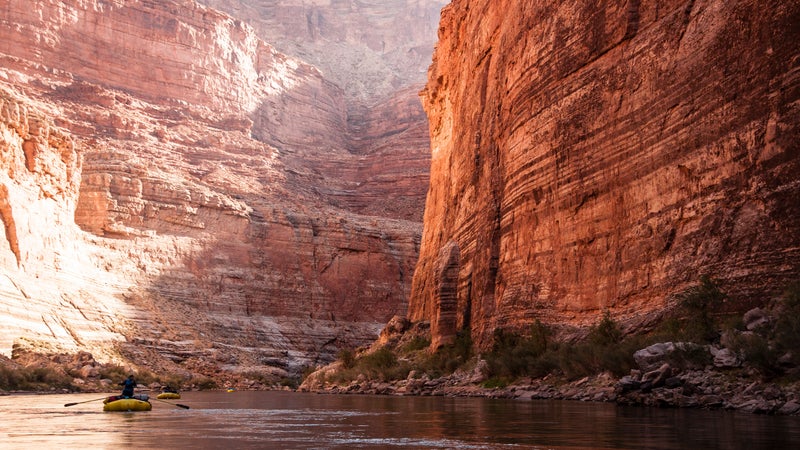
- Wilderness River Adventures - The rafting experience of a lifetime can be found on t he Colorado River. Take a thrilling motor-powered or oar-powered white water rafting trip through the Grand Canyon or embrace the stillness with a calm water trip down Horseshoe bend.
Greater Arizona Hot Spots
Add more Arizona parks and city attractions to your Grand Canyon trip.
- Arizona Office of Tourism - Visit the legendary Grand Canyon, one of the Seven Natural Wonders of the World and Arizona's most identifiable - and breathtaking - landmark. Request your Arizona Visitors Guide!
- Gilbert, Arizona - Ranked as “Phoenix’s Coolest Suburb,” and a “top 5 foodie neighborhood in metro Phoenix,” Gilbert is the perfect home base for Arizona explorations because of its close proximity to 22 national parks (including the Grand Canyon) and 35 state parks.
- Arizona State Parks - Explore hidden gems in Arizona's State Parks. Take a hiking trip, view geologic wonders or fish in remote areas.
Utah Stops on the Way
North of the Grand Canyon, five Utah national parks and mountain towns await.
- Kanab, Southern Utah - Stay in one place while visiting a multitude of national parks and national monuments in our area: Grand Canyon, Zion, Grand Staircase-Escalante, Bryce Canyon, Cedar Breaks, Pipe Spring, and Glen Canyon/Lake Powell.
- Visit Salt Lake - Long-known as the most convenient gateway to America's most stunning national parks, Salt Lake offers endless options and experiences for anyone and everyone.
- Visit Cedar City - National parks, the Utah Shakespeare Festival, Brian Head Resort, Parowan town - it's all here!
- Bryce Canyon Country - Just 20 minutes from Bryce Canyon National Park lies a string of towns like Panguitch, Escalante and Boulder that make for a great base to explore Utah’s red-rock country. From dark skies to slot canyons to local coffee, adventure awaits.
- Capitol Reef Country - Take in Utah’s stunning color palette in and around Capitol Reef National Park plus side trips to Goblin Valley, Bryce Canyon and a stunning scenic drive.
- Destination Moab: A Hotel Collection by Vista Host - Start planning your stay at one of Moab's Mighty Four- Expedition Lodge, Homewood Suites, Hampton Inn, and Holiday Inn Express. Enjoy hot breakfast, free Wi-Fi, and explore eastern Utah’s favorite national parks.
- Carbon County Utah - From the remarkable beauty of Nine Mile Canyon to the historic Main Street of downtown Helper, you won't run out of places and activities to explore in the Corridor.
- Natural Retreats Park City - Handpicked for prime mountain access and high-end amenities, these vacation rentals include private homes nestled on the slopes, luxury lodge condos at Silver Star, and ski-in, ski-out estates in gated communities at both Deer Valley Resort and Park City Mountain Resort.
Colorado Stops on the Way
Experience cliff-side ruins, steam-powered trains and mountain views in route.
- Mesa Verde Country - The welcoming communities of Cortez, Dolores, and Mancos nearby Mesa Verde National Park offer comfy accommodations, world-class dining, microbreweries and wineries, all kinds of outdoor fun, and visitor services.
Texas and New Mexico Stops on the Way
Explore Native American culture, New Mexican foods and park sites such as White Sands National Monument, Carlsbad Caverns National Park and Guadalupe Mountains National Park on your way to the Grand Canyon.
- Farmington, New Mexico - Farmington is your ticket to unlimited adventure. Rugged, wild scenery coupled with unique culture, it's here that outdoor lovers and active families thrive.
- Carlsbad, New Mexico - Located in the Chihuahuan Desert on the beautiful Pecos River, this oasis is the gateway to Carlsbad Caverns National Park.
- El Paso, Texas - The birthplace of Margaritas has a historic mission trail, stunning and serene places to get outdoors, and taco options from DIY to high-end creations.
- Alamogordo, New Mexico - From White Sands National Monument to alpine meadows high in the Sacramento Mountains, outdoor lovers love Alamogordo. Visitors will also find the birthplace of space exploration, a thriving performing arts center, surprising restaurants and top-flight golf.
- Deming, New Mexico - Explore a world-class museum, take in the charms of old Mexico in nearby Palomas, visit where Pancho Villa’s daring raid took place or sip award-winning wines at area wineries.
- Los Alamos, New Mexico - This small town is a cultural wonder. From ancient village sites and fascinating history to spectacular scenery and high-altitude adventures, new discoveries are waiting for you around every corner.
Tour Guides and Tour Apps
Don't miss a thing by following an expert - a literal "Grand Canyon Travel Guide."
- GuideAlong Grand Canyon Driving Tour App - Listen to an expert tour guide automatically play interesting and entertaining commentary as you go .
About Outside Interactive, Inc.
Grand Canyon
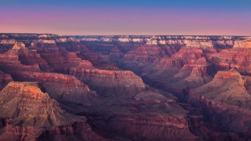
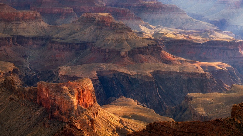
Vast, magnificent and inarguably beautiful, the Grand Canyon is easily Arizona's most distinguishable landmark — a natural wonder you must see to believe. Stretching 277 miles from end to end, the Grand Canyon's rocky walls descend more than a mile to the canyon’s floor, where the wild Colorado River continues to carve away at the rugged landscape. Everyone should see the Grand Canyon at least once in their lifetime, and area businesses and outfitters make experiencing the canyon accessible to everyone.

From the Rims
If you are short on time or prefer to take in fantastic panoramas from paved viewing points, simply visiting the Grand Canyon creates memories that stick with visitors forever. Grand Canyon National Park’s South Rim is the most popular visitor area, with plenty of places to eat, shop and stay the night in area hotels or campsites. The Grand Canyon Railway offers a fun family alternate for a short visit to the canyon. It operates turn-around trips from Williams to the South Rim year-round, with a three-hour window to see the canyon. Its annual Polar Express excursions are the stuff holiday traditions are made of. While less developed with fewer services and closed during the colder months, the North Rim is open from May to October and offers a unique and uncrowded way to explore the Grand Canyon. Grand Canyon West is also a favorite for short visits. Its Skywalk takes Grand Canyon visitors out over the rim on a glass bridge that hovers 4,000 feet above the canyon floor. Choose your vantage point and get ready to take pictures you will never delete.
From the Canyon Floor
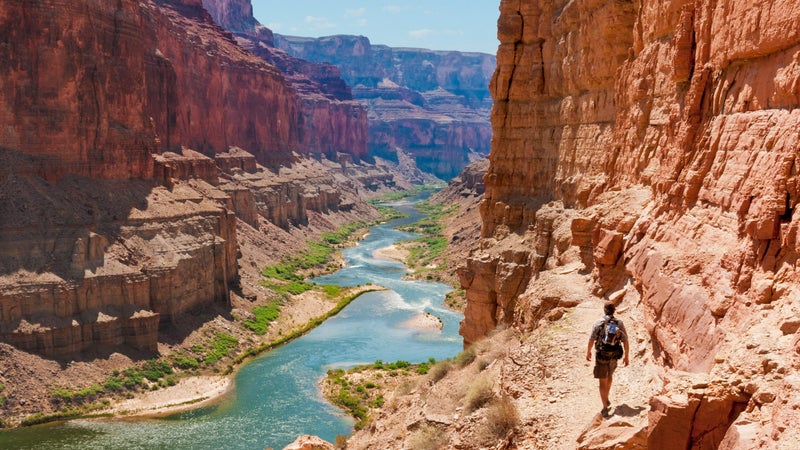
If your group leans more toward the adventurous side, find many ways to fully immerse yourself in this natural wonder of the world. Trailheads at any of the entry points lead to steep switchbacks that take visitors into the canyon. Commit to a few hours to hike to plateaus fully encircled by the canyon walls. To hike to the Colorado River on the canyon floor, plan to camp overnight before hiking back up from the river to the rim. Many experienced hikers join seasoned outfitters on grueling rim-to-rim hikes or multi-day backpacking adventures to fully immerse themselves in the splendor of the canyon. Outfitters also offer Grand Canyon white-water river rafting adventures on the Colorado River, which can last from half a day to two weeks. Helicopter tours, mule rides and mountain bike rim trails offer other memorable ways to see the canyon in person. Survey the adventure level of your travel companions, and then use the following resources to plan the adventure of a lifetime in the Grand Canyon.
3 Perfect Days in the Grand Canyon
This three-day itinerary in Grand Canyon National Park’s South Rim covers all the must-see stops and gives you the scoop on where to photograph the sunset.

3 Perfect Days in
The grand canyon, ways to explore.

Plan Your Trip
Getting to the grand canyon.
Find the best routes to reach the North and South Rims of the Grand Canyon.

South, North, and West Rims
The Grand Canyon is like a paintbrush, dipped in golds and pinks and oranges and purples, swept over narrows and crags in an area that’s an...

Arizona's Must Sees
Around the Rim Tours
Explore the Grand Canyon with a guided tour or ride – on a bike, on foot or perched atop a friendly mule.

Outdoor Adventures
First-Timer's Guide to the Grand Canyon
For those making their first trip to the Grand Canyon, here's an expert take on when to go, where to stay, and how to get around.

Grand Canyon Air Tours
See the canyon from high above with a helicopter or airplane tour.

Outdoor Adventure
Hiking the Grand Canyon
Explore the Grand Canyon by foot. From the most popular hike on the Bright Angel Trail to many more hikes that offer a scenic view.

Rafting the Canyon
Choose from motorized or oar-powered expeditions ranging from four days to two weeks for a new perspective.

Family Activities
Grand Canyon for Kids
Find out how your kids can become Junior Rangers during your Grand Canyon vacation.

Accommodations
Historic lodges, hotels to rugged campgrounds, the Grand Canyon has a wide range of places to stay – book early.

Awesome Grand Canyon Fun for Families
Experience Arizona's world-famous landmark through the eyes of a child (although these family friendly activities promise fun for all ages).

More to Discover in Arizona

Road Trips & Tours
The Old West, Wilderness and Wine: Traveling in Southeast Arizona
Discover the Wild West with gunfight reenactments and cowboys; savor treats from food trucks and fine restaurants; sip microbrews and...

13 Only-in-AZ Experiences
Arizona's a big state with a lot to see and do for just about anyone, but these 13 experiences are only found here.

Arizona's Roadside Attractions
Find all kinds of roadside sights—odd, unexpected and one-of-a-kind— across Arizona.

Grand Canyon After Dark
Grand Canyon National Park is one of the best places in Arizona to view the night sky and go stargazing.

- Link to site translated for China
- Link to site translated for Japan
- Link to site translated for France
- Link to site translated for Germany
- Link to site translated for Mexico
- Link to Arizona Office of Tourism's official Facebook page Facebook
- Link to Arizona Office of Tourism's official Instagram Instagram
- Link to Arizona Office of Tourism's official Twitter Twitter
- Link to Arizona Office of Tourism's official Pinterest Pinterest
- Link to Arizona Office of Tourism's official YouTube channel YouTube
- Link to Arizona Office of Tourism's official TikTok TikTok

Most Searched Stories

Request Your Copy
Official State Travel Guide

Top Annual Events

Sustainability
Appreciate AZ

Travel Inspiration
Cities & Regions
From the abundance of Saguaro cactuses and unique wildlife in the Sonoran Desert to the high country and forests of the White Mountains to the breathtaking Grand Canyon, Arizona’s regions are full of experiences that don’t disappoint.
- Search Please fill out this field.
- Manage Your Subscription
- Give a Gift Subscription
- Newsletters
- Sweepstakes
- National Parks
Everything to Know Before Visiting Grand Canyon National Park
Grand Canyon National Park is a must-visit — here's what you need to know before you go.
Evie Carrick is a writer and editor who’s lived in five countries and visited well over 50. She now splits her time between Colorado and Paris, ensuring she doesn't have to live without skiing or L'As du Fallafel.
:max_bytes(150000):strip_icc():format(webp)/evie-carrick-df91be43396540c492c4141c56a71a9e.jpg "grand canyon travel map")
Know Before You Go
Best time to visit, how to get there, best things to do, places to stay, places to eat.
Lauren Breedlove/Travel + Leisure
There are few natural wonders that can challenge the great jaw-dropping size and beauty of the Grand Canyon. It is a mile deep and 10 miles across, showcasing an eye-catching array of layered red rock that reveals millions of years of geological history in a single glance. It is a wonder that is so bold, big, and beautiful that it marks planet Earth in a scar that can be seen from space.
To see the 277-mile canyon, you should visit Grand Canyon National Park in northern Arizona, a protected area that contains most of the canyon and the Colorado River that runs through it.
“The canyon landscape itself is the main draw for visitors from all over the world,” said Joelle Baird, a public affairs officer at Grand Canyon National Park, in an email interview with Travel + Leisure . She has lived and worked at the Grand Canyon for 12 years and says the landscape is special for many reasons.
“Many visitors are surprised by how high in elevation we are here (7,000 feet on the South Rim, 8,000 feet on the North Rim), so we have ponderosa pine and juniper/pinyon pine forests that encompass the high desert landscape as well.”
To provide you with a comprehensive guide to the park, we leaned into Baird’s expertise. After 12 years working in and along the canyon — as a biological science technician, preventative search and rescue ranger, and now a public affairs officer — she offers a wealth of inside knowledge. Below are her recommendations on everything from when to visit to where to hike.
Don Eim/Travel + Leisure
Grand Canyon National Park straddles the canyon itself and is broken into two sections: the South Rim and the North Rim.
Most people see the canyon from the South Rim, which is open 24 hours a day, seven days a week, year-round and is home to the main Grand Canyon Visitor Center. The South Rim also has a second visitor center, Verkamp's Visitor Center, which focuses on the people who have lived along the canyon and showcases what it was like to live and work in the park. To get to the South Rim, you can enter at the South Entrance near Tusayan, Arizona or the East Entrance (Desert View) near Cameron, Arizona. Most people use the South Entrance.
“I would recommend visiting the South Rim for at least a few days if it's your first trip to the canyon. The South Rim has a lot of visitor services including hotels, restaurants, and ranger programming that is definitely worth checking out,” said Baird.
Meanwhile, the North Rim near the Arizona-Utah border is quiet and remote, and completely closed to visitors between Dec. 1 and May 14. It is quiet and beautiful on the North Rim, but it also has fewer services, even in the summer. The North Rim Visitor Center and Park Store is open from May 15 to Oct. 15.
If you want to visit both rims, you have to take a five-hour drive around the canyon. For that reason, most visitors choose to just visit one of the canyon’s rims.
To enter the park from any entrance, you’ll have to pay $35 per day, per vehicle, or purchase the $70 annual park pass. Grand Canyon National Park does not require reservations or time-entry passes to enter the park.
Most people visit Grand Canyon National Park between late May and early September. June, July, and August tend to be the busiest months. The quieter “shoulder seasons” run from March to May and September to October, while the low season runs November to March.
The South Rim, which is open year-round and is easier to get to, is always busier than the North Rim of the canyon, which is only open between May 15 and Oct. 15, weather dependent. If you’re planning to visit the South Rim over school holidays, summer break, or fall weekends, you should expect long lines, limited parking, and crowded viewpoints. To lessen wait times, you can buy your park pass in advance in Tusayan, the South Entrance gateway town; enter the park at the less-busy East Entrance; or take the Grand Canyon Railway from Williams, Arizona to the South Rim.
According to Baird, if you don’t need to visit the North Rim, winter can be an extra-special (and quiet) time at the South Rim. “As a resident of Grand Canyon, my favorite time is the winter! We typically receive low visitation and many of the popular viewpoints are uncrowded. It is a much quieter time and the contrast between the red rocks of the canyon and snow on the rim is a magical sight.”
The best time to see and photograph the Grand Canyon is typically at sunrise and sunset . Sunrise is between 5:11 and 7:40 a.m., depending on the season, while sunset fluctuates between 5:14 and 7:49 p.m.
Related: The Best Times to Visit the Grand Canyon
The closest town to the South Rim is Williams, Arizona, which is a direct one-hour-and-20-minute drive on Route 64. From the larger city of Flagstaff, the South Rim is one hour and 45 minutes via Route 180. Phoenix is the closest major city (and airport) and is three hours and 45 minutes away by car. Las Vegas is around four hours and 45 minutes from the South Rim.
Once you’re in the South Rim “village,” there are several free shuttle buses that take you to various viewpoints, sites, and trailheads around the rim. Some routes run year-round, while others are seasonal. Check the schedule on the website .
You can also get to the South Rim on the Grand Canyon Railway , which departs from Williams, Arizona. By taking the train, you can avoid entrance line waits and parking headaches.
The North Rim, which is typically open between May 15 and Oct. 15, is around two hours south of Jacob Lake, Arizona on Highway 67. Las Vegas, which is over 5 hours away by car, is the closest major city and airport to the North Rim. And as we previously mentioned, driving between the two rims takes a full five hours.
Lauren Breedlove/Travel + Leisure
Scenic Drives
One of the best ways to experience the size and beauty of the canyon is to drive the Desert View Drive along the South Rim. The road takes off near the South Rim village and continues along the canyon rim for 23 miles, passing six viewpoints and a Tusayan Pueblo site. A shuttle bus also runs along this route.
Hermit Road (formerly West Rim Drive) runs in the opposite direction of Desert View Drive on the South Rim and offers a completely different look at the canyon (with nine viewpoints). Hermit Road is closed to private cars from March 1 to Nov. 30. During that time, there is a free shuttle bus that runs along the road.
On the North Rim, you can drive between Cape Royal and Point Imperial on a scenic road with plenty of pullouts and viewpoints, including Walhalla Overlook and Roosevelt Point. Keep in mind the North Rim and its scenic roads are closed in the winter.
Related: Best Grand Canyon Viewpoints
If you’re interested in going down inside the canyon, a raft trip is a must. There are full and half-day river trips that can be arranged through lodging accommodations on the South Rim, along with multi-day excursions down the Colorado River (for the latter, you need to secure a permit in advance).
Merrill Images/Getty Images
Road Biking
On the South Rim, there are around 13 miles of bike-friendly road and greenway trail (including Hermit Road, formerly known as West Rim Drive). The shuttle buses have bike racks so you can bike out and ride the bus back. There are regular and e-bike rentals available from the Bright Angel Bicycles shop adjacent to the Grand Canyon Visitor Center on the South Rim.
Cultural Demonstrations
There are ongoing cultural demonstrations at the Grand Canyon Visitor Center on the South Rim. These free demonstrations allow park visitors to meet members of the area’s 11 Indigenous groups and watch how traditional and modern crafts are made.
Best Hikes
Canyon rim trail.
This flat route runs right along the rim of the canyon and is a great introduction to the park. It starts at the visitor center at the South Rim and follows the edge of the canyon, eventually running alongside Hermit Road, which has nine exceptional overlooks.
Trail of Time
The Grand Canyon has a long and beautiful geological history, and it’s showcased along the Trail of Time, which runs almost three miles round-trip along the canyon rim between the Yavapai Museum of Geology and Verkamps Visitor Center on the South Rim. Each meter walked on the timeline trail signifies one million years of Grand Canyon's geologic history, and there are samples of rock and exhibits that explain how the Grand Canyon was formed.
South Kaibab Trail
Baird says, “Day hikes into the canyon should definitely be on your list if it's your first time.” She recommends hiking along the South Rim’s South Kaibab Trail to Cedar Ridge (three miles round-trip) or Skeleton Point (six miles round-trip). Just keep in mind, the trail descends into the canyon and is extremely steep. The national park notes that “the openness of this trail lends itself to extreme heat during the summer months and little to no protection from passing storms.”
Bright Angel Trail
Another in-canyon hike on the South Rim that Baird recommends is the Bright Angel Trail to the 1.5- mile rest house or the three-mile rest house. This route follows in the footsteps of the canyon's Indigenous people, miners, and early tourists.
Transept Trail
This route on the North Rim follows the canyon rim from the Grand Canyon Lodge to the North Rim Campground. The canyon views are plentiful on this three-mile round-trip hike.
North Kaibab Trail
This is the only maintained trail that goes into the canyon from the North Rim. You can go as far as you want, with the Coconino Overlook and Supai Tunnel just 1.5 miles and four miles round-trip, respectively. The North Kaibab Trail goes all the way from the rim to the river at the bottom of the canyon, but the park warns that “Under no circumstances should you attempt to hike from the rim to the river and back in one day” as the route is 28 miles round-trip with a steep 6,000-foot descent.
Hotels and Lodges
On the South Rim of the Grand Canyon, there are seven year-round lodging options. Five are in the historic district and are bookable online at grandcanyonlodges.com . The other two are located on Market Plaza near the visitor center and can be booked on visitgrandcanyon.com .
Standouts include El Tovar Lodge in the historic district, which is located directly on the rim and is a National Historic Landmark. El Tovar has hosted park visitors like Theodore Roosevelt, Albert Einstein, and Oprah Winfrey. Maswik Lodge South just opened in June 2022 for visitors looking for a modern take on traditional national park lodging. And Yavapai Lodge on the Market Plaza is notable because it has clean, simple rooms and is pet friendly.
There are also plenty of places to stay outside the park near the South Rim, including the Grand Canyon Railway & Hotel in Williams, Arizona where the train to the Grand Canyon departs from. Baird notes that “staying close to the park during your visit ensures you can make sunrise and sunset times more convenient.”
On the North Rim, the only lodge within the park is the Grand Canyon Lodge , which fills quickly during the North Rim’s opening window of May 15 to Oct. 15.
Campgrounds
There are four campgrounds along the South Rim, including the year-round Mather Campground for tent camping and Trailer Village for RVs. The South Rim also has two seasonal campgrounds that open for the spring, summer, and fall: Desert View near the East Entrance and Ten-X Campground.
There are also two seasonal campgrounds on the North Rim of the canyon, the North Rim Campground and the DeMotte Campground. Neither have hookups.
Related: Everything You Need to Know About Camping at the Grand Canyon
On the South Rim, there’s everything from grab-and-go lunch options (check out the Bright Angel Bicycle Rental and Café ) to full-service dining at places like the Arizona Steakhouse in the Bright Angel Lodge and the El Tovar Dining Room and lounge inside the El Tovar Lodge. You can also pick up groceries at the Canyon Village Market general store.
When the North Rim is open, you’ll find a general store adjacent to the campground as well as a saloon, deli, and full-service dining room in the Grand Canyon Lodge.
Related Articles
BEST WEEK EVER
Try out unlimited access with 7 days of Outside+ for free.
Start Your Free Trial
Powered by Outside
6 Best Road Trips
Driving to the Grand Canyon is the ultimate road trip. Here are scenic, adventure-packed road-trip itineraries complete with maps and the best towns, attractions and smaller parks to stop at along the way.
Launch your Grand Canyon road trip from Phoenix , Las Vegas , Salt Lake City , Denver , New Mexico or drive a section of the famous Route 66 . But don’t be in a hurry. You’ll find that the surrounding Americana, Native American culture and Arizona’s wine country can be as enchanting as the national park itself.
>", "path": "https://www.mygrandcanyonpark.com/road-trips/road-trip-itineraries/utah-parks-and-grand-canyon-road-trip/", "listing_type": "category", "location": "list", "title": "5 Utah National Parks Plus Grand Canyon Road Trip"}}'> 5 Utah National Parks Plus Grand Canyon Road Trip
>", "path": "https://www.mygrandcanyonpark.com/road-trips/road-trip-itineraries/denver-to-grand-canyon-road-trip/", "listing_type": "category", "location": "list", "title": "denver, colorado to the grand canyon road trip"}}'> denver, colorado to the grand canyon road trip, >", "path": "https://www.mygrandcanyonpark.com/road-trips/road-trip-itineraries/las-vegas-to-grand-canyon-road-trip/", "listing_type": "category", "location": "list", "title": "las vegas to the grand canyon road trip"}}'> las vegas to the grand canyon road trip, >", "path": "https://www.mygrandcanyonpark.com/road-trips/road-trip-itineraries/new-mexico-to-grand-canyon-road-trip/", "listing_type": "category", "location": "list", "title": "new mexico to grand canyon road trip"}}'> new mexico to grand canyon road trip, >", "path": "https://www.mygrandcanyonpark.com/road-trips/road-trip-itineraries/phoenix-grand-canyon-road-trip/", "listing_type": "category", "location": "list", "title": "phoenix to the grand canyon road trip"}}'> phoenix to the grand canyon road trip, >", "path": "https://www.mygrandcanyonpark.com/road-trips/road-trip-itineraries/grand-canyon-route-66-road-trip/", "listing_type": "category", "location": "list", "title": "route 66 road trip from new mexico to grand canyon country"}}'> route 66 road trip from new mexico to grand canyon country.
National Geographic content straight to your inbox—sign up for our popular newsletters here

The overlook on Toroweap Point offers visitors an expansive view of the Grand Canyon.
Everything to know about Grand Canyon National Park
Here's what to see and do when visiting the park millions of years in the making.
Established: 1919 Size: 1.2 million acres (4,856.23 sq km) Annual Visitors: 6.2 million Visitor Centers: South Rim, North Rim Entrance Fees: $30 per vehicle; $15 per individual
Imagine the Grand Canyon with no people. Just the psychedelic-colored canyon walls, the wind, and the river silent at the bottom of the gorge. That’s how it must have looked to the Native Americans who lived in and around the Grand Canyon 12,000 years ago, and to the Spanish explorers who laid eyes on the rift in the 16th century.
Fast forward to today, when more than six million people a year visit Grand Canyon National Park to experience its visitor centers, mule trips, train tour, helicopter rides, and more. There are so many things to do that it might seem impossible to escape the admiring crowds, but we have a few off-the-beaten-path suggestions.
Can't-miss experiences
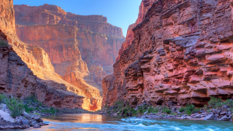
Cruising the Colorado River in a dory instead of a rubber raft may seem like a stately way to travel, but in reality it’s a much wilder ride, not very different from how John Wesley Powell and his team first navigated through the Grand Canyon bottom in 1869. Dories have evolved in design to be nimble and quick to swing around rocks and over rapids, but the boats tend to go through waves rather than over them like a raft would, making for exciting—and wet—adventures. Only a few outfitters are licensed to operate dories on the river. Trips range from five to 18 days, including all meals and riverside camping throughout the trip, and many book a year or more in advance.
Stargazing in Grand Canyon is an exceptional experience. The clarity of the night skies was recognized in summer 2019 when the park was officially designated as an International Dark Sky Park by the International Dark-Sky Association . In preparing for the recognition, the Park Service converted thousands of lights across the park to dark-sky compliant options. Not only does this afford guests a better view of the heavens above the cliffs, but it benefits wildlife that can be disrupted by artificial light . Every June, visitors can take advantage of star parties , with telescopes set up for free use, plus astronomer talks and photo workshops.

The Shoshone Point turnout doesn’t overlook the canyon—most cars whiz past it on their way to the money shot—but the relatively easy 2.2-mile trail from the parking lot to the edge is one of the least crowded along the popular South Rim. The view from the end is wonderful: well worth the moderate hike.
Hiking below the rim appeals to very few visitors to Grand Canyon National Park—less than 5 percent venture away from the top. But there are several spots that lend themselves to a quick dip down into the canyon to experience looking up at the walls, superb examples of the land’s reaction to weather over the millennia. One of them is the South Kaibab Trail . For those who don’t want to trek the six-plus miles to the canyon floor, Ooa-Aah Point about a third of the way down offers spectacular views.
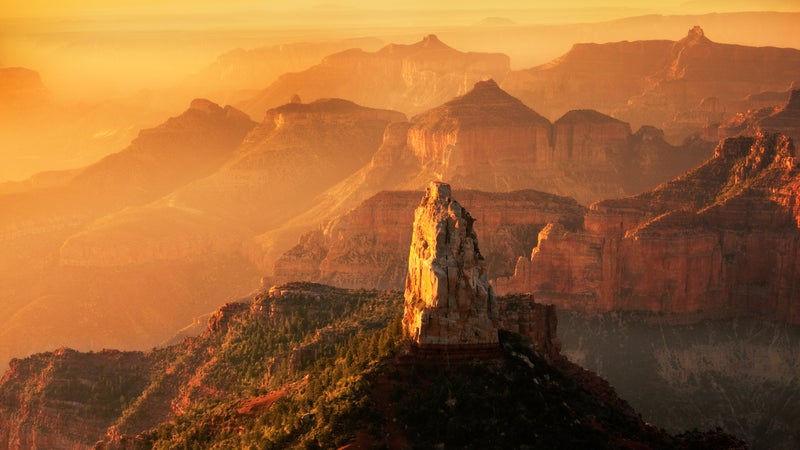
Toroweap Overlook, the North Rim’s most remote viewpoint of the canyon, is not for the faint of heart but it pretty much guarantees a unique experience. At the edge of the overlook is nothing but air; 3,000 feet down runs the largest rapid on the Colorado River. Ancient lava flows and black cinder cones invoke a time when volcanic eruptions sculpted the canyon into what we see now. Just getting to the overlook is a challenge; the road is unpaved and studded with rocks that require a high-clearance vehicle to drive. And if you’re looking to stay at Tuweep , the campground at the overlook, you’ll need a backcountry permit and plenty of preparation to stay in this area with no services.
Grand Canyon Village
With its exhibits on the park’s natural and human history, Grand Canyon Visitor Center on the South Rim is an excellent starting point. You can leave your vehicle there and walk or take a shuttle bus to other landmarks along the South Rim. Right behind the visitor center are Mather Point and the 13-mile Rim Trail to other stunning viewpoints like Yaki Point to the east and Yavapai Point to the west, where a geology museum illuminates nearly two billion years of canyon history.
Beyond Yavapai Point (1.3 miles) is the Village and the eclectic architecture of its historic structures, which together comprise a national historic landmark district. Many of the buildings were designed by pioneering female architect Mary Colter , including the distinctive Hopi House (1905), an homage to the indigenous architecture of the Southwest that now houses the park’s largest souvenir store and a Native American art gallery. Verkamp’s Visitor Center (1906) harbors a bookstore, information desk, and exhibits on the canyon’s pioneer history. Among other noteworthy structures are the Kolb Studio (1904) and Lookout Studio (1914), both vintage photo studios that now blend shopping and exhibit space.
The village train station (1910) is the terminus for the historic Grand Canyon Railway , a scenic passenger line that runs 64 miles through the pine forest and meadows of the Coconino Plateau between the South Rim and Williams, Arizona. Passengers can ride the train as a day trip to the Grand Canyon or combine it with overnights at South Rim lodging.
The South Rim
During the slower winter months, you can drive all the way to Hermits Rest. But during the busy peak season (March 1 to November 30), Hermit Road is closed to private vehicles west of the village. That leaves hiking and the shuttle bus as the two means to explore this awesome 7-mile stretch of the South Rim. “Must see” stops along the way include the Abyss with its 3,000-foot vertical drop-off and Pima Point , where you can see a slice of the milk-chocolate-colored Colorado River far below. At the end of the road, Hermits Rest is a faux frontier cabin (host to a gift shop and snack bar) fashioned by Colter in 1914.
- Nat Geo Expeditions
Grand Canyon aficionados debate which overlook along this stretch is best, from the aptly named Grandview Point to Moran Point with its view of Hance Rapids and Lipan Point, where you can gaze down on that big bend in the Colorado River. Tucked between the turnoffs is the small but interesting Tusayan Museum with exhibits on local Native American culture. Behind the museum, a short self-guided trail leads to the Tusayan Ruin , the remains of a 12th-century Puebloan village and one of 4,300 archaeological sites so far identified inside the national park.
Inspired by the Puebloan style, Colter fashioned the nearby Desert View Watchtower in 1932 as a perch for an even higher view down into the canyon. Eighty-five steps lead to an observation deck that sits more than 5,000 feet above the canyon floor, past murals of ancient Native American life rendered by Hopi artist Fred Kabotie . A snack bar, store, and gas station round out Desert View’s amenities.
The North Rim
From Desert View Tower, the drive to the Grand Canyon’s North Rim is nearly 200 miles. But it’s a journey into a different world. For starters, the North Rim averages a thousand feet higher than its southern counterpart. That may not seem like a lot, but that extra elevation makes a huge difference in climate, vegetation, and even the animals you come across. The North Rim is slightly cooler in the summer and often inaccessible during winter because of snowstorms. Tourist facilities are open only from May 15 to October 15.
The Visitor Center is a great place to start, especially if you plan on hiking the rim trails or driving the spur roads. Grand Canyon Lodge (1937) balances on the very edge of the chasm, and its back patio offers perhaps the best place in the entire park to sit, stare, and contemplate the geological wonder that spreads out before you. For an even more vertiginous view, hike the short (0.5-mile) trail to Bright Angel Point .
Scattered around the village are trailheads to paths including the 4.7-mile Uncle Jim Loop, the 9.6-mile Widforss Trail to a very secluded overlook, and the 9.8-mile Ken Patrick Trail all the way over to Point Imperial, the highest point on the North Rim, with views into the canyon’s northeastern corner. You can also drive to Point Imperial via Cape Royal Road, which switchbacks up onto the Walhalla Plateau and other celebrated panoramas like Vista Encantada and Angels Window. Adventurous drivers can test their mettle on the rough, unpaved road that leads out to Sublime Point, 18 miles west of the village. Four-wheel drive and high clearance are essential; a tow strap and saw (for cutting down fallen trees) are highly recommended.
Given the absence of roads, there are only three ways to explore the Grand Canyon below the rims: hiking, mule trips, and river flat trips.
Around 40,000 people a year backpack into the canyon for overnight stays that can vary from one night to several weeks. Far more people are day hikers who venture a short distance down one of three main trails for a taste of what it’s like to stare up at the imposing canyon walls.
Whether on a multi-day trek or an hour-long hike, walkers should always check out trail and weather conditions before plunging down the path. The most timely and accurate information is available from the national park visitor centers or the Backcountry Information Center on the South Rim.
Bright Angel Trail from the South Rim is the safest and best maintained route into the canyon and includes shade structures, emergency phones, toilets, and taps for refilling water bottles. With a trailhead just west of the South Rim Village, the Bright Angel dives quickly downward via a series of switchbacks to Indian Garden (4.8 miles) and a suspension bridge over the Colorado River to Bright Angel Campground (9.5 miles) and nearby Phantom Ranch. The route more or less follows a path that Native Americans and 19th-century prospectors took into the canyon.
The only path into the canyon from the opposite rim is the North Kaibab Trail , a 14-mile hoof down to Phantom Ranch and the river. Several trails wind through the canyon, including the rugged, multi-day Tonto Trail, which wanders 70 miles from east to west below the South Rim.
Mule trips into the canyon are offered from both rims. The South Rim features day trips and multi-day pack trips with stops at Phantom Ranch; the North Rim offers only rides.
WHERE TO STAY
Hotels South Rim Reservations: 888-297-2757 or grandcanyonlodges.com • El Tovar: Historic national park lodge opened in 1905 by the Fred Harvey Company; air conditioning, restaurant, bar • Bright Angel Lodge: Modern rooms and rustic cabins on the edge of the canyon, designed by Mary Colter in 1935; restaurant, saloon, soda fountain • Phantom Ranch: Very basic cabins and dorm rooms, and shared baths. It is the only indoor lodging at the bottom of the canyon; air-conditioning, restaurant; reserve up to 13 months ahead
North Rim Reservations: 877-386-4383 or grandcanyonforever.com • Grand Canyon Lodge : Cozy cabins and motel-style rooms on the North Rim; restaurants, bar; open mid-May to mid-October Camping Campground reservations: 877-444-6777 or www.recreation.gov • Three campgrounds: Mather at Grand Canyon Village (all year), North Rim (May 15 to October 15), and Desert View (mid-April to mid-October) • Trailer Village : RV campground with full hookups
Other things to see
• Havasu Canyon : Renowned for its waterfalls and aquamarine swimming holes, this sideshow to the main canyon lies inside the Havasupai Indian Reservation. Year-round camping and lodge. • Skywalk at Eagle Point : Perched 4,000 feet (1,219.2 m) above the canyon, this horseshoe-shaped glass walkway on the Hualupai Indian Reservation is the ultimate vertigo experience. • Bearizona Wildlife Park : Featuring both drive-through and walking portions, this nature reserve in Williams, Arizona, tenders close encounters with bears, wolves, bobcats, birds of prey, and other local animals. • Lake Mead National Recreation Area : One of the world’s largest reservoirs backs up behind Hoover Dam into the western end of the Grand Canyon. Overnight houseboat trips from Callville Bay Marina offer a unique perspective from down below.
Sixteen companies own concessions from the Park Service to run float trips down the Colorado River between Lees Ferry and Diamond Creek. A full list of river rafts is posted here .
Related Topics
- NATIONAL PARKS
You May Also Like

Everything to know about Zion National Park

Everything to know about Katmai National Park
Fuel their curiosity with your gift.

Everything you need to know about Everglades National Park

This new park gives different views of the Grand Canyon—with no crowds

How to visit Lake Clark National Park and Preserve

Hiking Kazakhstan: a day in Charyn Canyon National Park

4 remarkable wild stays in U.S. national parks, from a traditional log cabin to sky domes
- Perpetual Planet
- Environment
History & Culture
- History & Culture
- History Magazine
- Race in America
- Mind, Body, Wonder
- Destination Guide
- Paid Content
- Adventures Everywhere
- Terms of Use
- Privacy Policy
- Your US State Privacy Rights
- Children's Online Privacy Policy
- Interest-Based Ads
- About Nielsen Measurement
- Do Not Sell or Share My Personal Information
- Nat Geo Home
- Attend a Live Event
- Book a Trip
- Inspire Your Kids
- Shop Nat Geo
- Visit the D.C. Museum
- Learn About Our Impact
- Support Our Mission
- Advertise With Us
- Customer Service
- Renew Subscription
- Manage Your Subscription
- Work at Nat Geo
- Sign Up for Our Newsletters
- Contribute to Protect the Planet
Copyright © 1996-2015 National Geographic Society Copyright © 2015-2024 National Geographic Partners, LLC. All rights reserved
Grand Canyon National Park Travel Guide
Courtesy of Piriya Photography | Getty Images

Grand Canyon National Park Neighborhoods
The majority of the canyon's services and facilities – campgrounds, lodges, guided tours, etc. – are located on the popular South Rim. Because the Grand Canyon is a national park, be aware that there is an entrance fee. For private vehicles, the fee is $35 per vehicle. You can also enter on foot, by bicycle, by motorcycle or by free shuttle from nearby Tusayan and pay a $20 entrance fee per person. Keep in mind that visitors ages 15 and younger get in for free.
Once you enter the South Rim of the park, you'll see Grand Canyon Village , which holds the park headquarters and visitor center, the historic El Tovar Hotel , and a handful of local restaurants. You can explore the canyon from here using either West Rim Drive (Hermit Road) or Desert View Drive. Both are accessible by shuttle and private cars, except from March to November, when only shuttle buses are allowed. Desert View Drive follows the South Rim of the canyon for 26 miles, offering views of the canyon's rock formations. Yaki Point and Grandview Point are popular panoramic lookouts along the drive.
For a nice hike that affords great views of the canyon, walk along the Rim Trail , an easy, paved 12-mile trip that can be hiked at length or in short segments, and is accessible via the South Rim heading westward. In the summer and at various points along the trail, you can hop on the free South Rim shuttle bus.
You can also follow the Bright Angel Trail (on foot or by mule) from the Grand Canyon Village down into the canyon. This 12-mile round-trip trail offers close-up views of the Colorado River and the chance to experience the Grand Canyon from below.
The North Rim is far less crowded than the South Rim. But what the North Rim loses in services or facilities, travelers say it makes up in seclusion and the same great views. The Trans-Canyon Shuttle takes travelers from the North Rim to the South Rim for $90 each way per person. Because the park service does not operate snowplows on the North Rim, the area is closed from the first snowfall to mid-May. Some of the most popular highlights include Bright Angel Point and Point Imperial – the highest point on the North Rim. Point Sublime, located about 20 miles west of the North Rim Visitor Center, offers camping spots close to the canyon's edge. The road is only accessible to four-wheel-drive vehicles, and travelers should be equipped for wilderness travel. Camping also requires a backcountry permit .
Grand Canyon West
Grand Canyon West (located on the southern side of the Colorado River) is managed by the Hualapai Tribe. The Hualapai Indian Reservation is located on the southern side of the Colorado River, and lies outside the boundary and jurisdiction of the NPS. The tribe operates the Grand Canyon Skywalk , a glass walkway that extends over the side of the canyon for awesome views and photo opportunities.
Outside the Park
Not only will you save a little money by staying in one of the towns outside of the park, you'll also get a glimpse into the region's culture. Williams, Arizona, the southern terminus of the Grand Canyon Railway , offers inns, hotels, restaurants and gift shops for souvenir-seekers, as well as annual winter and fall celebrations. Even closer to the canyon, the town of Tusayan houses the popular IMAX Theatre Grand Canyon, which features a short film about the canyon. Also, several tour companies sell sky tours of the canyon. Tusayan also offers a number of gift shops with affordable and high-end goods, some of which are handmade by local Native American tribes.
Nearby Native American reservations offer travelers a glimpse of the area's indigenous culture and history. On the south side of the Colorado River just outside of NPS-administered grounds is the Havasupai village of Supai. Located near Havasu Falls , Supai is accessible only by hiking or horseback. To inquire about hiking permits and campground reservations, see the Havasupai website.
Popular Grand Canyon Trails
Rim Trail (Accessible from Grand Canyon Village, along the South Rim.)
One of the most popular trails in the park, the north and south extensions of the 12-mile-long Rim Trail offers spectacular views of the canyon while remaining relatively easy on the feet. Here, tourists can walk on smooth ground while admiring their surroundings.
Bright Angel Trail (Accessible just west of Bright Angel Lodge, along the South Rim.)
The Bright Angel Trail is a great scenic trail to hike to the bottom of the canyon, but beware: It's an approximately 12-mile hike round trip. Avoid making the full trip during the summer, as you may put yourself at risk of heat exhaustion. Still, there are shady spots along the trail and rest houses that provide water for thirsty hikers.
South Kaibab Trail (Accessible at Yaki Point, off of Desert View Drive, along the South Rim.)
If you're feeling extra adventurous, the 6-mile-long South Kaibab Trail is a more daring alternative to the nearby Bright Angel Trail . While the trail is steeper and lacks the shade and frequent rest stops of Bright Angel, many visitors say the South Kaibab Trail is more scenic. Be sure to bring plenty of water, especially if you're hiking in warmer temperatures.
Plateau Point Trail (Accessible via Bright Angel Trail, along the South Rim.)
Plateau Point Trail is arguably the best day hike below the rim. The trail runs 12.2 miles round trip through the Bright Angel Trail .
North Kaibab Trail (Accessible two miles north of Grand Canyon Lodge, along the North Rim.)
North Kaibab Trail is best for those trying to avoid the crowds on the South Rim. You can camp at the Cottonwood Campground halfway along the trail.
The greatest safety concern in the Grand Canyon is the outdoors. It is not advisable to hike or camp alone in the park, even if you know the canyon very well. Even experienced hikers have become lost in the park because they were not well-acquainted with certain trails, which can prove to be dangerous. Be sure to bring an adequate amount of water for your trip and wear sunscreen. Also check the weather before hiking, since lightning during summertime thunderstorms can be deadly.
Encountering wildlife can present another danger. The park service advises travelers keep a distance of at least 100 feet (or about two bus lengths) away from the park's larger animals, such as elk, deer, bighorn sheep, California condors and mountain lions. As for smaller animals, such as squirrels, birds and reptiles, visitors should stay at least 50 feet (about one bus length) away.
The Grand Canyon is a relatively safe park in terms of crime. If you park your car within the canyon, be sure to lock your vehicle and safeguard any belongings just in case. For more information, see the National Park Service's website .
Explore More of Grand Canyon National Park

Things To Do

Best Hotels

When To Visit
You might also like

# 1 in Best Party Cities in the U.S.

# 2 in Best Day Trips from Phoenix

# 5 in Best Day Trips from Phoenix
If you make a purchase from our site, we may earn a commission. This does not affect the quality or independence of our editorial content.
Recommended
The 28 Best Water Parks in the U.S. for 2024
Holly Johnson|Timothy J. Forster May 8, 2024

The 18 Best Napa Valley Wineries to Visit in 2024
Lyn Mettler|Sharael Kolberg April 23, 2024

The 25 Best Beaches on the East Coast for 2024
Timothy J. Forster|Sharael Kolberg April 19, 2024

The 50 Best Hotels in the USA 2024
Christina Maggitas February 6, 2024

The 32 Most Famous Landmarks in the World
Gwen Pratesi|Timothy J. Forster February 1, 2024

9 Top All-Inclusive Resorts in Florida for 2024
Gwen Pratesi|Amanda Norcross January 5, 2024

24 Top All-Inclusive Resorts in the U.S. for 2024
Erin Evans January 4, 2024

26 Top Adults-Only All-Inclusive Resorts for 2024
Zach Watson December 28, 2023

Solo Vacations: The 36 Best Places to Travel Alone in 2024
Lyn Mettler|Erin Vasta December 22, 2023

26 Cheap Beach Vacations for Travelers on a Budget
Kyle McCarthy|Sharael Kolberg December 4, 2023

SUMMER GETAWAY IDEAS?
New! Find answers in a flash with Scout, our friendly AI chat otter.
BEST WEEK EVER
Try out unlimited access with 7 days of Outside+ for free.
Start Your Free Trial

The Ultimate Guide to Grand Canyon National Park
Grand Canyon National Park has some of the best views in the United States. Here’s how to make the most out of a visit, whether its hiking, boating, biking, camping, or so much more.
Heading out the door? Read this article on the Outside app available now on iOS devices for members! >","name":"in-content-cta","type":"link"}}'>Download the app .
No wonder Teddy Roosevelt called the Grand Canyon “the one great sight which every American should see.” Walk to its edge, and the earth falls away into an expanse of peaks, plateaus, and gorges so vast it can be disorienting. Descend below the rim, and the sense of awe only grows. The canyon is essentially an inverted, 6,000-foot, 277-mile-long mountain range, where you are dwarfed by sheer stone walls stacked to the sky and vistas that multiply with every turn. In the desert landscape, the water can be the most astonishing sight. Turquoise streams rush whole out of rust red cliffs and cascade through travertine pools. At the bottom of the canyon, of course, lies the engine of this great geological conundrum—the thrumming, persistent Colorado River , which carved the gorge over millennia. If there’s a better place to gain perspective on our own relative insignificance, I don’t know it.
But all this comes with a downside. The park gets crowded. More than 4.5 million people visited in 2021 alone. Don’t let that stop you from planning a trip, though. Just a fraction of visitors bother to descend into the canyon itself, which means it’s easy to find solitude. But with 595 miles of established trails, 278 miles of river to float, and countless panoramas, historic sites, and overlooks to explore, it’s hard to know where to start. Here’s how to make the most out of an adventure to one of our country’s most rugged and iconic places.
What You Need to Know Before Visiting the Grand Canyon
Beware of the heat.
The interior of the canyon averages triple-digit highs June through August, and those temperatures contributed to 82 rescues in 2017 alone. So unless you’re a reptile or riding in a raft, plan your visit for the other nine months of the year.
If a summer trip is your only option, head to the North Rim.
The North Rim gets about a tenth of the visitors and, at an elevation of 8,297 feet, runs nearly ten degrees cooler than the South Rim. In fact, all park amenities on the North Rim are closed November through April, and the road into the park closes in December—or earlier if enough snow falls—meaning you can only access the North Rim by hiking, snowshoeing, or cross-country skiing with a backcountry permit.
Be prepared for some paperwork and hope for some luck.
Many of the park’s best adventures, like camping in the backcountry, running your own trip down the Colorado’s rapids, or spending the night at the Phantom Ranch at the canyon’s bottom, require winning a lottery to land the necessary permits.
Rafting Permits in Grand Canyon National Park
If you know your way around an oar rig, the odds of winning a permit for a noncommercial river trip are notoriously difficult, especially for popular times like autumn and spring. For example, there were 459 applications to launch on September 18, 2019, alone. On the other hand, some days in December, when the days are short and the nights are cold, see no applicants at all. No matter your launch date, it costs $25 to apply for a permit. If you win, a $200 to $400 deposit must be paid immediately and is applied to your trip’s final price tag, which will depend on the size of your group.
Backpacking Permits in Grand Canyon National Park
Your odds for scoring overnight backpacking permits are much better and only cost $10 per permit, plus $12 per person per night in the canyon or $12 per group above the rim. A word of note on this, though: the park’s reservation system is still dependent on pre-Y2K technology, meaning you have to apply via fax, regular mail, or in person. Your best chance for landing your dream hike is sending in a written application a little over four months before your planned trip during what’s called the earliest consideration period, which starts on the 20th of every month and runs through the first of the next. Trip applications submitted during this time are rewarded through a lottery. After that it’s first-come, first-served. Don’t fret if you don’t snag the spot you want, and definitely don’t cancel your trip. Most people don’t know it, but once you receive your permit, you can call the backcountry office to try and modify it. The nonprofit Grand Canyon Trust has a good explainer of the byzantine system here .
How to Get There
Grand Canyon National Park is split into two distinct zones divided by, well, the actual canyon. It’s a long four-and-a-half-hour drive to get from one rim to the other, so plan carefully. If you’re visiting the North Rim, it’s quickest to fly to Las Vegas, a four-and-a-half-hour drive from the park. If you are bound for the South Rim, from Phoenix it’s a three-and-a-half-hour drive, or you can splurge on one of the few daily flights into Flagstaff, Arizona, just an hour and a half south of Grand Canyon Village, the main hub for exploring the park. No car, or prefer not to drive? Groome Transportation runs vans from Flagstaff to the village three times a day from May 15 to October 16.
Where to Stay In or Near the Grand Canyon
Outside Inc.’s National Park Trips offers a free Grand Canyon Trip Planner filled with a complete itinerary, beautiful photography, a park map, and everything else you need to plan your dream vacation.
El Tovar is a landmark, not only for its location just steps from the canyon rim but also for its iconic architectural style, which influenced many of the National Park lodges that followed. Built in 1905, it’s worth taking a look at the log-sided lobby, even if you aren’t staying there. Like most NPS lodging, rooms are basic, expensive, and hard to come by (from $394). You’ll want to book a year in advance, especially if you covet one of the three balcony suites on the canyon side, which cannot be reserved online. You’ll have to call the hotel directly, and they’ll cost you double the regular room rate. There are five other hotels on the South Rim , all pretty basic, and another half dozen in the town of Tusayan, just outside the park, about six miles from the rim.
For camping on the South Rim, your best bet is to head 25 miles east of Grand Canyon Village for the prized sunsets at Desert View Campground . It runs $18 per night but is first-come, first-served, so plan to snag a site midmorning when campers are clearing out.
Go for the Western Cabins at the Grand Canyon Lodge . With nothing between your front porch and the canyon but a few pine trees, cabins 301, 305, 306, and 309 are some of the best accommodations in the park ($271, open May 15 to October 15). If those are booked, grabbing an Adirondack chair from the main lodge’s veranda and settling in as the sunset washes the Deva, Brahma, and Zoroaster Temple buttes in flaming alpenglow is a solid second choice.
You can catch the same west-facing views at the North Rim Campground , a mile or so north of the lodge. Book sites 14 to 19, right on the rim, if you can, though they’re often reserved a year in advance.
Canyon Floor
The Phantom Ranch, tucked into a shady cottonwood grove at the bottom of the chasm, switched its reservation system to a lottery in 2018, and entries are due a whopping 15 months ahead of your desired dates. If you don’t make the cut, try for a spot at the adjacent Bright Angel Campground, which requires a backcountry camping permit. You can still order meals from Phantom Ranch, which will lighten your load for the hike in.
The Best Adventures in Grand Canyon National Park
Most park visitors never leave the developed enclave of Grand Canyon Village on the South Rim. They roll up in their rental car, park, stroll to the guardrail rim, browse the gift shops, and then head to the next national park on their checklist. That’s not an exaggeration: the park estimates that the average visit lasts less than four hours. Even hopping on the free shuttles that stop for fresh views along the South Rim every mile or so is enough to leave most of the horde behind. The farther you get from the visitor center, the more the crowds thin out.
Biking Routes
Rent bikes from Bright Angel Bicycles , located next to the visitor center, and cruise the South Rim. The Hermit Road winds seven miles along the rim from the village and is closed to private cars March through November, making it one of the most scenic cycling paths in the world. Or head east from the visitors center and link the bike path with the car-free Yaki Point Road. Jutting far into the canyon, Yaki Point is a popular spot to catch the sunset splash rosy light across a 42-mile swath of canyon all the way from the Palisades of the Desert, 25 miles to the east, to Havasupai Point, 17 miles west.
Hiking Trails
For day outings, skip the South Rim’s well-trampled Bright Angel Trail, which drops into the canyon right at the village, and take the shuttle bus from there to the South Kaibab Trailhead. The seven-mile path, one of the best hiking trails in Grand Canyon National Park, descends 4,780 feet all the way to the river, but many people merely opt for the 1.8-mile round-trip to the comically named Ooh Aah Point. On the North Rim, the mild five-mile Widforss Trail winds along the rim and then ducks through ponderosa pine and aspen groves to Widforss Point, where you can catch views of sheer, jagged buttes like Wotans Throne and the Zoroaster Temple or the battlements of Transept Canyon.
Backpacking Trips
The remote, arduous Thunder River Trail may well be the Grand Canyon’s most astonishing backpacking trip. Start the 21-mile, three-day loop from the Bill Hall Trailhead at Monument Point (which shaves 2.5 miles off the traditional Indian Hollow Trailhead route), 34 miles down a sometimes impassable road from the North Rim town of Jacob Lake. It passes by Thunder River itself, a large creek that pours straight out of cave midway up the red canyon wall and tumbles down tiers of lush, vegetated pools. Don’t miss the chance to spend an afternoon exploring the twisting Deer Creek Narrows, or detour down the rafter’s trail to the river to check out the outlet of the narrows, 80-foot-high Deer Creek Falls.
The granddaddy of Grand Canyon hikes is going rim to rim, dropping all the way to the river, crossing the bridge at Phantom Ranch, and then climbing out the other side. Some break up the journey with a night at Phantom Ranch. Others prefer to knock it out in a day—the current record is two hours and 39 minutes. To preserve knee cartilage, most people start at the lower South Rim, descend 4,460 feet on the Bright Angel Trail, and then ascend 5,850 feet on the North Kaibab Trail to the North Rim Lodge, for a total of 21 miles. Some of the more ambitious hikers and runners go rim to rim to rim , but for the one-way trip, you’ll need transportation back. If you can’t talk a friend into picking you up on the other side (a four-and-a-half-hour drive one-way), you can drop a car off yourself and catch a ride back with the Trans-Canyon Shuttle for $120.
Boating and Paddling
There are two ways to boat the Colorado River: by motorized raft or in a human-propelled oar or paddle raft. I can’t recommend the former. The outboard engines feel like a violation of the river’s stretches of sublime silence, and the huge 30-foot rafts—packed shoulder to shoulder with passengers—mute even the formidable whitewater.
The best way to experience the river is at its own pace, taking on the towering waves of famous rapids like Crystal and Lava Falls in an 18-foot oar rig. You’ll drift for days through face-melting scenery, blast down hundreds of galloping rapids, and camp each night on sand beaches beneath a lane of bright stars. Plus you can pack steaks and fresh veggies in coolers, chill beers beers in drag bags in the river, and best of all, enjoy the complete lack of cell-phone reception. If you don’t have the experience or a permit to DIY, more than a dozen commercial companies including OARS and AZRA run river trips through the Grand Canyon, ranging in length from three to 18 days and costing around $2,000 to $6,000.
Where to Eat and Drink Near the Grand Canyon
If you’re driving up from Phoenix, stop in Flagstaff, a college town with a burgeoning food and brewery scene. For lunch, pop by Diablo Burger for locally sourced beef patties served on English muffins, and grab a Blake, which features homemade Hatch-chile mayo, roasted green chilies, and sharp cheddar. Staying for dinner? The folks at Satchmo’s say their fare is good for the soul—cast-iron cornbread, jambalaya, and slow-smoked barbecue are all on the menu.
Inside the park, dining options are mainly limited to large-scale concessionaires who win service-contract bids. Xanterra , which runs most of the Grand Canyon’s restaurants, now sources 40 percent of its ingredients from sustainable or local vendors. At the El Tovar dining room, the signature prime-rib hash—which features Arizona-grown beef, cage-free eggs, bell peppers, and chipotle hollandaise sauce—should set you up for a descent into the canyon and back.
Bright Angel Bicycles in Grand Canyon Village sells Flagstaff-made baked goods, sandwiches, and coffee. The cinnamon pound cake is worth stashing in your pack for a midride snack.
Across the canyon, the view from the veranda at the Grand Canyon Lodge makes for some of the best alfresco dining on the planet. From the dinner menu, try the wings, which are braised in spicy prickly pear cactus juice. Wash it down with Flagstaff-brewed beers named after park features, like the Phantom Ranch Red.
Just outside the park, the Meadows Edge Coffee Trailer, beside the North Rim Country Store , serves a blueberry-pomegranate smoothie and the canyon’s best latte. A little farther on, at the junction of 89A and Highway 67, the Jacob Lake Inn is famous for its cookies . There are 15 varieties on offer, including chocolate parfait and lemon zucchini with pecans.
If You Have Time for a Detour
While getting a permit to float through the Grand Canyon takes some doing, paddling 15 miles upstream from the park into Marble Canyon requires no permits, fees, or reservations. Dogs are also allowed, so you can finally let the pups out of the van.
For camping, part of Glen Canyon National Recreation Area (the section of river between Lee’s Ferry and Glen Canyon Dam) contains first-come, first-serve sites. Or relatively strong paddlers can rent a kayak from Hidden Canyon Kayak in nearby Page, Arizona, and head upstream to camp in the Instagram mecca that is Horseshoe Bend . From the beach, you can just make out the silhouettes of the hordes on the rim.
Want to mountain bike at the park? You can’t. But the Rainbow Rim Trail , on Forest Service land abutting the North Rim, has become the go-to destination for fat-tire riders wanting to cozy up to America’s favorite abyss. Twenty-two miles of singletrack wind through ponderosa pine forests and meadows, occasionally popping out at the rocky rim for eyefuls of the Big Ditch. Most cyclists post up for a few days at dispersed car-camping spots like Locust Trailhead, midway on the route.
Editor’s Note: We frequently update this National Parks guide, which was originally published on Dec 4, 2018.
- Grand Canyon
9 things in Grand Canyon National Park that no one should miss

Apr 1, 2024 • 5 min read

An unmissable experience: rafting on the Colorado River in the Grand Canyon © Merrill Images / Getty Images
At every majestic red, brown and pink turn, Grand Canyon National Park wows, with nature’s utmost beauty on full display.
The Grand Canyon is a global destination that offers more than 1.2 million acres of rocky, woodsy and riverine landscapes. It’s a paradise that appeals to travelers in search of many sorts of excursions, from family-centric outings to the most challenging of hikes.
Geologic forces have been molding this scenery for millions of years – and how you choose to take it all in, and which activities you opt for, will define your impression of this natural icon. The Arizona park features more than 130 trails, plus museums to explore, lodges to cozy into and water activities to enjoy.
Amid the many options, here are the top things to do in Grand Canyon National Park.

1. Take the train to the South Rim via Grand Canyon Railway
Getting to the Grand Canyon is half the fun. Sure, you can embark on a desert journey from Las Vegas via car, or weave through towering hardwoods en route from Flagstaff . However you choose to arrive, consider completing the last leg via the Grand Canyon Railway . With daily routes from Williams, Arizona – approximately 60 miles south of Grand Canyon Village – the railway provides the perfect hybrid of desert and forest landscapes. And it’s always a hoot onboard, with Western-inspired entertainment that the whole family will enjoy.
Planning tip : The train departs Williams at 9:30am daily and returns at 3:30pm (with the exception of November and December). This schedule leaves you approximately three hours and 45 minutes at the canyon.

2. Absorb the canyon’s majesty from several viewpoints
You can plausibly argue that every step in Grand Canyon National Park provides a memorable viewpoint. Yet a handful of lookouts within the park long the South Rim’s main drag (Desert View Dr / Rte 64) – easily accessible to all, and all with guardrails – truly stand out. These include the primed-for-a-sunset Mather Point , partially paved Mohave Point and Grandview Point , from which you can see a bend in the Colorado River below.

3. Admire landscape-inspired art at Kolb Studio
Grand Canyon National Park is a piece of art in itself, true – yet there is an actual art studio within its limits, too. Situated on a cliff along the South Rim, Kolb Studio was once a family residence and photo studio. Today, the multi-level cabin boasts vintage photos from its namesakes – brothers Ellsworth and Emery Kolb – as well as paintings and portraits of folks exploring the canyon’s acreage in times past.

4. Take a hike along Bright Angel Trail or South Kaibab Trail
Once you lace up your hiking boots, everything from a death-defying, drop-filled, 11-mile jaunt (the Nankoweap Trail) to a flat straight shot to panoramic vistas ( Shoshone Point ) awaits. Yet the quintessential trails at the Grand Canyon – each containing a range of difficulties along them – are the nearly 8-mile Bright Angel Trail and the 6-plus-mile South Kaibab Trail . They’re both located in the South Rim , and provide stunning lookouts (such as Ooh Aah Point on South Kaibab) as they descend into the canyon.
Planning tip : The park is open 24 hours a day, 365 days a year, with its busiest hours from 10am to 4pm. Arrive early (or late) to avoid the crowds.

5. Check into Phantom Ranch or another woodsy in-park lodge
The only lodging option below the canyon rim, Phantom Ranch is nestled alongside Bright Angel Creek, just a half mile from the banks of the Colorado River. On its grounds, visitors can check into one of 11 cabins as well as single-sex dormitories. (Reserve early, as accommodations typically book up months in advance.) Beyond Phantom Ranch, a handful of above-rim lodges lie within the park, including the Maswik Lodge South , which opened in 2022; Charles Wittlesey-designed El Tovar ; and the contemporary, cement-draped Kachina Lodge .

6. Kayak curvy Horseshoe Bend
You guessed it: Horseshoe Bend is sheer sandstone wizardry, sculpted by nature in the form of its namesake. Dipping more than 1000ft to the Colorado River below, the trailhead to this popular attraction is located just south of the town of Page. While the trail itself provides 1.2 miles of sweeping beauty, opt for a kayak adventure for a bottom-to-top perspective. Companies like Kayak Horseshoe Bend and Kayak the Colorado have the goods – and, if desired, the guides – to make it happen.
Detour : For more boating adventures, head 15 minutes north to Lake Powell, where operators like Lake Powell Boat Tours offer excursions.

7. Go white-water rafting on the Colorado River
There are few things more refreshing than a hearty splash of Colorado River water after a trek through an often blazing-hot canyon. Go for more than just a quick dip and make a day out of it with a rafting trip. April through October are the best months for rafting, and companies like Grand Canyon Expeditions know exactly where to take thrill seekers and tranquil floaters alike.
Planning tip : Beyond half-day and full-day adventures, three- to five-day rafting and boating trips can take you to the canyon all the way from Las Vegas. Advantage Grand Canyon is a comprehensive site that has a list of all your rafting choices.

8. Take in layered vistas with a bike ride along the South Rim Trail
Between driving, hiking and strolling the viewpoints, add in a bike ride for a full canyon experience. Along the South Rim, a wonderfully paved, 13-mile route offers canyon vistas with every rotation of the pedals. Bikes and e-bikes are now permitted in the park; if you left yours at home, Bright Angel Bicycles and GC-Bikes are tucked near the rim in Grand Canyon Village, with offerings for both adults and kids.
Local tip : When you tire, the park’s shuttle-bus system has bike racks. The shuttle stops almost every mile of the 13-mile stretch, and runs every 15 to 30 minutes.

9. Don’t forget a North Rim excursion
The bulk of the Grand Canyon’s buzziest spots – Bright Angel Trail, Desert View Watchtower and the Trail of Time being among them – are found at the South Rim. But let’s not forget the generally more remote and less developed North Rim . Some of the best viewpoints in all of this part of the Southwest are to be found here, including Cape Royal and Point Imperial .
Planning tip : The North Rim is open May 15 through December 1 annually, and is otherwise closed to vehicular traffic.
This article was first published Jan 25, 2023 and updated Apr 1, 2024.
Explore related stories

Feb 16, 2023 • 6 min read
From witnessing huge icebergs break off to close-ups of the Statue of Liberty, these are the best national park experiences in the USA for 2023.

Jun 10, 2022 • 4 min read

Nov 4, 2021 • 7 min read

Oct 8, 2021 • 6 min read

Sep 23, 2021 • 7 min read

Sep 14, 2021 • 6 min read

Sep 8, 2021 • 7 min read

Jan 22, 2021 • 4 min read

Nov 25, 2020 • 5 min read

Feb 28, 2020 • 6 min read
USPS suggests the address below
Arizona map, time to upgrade your browser.
If you're reading this, you're surfing using Internet Explorer 6, an eight-year-old browser that cannot cope with the demands of the modern, secure internet. For the best web experience, we strongly recommend upgrading to Firefox , Opera , Safari , Google Chrome , or a more recent version of Internet Explorer .
- Grand Canyon NP Links
- Grand Canyon NP Introduction
- Orientation
- Nearby Destinations
- Statewide Links
- Arizona Destinations
- Visit Other States
- Visit Other Countries
A summary of what Grand Canyon NP has to offer.
Detailed overview for Grand Canyon NP, with custom maps, points of interest, and helpful things to know before you go.

Dramatic canyons and red ochre cliffs lend the city of Sedona a setting that's hard to lightly dismiss, though this popular destination does well to distract with its downtown offerings.
- Tour Companies
- Tourist Attractions
- Sightseeing Opportunities
- Recreational Activities
- Things To Do - Overview
- Attractions
- Scenic Drives
- Scenic Flights
- Sightseeing Tours
- Free Travel Planners
- Adventure Trips
- Balloon Flights
- Bird Watching
- Horseback Riding
- Houseboating
- Offroad - ATV
- Climbing / Canyoneering
- RV Parks Camping
- Scuba - Snorkel
- Skiing - Boarding
- Snowmobiling
- White Water Rafting
- X-Country Skiing
- Spas & Wellness
Searchable list of Grand Canyon NP tour companies, guides and outfitters, rental companies and more.
Full information on Grand Canyon NP Tourist Attractions, Scenic Drives and other easy vacation activities…
- Houseboat Rentals
- Whitewater Rafting
- North Rim Details

- Lodging - Hotels, Resorts, etc.
- RV Parks - Campgrounds
- Restaurants
Searchable listings of Grand Canyon NP hotels, motels, resorts, bed & breakfast, and more.
Searchable listings of Grand Canyon NP RV parks and campgrounds.
Searchable listings of Grand Canyon NP restaurants, bars, diners, and more.

Use our easy Lodging Search to find exactly the type of accommodation you are looking for at the right price.
- Free Visitor Guides!
- Transportation
- Tourism Resources
- State Facts
Request Free Travel brochures for Grand Canyon National Park.
Travel articles related to Grand Canyon National Park…
Transportation companies, driving directions and more for Grand Canyon NP.
Grand Canyon NP weather report, historic temperatures and climate info,…
Searchable lists of Grand Canyon NP tourism offices and other helpful government agencies.
Explore destinations near Grand Canyon National Park.

- Grand Canyon NP Photo Gallery
- Grand Canyon NP Video Gallery
- Arizona Photo Gallery Arizona Video Gallery

- Connecticut
- Development
- Massachusetts
- Mississippi
- New Hampshire
- North Carolina
- North Dakota
- Pennsylvania
- Rhode Island
- South Carolina
- South Dakota
- Washington D.C.
- West Virginia
Free Grand Canyon NP Area Travel Planners
Request free travel information for grand canyon np, arizona.
- Introduction
- Sightseeing Overview
- Recreation Overview
- Offroad - ATV - UTV
- Free Travel Planners >
- Photo Gallery
- Video Gallery
Like most tourism destinations, Grand Canyon NP, Arizona provides free pamphlets and brochures to visitors, highlighting the sights and activities of Grand Canyon NP. Usually you have to find a visitor's center to get them, subject to business hours. Go-Arizona.com is pleased to offer these materials by mail and e-mail for free thanks to our local travel board affiliates.
Your planner will include everything you need to know about local attractions, events and history, as well as complete information on shops, restaurants, lodging and more. You'll get colorful photography and descriptions written by locals who live in and love the area.
If you have additional questions after you receive your travel planner, call the number in the planner and they will be happy to assist you.
Select the areas you're interested in below. Pick as many as you like, these guides are completely free and incredibly helpful for planning your vacation.
Grand Canyon National Park Travel Planners
Search grand canyon national park travel planners.
Select All Click on Travel Planner cover to select. Click the name for more information.
5 travel planner Result s
More info arizona state parks.
- AZ_State_Parks_Oct_2023_2_39571_39302.jpg
- State of Arizona
- General Interest

More Info Official Website Arizona - The Grand Canyon State
- stateOfArizona_2023_14110_20465.jpg
Start planning your Arizona vacation with the Official State Visitor's guide - available in print, electronically, or both. Fill out the form to request your free travel packet, which includes an Arizona Official State Visitor's Guide and an Arizona state highway map. The Arizona Office of Tourism ships domestically as well as the following countries only: United Kingdom, Germany, France, Japan, Canada and Mexico.
More Info Official Website Bryce Canyon Country
- Garfield-County-Tourism-Office-Address-2014_87948_32334.jpg
- Southern Utah

More Info Official Website Zion National Park - North Rim Grand Canyon
- Kane-County-Travel-Council-Address-small_63990_93862.jpg

More Info Maverick Helicopters
- Maverick-Helicopters-Las-Vegas-Brochure-front-page_63074_7179.jpg
- Nevada, Arizona, Hawaii, and California
- Specialty Guide
Unforgettable Tours Offered in Nevada, Arizona, Hawaii, and California.
Request Your Free Visitor Guides
After selecting one or more FREE Visitor Guides from the list above, please complete and submit the form below.
Your request has been processed, thank you!
We also have the following visitor guides in Arizona. Click on any additional guides you would like to receive. Your submissions were successful, thank you! ' )); tpsButtonClicked.closest( 'div.popup' ).hide( ); $('#before-Dest-State-Travel-Planners').hide();$('#after-Dest-State-Travel-Planners').show(); } ); ">Request these additional visitor guides selected below

Zion National Park - North Rim Grand Canyon Southern Utah
Zion national park - north rim grand canyon.

San Juan County Southeast Utah
San juan county.

Capitol Reef Country Central Utah
Capitol reef country.

Sierra Vista Southern Arizona
Sierra vista.

Tucson Southeast Arizona

Glendale Phoenix Area - Central Arizona

Wickenburg Central Arizona

Bisbee Southern Arizona

Lake Havasu City Western Arizona
Lake havasu city.

Tempe Phoenix Area - Central Arizona

Arizona - The Grand Canyon State Arizona
Arizona - the grand canyon state.

Bryce Canyon Country Southern Utah
Bryce canyon country.

Benson Southeast

Utah - Life Elevated Statewide
Utah - life elevated.

Prescott: An Arizona Gem Central Arizona
Prescott: an arizona gem.

Chandler Phoenix area - Central Arizona

Discover Gilbert Phoenix Area
Discover gilbert.

Discover Salt River Scottsdale Area
Discover salt river.

Explore Cochise County Southeast Arizona
Explore cochise county.

Superior Southeastern Arizona

Cottonwood Central Arizona

Williams Northern Arizona

Town of Clarkdale North-Central Arizona
Town of clarkdale.

Arizona State Parks State of Arizona
Arizona state parks.

Douglas, Arizona Southern Arizona
Douglas, arizona, specialty guides.

Maverick Helicopters Nevada, Arizona, Hawaii, and California
Maverick helicopters.
We also have visitor guides available in states highlighted in blue below. Click on any state to see what's available.
- Advertising
- Privacy Policy
- Report a Problem
- Make A Suggestion

- Go Travel Sites
- Houseboating.org
Email Page Link
Switch to Mobile Browser Mode
We offer a compact version of Go-Arizona for mobile users, allowing you to access just the information you need on the road. Of course, you can still use the full version of Go-Arizona on your mobile device just as you can on your desktop.
Continue to Mobile Site Return to Main Site


10 Things To Do In The Grand Canyon Region: A Comprehensive Guide To Discovering The Wild West
W hether travelers have already visited the Wonder of the World, they're afraid it will be too crowded, or they're looking for things to do on the way there and back, there are plenty of reasons to explore what else to do around the Grand Canyon. While on the map the region may just look like a desert, the areas of northern Arizona, southern Utah, and southeastern Nevada are rich with opportunities to add more excitement to any road trip.
After enjoying everything to do at Grand Canyon National Park , vacationers will be thrilled to learn there's a lot not to miss in the surrounding area. A large swath of the region is composed of the Navajo Nation, crisscrossed by scenic and iconic highways and dotted with colossal lakes, towns and cities, and yes, even more mesmerizing canyons to experience and explore. From Arizona road trips along Route 66 to endless water sports, hiking, and outdoor escapades, this guide will break down all the other things people can do near the Grand Canyon.
Discover where tourists flock, push the travel itinerary beyond the ordinary at iconic destinations, and unveil the best-kept secrets around the Grand Canyon below.
Related 10 Bucket List Things For Couples To Do At The Grand Canyon
Top Things To Do
While it's one of the Wonders of the World, there are so many other things to do near the Grand Canyon, including water sports and outdoor activities at two of the United States' largest reservoirs, nostalgic towns, and roadside attractions along Route 66, and, believe it or not, exploring even more canyons in Arizona . Find out below where tourists go and what to see near the Grand Canyon.
Go Whitewater Rafting At Peach Springs
Just two hours from the West Rim, Peach Springs, Arizona is a great place to find other things to do around the Grand Canyon. The tiny town is known for its exhilarating outdoor experiences, most notably its thrilling whitewater rafting adventures.
Peach Springs is one of the best places in the United States for whitewater rafting ; thrill seekers can brave the Colorado River snaking through stunning natural surroundings and take on challenging rapids like Hualapai or Diamond Creek.
Hualapai River Runners is a reputable whitewater rafting tour company , offering one or two-day excursions from Peach Springs with certified guides. These guides additionally provide a glimpse into the local culture and traditions of the Hualapai tribes.
- One-Day Rafting Tour Prices: from $400 per person
- Two-Day Rafting Tour Prices: from $800 per person
- Note: Tours are available from March through October
Unwind At Lake Mead
Is it a mirage in the Arizona desert or is it Lake Mead? Some four hours west of the Grand Canyon and near the Hoover Dam and Las Vegas, Lake Mead is a tranquil oasis and the United States' largest reservoir. After long days of hiking (or long nights of gambling), Lake Mead beckons visitors seeking relaxation, offering them the chance to sit back and take a breath.
Apart from several resorts, spa centers, and lakeside restaurants lining the reservoir, Lake Mead's expansive and stunning landscapes make it a haven for outdoor enthusiasts. Some of the most notable recreation activities in the area include:
Roadtrippers looking for what else to do around the Grand Canyon should check out these fun facts about Lake Mead and then plan their next hiking, kayaking, or horseback riding adventure.
Related Upright Shipwrecks & More: 10 Unusual Things Discovered At Lake Mead
Visit The Coral Pink Sand Dunes In Kanab, Utah
For an unforgettable and mesmerizing experience north of the Grand Canyon, travel to the Coral Pink Sand Dunes . These rolling coral-tinted dunes in southern Utah offer psychedelic views of the desert, a natural wonder perfect for hiking, sand boarding, photography, or dune buggies.
As a popular tourist attraction, the entrance to the state park is controlled, but nature lovers can't miss the chance to explore this scenic attraction near the Grand Canyon.
- Park Entrance: $10 per vehicle per day
- Campgrounds : from $25 per night
- Park Hours: Daily, sunrise - sunset
Visit Kanab after a day at the Coral Pink Sand Dunes. The small town is a hub for outdoor adventures in Utah and Arizona and is also known as 'Little Hollywood' due to all the westerns shot in the area.
Make A Trip To Bearizona
Make the fascinating drive through the 160-acre Bearizona Wildlife Park near Williams, just off Route 66 and south of the Grand Canyon. The family-friendly attraction allows visitors to drive a three-mile loop through the park to witness free-roaming wildlife areas full of bears, wolves, bison, birds, and more.
Later, travelers can get out of the car to stretch their legs and walk through Fort Bearizona to see smaller animals like bobcats and river otters.
Anyone wondering if Bearizona is worth the trip should know that the wildlife park upholds 'sensibly green' practices and that many of the animals are orphaned and rescued.
- Hours Of Operation: Daily, 9 AM - 5 PM | Last entrance at 4 PM
- Cost Of Admission: from $30 per adult | $20 per child
Visitors should be prepared for wildlife that may block the road or come right up to their car window.
Marvel At Antelope Canyon
Perhaps one of the most stunning things to do near the Grand Canyon and one of the American Southwest's most iconic landscapes, Antelope Canyon is a slot canyon famous for its wavy rock walls and the colorful lights that enter from the openings above.
Since the area is part of a larger Navajo Nature Park , hikers can only venture into the mesmerizing geographical site with a guide on one of many Antelope Canyon Tours .
How Much Does It Cost To Tour Antelope Canyon?
Guided tours through Antelope Canyon Generally cost anywhere from $70 to $120 per person, depending on the time of day, season, and company.
Many visitors claim midday or noon is the best time to view the fascinating lights from above.
Related 5 Reasons To Hike Upper Antelope Canyon (5 For Lower)
Experience City Life In Flagstaff
Some may consider Flagstaff the gateway to the Grand Canyon, but the vibrant city stands on its own as an essential travel destination in Arizona. Apart from its charming downtown, there are tons of other things to do in Flagstaff , from art galleries showcasing local culture to music festivals, diverse dining, and lively nightlife.
Nestled in the Coconino National Forest, Flagstaff is also just a stone's throw away from holistic escapades in Sedona, historic attractions along Route 66, and plenty of outdoor activities.
The best way to get around Flagstaff is to arrive by car and later leave it parked at the hotel or in a lot to more easily enjoy the downtown by foot or bike.
Take The Grand Canyon Railway In Williams
Travelers who love small-town charm should stop in Williams, Arizona to take a picture with its famous roadside attraction, The Gateway to the Grand Canyon, a wrought-iron sign stretching over the highway welcoming road trippers to the iconic canyon. The town is an important stop along Route 66 and boasts a quaint downtown with plenty of shops, restaurants, and hotels.
Apart from all the things to do in Williams , perhaps the most important is a ride on the Grand Canyon Railway, an old-time train in use since the early 1900s, transporting guests back in time and taking them from Williams to Grand Canyon Village in the South Rim.
- Route Length: ~65 miles (one-way)
- Duration: ~2.5 hours (one-way)
- Prices: from $45 per person (one-way)
- Departures: Daily, the schedule varies depending on the season
Related Grand Canyon Railway: Why It's the Best Way To See The Grand Canyon In The Fall
Cherish The Route 66 Nostalgia In Seligman
One of the best parts of Route 66 is the roadside attractions along the way, a reminder that life is more about the journey than the destination. Perhaps Seligman doesn't look like much on a map (it has less than 500 inhabitants), but its classic American diners and restaurants make up for its size.
Enjoy a pit stop or lunch here, then relish the charm of bright murals, signs, and storefronts.
Seligman is just two hours south of the South Rim, making it a great place to visit near the Grand Canyon.
Related Where It Starts & Ends: 10 Things You Can Still See On Old Route 66
Enjoy The Great Outdoors At Lake Powell
If the largest reservoir in the United States wasn't enough (Lake Mead), vacationers will be thrilled to find out that the second-largest reservoir in the nation offers a ton of other recreational activities: Lake Powell. The stunning lake in southern Utah is a hub for exploring canyons, water sports, photography, and more.
Among all the amazing facts about Lake Powell , visitors should know there are endless opportunities for beach days, hiking, sailing, and houseboat rentals.
Travelers shouldn't forget their cameras because Lake Powell is one of the most photographed lakes in the world.
Road Trip Through Monument Valley
Forrest Gump put United States Route 163 on the map and made it the most famous and scenic American Southwest drive . The winding highway flirts between the Arizona and Utah border, passing through the iconic Monument Valley: a fascinating Martian landscape full of buttes reaching 1,000 feet high, photo opportunities, and gorgeous sunsets.
The entire U.S. Route 163 drive takes anywhere from three hours, depending on the amount of time spent taking photos, and traverses about 65 miles through the Navajo Nation, the largest Native American reservation in the nation.
To avoid the Arizona summer sun, the best time to visit Monument Valley is in the spring, fall, or winter.
Where To Eat In The Grand Canyon Region
Travelers hungry for good food or thirsty for drinks won't have any trouble when they're on their way to or from the Grand Canyon. Larger towns like Flagstaff have a plethora of restaurants and dining options, from Tex-Mex to unique eats like German cuisine or seafood.
On the other hand, smaller towns along Route 66 or surrounding Lake Powell offer up classic American dishes and diner experiences.
Breakfast Spots
The Toasted Owl Café
- Hours: Friday - Monday, 7 AM - 3 PM | Tuesday - Thursday, 7 AM - 2 PM
- Address: 12 S Mikes Pike St, Flagstaff, AZ
- Recommended: Cinnamon Rolls | Avocado Toast | Brie & Prosciutto Omelet
The Roadkill Café/O.K. Saloon
- Hours: Daily, 7 AM - 8 PM
- Address: 22830 W, AZ-66, Seligman, AZ
- Recommended: Classic American Breakfasts
Lunch Locations
Westside Lilo's Café
- Address: 22855 AZ-66, Seligman, AZ
- Recommended: German Cuisine | Chicken Fried Steak | Carrot Cake
Josephine's Restaurant
- Hours: Monday - Thursday, 5 PM - 8:30 PM | Fridays, 11 AM - 2 PM, 5 PM - 9 PM | Saturdays, 9 AM - 2 PM, 5 PM - 9 PM | Sundays, 9 AM - 2 PM
- Address: 503 N Humphreys St, Flagstaff, AZ
- Customers Love: Baklava Brie | Crabcakes | Osso Bucco
Dinner Restaurants
Rocking V Cafe
- Hours: Daily, 11:30 AM - 9:30 PM | Closed Wednesdays
- Address: 97 W Center St, Kanab, UT
- Recommended: Smoked Trout | Bison | Lasagna
Latitude 37 (Lake Powell's Floating Restaurant)
- Hours: Open in the summers
- Address: 100 Lake Shore Dr Rd, Page, AZ
- Recommended: Views | Hamburgers | Fries
The Annex Cocktail Lounge
- Hours: Sunday - Thursday, 5 PM - 10 PM | Fridays & Saturdays, 5 PM - midnight
- Address: 50 S San Francisco St, Flagstaff, AZ
- Recommended: Shandies | Craft Cocktails
Uptown Pubhouse
- Hours: Sunday - Thursday, noon - 2 AM | Fridays & Saturdays, noon - 2 AM
- Address: 114 N Leroux St, Flagstaff, AZ
- Customers Love: Scotch | Cocktails
Where To Stay In The Grand Canyon Region
There's also no shortage of places to stay around the Grand Canyon region, with options catering to every budget and preference. Tourists can find stunning lakeside resorts, historic luxury railway hotels, and cost-friendly motels along Route 66 to rest their weary bodies after a day of sightseeing.
Luxury Stays
Grand Canyon Railway Hotel
- Prices From: $190 per night
- Amenities: Indoor Pool | Bar & Lounge | Fitness Center
Little America Flagstaff
- Prices From: $180 per night
- Amenities: Outdoor Pool | Free Airport Shuttle | Fitness Center
Mid-tier Stays
Lake Powell Resort
- Prices From: $120 per night
- Amenities: Private Beach | Outdoor Pool | Free Parking
Days Hotel by Wyndham Flagstaff
- Prices From: $100 per night
- Amenities: Free Parking | Indoor Pool | Fitness Center
Budget-friendly Stays
El Rancho Motel
- Prices From: $75 per night
- Amenities: Free Parking
Clarion Inn Page - Lake Powell
- Prices From: $80 per night
- Amenities: Outdoor Pool | Bar & Lounge | Free Parking
Best Time To Go To The Grand Canyon Region
Arizona, southern Utah, and Nevada are infamous for their scorching hot summers, dry, desert-like climates, and their consequential fascinating landscapes. Due to varying landscapes, the climate across this region also varies greatly.
With very little precipitation and over 300 days of sun a year, the good news is that roadtrippers can visit the Grand Canyon region really any time of the year, although each season may cater to distinct interests and vacation types.
- Best Time To Visit: Fall or Winter
- Temperatures: Lows in the 30s or 40s, highs in the 50s or 60s
Not only are there endless fall activities to enjoy in the Grand Canyon , but the surrounding region also shines from October to December. Autumn in Arizona offers the best weather for hiking and other activities like corn mazes, wine tastings, and food festivals.
Book hotels, restaurant reservations, and flights well in advance if traveling to the Grand Canyon region in the fall, as it's the busiest and most expensive time of year.
While Arizona winters will be warmer for northerners, the Grand Canyon region still gets light snow and chilly nights from December to February. The frosty peaks make skiing a popular wintertime activity, along with hot air ballooning.
Accommodation prices are moderate in the winter and even at their lowest in certain regions of Arizona. However, rates can still go up during the weekends when skiers flock to the slopes.
Spring is another great season for outdoor activities in the Grand Canyon region, from hiking and biking to marveling at desert wildflower blooms. Temperatures can already graze the 80s from March to May, so travelers should pack lots of water and sunscreen to beat the midday heat.
Luckily, with all the rivers and reservoirs throughout Arizona, there's always a cove or beach nearby to cool off at.
June is often roadtrippers last chance to explore Route 66 before the summer heat sets in. Lots of areas in the Grand Canyon region soar above 100° in the summer, so a trip during July or August should be reserved for relaxation at spa resorts, moonlit night hikes, or museums and art galleries.
While certain cities like Phoenix get unbearably hot in the summer, others like Sedona or Flagstaff offer more reasonable warm temperatures.
Best Ways To Get Around The Grand Canyon Region
By far the best way to explore the area around the Grand Canyon is by driving, whether it's the car, truck, RV, or camper. There's just so much to see, from state parks and wildlife refuges to lakes and city life, and none of these sites are exactly close, so the best and most thorough itineraries include traveling by car.
Road tripping is particularly popular in the Grand Canyon region, especially considering some of the Southwest's most famous scenic drives are in the area, including Route 66 and Route 163.
On Foot Or By Bike
While vacationers may have to hop between sites by driving, there are a lot of opportunities to get out and stretch their legs in the Grand Canyon region. Visitors can walk around quaint downtowns, explore city life in Flagstaff, trek some of the most beautiful hikes in the United States , or go biking around Lake Powell or Mead.
Public Transportation
Apart from the Grand Canyon Railway from Williams to Grand Canyon Village and free shuttle services within the Grand Canyon National Park, public transportation in the region is generally expensive, time-consuming, and scarce. Cities like Flagstaff, however, offer buses to traverse the downtown and surroundings.
- One-way Tickets: from $1.25 per adult
- Schedule: varies by line, check route timetables before visiting
Tips To Know When Visiting The Grand Canyon Region
America the beautiful pass.
Travelers looking for things to do on the way to the Grand Canyon should consider purchasing an annual America the Beautiful Pass . The pass includes day-use entrances to over 2,000 national parks and recreation sites, many of which are in Arizona, Utah, and Nevada.
The pass is valid for one year and is good for the pass owner plus all other passengers in the vehicle or for up to three other adults if the site charges per person.
- Pass Prices: from $80 per year
- Note: several free and discounted rates are available
Is The Grand Canyon Region Safe?
As far as safety goes exploring other attractions near the Grand Canyon, while vacationers should always be aware of their surroundings, the locals are generally friendly and helpful, in addition to being accustomed to tourists.
The biggest safety concern could be any vehicle issues, so roadtrippers should always check their tires and engines before and during their vacations. Never drive for too many hours uninterrupted, and watch out for wildlife crossing the highways, especially late at night.
How To Spend The Perfect Day In The Grand Canyon Region
Although the perfect day exploring things to do near the Grand Canyon may not exist, a long weekend or four days may be the best amount of time to soak up all there is to enjoy in the area.
The best itineraries on the way to the Grand Canyon include road-tripping along Historic Route 66 and making stops in Peach Springs for some outdoor adventures and later in Seligman or Williams to grab lunch at a classic American diner, take a selfie with quirky roadside attractions, and stroll the main streets.
From Williams, travelers can spend a day taking the Grand Canyon Railway to the South Rim or veer south to see some wildlife up close at Bearizona. Follow Route 66 to Flagstaff to wrap up the trip with a hopping arts and culture scene and nightlife.
Other vacationers looking for what else to do near the Grand Canyon may prefer to center their trips further north and check off some must-try bucket list experiences in the United States , including Coral Pink dunes, Lake Powell, and the stunning Monument Valley.


Road Trip From Denver To Grand Canyon
If you live in the Denver area and would like to travel along one of America's most scenic routes, you may want to do a road trip from Denver to Grand Canyon. Passing through lush forests and scenic deserts alike, this itinerary is bound to leave you breathless.
The road trip from Denver to Grand Canyon takes about 12 hours. Take at least 3 days to explore the beautiful White River National Forest and Monument Valley, the gorgeous sediments of Vermillion Cliffs and Grand Staircase - Escalante, and much more.
With so many amazing landscapes you won't want to miss out on, be sure to read until the end for the best experience possible.
How far is Grand Canyon from Denver and how long will the road trip take?
While there aren't any big towns on the way, you'll only be on the interstate for about half the trip before transitioning onto state routes, so there's a chance you'll run into moderate traffic past Thompson Springs.
On top of the drive being long, there are too many places worth checking out on the way for you to rush this trip. Even if you were to leave very early in the morning, traversing the Grand Canyon and the surrounding monuments at night is generally ill-advised.
For the best possible version of this trip, consider splitting it into at least a few days – this particular route connecting Denver and Grand Canyon is quite popular with tourists, so there'll be plenty of decent accommodation along the way.
Best road trip route from Denver to Grand Canyon
The best route for your road trip from Denver to Grand Canyon involves driving through Colorado along the scenic I-70, then following several state routes through Utah. Depending on which Rim you're going to, you can take one of two different routes once you've reached Arizona.
And whether you're flying into Denver or you simply don't have a vehicle in the city, renting a car for your road trip is something you'll want to take care of ASAP.
For an easy-to-compare view of rental options for your road trip from Denver to The Grand Canyon, take a look at our partner site, RentalCars.com .
How to drive from Denver to Grand Canyon
Leave Denver by heading west along I-70, driving past Mt Evans and cutting through the gorgeous Arapaho and Roosevelt & White River National Forests. Drive through Grand Junction and along, and past Colorado National Monument, Dominguez- Escalante and McInnis Canyons National Conservation Areas.
Past Thompson Springs, take the US-191 south alongside Arches National Park and through Moab. After passing by Canyonlands National Park and through White Mesa, switch over to US 163. Follow it through the beautiful Monument Valley into US 160 (also known as the Navajo Trail) in Arizona.
North Rim Route
At the Shonto Marketplace, take State Route 98 and follow it to Page. Drive along the incredible Antelope Canyon, pass through Page and by the iconic Horseshoe Bend, and take Glen Canyon Dam Bridge over the Colorado River. Follow Highway 89 along the incredible Grand Staircase – Escalante all the way to Kanab.
From there, take Route 89A and cut through Vermilion Cliffs National Monument. Past Jacob Lake, the route segues into State Route 67 for one final scenic stretch before reaching the North Rim.
South Rim Route
Instead of taking State Route 98, stay on the Navajo Trail and pass through Tuba City. Soon after that, you'll reach Highway 89 – follow it south to Cameron, then take Route 64 along the Little Colorado River, past Grandview Point and into the South Rim.

Best places to stop between Denver and Grand Canyon
Despite the lack of large cities, this route from Denver to Grand Canyon is home to several important thoroughfares and tourist towns, perfect for brief or overnight stops. If you need a place to rest after a long day of driving and adventuring, consider booking a hotel.
Explore the incredible city of Moab
Besides just being the middle point of the route, Moab is an incredible city you could spend days exploring. There are plenty of great hotels in this red-rock oasis, but the best one would definitely be Hoodoo Moab.
Hoodoo Moab is part of the Curio chain, and it has all the qualities you'd expect from a subsidiary of Hilton. Centrally located in Moab and only a couple of miles from Arches National Park, this is the perfect place to lay your head after a day of adventuring.
The hotel itself is large and beautiful, and you can do virtually anything here, from relaxing in the hot tub or huge outdoor pool, to exercising in the fitness area and enjoying a variety of on-site performances. Dine in style at the great restaurant, or enjoy an evening with drinks at the hotel bar.
The best part of the stunning, tastefully decorated rooms is the balcony – pull up a chair and marvel at the stylish communal poolside area, the lush trees and grassy section of the property, and Moab's breathtaking red mountain tops off in the distance.
As you might expect from the Hilton tag, the hotel is rather expensive, but that's justified considering all the amenities it offers and the long list of things to do in Moab.

Where to stay once you reach The Grand Canyon
Once you reach the majestic Grand Canyon, you'll want to cap off the experience with a truly unique stay. Although there are several good options in the area, we suggest you choose something memorable, in keeping with your awesome surroundings.
Clear Sky Resorts - Grand Canyon is one of our favorite accommodation options in the area, with its striking tent-like dome structures that give you an amazing view of the starry sky above. At just over half an hour's drive from the Grand Canyon South Rim, it's also super convenient for your hiking and sightseeing adventures.
The domes all have a luxurious feel to them: with private bathrooms, free toiletries and plush, quirky interior décor. There's a bar on site, as well as a restaurant with a range of dining options, so you won't have to go far after a busy day spent touring the National Park.
For families, there are dedicated, fully-equipped rooms, and even a children's play area - just in case the day's activities haven't been adventurous enough!
Things to see on a road trip from Denver to Grand Canyon
The best way to enjoy this road trip is to take a couple of weeks to cover all there is to see – this route is just that great! Although there are sure to be more, these are some of the absolute best places to check out on your way from Denver to Grand Canyon.
- Arapaho and Roosevelt National Forests – nestled in the Rockies, these beautiful forests are perfect for hiking, fishing, swimming, and more
- White River National Forest – the States' most visited National Forest boasts beautiful greenery, an abundance of wildlife, and the gorgeous Maroon Bells
- Dominguez – Escalante National Conservation Area – a beautiful chain of canyons running along the Gunnison River
- Colorado National Monument – features unique granite formations, pinyon-juniper woodlands, and the scenic Rim Rock Drive
- McInnis Canyons National Conservation Area – this park is home to the Black Ridge Canyon Wilderness, known for its red rock systems and abundance of natural arches
- Arches National Park – featuring more sandstone arches than any other place in the world, this park is perfect for hiking and sightseeing. You might need to make a reservation for a timed-entry permit while visiting Arches National Park. Please check the national park's website for up-to-date information.
- Dead Horse Point State Park – the view of Canyonlands NP and the Colorado River from atop Dead Horse Point is a highlight of this route
- Canyonlands National Park – distinguished by its iconic mesas and buttes, this park is known for its challenging biking terrain (White Rim Road)
- Canyons of the Ancients National Monument – besides the gorgeous canyons, this monument features more archaeological sites than any other place in the country
- Monument Valley – featuring unique sandstone buttes and blood-red sand, this valley has been the site of countless classic desert scenes in American cinema
- Navajo National Monument – contains the Sandal Trail and the dwellings of the Ancestral Puebloans
- Antelope Canyon – comprised of two distinct sections (Upper and Lower) and best known for the beams of sunlight peeking into the canyon
- Horseshoe Bend – this horseshoe-shaped bend of the Colorado River is more commonly known as the East Rim of the Grand Canyon
- Glen Canyon Dam – this gigantic dam ‘houses' Lake Powell, one of the largest artificial reservoirs in America
- Grand Staircase-Escalante National Monument – an unbelievable sequence of sedimentary rocks, this is arguably one of the country's most scenic monuments
- Vermillion Cliffs National Monument – features slickrocks and tall sedimentary rocks, thought to be the product of millions of years of erosion

Best time to go on a road trip from Denver to Grand Canyon
The best time to go on a road trip from Denver to Grand Canyon almost invariably falls between March and November – you begin to get the full scope of the National Park's beauty around springtime, and you can travel between Rims via shuttle between May and October.
If you're trying to avoid crowds or you plan on hiking down the Canyon, you may not want to visit in the summer. Although temperatures fluctuate, you won't be too hot at higher altitudes, but the bottom of the Canyon is a different story – temperatures will steadily rise the lower you go, and may well peak at over 100 degrees.
One upside to visiting the Grand Canyon during the summer months, however, is the awesome Grand Canyon Star Party - an astrologer's dream - which is held in June.
Picking between spring and fall mostly comes down to your preferred coat of paint - both seasons offer amazing views, unforgettable hiking trails with plenty of flora, and pleasant, moderate weather across all altitudes.
If you had to choose, fall would probably be the slightly better pick. It's not uncommon for higher-altitude sections of the Park (especially near the North Rim) to be covered in snow well into spring, rendering them inaccessible. An added bonus towards the end of this season is the Moab Folk Festival, held in November each year.
There's plenty to appreciate about Grand Canyon no matter the season, so don't overthink it – just be sure to stay hydrated if you go in the summer and pack blankets and warm clothes in case of dramatic temperature shifts.
Join our email list!
By joining our email list, you give LazyTrips permission to use your email for sending you newsletters, emails and updates including for marketing purposes. Your email will not be provided to third parties.
Related posts

Already have an account? Log in
- Skip to global NPS navigation
- Skip to this park navigation
- Skip to the main content
- Skip to this park information section
- Skip to the footer section
Exiting nps.gov
Alerts in effect, directions and transportation.
Last updated: May 15, 2024
Park footer
Contact info, mailing address:.
PO Box 129 Grand Canyon, AZ 86023
928-638-7888
Stay Connected
IMAGES
VIDEO
COMMENTS
A wide variety of Grand Canyon Maps, Trail Guides and Field Guides are available online from our non-profit partner Grand Canyon Conservancy. Your purchase goes towards protecting and enhancing Grand Canyon National Park for present and future generations. These products complement the interpretive themes you experience when visiting the park.
Grand Canyon National Park, in northern Arizona, encompasses 278 miles (447 km) of the Colorado River and adjacent uplands. Located on the ancestral homeland of 11 Associated Tribes, Grand Canyon is one of the most spectacular examples of erosion anywhere in the world—unmatched in the incomparable vistas it offers visitors on the rim. Grand Canyon National Park is a World Heritage Site.
With the kids out of school, summertime is undoubtedly the busiest time of year, making peak season at Grand Canyon between June-August. If you're staying during this time, be sure to book your lodging early, as reservations start filling up nine months to a year in advance. For cooler weather, lighter crowds and better lodging availability ...
Grand Canyon North Rim Lodge - Located within the Park the historic Lodge is nestled on the north edge at 8,100 ft with inspiring views of the Canyon. Featuring 218 guest rooms and cabins and various dining venues to fit your schedule. Lake Powell Resorts & Marinas - Lake Powell is the ultimate playground with nearly 2,000 miles of shoreline ...
Grand Canyon Area Map. Grand Canyon Area Map. 50 Kilometers 50 Miles North N.M. — National Monument N.P. — National Park N.R.A. — National Recreation Area N.E — National Forest RE 130 Salt Lake City Panguitch D Escalante Salina Torrey Hanksville Green River ARCH Moab MANTI -IL A CANYONLANDS ORADO N.M. Grand Junction To Denver Beaver 143 ...
Reservations for camp site: 877-444-6777 or recreation.gov Information: 928-643-7395 fs.usda.gov. Kaibab Camper Village (Private) Located 0.25 mile (0.5 km) south of Jacob Lake on Arizona Highway 67. Open May 15 to October 15; full hookups available.
Survey the adventure level of your travel companions, and then use the following resources to plan the adventure of a lifetime in the Grand Canyon. 3 Perfect Days in the Grand Canyon. This three-day itinerary in Grand Canyon National Park's South Rim covers all the must-see stops and gives you the scoop on where to photograph the sunset.
Why Go To Grand Canyon National Park. "Grand" doesn't begin to do this canyon justice. Measuring approximately 277 river miles in length, up to 18 miles in width and a mile deep, this massive ...
Best Time to Visit. Most people visit Grand Canyon National Park between late May and early September. June, July, and August tend to be the busiest months. The quieter "shoulder seasons" run ...
North Rim Trail Brochures. Bright Angel Point (1.45MB PDF) Arrival at Bright Angel Point by the Grand Canyon Lodge on the North Rim places you on the edge of a vastness of scenery, time, and opportunity. The view confirms the tremendous uplift that has occurred, leaving the canyon's North Rim 1,000 feet/300 meters higher than the South Rim.
Driving to the Grand Canyon is the ultimate road trip. Here are scenic, adventure-packed road-trip itineraries complete with maps and the best towns, attractions and smaller parks to stop at along the way. Launch your Grand Canyon road trip from Phoenix, Las Vegas, Salt Lake City, Denver, New Mexico or drive a section of the famous Route 66.
Reservations: 888-297-2757 or grandcanyonlodges.com. • El Tovar: Historic national park lodge opened in 1905 by the Fred Harvey Company; air conditioning, restaurant, bar. • Bright Angel Lodge ...
Antelope Canyon (135 miles away): Take a tour of Antelope Canyon, one of the most awe-inspiring slot canyons in the Southwest. Las Vegas (275 miles away): Many people who visit the Grand Canyon ...
The majority of the canyon's services and facilities - campgrounds, lodges, guided tours, etc. - are located on the popular South Rim. Because the Grand Canyon is a national park, be aware ...
Descend below the rim, and the sense of awe only grows. The canyon is essentially an inverted, 6,000-foot, 277-mile-long mountain range, where you are dwarfed by sheer stone walls stacked to the ...
Grand Canyon National Park, in Northern Arizona, encompasses 278 miles (447 km) of the Colorado River and adjacent uplands. Located on ancestral homeland of 11 Tribal Communities, Grand Canyon is one of the most spectacular examples of erosion anywhere in the world—unmatched in the incomparable vistas it offers visitors from the rims. South Rim is open. North Rim is open for the season.
8. Take in layered vistas with a bike ride along the South Rim Trail. Between driving, hiking and strolling the viewpoints, add in a bike ride for a full canyon experience. Along the South Rim, a wonderfully paved, 13-mile route offers canyon vistas with every rotation of the pedals.
Request Free Travel Information for Grand Canyon NP, Arizona. Like most tourism destinations, Grand Canyon NP, Arizona provides free pamphlets and brochures to visitors, highlighting the sights and activities of Grand Canyon NP. Usually you have to find a visitor's center to get them, subject to business hours.
For an unforgettable and mesmerizing experience north of the Grand Canyon, travel to the Coral Pink Sand Dunes. These rolling coral-tinted dunes in southern Utah offer psychedelic views of the ...
The Grand Canyon of the Colorado River is a mile-deep canyon (1.6 km) that bisects the park. Even though the average distance across the canyon is only 10 miles/ 16 km, it takes 5 hours to drive the 215 miles / 346 km between the park's South Rim Village and the North Rim Village. -. More about the South Rim.
Passing through lush forests and scenic deserts alike, this itinerary is bound to leave you breathless. The road trip from Denver to Grand Canyon takes about 12 hours. Take at least 3 days to explore the beautiful White River National Forest and Monument Valley, the gorgeous sediments of Vermillion Cliffs and Grand Staircase - Escalante, and ...
How Do I Travel to the South Rim of the Park? Essential Information: The South Entrance to Grand Canyon National Park is 6 miles north of the town of Tusayan, Arizona. There's an airport in Tusayan and the South Rim has rail service.It takes approximately 60 minutes to drive from Interstate 40 and the town of Williams, Arizona - and 90 minutes from Flagstaff, Arizona, also on Interstate 40 to ...